Browse Listings in Europe > Russia / Baltic / Black Sea region > Russia Provinces
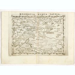
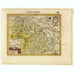
Moschovia nuova tavola.
Scarce FIRST edition of this map centered on Moscow. In the lower left Crimea and the Sea of Azov. The map is filled with small tents to represent Tartar camps.Girolamo R...
- $300 / ≈ €262
Date: Venice, 1561
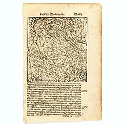
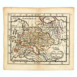
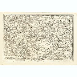
Von dem Moscowycern
Map centered on Moscow, with on verso a wood cut engraving of a Bison. From a German text edition of his Geographia , that great compendium of Renaissance knowledge.
- $125 / ≈ €109
Date: Basle, 1550-1590
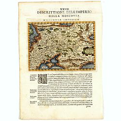
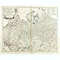
Descrittione Dell'Imperio della MOSCOVIA IMPERIUM.
Uncommon map including Latvia, Livonia, Lithuania, the Ukraine, and northern Part of the Black Sea and the Caspian Sea, Siberia, Georgia, Azerbaijan, Kazakhstan.Giovanni ...
Date: Venice, 1596
![[Nova Zembla]](/uploads/cache/44870-250x250.jpg)
[Nova Zembla]
Charming and decorative miniature map of the Russian island of Nowaya Zemlya. With the depiction of Barentsz.' route. With inset with 2 birds ("Loms Vögel oder Nort...
Date: Frankfurt am Main, 1604
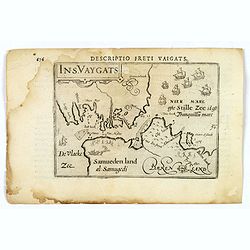
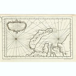
Descriptio Freti Vaigats.
Finely engraved map of the Vaigach Straits, from Bertius's rare miniature atlas. The map focuses on the straits between Novaya Zemlya and the Russian mainland, which had ...
- $150 / ≈ €131
Date: Amsterdam, 1606
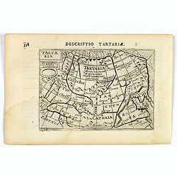
Tartaria.
A fine miniature map showing China, Korea and Russia. Title cartouche on the upper left corner. First published in 1598 in his Caert-Thresoor, the plates were executed by...
- $100 / ≈ €87
Date: Amsterdam, 1606
Moscovia.
Early map of Russia centered on Moscow published in his pocket atlas "Atlas Minor".
- $180 / ≈ €157
Date: Amsterdam, ca. 1625
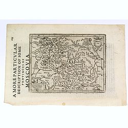
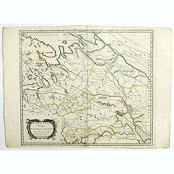
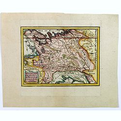
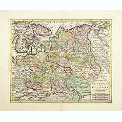
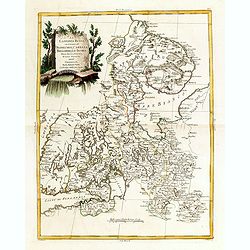
A More Particular Description of some Provinces of Moscovia.
From the English edition of the popular Mercator - Hondius atlas. English text to verso. This map elegantly depicts the Muscovy region of western Russia, with Moscow in t...
- $225 / ≈ €197
Date: Amsterdam, 1630
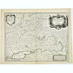
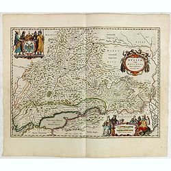
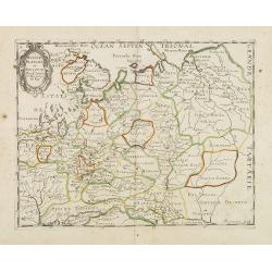
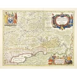
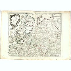
MOSCOVIAE Pars Australis. Auctore Isaaco Massa.
Very decorative map of the region north of the Sea of Azov. The map is based on the travels of Isaac Massa who visited Moscow in 1600 and thus was in the midst of the tur...
- $350 / ≈ €306
Date: Amsterdam, 1650
Russiae vulgo Moscovia pars australis. . .
Shows southern Russia from Crimea to 60 degrees north and from the Volga west to Smolensk. Centered on Moscow. Prepared by Isaac Massa, a Dutch mapmaker who traveled to R...
Date: Amsterdam, 1650
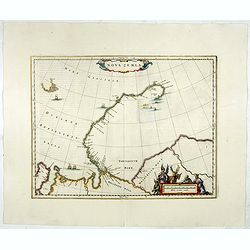
Nova Zemla.
Decorative map decorated with hunters, polar foxes, polar bears and a sea monster.The scalebar in the lower right is in the form of a skewed 'checker-board', to reflect t...
- $900 / ≈ €786
Date: Amsterdam, 1650
Sarmatia utraque europaea et asiatica. . .
Ancient map of the European part of Russia with the Ukraine. Dated 1654.Nicolas Sanson was to bring about the rise of French cartography, although the fierce competition ...
- $200 / ≈ €175
Date: Paris, 1654
Sarmatia utraque europaea et asiatica. . .
Ancient map of the European part of Russia with the Ukraine. Dated 1654.Nicolas Sanson was to bring about the rise of French cartography, although the fierce competition ...
- $300 / ≈ €262
Date: Paris, 1654
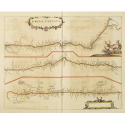
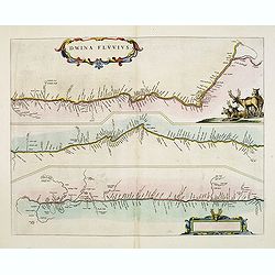
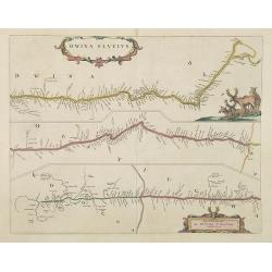
Dwina Fluvius.
An interesting strip-style map showing the course of the Dvina River in three sections from the Black Sea into the White Sea at Archangel. A group of reindeer and two str...
- $750 / ≈ €655
Date: Amsterdam, 1660
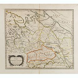
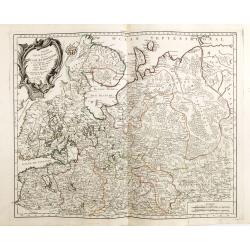
Russiae, vulgo moscoviae dictae, partes septentrionalis et orientalis.
A finely engraved depiction of the area from Estonia to Moscow. The map is based on the travels of Isaac Massa, who visited Moscow in the early 1600s and thus was in the ...
- $550 / ≈ €480
Date: Amsterdam, 1660
Russie blanche ou Moscovie.
Map of the European part of Russia centered on Moscow and prepared by N.Sanson. Published in an early edition of the small Sanson atlas L'Europe Dediée a Monseigneur . ....
- $100 / ≈ €87
Date: Amsterdam, ca. 1660
Fretum Nassovium vulgo de Straet Nassou.
Decorative map of the Nassau Strait, from the Atlas Major. Includes 2 compass roses, sailing ships, rhumb lines and 2 elaborate cartouches. Latin text below and on verso....
Date: Amsterdam, 1662
Dwina Fluvius.
An interesting strip-style map showing the course of the Dvina River in three sections from the Black Sea into the White Sea at Archangel. A group of reindeer and two str...
- $500 / ≈ €437
Date: Amsterdam, 1662
Russie Blanche ou Moscovie.
Map of the European part of Russia prepared by N.Sanson and published by Pierre Mariette.Published in an early edition of the small Sanson atlas L'Europe Dediée a Monsei...
Date: Paris, P. Mariette, 1667
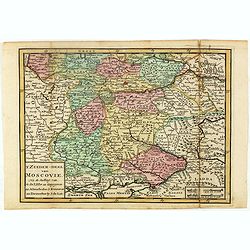
Nouvelle Carte geographique du Grand Royaume de Moscovie. . .
Scarce and detailed map centered on Moscow. Showing to the right the river Wolga and Azof in the south.
- $600 / ≈ €524
Date: Amsterdam, 1680
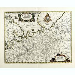
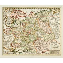
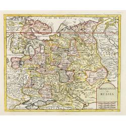
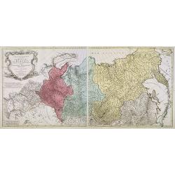
Imperii Russici sive Moscoviae . . .
With the imprints of Pierre Mortier, Amsterdam map seller and Christopher Browne, indicating London publication about 1700. De Wit gives credit to Nicolas Witsen, Amsterd...
- $500 / ≈ €437
Date: Amsterdam, 1680
Moscovia pars Australis.
Prepared by Isaac Massa, a Dutch map-maker who traveled to Russia, returning to Holland in 1609, bringing with him a large amount of original cartographic manuscript mate...
- $1000 / ≈ €874
Date: Oxford, 1682
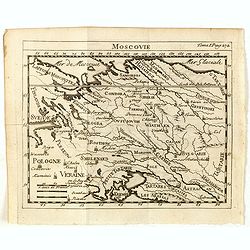
Moscovia or Russia
A rare late seventeenth-century English map of Russia and the Crimea and southern Ukraine, with the northern coast of the Black Sea and its shores. A scarce little map ut...
- $300 / ≈ €262
Date: London, 1685
Dwina Fluvius.
Covens and Mortier's re-print of Joan Blaeu's map of 1662, first issued in the Atlas Maior. The course of the river from its source, a confluence in the Vologod Province ...
Date: Amsterdam, 1700
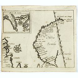
(Map of Nova Zembla with inset of Baye de Loms.)
Map of Nova Zembla with inset of Baye de Loms (5x7mm.). From the French reissue of the account of early Dutch voyages first published in 1608 by Commelin. The French tran...
- $110 / ≈ €96
Date: Amsterdam, E. Roger, 1702
Estats du Grand Duc de Moscovie.
Lovely small map of' Russia in Europe', extending from Poland and the Baltic in the west, Zembla in the frozen north, reaching down south to the Ukraine with Kiev and par...
- $150 / ≈ €131
Date: Paris, 1705
Carte de Moscovie dresseé par G.De L'Isle. . .
Detailed map of Russia centered on Moscow, including Lapland, prepared by de L'Isle and published in Amsterdam. With fine uncolored title cartouche.
- $375 / ≈ €328
Date: Paris, 1706
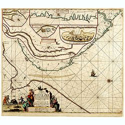
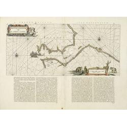
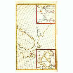
Paskaart van de Mont van de Witte Zee,. Beginnende van Tiepena tot Pelitza, als mede van C. Cindenoes tot Catsnoes.
Fine sea chart of the southern part of the Barents Sea, oriented to the West. With 5 inset maps: - Swetenoes, de Kust van Laplandt, Lombascho, "T Vaste Landt van Lap...
- $1000 / ≈ €874
Date: Amsterdam, c.1710
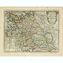
Estats du Grand Duc de Moscovie ou de L'Empereur de la Russie Blanche. . .
The very rare first edition published by Antoine Menard in 1711 in "Le Nouveau et Curieux Atlas géographique et historique.". The map is more commonly found in...
- $500 / ≈ €437
Date: Paris, 1711
Estats du Grand Duc de Moscovie ou de L'Empereur de la Russie Blanche. . .
Lovely small map of central Russia with decorative title cartouche and a panel in the lower left corner listing local rulers.From Le Nouveau et Curieux Atlas Geographique...
- $150 / ≈ €131
Date: Paris, 1719
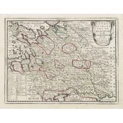
Estats du Grand Duc de Moscovie ou de L'Empereur de la Russie Blanche. . .
Lovely small map of central Russia with decorative title cartouche and a panel in the lower left corner listing local rulers.From Le Nouveau et Curieux Atlas Geographique...
- $150 / ≈ €131
Date: Paris, 1719
La Moscovie septentrionale . . .
Decorative view of area north of Moscow. This well-executed engraving was published in 1729 and 1727 by Pieter van der AA, in Leiden in "Les Voyages tres-curieux et ...
- $250 / ≈ €218
Date: Leiden, 1719
La Moscovie meridionale . . .
Decorative map centred on Moscow. This well executed engraving was published in 1729 and 1727 by Pieter van der AA, in Leiden in "Les Voyages tres-curieux et tres-re...
- $300 / ≈ €262
Date: Leiden, 1719
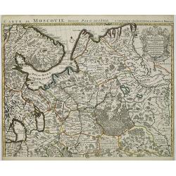
Partie Meridionale de Moscovie..
Centered on Moscow, including Azow in the bottom part of the map.The Amsterdam publishing firm of Covens and Mortier (1721 - c. 1862) was the successor to the extensive p...
- $300 / ≈ €262
Date: Amsterdam 1720
Carte de Moscovie. . .
Centred on Moscow, including Lapland. With fine uncolored title cartouche.
Date: Amsterdam, 1720
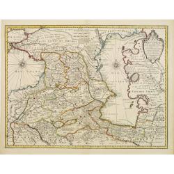
Carte des Pays voisins de la Mer Caspiene. . .
A most attractive and detailed map of the region between the Black and Caspian Seas after De L'Isle. The two Seas are decorated with compass roses. This is one of the few...
Date: Amsterdam, 1720
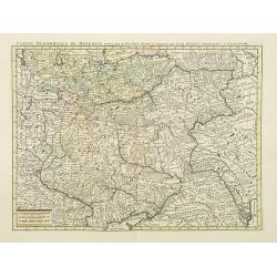
Partie Meridionale de Moscovie. . .
Scarce map centered on Moscow including Azow and part of present-day Ukraine in the bottom part of the map. The map is based on Delisle's important map of the region with...
- $750 / ≈ €655
Date: Amsterdam, 1720
Partie Meridionale de Moscovie. . .
Centered on Moscow including Azow and part of present-day Ukraine in the bottom part of the map. The map is based on Delisle's important map of the region with revisions ...
- $200 / ≈ €175
Date: Amsterdam, 1720
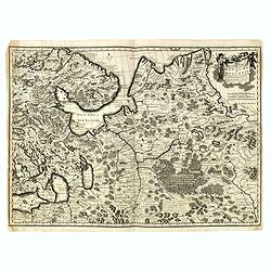
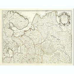
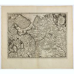
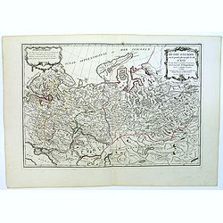
Russiae vulgo Moscovia dictae, Partes Septentrionalis. . .
In the north the Murmansk Sea. Including the western coast of Nova Zembla. Title cartouche and two cartouches, the bottom right one showing two hunters, bears, stags etc....
Date: Amsterdam, 1720
(Map of Nova Zembla with inset of Baye de Loms.)
Map of Nova Zembla with inset of Baye de Loms (5x7mm.).From the French reissue of the account of early Dutch voyages first published in 1608 by Commelin. The French trans...
- $100 / ≈ €87
Date: Amsterdam, F. Bernard, 1725
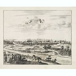
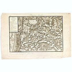
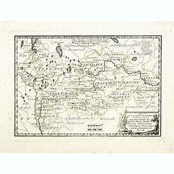
Moruma ville de la Tartarie Moscovite.
Decorative view of the town of Moruma, Russian city near the northern shore of the Caspian sea as seen from across the river Oka. This well executed engraving was publish...
Date: Leiden, 1719-1727
A Chart of the Sound -- A Map of the rivers Elbe and Weser -- The River Dvina and the harbour of Archangel.
Scarce sea chart by John Harris (1667?-1719) and James Knapton (d. 1738). Chart 20 from "Atlas maritimus & commercialis", shows Lapland and part of the Russ...
- $400 / ≈ €349
Date: London, J. Knapton, 1728
Russia or Moscovy with its Acquisitions &c.
Herman Moll's map of western Russia, or Muscovy, published in London during the first half of the eighteenth century. It shows the newly acquires lands taken from Sweden ...
Date: London, 1729
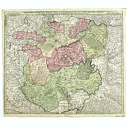
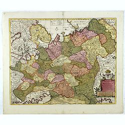
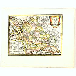
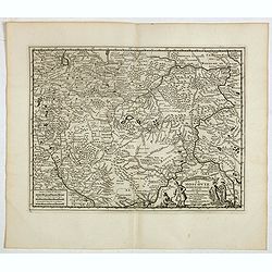
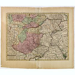
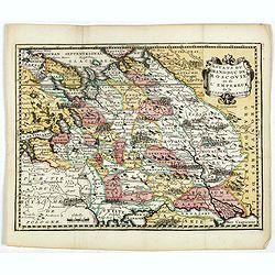
Imperii Moscovitici pars Australis.
A detailed map of the region around Moscow. Including the Ukraine and Cossack regions, to the west is Russian Poland and Lithuania, to the east Russian Tartary and Siberi...
- $500 / ≈ €437
Date: Augsburg, 1730
Nieuwe Kaart van Muskovie of Rusland..
Detailed map of European Russia, far south to the Black Sea and Caspian Sea. Isaac Tirion was born in Utrecht ca. 1705. He came to Amsterdam ca. 1725. Tirion published a ...
Date: Amsterdam, 1734
Nieuwe Kaart van Muskovie of Rusland.
Detailed map of European Russia, far south to the Black Sea and Caspian Sea. Isaac Tirion was born in Utrecht ca. 1705. He came to Amsterdam ca. 1725. Tirion published a ...
- $150 / ≈ €131
Date: Amsterdam, 1734
Nieuwe kaart van Muskovien door M. de l'Isle.
This lovely little map of the area surrounding Moscow is based on Delisle's map of the region. The map is bounded by Lake Ilmen in the north, the Volga River to the east,...
- $100 / ≈ €87
Date: Amsterdam, 1735
Moscovia o Russia.
Map showing European Russia and is centered on Moscow. In the lower right corner, title cartouche with scale and the town of Astrakhan. From "Atlante Novissimo Che C...
Date: Venice, 1740
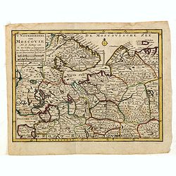
'T Noorderdeel van Moscovie Na de stelling van G. de L'Isle. . .
Attractive and rare map of part of Russia, including St. Persburg, Archangel, Finland, Lapland and Moscow. From Atlas Portatif .
- $100 / ≈ €87
Date: Deventer, 1742
Estats du Grand duc de Moscovie ou de l'Empereur de la Russie Blanche.
Uncommon map of European Russia centered on Muscovy. Charming title cartouche in upper right corner.
- $300 / ≈ €262
Date: Amsterdam, ca 1749
Imperium Moscoviae.
Map of the empire of Moscovia
- $300 / ≈ €262
Date: Nuremberg, 1750
Moscovie.
Scarce small map centered on Muscovy and based on cartography of Guillaume Delisle (. Published in "Nouveau traité de geographie par M**** ", published by La v...
- $50 / ≈ €44
Date: Paris, 1752
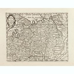
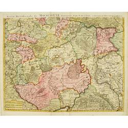
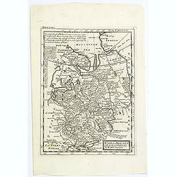
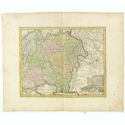
Partie Septentrionale de la Russie Européenne . . .
Detailed map of European part of Russia, including Finland, Lapland.
Date: Paris, 1753
Partie Septentrionale de la Russie Européenne . . .
Detailed map of European part of Russia, including Finland, Lapland.
- $100 / ≈ €87
Date: Paris, 1753
Troisième partie de la carte d'Asie, contenant la Sibérie, et quelques autres parties de la Tartarie. . .
Engraved map of Tartary on two sheets, with country boundaries in outline color. Includes geographic notes and ornamental cartouche by "H. Gravelot, invenit., DeLafo...
Date: Paris, 1753
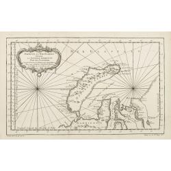
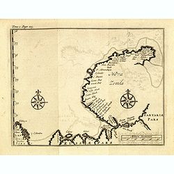
Partie de la Mer Glaciale contenant de la nouvelle Zemble..
A good engraved map of Nova Zembla. The geographical features are typical with somewhat exaggerated bays and inlets. From l'Histoire générale des voyages .
- $80 / ≈ €70
Date: Paris, 1758
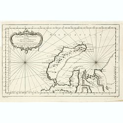
Partie De La Mer Glaciale Contenant La Nouvelle Zemble et Le Pais Des Samoiedes . . . 1758
Detailed map of Nova Zembla and part of the Northeast passage.From Prevost's l'Histoire générale des voyages , the map prepared by J.N. Bellin. Jacques Nicolas Bellin (...
- $60 / ≈ €52
Date: Paris, 1758
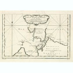
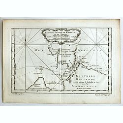
Carte du Detroit de Waigats ou de Nassau. . . 1758. N°.2.
Showing the Dutch voyage of 1594 which proved Nova Zemlya was an island separated from the continent by the "le Waigats Detroit". Several sounding shown.From Pr...
- $40 / ≈ €35
Date: Paris, 1758
Partie De La Mer Glaciale Contenant La Nouvelle Zemble et Le Pais Des Samoiedes . . . 1758
Detailed map of Nova Zembla and part of the Northeast passage.From Prevost's l'Histoire générale des voyages , the map prepared by J.N. Bellin. Jacques Nicolas Bellin (...
- $50 / ≈ €44
Date: Paris, 1758
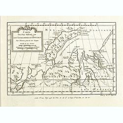
Carte des Païs habités par les Samojedes et Ostiacs, pour l'histoire générale des voyages.
Map shows Nova Zembla and the area of northern Russia that was inhabited by the Samoyeds and Ostiacs.Prepared by Jacques Nicolas Bellin after Dutch sources and included i...
- $75 / ≈ €66
Date: Paris, 1760
Carte du Détroit de Waeigats ou de Nassau.
An interesting map of the Northern Passage in Russia. Prepared by Jacques Nicolas Bellin after Dutch sources and included in Prévost d' Exile's "Histoire des Voyage...
- $50 / ≈ €44
Date: Paris, 1738-1775
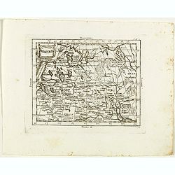
Carte géographique contenant le royaume de Sibérie . . .
Scarce and highly detailed map of Siberia subdivided into three provinces, namely Tobolsk, Jenissejesk, Irkutsk, and outer parts of the Tartary.In upper right corner inse...
Date: Augsburg, c. 1770-1780
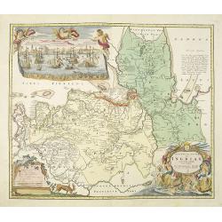
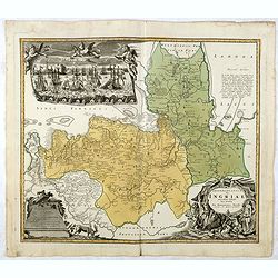
Ingermanlandiae seu Ingriae novissima tabula luci tradita. . .
Detailed map centered on Saint Petersburg. With imposing title cartouche and panoramic view of Saint Petersburg. The map was drawn shortly after the conclusion of the Gre...
Date: Nurenberg, 1780
Partie Septentrionale de la Russie Européenne . . .
Detailed map of European part of Russia, including Finland and Lapland.
Date: Paris, 1780
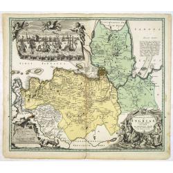
Ingermanlandiae seu Ingriae. . .
Detailed map centered on St.Petersburg. With imposing title cartouche and panoramic town-view of St.Petersburg. The map was drawn shortly after the conclusion of the Grea...
- $750 / ≈ €655
Date: Nurenberg, 1780
Ingermanlandiae seu Ingriae novissima tabula luci tradita. . .
Detailed map centered on St. Petersburg. With imposing title cartouche and panoramic view of St. Petersburg. The map was drawn shortly after the conclusion of the Great N...
Date: Nurenberg, 1780
T Zuider-Deel van Moscovie.
Map details the regions South from Moscow to the Black Sea and the Sea of Azof.
- $150 / ≈ €131
Date: Deventer, ca 1780
Moscovia.
Rare map of western Russia centered on Moscow, from "Atlante Novissimo ad uso Dei Giovani Studiosi Contenuto In Carte XXVII.", published by Giovanni Zempel in R...
- $100 / ≈ €87
Date: Rome, 1780
Governo di Arcangelo, e sue Provincie Nella Russia Europea . . .
Map shows the island Nova Zembla and the government of Archangel, Jarensk and Chlynow. Engraved by G. Zuliani and G. Pitteri.Published in Zatta's "Atlante Novissimo&...
- $375 / ≈ €328
Date: Venice, 1782
La Lapponia Russa con Governi di Olonechoi, Carelia, Bielozero, ed Ingria. . .
An attractive and detailed map of Western Russia with Lapland and Finland, including the towns of St. Petersburg, Kola, and Helsinki. Decorative and large pictorial carto...
- $375 / ≈ €328
Date: Venice, 1782
Plan et coupe horisontale du labyrinte souterrain de Koungour Renvoi.
Engraved map of the Urals with the town Kungur in Russia. With a lettered key A-P in left corner. From the Atlas Volume of "Histoire physique, morale, civile et poli...
Date: Paris, 1783
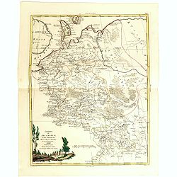
Russie d'Europe avec la partie la plus peuple de celle d'Asie...
A detailed map covering what was 'Russia in Europe', toward the end of the eighteenth century. Decorated with a decorative title cartouche, and an 'Advertisement'.Boundar...
- $150 / ≈ €131
Date: Paris, ca 1783
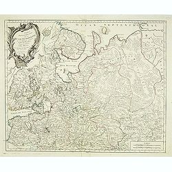
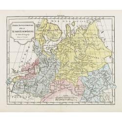
Partie Septentrionale de la Russie Europeenne ou sont distinguees exactement toutes les Provinces, d'apres le detail de l'Atlas Russien, Par le Sr. Robert de Vaugondy fils, Geog. Ordin? Du Roi.
Detailed map of northern European Russia, including Finland. The map was first published by the Venetian cartographer and publisher François (Père) Santini and first pu...
Date: Venice, 1784
Partie Occidentale de l'Empire de Russie en Asie. . .
Finely and crisply engraved map of the north-western part of Russia, with noteworthy topographical detail.Ornamental title cartouche in the upper left corner surrounded w...
- $300 / ≈ €262
Date: Venice, 1776 - 1784
Partie Septentrionale de la Russie Europeenne ou sont distinguees exactement toutes les Provinces, d'apres le detail de l'Atlas Russien, Par le Sr. Robert de Vaugondy fils, Geog. Ordin? Du Roi.
Detailed map of northern European Russia, including Finland. The map was first published by the Venetian cartographer and publisher François (Père) Santini and first pu...
- $250 / ≈ €218
Date: Venice, 1784
Partie Septentrionale de la Russie Europeenne ou sont distinguees exactement toutes les Provinces, d'apres le detail de l'Atlas Russien, Par le Sr. Robert de Vaugondy fils, Geog. Ordin? Du Roi.
Detailed map of northern European Russia, including Finland. The map was first published by the Venetian cartographer and publisher François (Père) Santini and first pu...
Date: Venice, 1784
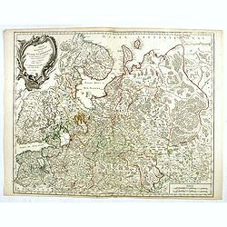
Des Russischen Reiches Statthalterschaften Pleskow, Polozk, Mohilew, Twer, Moskau, Koluga, Wolodimer, Iaroslaw, Tula, Smo, Lensko und Nischgorod. Nro.64
Map of the European part of Russia, centered on Moscow. Published by Franz Johann Joseph von Reilly, 1766-1820, who was a Viennese art dealer who turned to map publishing...
- $150 / ≈ €131
Date: Vienna, 1789
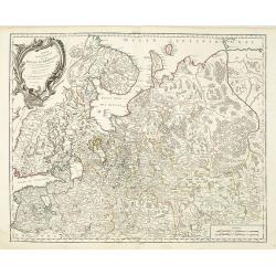
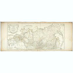
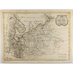
Des Russischen Reiches Statthalterschaft Archangel Nro.66
Map of the North Western part of Russia. Published by Franz Johann Joseph von Reilly, 1766-1820, who was a Viennese art dealer who turned to map publishing in his early t...
- $150 / ≈ €131
Date: Vienna, 1789
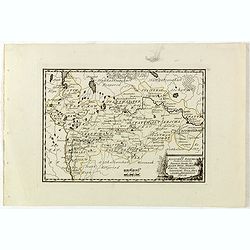
Des Russischen Reiches Statthalterschaften Pleskow, Polozk, Mohilew, Twer, Moskau, Koluga, Wolodimer, Iaroslaw, Tula, Smo, Lensko und Nischgorod. Nro.64
Map of the European part of Russia, centered on Moscow. Published by Franz Johann Joseph von Reilly, 1766-1820, who was a Viennese art dealer who turned to map publishing...
- $150 / ≈ €131
Date: Vienna, 1789
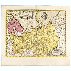
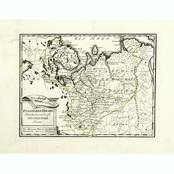
I Governi D'Arcangelo e Bielo-Ozero. . .
An unusual Vincenzo Pazzini Carli's copper engraved map of northern part of Russia in Europe, published in 1789. The map is filled with excellent topographic detail and ...
Date: Rome, 1789
