Browse Listings in Europe > Russia / Baltic / Black Sea region
Carte de L'Asie Mineure ou de la Natolie et du Pont Euxin
Johann Baptist Homann's well-engraved map of Asia Minor, the Black Sea ( Ponti Euxin), Crimea and a part of Greece. Depicts Turkey and the area surrounding the Black Sea ...
Date: Nuremberg, ca. 1748
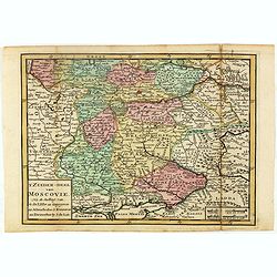
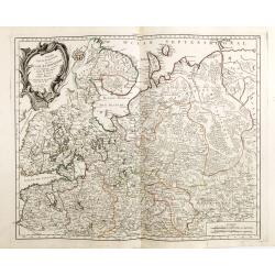
Estats du Grand duc de Moscovie ou de l'Empereur de la Russie Blanche.
Uncommon map of European Russia centered on Muscovy. Charming title cartouche in upper right corner.
- $300 / ≈ €262
Date: Amsterdam, ca 1749
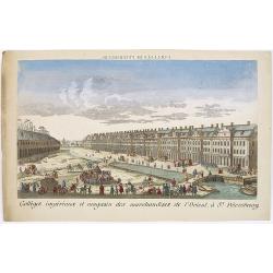
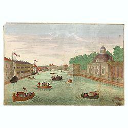
Colléges impériaux et magasin des marchandises de l'Orient, à St. Pétersbourg.
Showing a busy scene at the international trading grounds of 18th century Saint Petersburg, showing the warehouses of the different international trading companies. J. Ch...
- $200 / ≈ €175
Date: Paris, ca. 1750
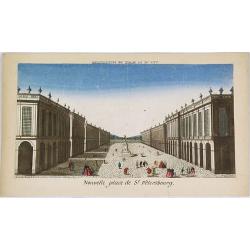
Nouvelle place de St. Pétersbourg.
Showing a square at 18th century Saint Petersburg. J. Chereau was a publisher of optical prints, established in Paris, rue St.Jacques.In the eighteenth and nineteenth ce...
- $200 / ≈ €175
Date: Paris, ca. 1750
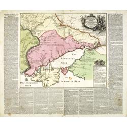
Charte der Kriegs Operationen am Donn u: Dnieper Ihro Russisch Kayserl Majestaet Glorieusen Armeen A: 1736.
Very rare separately published map of the southern part of Ukraine, with an explanatory key A-N in the lower right. The map is surrounded by letterpress German text givin...
Date: Augsburg, 1750
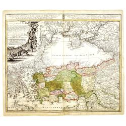
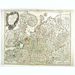
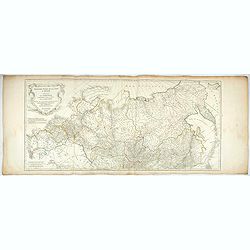
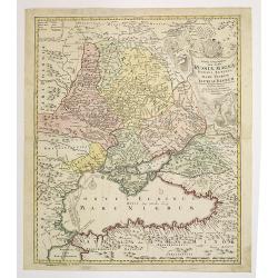
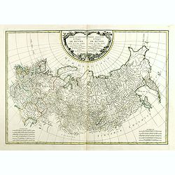
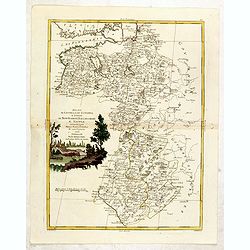
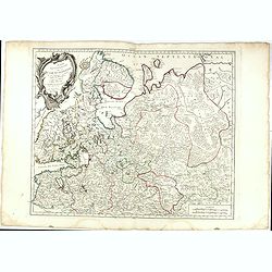
Tabula Geographica qua pars Russiae Magnae. . .
Homann's map is based upon the works of George von Mengden (1628-1702), a Livonian cartographer who worked for Peter the Great and Count Jacob Bruce [Graf Jakov Villimovi...
Date: Nuremburg, after 1750
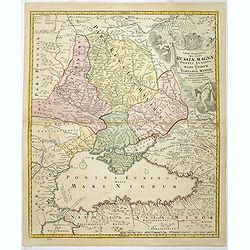
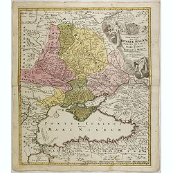
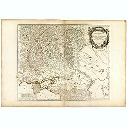
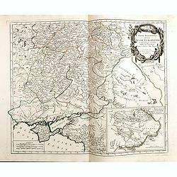
Tabula Geographica qua pars Russiae Magnae Pontus Euxinus seu Mare Nigrum et Tartaria Minor.
Homann's map is based upon the works of George von Mengden (1628-1702) a Livonian cartographer who worked for Peter the Great and Count Jacob Bruce [Graf Jakov Villimovic...
- $750 / ≈ €655
Date: Nuremburg, after 1750
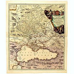
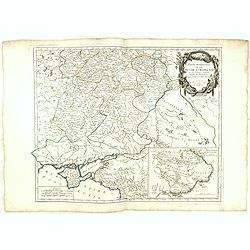
Tabula Geographica qua pars Russiae Magnae Pontus Euxinus seu mare Nigrum et Tartaria Minor cum finitimis Bulgariae, et Romaniae et Natoliae. . .
Homann's map is based upon Beauplan's general map of Ukraine but depicts the political changes of the preceding years. Shows Constantinople. Extends north to Moscow and S...
Date: Nuremburg, 1750
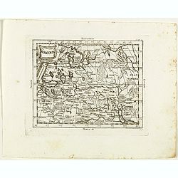
Imperium Moscoviae.
Map of the empire of Moscovia
- $300 / ≈ €262
Date: Nuremberg, 1750
Charte der Kriegs Operationen am Donn u: Dnieper Ihro Russisch Kayserl Majestaet Glorieusen Armeen A: 1736
Scarce separately published map of the southern part of Ukraine, with an explanatory key A-N in the lower right. The map is surrounded by letterpress German text giving a...
Date: Augsburg, 1750
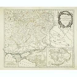
Partie Méridionale de la Russie Européenne. . .
Detailed map of Ukraine, the Crimea and the northern part of the Caspian Sea.
Date: Paris, 1752
Moscovie.
Scarce small map centered on Muscovy and based on cartography of Guillaume Delisle (. Published in "Nouveau traité de geographie par M**** ", published by La v...
- $50 / ≈ €44
Date: Paris, 1752
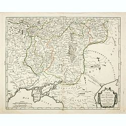
Partie méridionale de la Russie Européenne. . .
Detailed map of Ukraine and the Crimea. In lower right corner inset map of Cosaques. From his "Atlas Universel".Gilles Robert de Vaugondy (1688–1766), also kn...
Date: Paris, 1752
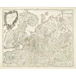
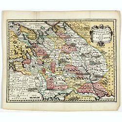
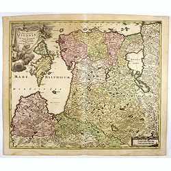
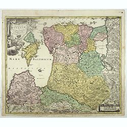
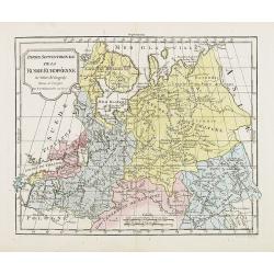
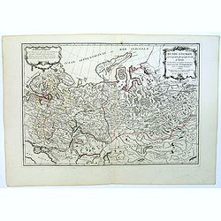
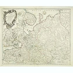
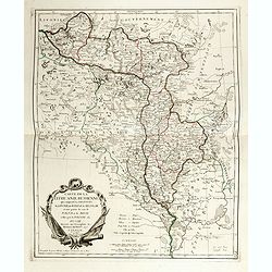
Partie Septentrionale de la Russie Européenne . . .
Detailed map of European part of Russia, including Finland, Lapland.
Date: Paris, 1753
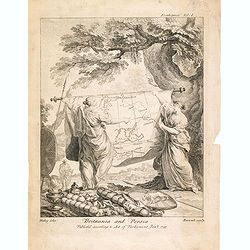
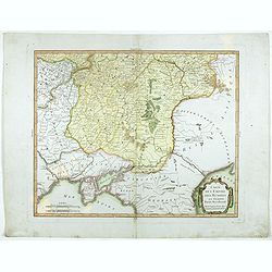
Britannia And Persia.
A finely engraved and unusual depiction of Britannia and Persia, two women with spears and shields holding a map between them. This map depicts a route through the Baltic...
- $800 / ≈ €699
Date: London, 1753
Partie Septentrionale de la Russie Européenne . . .
Detailed map of European part of Russia, including Finland, Lapland.
- $100 / ≈ €87
Date: Paris, 1753
Troisième partie de la carte d'Asie, contenant la Sibérie, et quelques autres parties de la Tartarie. . .
Engraved map of Tartary on two sheets, with country boundaries in outline color. Includes geographic notes and ornamental cartouche by "H. Gravelot, invenit., DeLafo...
Date: Paris, 1753
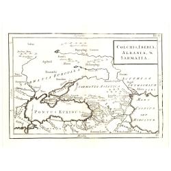
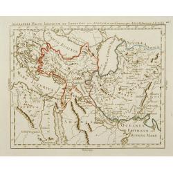
Colchis, Iberia, Albania..
Uncommon map covering the area in-between the Caspian Sea and the Black Sea. With title in upper right corner.
Date: London, 1755
Theatrum belli Russorum Victoriis illustratum sive Nova et accurata Turcicarum et Tartaricum. . .
Uncommon and decorative map of Ukraine, showing the theatre of the Russo-Turkish War in the Ukraine in 1735-1739. The map gives detailed information of the fortifications...
Date: Nuremberg, ca. 1757
Spatiosissimum Imperium Russiae Magnae juxta recentissimas Observationes Mappa Geographica . . .
This is a decorative map of greater Russia, extending from Livonia in the west to Kamchatka, China, Tibet, Taiwan, Korea, and part of Japan in the east. To the south, it ...
- $1300 / ≈ €1136
Date: Augsburg, 1757
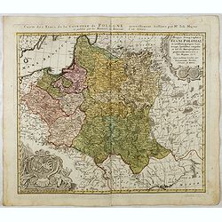
Mappa Geographica Regni Poloniae ex novissimis quotquot sunt mappis specialibus composita et al L.L. Stereographicae projectionis revocata a Tob. Mayero. . . .
Decorative map of Poland after Tobias Mayer who was based on Barnikel's map of Curland (1747) and Jan Nieprzecki's map of Lithuania (1749).Poland extends from Glogau and ...
Date: Nuremberg, 1757
![[Lot of 8 maps of European Russia] Partie Septentrionale de la Russie Europeenne ou sont distinguees exactement toutes les Provinces](/uploads/cache/18563-(3)-250x250.jpg)
[Lot of 8 maps of European Russia] Partie Septentrionale de la Russie Europeenne ou sont distinguees exactement toutes les Provinces
[Lot of 8 maps of European Russia]- Partie Septentrionale de la Russie Européenne òu sont distinguées exactement toutes les Provinces (1753)- Carte des Pais Habites p...
- $600 / ≈ €524
Date: Atlas Universel PARIS 1757
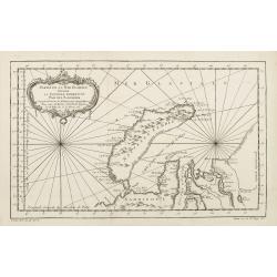
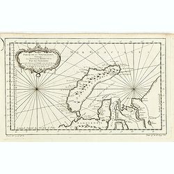
Partie de la Mer Glaciale contenant de la nouvelle Zemble..
A good engraved map of Nova Zembla. The geographical features are typical with somewhat exaggerated bays and inlets. From l'Histoire générale des voyages .
- $80 / ≈ €70
Date: Paris, 1758
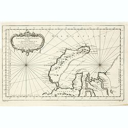
Partie De La Mer Glaciale Contenant La Nouvelle Zemble et Le Pais Des Samoiedes . . . 1758
Detailed map of Nova Zembla and part of the Northeast passage.From Prevost's l'Histoire générale des voyages , the map prepared by J.N. Bellin. Jacques Nicolas Bellin (...
- $60 / ≈ €52
Date: Paris, 1758
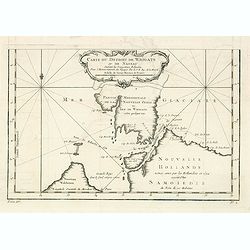
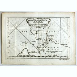
Carte du Detroit de Waigats ou de Nassau. . . 1758. N°.2.
Showing the Dutch voyage of 1594 which proved Nova Zemlya was an island separated from the continent by the "le Waigats Detroit". Several sounding shown.From Pr...
- $40 / ≈ €35
Date: Paris, 1758
Partie De La Mer Glaciale Contenant La Nouvelle Zemble et Le Pais Des Samoiedes . . . 1758
Detailed map of Nova Zembla and part of the Northeast passage.From Prevost's l'Histoire générale des voyages , the map prepared by J.N. Bellin. Jacques Nicolas Bellin (...
- $50 / ≈ €44
Date: Paris, 1758
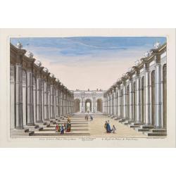
15e. Vüe d'Optique Representant Le Profil du Palais de Petersbourg.
So-called optical print illustrating a perspective view of the portico of a Palace in Saint Petersburg. Published by Daumont, a well-known publisher of optical prints, es...
- $250 / ≈ €218
Date: Paris, 1760

Vue d'un château d'Archangel.
So-called optical print of a street and house in Arkhangelsk, by the well-known publisher of optical prints, Basset, established in rue St.Jacques in Paris. In the eighte...
- $300 / ≈ €262
Date: Paris, 1760
Carte géographique représentant le théâtre de la guerre entre les Russes, les Turcs et les Polonois confédérés. . .
Interesting and rare map showing the area of the Russo-Turkish Wars. To the right a large title cartouche and extensive text describing the different stages and the Wars ...
- $1500 / ≈ €1310
Date: Augsburg, 1760
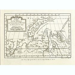
Carte des Païs habités par les Samojedes et Ostiacs, pour l'histoire générale des voyages.
Map shows Nova Zembla and the area of northern Russia that was inhabited by the Samoyeds and Ostiacs.Prepared by Jacques Nicolas Bellin after Dutch sources and included i...
- $75 / ≈ €66
Date: Paris, 1760
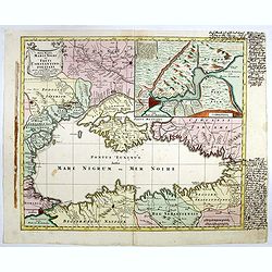
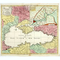
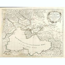
Nova Mappa Maris Nigris et Freti Constantinopolitani...
Map of the Black Sea with the Crimea and adjacent countries, inset map of the Bosporus with Constantinople at upper right.T.C. Lotter married M. Seutter's daughter in 174...
- $600 / ≈ €524
Date: Augsburg, ca. 1760
Dvcatvvm Livoniae et Cvrlandiae cum vicinis insulis nova exhibitio geographica.
A very attractive of Livonia, Estonia, Curlandia and the Baltic coast, which also includes the Gulf of Livonia or Riga.
- $500 / ≈ €437
Date: Nuremberg, 1760
Dvcatvvm Livoniae et Cvrlandiae cum vicinis insulis nova exhibitio geographica.
A very attractive of Livonia, Estonia, Curlandia and the Baltic coast, which also includes the Gulf of Livonia or Riga.
- $450 / ≈ €393
Date: Nuremberg, 1760
Nova Mappa Maris Nigri et Freti Constantino Politani. . .
Decorative and uncommon map the Black Sea region. In upper left hand corner an inset map (200 x 280mm) of the Bosporus including Istanbul. Title engraved onto a drape-sty...
- $450 / ≈ €393
Date: Augsburg, ca. 1760

Vue de la superbe Gallerie de Petersbourg en Russie.
So-called optical print illustrates a perspective view of the interior of a palace in Saint Petersburg.Mondhare was a well-known publisher of optical prints, established ...
- $200 / ≈ €175
Date: Paris, 1761
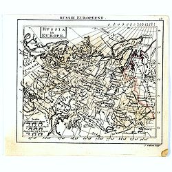
Russia in Europe.
Uncommon miniature map of Russia, engraved by Thomas Kitching for "A New General and Universal Atlas Containing Forty five Maps by Andrew Dury".This miniature a...
- $75 / ≈ €66
Date: London, 1761-1763

Ajustement des Femmes de Valday Situé entre Petersbourg et Moscou.
Etching by Jean-Baptiste Le Prince (1734-1781), from "2me Suite de divers cris de marchands de Russie", showing typical russian customs. The sketches Le Prince ...
- $110 / ≈ €96
Date: Paris, 1764
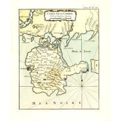
Carte de la Crimée.
Fine map of Crimea (Ukraine) here in the only issue of this version of Bellin's map, slightly larger than the common version. From Bellin's Le Petit Atlas Maritime Recuei...
Date: Paris, 1764
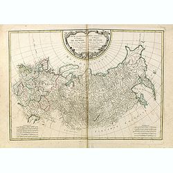
Tabula Geographica qua pars Russiae Magnae. . .
An unrecorded state Homann's map is based upon the works of George von Mengden (1628-1702), a Livonian cartographer who worked for Peter the Great and Count Jacob Bruce [...
Date: Nuremberg, c. 1770
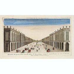
Elevation perspective de la nouvelle place de Petersbourg suivant le projet . . .
Showing a perspective view of the new Palace Square in St. Petersburg. In the 1760s, the Baroque architecture was succeeded by neoclassical architecture.This so-called op...
- $200 / ≈ €175
Date: Paris, ca. 1770
(Hof, Voraths-Magazin, am Fontanka Flus, Zu Petersburg.)
So-called optical print illustrating a perspective view of the river Fontanka in Saint Petersburg. The Fontanka is a branch of the Neva river. At the right of the print w...
- $225 / ≈ €197
Date: Augsburg, c.1770
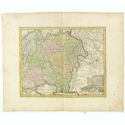
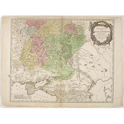
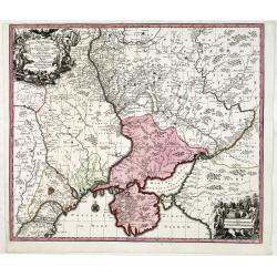
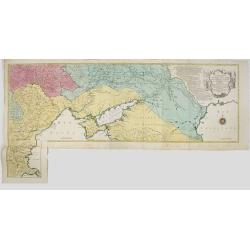
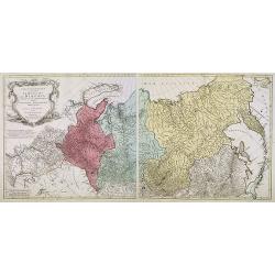
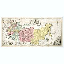
Partie Occidentale de l'Empire de Russie. . . / Partie Orientale de l'Empire de Russie. .
Attractive map of Russia, ornated with a rococo title cartouche. Boundaries outlined in hand color.The detailed map covers from the Baltic Sea to Siberia and the Bering S...
- $400 / ≈ €349
Date: Paris, ca 1771
Partie Occidentale de l'Empire de Russie. . . / Partie Orientale de l'Empire de Russie. .
Attractive map of Russia, ornated with a rococo title cartouche. Boundaries outlined in hand color.The detailed map covers from the Baltic Sea to Siberia and the Bering S...
- $200 / ≈ €175
Date: Paris, ca 1771
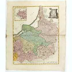
Tabula Regni Borussiae, Borussiam Orientalem exhibens . . .
Kingdom of Prussia, today part of the territory of the Polish, Lithuanian and Russian.
- $750 / ≈ €655
Date: Augsburg, 1775
Carte du Détroit de Waeigats ou de Nassau.
An interesting map of the Northern Passage in Russia. Prepared by Jacques Nicolas Bellin after Dutch sources and included in Prévost d' Exile's "Histoire des Voyage...
- $50 / ≈ €44
Date: Paris, 1738-1775
Charte von Russisch Litauen, welche die von Polen an Russland Abgetretene Woiewodschaften, Liefland, Witepsk, Mscislaw, und einem Theil der Woiewodschaften Polock und Minsk Enthalt.
An uncommon map of Belarus, together with parts of the Ukraine and Lithuania. Shows the rivers Dnieper and Dwiner from Liefland to Mscislaw and Woiwodschaft.. With the to...
- $500 / ≈ €437
Date: Nuremberg, 1775
Carte de la Lithuanie Prussienne qui comprend les Palatinats de Livonie, de Witepsk, de Liscislaw, et une partie de ceux de Polock et de Minsk cédés par la Pologne à la Russie. Dressée sur l'Exemplaire des Héritiers Homann 1775.
Detailed map of the areas along the river Dnieper and Duna. Santini gives credit to Homann Heirs in the cartouche.The map was prepared by the Venetian cartographer and pu...
Date: Venice, 1776
Carte géographique contenant le royaume de Sibérie . . .
Scarce and highly detailed map of Siberia subdivided into three provinces, namely Tobolsk, Jenissejesk, Irkutsk, and outer parts of the Tartary.In upper right corner inse...
Date: Augsburg, c. 1770-1780
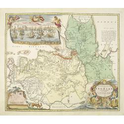
Ingermanlandiae seu Ingriae novissima tabula luci tradita. . .
Detailed map centered on Saint Petersburg. With imposing title cartouche and panoramic view of Saint Petersburg. The map was drawn shortly after the conclusion of the Gre...
Date: Nurenberg, 1780
Partie Septentrionale de la Russie Européenne . . .
Detailed map of European part of Russia, including Finland and Lapland.
Date: Paris, 1780
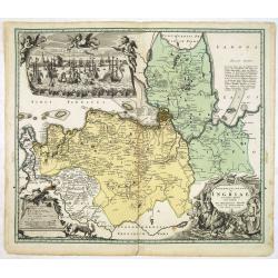
Ingermanlandiae seu Ingriae. . .
Detailed map centered on St.Petersburg. With imposing title cartouche and panoramic town-view of St.Petersburg. The map was drawn shortly after the conclusion of the Grea...
- $750 / ≈ €655
Date: Nurenberg, 1780
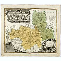
Ingermanlandiae seu Ingriae novissima tabula luci tradita. . .
Detailed map centered on St. Petersburg. With imposing title cartouche and panoramic view of St. Petersburg. The map was drawn shortly after the conclusion of the Great N...
Date: Nurenberg, 1780
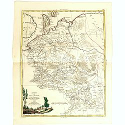
T Zuider-Deel van Moscovie.
Map details the regions South from Moscow to the Black Sea and the Sea of Azof.
- $150 / ≈ €131
Date: Deventer, ca 1780
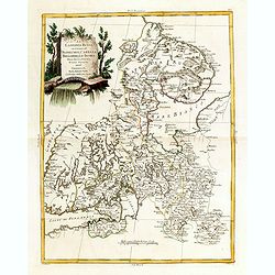
Moscovia.
Rare map of western Russia centered on Moscow, from "Atlante Novissimo ad uso Dei Giovani Studiosi Contenuto In Carte XXVII.", published by Giovanni Zempel in R...
- $100 / ≈ €87
Date: Rome, 1780
Governo di Arcangelo, e sue Provincie Nella Russia Europea . . .
Map shows the island Nova Zembla and the government of Archangel, Jarensk and Chlynow. Engraved by G. Zuliani and G. Pitteri.Published in Zatta's "Atlante Novissimo&...
- $375 / ≈ €328
Date: Venice, 1782
La Lapponia Russa con Governi di Olonechoi, Carelia, Bielozero, ed Ingria. . .
An attractive and detailed map of Western Russia with Lapland and Finland, including the towns of St. Petersburg, Kola, and Helsinki. Decorative and large pictorial carto...
- $375 / ≈ €328
Date: Venice, 1782
Ducati di Livonia e di Estonia, e Governi di Nowogorod...
Shows today's Estonia, and the governorates Nowgorod, Bialgorod and Kiew in today's Russia, Belarus and Ukraine.
- $175 / ≈ €153
Date: Venise, 1782
Alexandri Magni Imperium et Expeditio per Africam et potissimum per Aslam.
Rare map of the Empire of Alexander the Great, prepared by J.B.Nolin and published by Monhare for his Atlas Général a l'usage des colleges et maisons d'education.. Cent...
Date: Paris, 1783
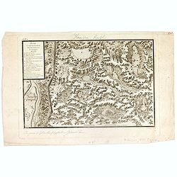
Plan et coupe horisontale du labyrinte souterrain de Koungour Renvoi.
Engraved map of the Urals with the town Kungur in Russia. With a lettered key A-P in left corner. From the Atlas Volume of "Histoire physique, morale, civile et poli...
Date: Paris, 1783
Russie d'Europe avec la partie la plus peuple de celle d'Asie...
A detailed map covering what was 'Russia in Europe', toward the end of the eighteenth century. Decorated with a decorative title cartouche, and an 'Advertisement'.Boundar...
- $150 / ≈ €131
Date: Paris, ca 1783
Partie Méridionale de la Russie Europeenne ou sont distinguees exactement toutes les Provinces, d'après le detail de l'Atlas Russien.
Detailed map of southern European Russia, including Yugoslavia. The map was first published by the Venetian cartographer and publisher François (Père) Santini and first...
Date: Venice, 1784
Partie Septentrionale de la Russie Europeenne ou sont distinguees exactement toutes les Provinces, d'apres le detail de l'Atlas Russien, Par le Sr. Robert de Vaugondy fils, Geog. Ordin? Du Roi.
Detailed map of northern European Russia, including Finland. The map was first published by the Venetian cartographer and publisher François (Père) Santini and first pu...
Date: Venice, 1784
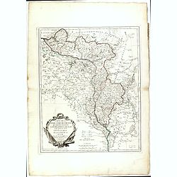
Carte de l'empire des Russies en Europe partie meridionale
Uncommon and detailed map of Ukraine.Published by Pierre Bourgoin in 1784 in his uncommon "Atlas Élémentaire de la Géographie", published at rue de la Harpe ...
- $300 / ≈ €262
Date: Paris, 1784
Partie Occidentale de l'Empire de Russie en Asie. . .
Finely and crisply engraved map of the north-western part of Russia, with noteworthy topographical detail.Ornamental title cartouche in the upper left corner surrounded w...
- $300 / ≈ €262
Date: Venice, 1776 - 1784
Partie Méridionale de la Russie Europeenne ou sont distinguees exactement toutes les Provinces, d'après le detail de l'Atlas Russien.
Detailed map of southern European Russia, including Yugoslavia. The map was first published by the Venetian cartographer and publisher François (Père) Santini and first...
- $600 / ≈ €524
Date: Venice, 1784
Carte de la Lithuanie Russienne qui comprend les Palatinats de Livonie, de Witepsk, de Miscislaw, et une partie de ceux de Polock et de Minsk cédés par la Pologne à la Russie.
Detailed map of the areas along the river Dnieper and Duna. Santini gives credit to Homann Heirs in the cartouche. The map was prepared by the Venetian cartographer and p...
- $500 / ≈ €437
Date: Venice, 1776 - 1784
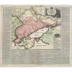
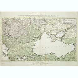
Carte des environs de la Mer Noire. . .
Finely and crisply engraved map centered on Crimea, showing the Black Sea and its hinterland.Noteworthy topographical detail is shown. Decorative title cartouche in the u...
- $500 / ≈ €437
Date: Venice, 1776 - 1784
Partie Méridionale de la Russie Europeenne ou sont distinguees exactement toutes les Provinces, d'après le detail de l'Atlas Russien.
Detailed map of southern European Russia, including Yugoslavia. The map was first published by the Venetian cartographer and publisher François (Père) Santini and first...
- $400 / ≈ €349
Date: Venice, 1784
Partie Septentrionale de la Russie Europeenne ou sont distinguees exactement toutes les Provinces, d'apres le detail de l'Atlas Russien, Par le Sr. Robert de Vaugondy fils, Geog. Ordin? Du Roi.
Detailed map of northern European Russia, including Finland. The map was first published by the Venetian cartographer and publisher François (Père) Santini and first pu...
- $250 / ≈ €218
Date: Venice, 1784
Carte de l'empire des Russies en Europe partie meridionale
Uncommon and detailed map of Ukraine.Published by Pierre Bourgoin in 1784 in his uncommon "Atlas Élémentaire de la Géographie", published at rue de la Harpe ...
- $350 / ≈ €306
Date: Paris, 1784
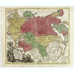
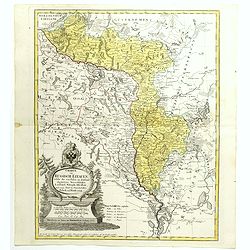
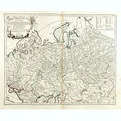
Tabula geographica generalis Imperii Russici ad normam novissimarum observationum astronomicarum concinnata. . .
Important three-sheet map of the Russian Empire under Catherine the Great. This map was first published in St Petersburg in 1775.Scale cartouche is decorated with a rocky...
- $2200 / ≈ €1922
Date: Augsburg, C.Lotter, c.1784
Partie Septentrionale de la Russie Europeenne ou sont distinguees exactement toutes les Provinces, d'apres le detail de l'Atlas Russien, Par le Sr. Robert de Vaugondy fils, Geog. Ordin? Du Roi.
Detailed map of northern European Russia, including Finland. The map was first published by the Venetian cartographer and publisher François (Père) Santini and first pu...
Date: Venice, 1784

Carte de la Petite Tartarie Dresee par ordre de l'Imperatries de toutes las Russies.
The very rare first edition of De Leth's map of the southern part of Ukraine, with detailed annotations regarding the Cossacks and an explanatory key. Based on a Russian ...
- $1750 / ≈ €1529
Date: Amsterdam, ca. 1785
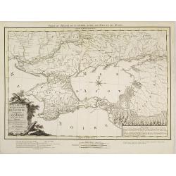
Carte du Gouvernement de Tauride, comprenant la Krimée et les pays voisins: dressée principalement d'après la carte faite sur les lieux pour le voyage de S.M. l'impératrice de Russie. . .
Very rare map of the Crimea area published Jean-Claude Dezauche, who was active in Paris 1770-1824. The map includes borders and a road system.Dezauche is giving credit t...
- $850 / ≈ €743
Date: Paris, 1788
Kriegstheater oder Graenzkarte Oesterreichs, Russlands, und der Türkey. . .
Map of the theatre of war in the Balkans, Ukraine and around the Black Sea, indicating the Austrian, Russian and Turkish spheres of influence. Printed on two sheets and j...
Date: Artaria und Compagnie, Vienna, 1788
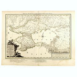
Carte du Gouvernement de Tauride, comprenant la Krimée et les pays voisins: dressée principalement d'après la carte faite sur les lieux pour le voyage de S.M. l'impératrice de Russie. . .
Rare map of southern Ukraine and the Crimea during the Second Russo-Turkish War (1787-92). Antique map of the Crimea during the Second Russo-Turkish War (1787-92), fought...
- $2500 / ≈ €2184
Date: Paris, 1788
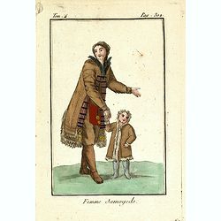
Femme Samoyeds.
Originally hand-colored mezzotint from 'Costumes civils actuels de tous les peuples connus', showing a woman and child from Samojedin, Siberia in Russia. Engraved after J...
- $30 / ≈ €26
Date: M. Sylvain Maréchal. Paris, 1788
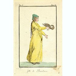
Fille de Barabinze.
Originally hand-colored mezzotint from 'Costumes civils actuels de tous les peuples connus', showing a girl from Barabinze in Siberia, Russia engraved by Félix Mixelle a...
- $30 / ≈ €26
Date: M. Sylvain Maréchal. Paris, 1788
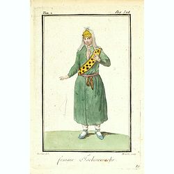
Femme Tschouwache.
Originally hand-colored mezzotint from 'Costumes civils actuels de tous les peuples connus' engraved by Félix Mixelle and Lachaussée Jeune after Jacques Grasset de Sain...
- $30 / ≈ €26
Date: M. Sylvain Maréchal. Paris, 1788
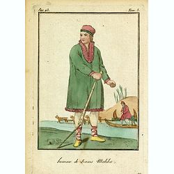
Homme de Kams Malika.
Originally hand-colored mezzotint from 'Costumes civils actuels de tous les peuples connus'. Showing a man from Russia, by M. Sylvain Maréchal. Paris, 1788.As an etcher,...
- $25 / ≈ €22
Date: M. Sylvain Maréchal. Paris, 1788
