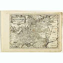
Browse Listings in Europe > Russia / Baltic / Black Sea region > Russia general
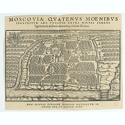
Moscovia Sigismundi Liberi Baronis In Herberstein, Neiperg et Gutehnag Anno M.D XLIX
The forst modern plan of Moscow. A rare and important cornerstone map for Russia collections.Sigismund von Herberstein made two visits to Russia. In 1517-18 he travelled ...
Date: Vienna, 1549
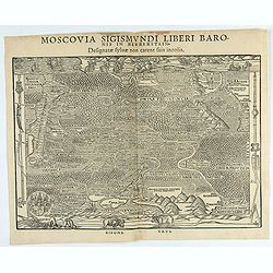
Moscovia Sigismundi Liberi Baronis In Herberstein, Neiperg et Gutehnag Anno M.D XLIX
First Modern Map of Russia. A rare and important cornerstone map for Russia collections.Sigismund von Herberstein made two visits to Russia. In 1517-18 he travelled as a ...
Date: Vienna, 1549
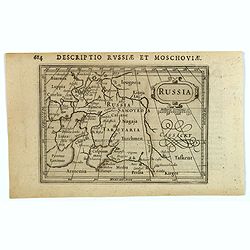
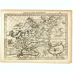
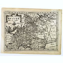
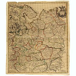
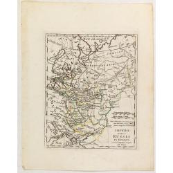
Russia.
Centered on Moscow, with the southern reaches of the map showing Persia, Armenia and Tashkent, the Black and Caspian Seas, and northward to Lapland and the frozen arctic ...
- $200 / ≈ €175
Date: Amsterdam, 1616
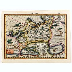
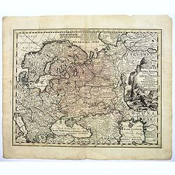
Russia.
Russia map from the rare Cloppenburg edition slightly larger format and more scarce edition of the Mercator/Hondius "Atlas Minor". Engraved by Pieter Van Den Ke...
Date: Amsterdam, 1630
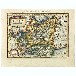
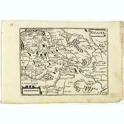
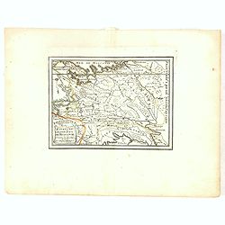
Russia cum Confinijs.
Charming small map of European Russia. Nicely detailed including engraved forests and mountains and embellished with two strapwork cartouches. Latin text on verso.
- $220 / ≈ €192
Date: Amsterdam, 1634
Russia cum confinijs.
A rare map of Russia in a first edition. In the second state the coastline of Scandinavia is completed, the title changed and the name of the engraver Dirck Cornelissen S...
- $250 / ≈ €218
Date: Amsterdam, Cloppenburgh, 1630-1636
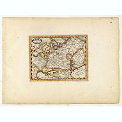
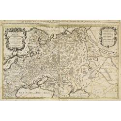
Tabula Russiae.
A re-issue, by Willem Blaeu, of Hessel Gerritsz' rare and influential map of Russia.This fine map was compiled from manuscripts brought back from Russia, by Isaac Massa, ...
Date: Amsterdam, 1644
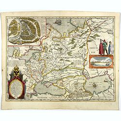
Novissima Russiae Tabula.
Detailed map of Russia including Scandinavia. Bottom left title cartouche and dedication. Prepared by Isaac Masso. Latin text on the verso.
Date: Amsterdam, 1645
Russie avec ses confins...
A rare map published by Jean Boisseau (fl.1637-1658) French geographer, topographer, and genealogist in his Trésor des cartes géographiques. (The first true world atlas...
- $300 / ≈ €262
Date: Paris, 1653
La Russie ou Moscovie.
Scarce map of Russia, centered on Moscow, the map covers much of central Europe, from the Baltic Sea east to the Caspian Sea and from the Arctic Ocean to the Black Sea.Fr...
- $300 / ≈ €262
Date: Paris, 1653
Russie.
Rare map of Russia, published by Jollain in 1667. Published in "Trésor Des Cartes Geographiques Des Principaux Estats de Lunivers".This atlas is based upon Boi...
- $250 / ≈ €218
Date: Paris, 1667
Moscovie avec ses confins.
Rare map of Russia, published by Jollain in 1667. Published in "Trésor Des Cartes Geographiques Des Principaux Estats de Lunivers".This atlas is based upon Boi...
- $450 / ≈ €393
Date: Paris, 1667
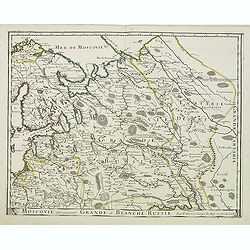
Moscovie dite autrement Grande et Blanche Russie.
Somewhat scarce map of the Russia centered on Moscow, including Finland.
- $450 / ≈ €393
Date: Paris, 1679
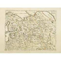
Moscovie dite autrement Grande et Blanche Russie.
Uncommon map of the Russia, including Finland, here with the date 1686.
Date: Paris, 1686
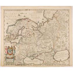
La Russie blanche ou moscovie. . .
Fine map of the European part of Russia with a decorative title and scale cartouche.Alexis-Hubert Jaillot (1632-1712), was a French cartographer. He joined the Sanson hei...
Date: Amsterdam, 1692
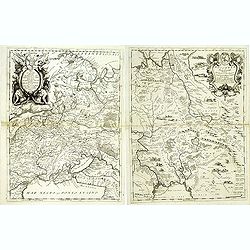
Moscovia Parte Occidentale. . . (with) ... parte orientale Delicata All Illustrissimo Signore Bartolomeo Sardi. . .
Uncommon two-sheet map of Russia extending north from the Caspian Sea to the east of the Gulf of Nova Zembla and the Cosack warriors in the southeast part of the map, all...
Date: Venice, 1695
Estats du Grand Duc de Moscovie . . .
An interesting small map of Moscovie by Nicolas de Fer. From his rare "Petit et Nouveau Atlas". The first edition was published in 1697 and was republished in 1...
Date: Paris, 1697
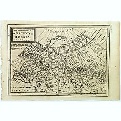
The Dominions of Moscovy or Russia.
A far reaching copperplate map of Russia by the Dutch emigrant Herman Moll. The map extends from Sweden in the west to Tartary and China in the east, to the south both th...
- $110 / ≈ €96
Date: London, 1711
To His Most Serene and August Majesty Peter Alexovitz Absolute Lord of Russia &c. This map of Moscovy, Poland, Little Tartary, and ye Black Sea &c. is most Humbly Dedicated by H. Moll Geographer
Magnificent large-scale, English map of Russia, Ukraine, Poland, Finland and the Baltic Countries and extending south to the Black Sea and the Balkans, with an ornate ded...
Date: London, 1716
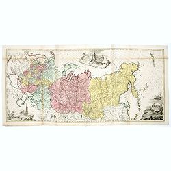
Carte generale des Etats du Czar. Empereur de Moscovie, ou L'on voit ce que ce prince possede en Europe ..
Impressive map of Russia Tartary and part of China with key tables to the towns. Depicting the different states belonging to the Czar in Asia and Europe, showing the path...
- $900 / ≈ €786
Date: Amsterdam, ca. 1720
Moscovey in Europe from the latest Observations . . .
Fine, highly detailed map of the regions of European Russia by John Senex. Each region is depicted in original outline color, and a small decorative cartouche is in the t...
- $450 / ≈ €393
Date: London, 1721
![[Set of 2 maps of Caspian Sea.] Carte marine de la Mer Caspiene. Levee suivant les ordres de S.M. Czariene, P](/uploads/cache/20009-250x250.jpg)
[Set of 2 maps of Caspian Sea.] Carte marine de la Mer Caspiene. Levee suivant les ordres de S.M. Czariene, P
Guillaume de l' Isle (1675-1724), Royal Geographer, was the most influential cartographer of the first quarter of the 18th century. ' Atlas de Géographie' (1700-12), pos...
- $350 / ≈ €306
Date: 1721
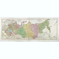
Moscoviae seu Russiae Magnae Generalis Tabula. . .
A scarce and attractive, wide-ranging map of incorporating Scandinavia, the Baltic countries, parts of Germany and Czechoslovakia, Poland, Hungary, Ukraine, Bulgaria, Nor...
- $1500 / ≈ €1310
Date: Augsburg, 1740
![[Lot of 8 maps of European Russia] Partie Septentrionale de la Russie Europeenne ou sont distinguees exactement toutes les Provinces](/uploads/cache/18563-(3)-250x250.jpg)
[Lot of 8 maps of European Russia] Partie Septentrionale de la Russie Europeenne ou sont distinguees exactement toutes les Provinces
[Lot of 8 maps of European Russia]- Partie Septentrionale de la Russie Européenne òu sont distinguées exactement toutes les Provinces (1753)- Carte des Pais Habites p...
- $600 / ≈ €524
Date: Atlas Universel PARIS 1757
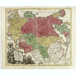
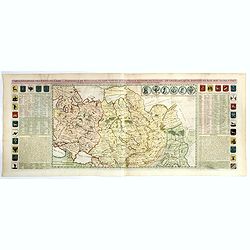
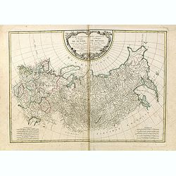
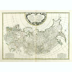
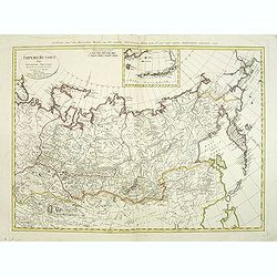
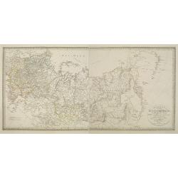
Spatiosissimum Imperium Russiae Magnae juxta recentissimas Observationes Mappa Geographica . . .
This is a decorative map of greater Russia, extending from Livonia in the west to Kamchatka, China, Tibet, Taiwan, Korea, and part of Japan in the east. To the south, it ...
- $1300 / ≈ €1136
Date: Augsburg, 1757
Russia in Europe.
Uncommon miniature map of Russia, engraved by Thomas Kitching for "A New General and Universal Atlas Containing Forty five Maps by Andrew Dury".This miniature a...
- $75 / ≈ €66
Date: London, 1761-1763
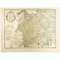
Partie Occidentale de l'Empire de Russie. . . / Partie Orientale de l'Empire de Russie. .
Attractive map of Russia, ornated with a rococo title cartouche. Boundaries outlined in hand color.The detailed map covers from the Baltic Sea to Siberia and the Bering S...
- $200 / ≈ €175
Date: Paris, ca 1771
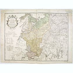
Partie Occidentale de l'Empire de Russie. . . / Partie Orientale de l'Empire de Russie. .
Attractive map of Russia, ornated with a rococo title cartouche. Boundaries outlined in hand color.The detailed map covers from the Baltic Sea to Siberia and the Bering S...
- $400 / ≈ €349
Date: Paris, ca 1771
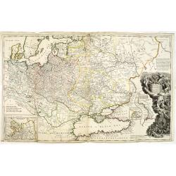
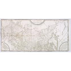
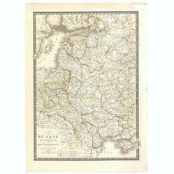
Tabula geographica generalis Imperii Russici ad normam novissimarum observationum astronomicarum concinnata. . .
Important three-sheet map of the Russian Empire under Catherine the Great. This map was first published in St Petersburg in 1775.Scale cartouche is decorated with a rocky...
- $2200 / ≈ €1922
Date: Augsburg, C.Lotter, c.1784
Carte générale de l'empire de Russie.
Map of Russia. Map from a second French edition of Peter Simon Pallas' Voyages du Professeur Pallas, dans Plusieurs Provinces de l’Empire de Russie et dans l’Asie Sep...
Date: Paris, Maradan, 1794
The European Part of the Russian Empire . . .
Highly detailed map of the Russian Empire at the end of the 18th Century, by William Faden.The map is a significant advance from the earlier maps by Kitchin, Sayer and Je...
- $800 / ≈ €699
Date: London, 1794
Imperii Russici Pars Orientem Spectans Tab. II da. ex optimis subsidiis delineata a. C. Mannert Norimberge Prostat in Officina A. G. Schneideriana. . .
The Russian empire eastward from the Dvina River, indicating some unexplored coastlines in Nova Zemlya and northeastern Siberia. Includes an inset with a portion of Alask...
Date: Nurernberg, 1794
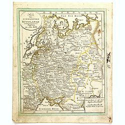
Karte von dem Russischen Reiche in Europa . . .
An attractive large map of European Russia, including Finland. Very detailed with rivers lakes mountains etc. Russia with a decorative title cartouche in the upper left-h...
- $650 / ≈ €568
Date: Vienna, 1796
Karte von dem Russischen Reiche in Europa . . .
An attractive map of European Russia. Very detailed with rivers lakes mountains etc. Russia with a decorative title cartouche in the upper left-hand corner. Engraved by F...
- $650 / ≈ €568
Date: Vienna, 1796
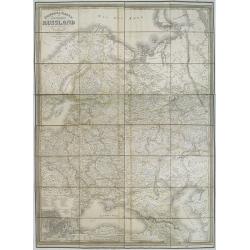
![[2 maps] Des europäischen Russlands nördlicher Theil. / Des europäischen Russlands sûdlicher Theil.](/uploads/cache/34707-250x250.jpg)
[2 maps] Des europäischen Russlands nördlicher Theil. / Des europäischen Russlands sûdlicher Theil.
Detailed map of Russia in two sheets, published by Johannes Wach of Augsburg.
- $250 / ≈ €218
Date: Augsburg, 1803

Carte des routes de poste de la Russie européenne, exécutée par ordre de S.E.M. le duc de Feltre ministre de la Guerre, ...
Post-route map on a scale of 1:2 500 000 made during the French campaign in Russia, which began June 24, 1812. With a table of the conventional signs and a table of conve...
Date: Paris, Dépôt Général de la Guerre 1812
Charte des ganzen Russischen Reichs in Europa und Asien : Nach den neuesten und sichersten astronomischen Ortsbestimmungen entworfen und berichtiget auf der Sternwarte Seeberg bey Gotha gezeichnet von I. C. M. Reinecke. . .
Uncommon two-sheet map of Russia, prepared by Johann Matthias Christoph Reinecke (1770-1818). The map's information is off by 20 degrees longitude as the prime meridian ...
Date: Weimar, 1817
Karte des Europaeischen Russland. . ..
Nice small map of Russia.
- $100 / ≈ €87
Date: Augsburg, 1820
Impero della Russia in Europa a riserva delle ultime Conquiste sulla Polonia.
Charming map of the European part of Russia, including Finland, from the rare atlas Atlante Tascabile o sia Serie di Num. XXI Cartine Geografiche nelle quali si In Roma...
- $200 / ≈ €175
Date: Rome, 1823
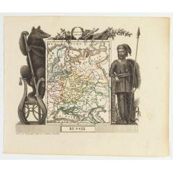
Russie
Attractive map of Russia with decorative borders depicting typical artefacts and produce of the continent. Published in Les jeunes voyageurs en Europe.. . Engraved by J.G...
- $100 / ≈ €87
Date: Brussels, 1824
Carte de la Russie occidentale et du Royme. de Pologne par A. Brue, Geographe du Roi . . .
Steel engraved map of Russia and Poland from his "Universal Atlas of physical geography, politics, ancient & modern."
- $150 / ≈ €131
Date: Paris, 1827
Tablaeu géographique statistique &C. de l'empire Russe actuel en Europe et en Asie avec ses aquisitions graduelles et caractérisées.
Map showing the extension of the Russian Empire at the beginning of the 19th century. Several letterpress notations are present on the map.Surrounding letterpress explana...
Date: Paris, Paul Renouard, 1828
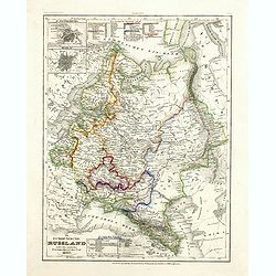
General karte vom europaischen Russland.
Rare second edition of a lithographed wall map of the European part of the Russian empire, at a scale of about 1:3,200,000. With the title in a elaborately decorated lett...
Date: Weimar, Geographisches Institut, 1840
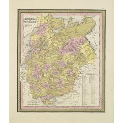
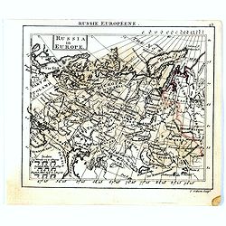
Russia in Europe.
From S. Augustus Mitchell’s "A New Universal Atlas". Philadelphia. Lithographic transfer from engraved plate. A fine map of Russia in Europe from the mid-nine...
- $80 / ≈ €70
Date: Philadelphia, c.1846

Kronstat From The Russian Survey . . .
Scarce chart of the Island of Kronstat, the primary defensive position for the Russian Navy in defense of Russia's Czarist Capital of St. Petersburg.Published on the eve ...
- $500 / ≈ €437
Date: London, 1853
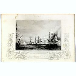
Bombardment of Odessa by the English and French April 22 1854, The boats of the British Fleet going to the French steamer 'Vauban' . . .
Scene from the Crimea war, showing the bombardment of Odessa, 22nd April 1854 (during Crimean War, 1853-56), engraving by G. Greatbach after drawing by H.W. Nicholls, c. ...
- $30 / ≈ €26
Date: London, 1855
Das Europäische Russland nebst den asiatischen Provinzen diesseit des Ural. 1849.
Detailed map of Russia, with inset plans of St. Petersburg and Moscow with extensive key to the different provinces. The map was according to a text revised in 1856.From ...
Date: Hildburghausen / Philadelphia 1856

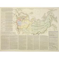
Exposé des travaux astronomiques en Russie (Atlas) with Supplément à l’exposé des travaux astronomiques et géodésiques exécutés en Russie contenant les noms, en langue russe de toutes les positions données au chapitre V (supplément I only).
Very rare atlas published to accompany Exposé des travaux astronomiques et géodésiques exécutés en Russie dans un but géographique jusqu’à l’année 1855. St.-P...
Date: St. Petersburg, Imperial Academy of Sciences: Eggers & Co., and Leipzig, Leopold Voss, 1858
![[Map of Grodno gubernia.]](/uploads/cache/81813-250x250.jpg)
[Map of Grodno gubernia.]
Карта Гродненско&...
- $450 / ≈ €393
Date: Sankt Peterburg, 1850-1900

Excelsiori (Rana N. 28 - Cent. 20).
"After so many wars and so many troubles, young Russia, in a more serene glaze all the beautiful sun of freedom you will enjoy ... ". Fascinating allegorical sa...
Date: Bologna, 1905
![Karta Evropeiskoi Rossii i Sibirii na 4 listakh [ Map of European Russia and Siberia in 4 sheets compiled and based on the most advanced statistical and geographical information.]](/uploads/cache/43927-250x250.jpg)
Karta Evropeiskoi Rossii i Sibirii na 4 listakh [ Map of European Russia and Siberia in 4 sheets compiled and based on the most advanced statistical and geographical information.]
A fine large map showing Eastern Europe from Stockholm to Constantinople, with Russia eastward from Perm and south to the Caucasus and Iran. With indications of judicial ...
- $750 / ≈ €655
Date: Saint Petersburg, 1908
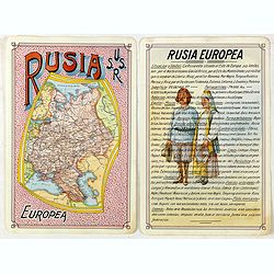
Rusia Europae U.S.S.R.
Detailed map of Russia. Unique manuscript map of Russia. Award-winning manuscript card, prepared by Antonio Raggio for the 11th Congreso de la Union Postal Universal (Wor...
- $450 / ≈ €393
Date: Buenos Aires, 1939
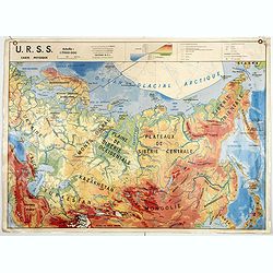
U.S.S.R. Carte Physique. / U.S.S.R. Carte Population.
An unusual school map with on one side a physical map of Russia on verso a map of Russia according to population. Prepared by Pierre Serryn (1916-2002) who was professor ...
- $200 / ≈ €175
Date: St-Germain-en-Laye, 1965
U.S.S.R. Carte Agricole. / U.S.S.R. Carte Industries et communications.
An unusual school map with on one side an agricultural map of Russia on verso a map of Russia showing communication an according to population. Prepared by Pierre Serryn ...
- $200 / ≈ €175
Date: St-Germain-en-Laye, 1965
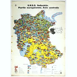
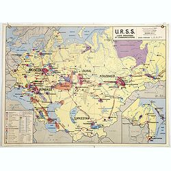
U.R.S.S. Industrie. Partie européenne, Asie centrale. (3)
Map of Eastern Russia. Propaganda poster for Russia's industry. Text in French. Editions de l'Agence de presse Novosti".More about War Maps & Propaganda maps [+]
- $100 / ≈ €87
Date: USSR, 1978
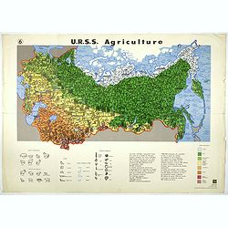
U.R.S.S. Agriculture. (6)
Map of Russia. Propaganda poster for Russia's in and export of industrial goods. With a key in bottom. Text in French. Editions de l'Agence de presse Novosti".More a...
- $100 / ≈ €87
Date: USSR, 1978
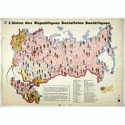
L'Union des Républiques socialistes Soviétiques. (2)
Map of Russia. Propaganda poster showing Russia' s population. With a key. Text in French. Editions de l'Agence de presse Novosti".More about War Maps & Propagan...
- $100 / ≈ €87
Date: USSR, 1978
