Browse Listings in Europe > Russia / Baltic / Black Sea region
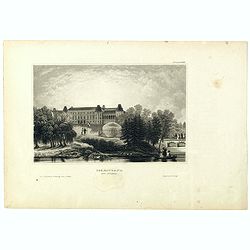
![[Untitled]. St. Petersburg.](/uploads/cache/37444-250x250.jpg)
[Untitled]. St. Petersburg.
A rare lithography published by Alexandre Ivanovitch Pluchard (1777-1832) in St.-Petersburg, one of the first lithographs made in St. Petersburg. The lithographs are publ...
- $400 / ≈ €349
Date: St.-Petersburg, 1827
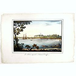
Le Palais imperial a Kamenoi Ostroff.
Fine lithography published by Alexandre Pluchart in St.-Petersburg, one of the first lithographs made in St. Petersburg. The lithographs are published in installments. Th...
- $450 / ≈ €393
Date: St.-Petersbourg, 1827
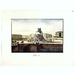
Pierre Ier.
A rare lithography published by Alexandre Ivanovitch Pluchard (1777-1832) in St.-Petersburg, one of the first lithographs made in St. Petersburg. The lithographs are publ...
- $500 / ≈ €437
Date: St.-Petersburg, 1827
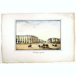
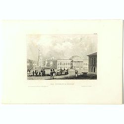
Bibliotheque imperiale.
Fine lithography published by Alexandre Ivanovitch Pluchard (1777-1832) in St.-Petersburg, one of the first lithographs made in St. Petersburg. The lithographs are publis...
- $450 / ≈ €393
Date: St.-Petersburg, 1827
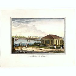
1ère habitation de Pierre 1er.
A rare lithography published by Alexandre Ivanovitch Pluchard (1777-1832) in St.-Petersburg, one of the first lithographs made in St. Petersburg. The lithographs are publ...
- $275 / ≈ €240
Date: St.-Petersburg, 1827
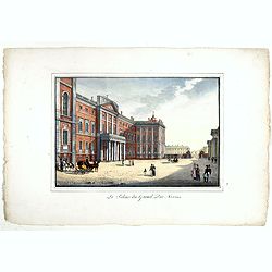
Le palais du Grand Duc Nicolas.
Fine and rare lithography published by Alexandre Ivanovitch Pluchard (1777-1832) in St.-Petersburg, one of the first lithographs made in St. Petersburg. The lithographs a...
- $750 / ≈ €655
Date: St.-Petersburg, 1827
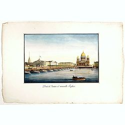
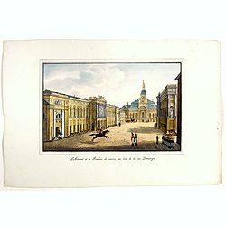
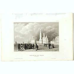
Pont d'Isaac et nouvelle Eglise.
A rare lithography published by Alexandre Pluchart in St.-Petersburg, one of the first lithographs made in St. Petersburg. The lithographs are published in installments. ...
- $500 / ≈ €437
Date: St.-Petersburg, 1827
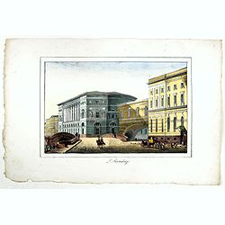
L'Hermitage.
A rare lithography published by Alexandre Pluchart in St.Petersburg, one of the first lithographs made in St. Petersburg. The lithographs are published in installments. T...
- $500 / ≈ €437
Date: St.Petersburg, 1827
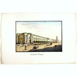
Les Grandes Boutiques.
Fine lithography published by Alexandre Ivanovitch Pluchard (1777-1832) in St.-Petersburg, one of the first lithographs made in St. Petersburg. The lithographs are publis...
- $400 / ≈ €349
Date: St.-Petersburg, 1827
Arsenal et la Fonderie de canons, au bout de la rue Litaiyana.
A rare lithography published by Alexandre Ivanovitch Pluchard (1777-1832) in St.-Petersburg, one of the first lithographs made in St. Petersburg. The lithographs are publ...
- $450 / ≈ €393
Date: St.-Petersburg, 1827
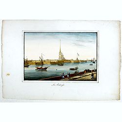
La Forteresse.
Fine lithography published by Alexandre Ivanovitch Pluchard (1777-1832) in St.-Petersburg, one of the first lithographs made in St. Petersburg. The lithographs are publis...
- $450 / ≈ €393
Date: St.-Petersburg, 1827
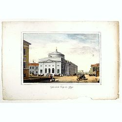
Eglise de la Vierge des Affligés.
A rare lithography published by Alexandre Ivanovitch Pluchard (1777-1832) in St. Petersburg, one of the first lithographs made in St. Petersburg. The lithographs are publ...
- $500 / ≈ €437
Date: St.-Petersburg, 1827
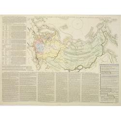
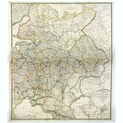
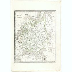
Tablaeu géographique statistique &C. de l'empire Russe actuel en Europe et en Asie avec ses aquisitions graduelles et caractérisées.
Map showing the extension of the Russian Empire at the beginning of the 19th century. Several letterpress notations are present on the map.Surrounding letterpress explana...
Date: Paris, Paul Renouard, 1828
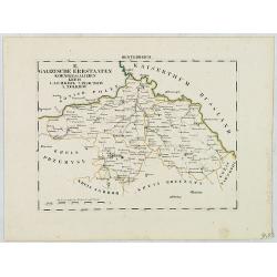
B. Galizische Erbstaaten Koenigr: Galizien Kreis 1. Lemberg 2. Zloczow 3. Zolkiew.
Map depict the western part of the Ukraine, centered on the town of Lviv (Lemberg) the former capital of the region of Galicia. Other cities are Zolkiew, Brody, Belz.From...
- $300 / ≈ €262
Date: Leipzig, G. J. Göschen, ca 1825-1830
![[No title] Russland.](/uploads/cache/28943-250x250.jpg)
[No title] Russland.
Map depict the area north of the Black Sea, including the cities of Odessa, Kischenau, Jelisawetgrad, Kherson.From "W. E. A. von Schliebens Atlas von Europa nebst Ko...
- $250 / ≈ €218
Date: Leipzig, G. J. Göschen, ca 1825-1830
![[No title] Russland.](/uploads/cache/28944-250x250.jpg)
[No title] Russland.
Map depict the area north of the Black Sea, including the cities of Jekaterinoslaw, Bachmut, Alexandrowsk.From "W. E. A. von Schliebens Atlas von Europa nebst Koloni...
- $300 / ≈ €262
Date: Leipzig, G. J. Göschen, ca 1825-1830
![[No title] Oesterreich. B. Galizische erbstaaten Koenigr. Galizien Kreis 12. Sambor 13. Stry 17. Stanislawow.](/uploads/cache/28948-250x250.jpg)
[No title] Oesterreich. B. Galizische erbstaaten Koenigr. Galizien Kreis 12. Sambor 13. Stry 17. Stanislawow.
Map depict the area north of the Black Sea, including the cities of Stanislawow, Drobicz, Sambor.From "W. E. A. von Schliebens Atlas von Europa nebst Kolonien für G...
- $300 / ≈ €262
Date: Leipzig, G. J. Göschen, ca 1825-1830
![[No title] Russland. Gouv. 24 Woronesh 28. Slobodsk Ukraine.](/uploads/cache/28949-250x250.jpg)
[No title] Russland. Gouv. 24 Woronesh 28. Slobodsk Ukraine.
Map depict the area north of the Black Sea, including the cities of Kharkow, Achtyrka, Woronesh, etc.From "W. E. A. von Schliebens Atlas von Europa nebst Kolonien f�...
- $300 / ≈ €262
Date: Leipzig, G. J. Göschen, ca 1825-1830
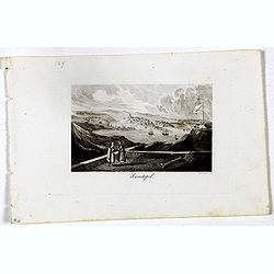
Sewastopol. (Sebastopol)
View of Sebastopol. Engraved by Leopold Zechmayer who was active in Vienna.
- $20 / ≈ €17
Date: Vienna, ca. 1835
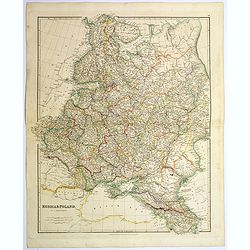
Russia & Poland.
A glorious, large steel engraved map of Russia and Poland. Covering Poland and Finland in the west, as far south as to the very edges of Persia, the Black sea, and to the...
Date: London, 1839
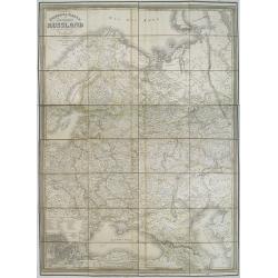
General karte vom europaischen Russland.
Rare second edition of a lithographed wall map of the European part of the Russian empire, at a scale of about 1:3,200,000. With the title in a elaborately decorated lett...
Date: Weimar, Geographisches Institut, 1840
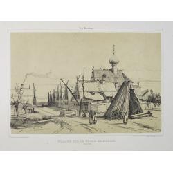
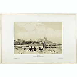
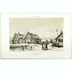
Village sur la route de Moscou. (9 Août 1839).
A view of a village on the way to Saint Petersburg on August 9 1839. Plate taken from the first illustrated account of Russian architecture. This publication was the proj...
Date: Paris, 1842
The Russian Dominions in Europe ... with the Post Roads & New Governments from the Russian Atlas of 1806 by Jasper Nantiat.
A two-sheet wall map of Russia covering from the Artic Sea to the Black and Caspian Seas and from East Prussia and Moldova to the Aral Sea and Tobolsk. Modern day nations...
- $500 / ≈ €437
Date: London, ca. 1843
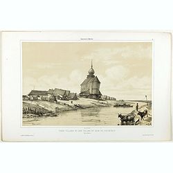
Vieux village et son église en bois du XIIIe siècle près de Rostow.
A view of an old village and its church. Figures are lithographed by Raffet. Plate taken from the first illustrated account of Russian architecture. This publication wa...
- $100 / ≈ €87
Date: Paris, 1844
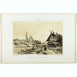
Village entre Novgorod et Tver.
A view of a village between Novgorod and Tver, as on 12 of August 1839. River Volga on foreground. Figures are lithographed by Raffet. Plate taken from the first illustra...
- $150 / ≈ €131
Date: Paris, 1844
Vue de côté merodional.
A view of the village Vladimir. Figures are lithographed by Raffet. Plate taken from the first illustrated account of Russian architecture. This publication was the proje...
- $150 / ≈ €131
Date: Paris, 1844
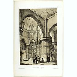
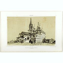
Intérieur de l'église du Monastère de la Ste Trinité.
A view of the Ste Trinity Monastery. Figures are lithographed by Raffet. Plate taken from the first illustrated account of Russian architecture. This publication was the ...
- $100 / ≈ €87
Date: Paris, 1844
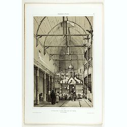
Intérieur d'une église en bois, près de Kineschma.
A view of a church's inside, made of wood. Figures are lithographed by Raffet. Plate taken from the first illustrated account of Russian architecture. This publication wa...
- $100 / ≈ €87
Date: Paris, 1844
The church of Vasili Blagennoi Moscow.
Original steel engraving of St. Basil's Cathedral in Moscow, after a design by Alfred Gomersal Vickers (1810-1837) engraved by James Harfield Kernot (1802-1858).
- $20 / ≈ €17
Date: London and Paris, 1844
Village de Goumnisthe entre Kostroma et Yaroslaw..
A view of Goumnisthe village. Figures are lithographed by Raffet. Plate taken from the first illustrated account of Russian architecture. This publication was the project...
Date: Paris, 1844
Eglise des saintes femmes.
A view of a church, the 5 of September 1839. Figures are lithographed by Raffet. Plate taken from the first illustrated account of Russian architecture. This publication ...
Date: Paris, 1844
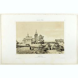
Nikolskoï paroisse entre les villes de Soudogda et Mouroum.
A view of an old church. Figures are lithographed by Raffet. Plate taken from the first illustrated account of Russian architecture. This publication was the project of C...
- $150 / ≈ €131
Date: Paris, 1844
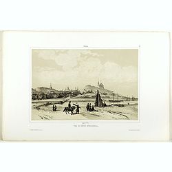
Vue du côté méridional.
A view of an old village. Figures are lithographed by Raffet. Plate taken from the first illustrated account of Russian architecture. This publication was the project of ...
- $150 / ≈ €131
Date: Paris, 1844
The church of Vasili Blagennoi Moscow.
Steel engraving of St. Basil's Cathedral in Moscow, after a design by Alfred Gomersal Vickers (1810-1837) engraved by James Harfield Kernot (1802-1858).
Date: London, 1844
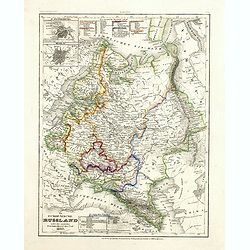
Russie d'Europe.
Detailed map of European Russia, prepared by Charles V. Monin (fl.1830-1880) a French cartographer of Caen and Paris. Published in Atlas Universel de Géographie Ancienne...
- $25 / ≈ €22
Date: Paris, 1845
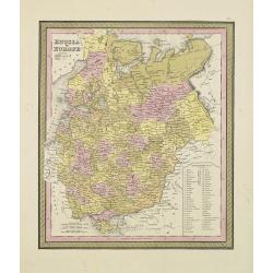
Russia in Europe.
From S. Augustus Mitchell’s "A New Universal Atlas". Philadelphia. Lithographic transfer from engraved plate. A fine map of Russia in Europe from the mid-nine...
- $80 / ≈ €70
Date: Philadelphia, c.1846
![[Untitled map of Black Sea].](/uploads/cache/37349-250x250.jpg)
[Untitled map of Black Sea].
Very detailed and rare map of Black Sea region. The map has elaborate floral borders. Prepared by Joseph Scheda in Vienna.
- $200 / ≈ €175
Date: Vienna, 1845-1847
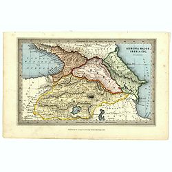
Armenia major, Iberia etc. by J.Archer.
Early Missionary map of Armenia from the "Atlas of educational maps for the use of schoolmasters" (1847), published by SPCK - the Society for Promoting Christia...
- $150 / ≈ €131
Date: London, 1847
Czaritzana bei Moskau. (Tsaritsyno In Moscow)
Steel engraving with a panoramic view of the Tsaritsyn Palace In Moscow, published in "Meyers Universum oder Abbildung und Beschreibung des Sehenswerthesten und Merk...
- $20 / ≈ €17
Date: Hildburghausen, 1848
Das Zeughaus in Moscau.
Steel engraving of the Kremlin, published in "Meyers Universum oder Abbildung und Beschreibung des Sehenswerthesten und Merkwürdigsten der Natur und Kunst auf der g...
- $25 / ≈ €22
Date: Hildburghausen, 1848
Kloster des Ivan Velekoi in Moscau.
Steel engraving of the Kremlin, published in "Meyers Universum oder Abbildung und Beschreibung des Sehenswerthesten und Merkwürdigsten der Natur und Kunst auf der g...
- $25 / ≈ €22
Date: Hildburghausen, 1848
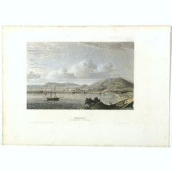
Kertsch im südlichen Russland. (Kerch)
Steel engraving with a panoramic view of the town of Krech, published in "Meyers Universum oder Abbildung und Beschreibung des Sehenswerthesten und Merkwürdigsten d...
- $15 / ≈ €13
Date: Hildburghausen, 1848

Zarskoe. (Tsarskoye Selo)
Steel engraving with a panoramic view of the town of Zarskoe, published in "Meyers Universum oder Abbildung und Beschreibung des Sehenswerthesten und Merkwürdigsten...
- $20 / ≈ €17
Date: Hildburghausen, 1848
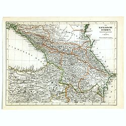
Der Kaukasische Istmus . . .
Detailed contemporary colored map of the countries of the Caucasus Mountains. Steel engraving appeared in "Meyer's Lexicon. Atlas der Geographie". Engraved by C...
Date: Hildburghausen, 1849
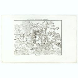
Plan du Champ de Bataille de la Moskowa
Prepared by Thunot Duvotenay (1796-1875), a French geographer and publisher. Detailed map taken from: "Thiers, Atlas de l' Histoire du Consulat et de l' Empire"...
- $150 / ≈ €131
Date: Paris, 1850
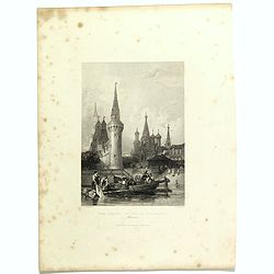
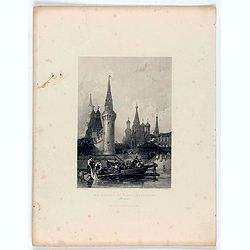
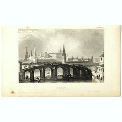
Der Kreml in Moscau.
View of Moscow with in the background the Kremlin. Original steel engraving, published by Bibliographisches Institut Hildburghausen. Engraved by H.Hauser.
- $30 / ≈ €26
Date: Hildburghausen, 1850
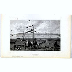
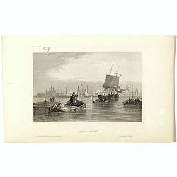
Taganrog in Russland
View of Tarangow. Original steel engraving, published by Bibliographisches Institut Hildburghausen. Engraved by E.Willmann.
Date: Hildburghausen, 1850
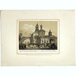
Eglise de Notre Dame de Vladimir.
The church of Holy Mary in Vladimi with in the foreground a ceremony with bishops, monks and faithful viewers. Below a caption in French and in Cyril.
- $45 / ≈ €39
Date: Russia or France, ca. 1850
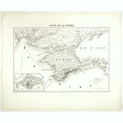
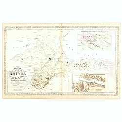
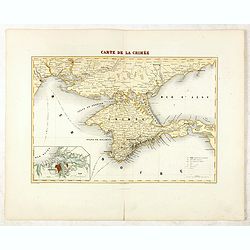
Carte de la Crimée.
Attractive map of Crimea with inset plan of Sevastopol, prepared by Alexandre Aimé Vuillemin (1812-1886). A road system and the ferry lines are drawn in.Engraved by Jaco...
- $150 / ≈ €131
Date: Paris, ca. 1850
Moscau von der Kreml-Seite.
Steel engraving with a panoramic view of the Kremlin in Moscow, published in "Meyers Universum oder Abbildung und Beschreibung des Sehenswerthesten und Merkwürdigst...
- $20 / ≈ €17
Date: 1850
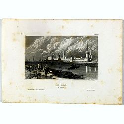
Archangel.
Steel engraving of Archangel, published by the German publishing company Bibliographisches Institut which was founded 1826 in Gotha by Joseph Meyer, moved 1828 to Hildbur...
- $25 / ≈ €22
Date: Hildburghausen, 1850
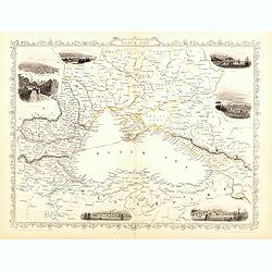
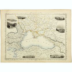
Black Sea.
Decorative steel engraved map of the Black Sea with inset views of Sebastopol and Odessa. There are also vignettes of Constantinople, Sinope and Varna. Taken from "T...
- $110 / ≈ €96
Date: London, London Printing and publishing Company of London, ca. 1851
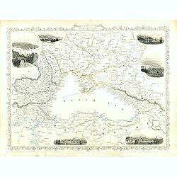
Black Sea.
Decorative steel engraved map of the Black Sea with inset views of Sebastopol and Odessa. There are also vignettes of Constantinople, Sinope and Varna. Taken from "T...
Date: London, London Printing and publishing Company of London, ca. 1851
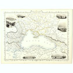
Black Sea.
Decorative steel engraved map of the Black Sea with inset views of Sebastopol and Odessa. There are also vignettes of Constantinople, Sinope and Varna. Taken from "T...
- $90 / ≈ €79
Date: London, London Printing and publishing Company of London, ca. 1851
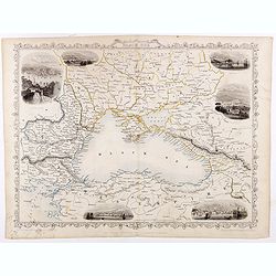
Black Sea.
Decorative steel engraved map of the Black Sea with inset views of Sebastopol and Odessa. There are also vignettes of Constantinople, Sinope and Varna. Taken from "T...
- $90 / ≈ €79
Date: London, London Printing and publishing Company of London, ca. 1851
Black Sea.
Decorative steel engraved map of the Black Sea with inset views of Sebastopol and Odessa. There are also vignettes of Constantinople, Sinope and Varna. Taken from "T...
Date: London, London Printing and publishing Company of London, ca. 1851

Black Sea.
Decorative steel engraved map of the Black Sea with inset views of Sebastopol and Odessa. There are also vignettes of Constantinople, Sinope and Varna. Taken from "T...
Date: London, London Printing and publishing Company of London, ca. 1851

Kronstat From The Russian Survey . . .
Scarce chart of the Island of Kronstat, the primary defensive position for the Russian Navy in defense of Russia's Czarist Capital of St. Petersburg.Published on the eve ...
- $500 / ≈ €437
Date: London, 1853
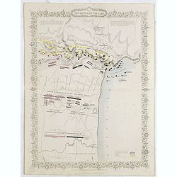
Plan of the battle of Alma.
An antique plan drawn and engraved by John Rapkin "from English and French Official Documents" Published 1858 by the London Printing and Publishing Co., London....
Date: London, 1854
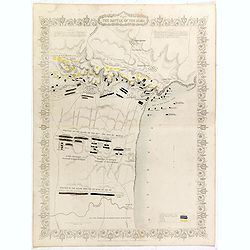
Plan of the battle of Alma.
Fine plan drawn and engraved by John Rapkin "from English and French Official Documents" Published 1858 by the London Printing and Publishing Co., London. Shows...
- $150 / ≈ €131
Date: London, 1854
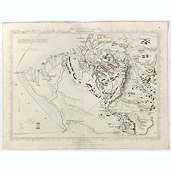
Siege of Sebastopol.
Detailed map of the Siege of Sebastopol. After the Battle of the Alma, the Allies proceeded to Sebastopol and commenced the Siege on September 26th, 1854. This is a steel...
- $150 / ≈ €131
Date: London, 1854
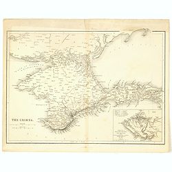
The Crimea.
Map of Crimea and the Sea of Azov. In lower right corner inset map showing Sebastopol region.
- $50 / ≈ €44
Date: London, 1854
Positions occupées par les armées françaises et anglaises devant Sevastopol.
Map of the French and English armies positions in Sebastopol.Read more about The Crimean War - The Siege of Sevastopol. [+]
- $350 / ≈ €306
Date: Paris, 1854
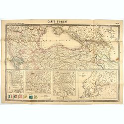
Carte d'Orient par Kraminski ingénieur.
Large map of Orient, with an insert of four maps (Constantinople plan - Map of Europe - Map of Russia - Plan of Baltic sea). With flags in the lower left part. color key ...
Date: Paris, 1854
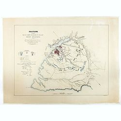
Accampamenti, Trinceramenti, ed Operazioni di Assedio...
Detailed plan of the Allied siege of Sebastopol in 1854-1855 during the Crimean War, showing the allied French, English and Turkish positions, and those of the Russians, ...
- $400 / ≈ €349
Date: Naples, 1855
Bombardment of Odessa by the English and French April 22 1854, explosion on the imperial mole . . .
Scene from the Crimea war, showing a bombardment of Odessa, 22nd April 1854 (during Crimean War, 1853-56), by English and French forces, explosion imperial mole (breakwat...
- $55 / ≈ €48
Date: London, 1855
Bombardment of Odessa by the English and French April 22 1854, The boats of the British Fleet going to the French steamer 'Vauban' . . .
Scene from the Crimea war, showing the bombardment of Odessa, 22nd April 1854 (during Crimean War, 1853-56), engraving by G. Greatbach after drawing by H.W. Nicholls, c. ...
- $30 / ≈ €26
Date: London, 1855
A Complete Map of the Crimea Showing the Military and Carriage Roads with Distances from Various Points of the Western Coast From English & Russian Surveys. . .
Uncommon map of Crimea with (inset maps) Sebastopol Harbor, and Map Showing the relative Position of the Crimea with the Seat of War. From Desilver's "A New Universa...
- $300 / ≈ €262
Date: Pennsylvania, ca. 1856
Das Europäische Russland nebst den asiatischen Provinzen diesseit des Ural. 1849.
Detailed map of Russia, with inset plans of St. Petersburg and Moscow with extensive key to the different provinces. The map was according to a text revised in 1856.From ...
Date: Hildburghausen / Philadelphia 1856
Kriegs- und Spezialkarte vom Finnischen Meerbusen von Kronstadt bis St. Petersburg 1856.
Interesting and detailed map with Kronstadt on the left and St. Petersburg on the right. In the center is information about the war and the listing of some major monument...
- $40 / ≈ €35
Date: Hildburghausen, 1856
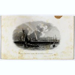
Taking soundings under the batteries of Cronstadt.
Steel engraving showing a small boat taking soundings under the batteries of Kronstadt from a drawing by J. W. Carmichael, engraved by E. Brandard. From "The History...
- $20 / ≈ €17
Date: London, Virtue, ca. 1857
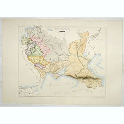
Provincia ecclesiastica di Mohilow nell' Impero Russo (Tav XCII)
A large-format map of Russia, Georgie, Black Sea region with its different dioceses. The map is finely engraved and beautifully colored and was prepared by Girolamo Petri...
- $400 / ≈ €349
Date: Rome, 1858
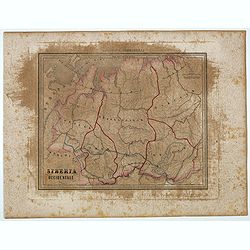
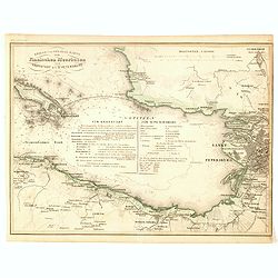
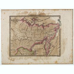
Siberia Occidentale.
Uncommon map of Siberia prepared by Francesco Costantino Marmocchi. Above the map "Geografia Commerciale". From "Il Globo Atlante di carte Geografiche comp...
- $50 / ≈ €44
Date: Genova, Paolo Rivara fu Giacomo, 1858
La Siberia Orientale.
Uncommon map of Oriental Siberia prepared by Francesco Costantino Marmocchi. Above the map "Geografia Commerciale". From "Il Globo Atlante di carte Geograf...
- $50 / ≈ €44
Date: Genova, Paolo Rivara fu Giacomo, 1858

Exposé des travaux astronomiques en Russie (Atlas) with Supplément à l’exposé des travaux astronomiques et géodésiques exécutés en Russie contenant les noms, en langue russe de toutes les positions données au chapitre V (supplément I only).
Very rare atlas published to accompany Exposé des travaux astronomiques et géodésiques exécutés en Russie dans un but géographique jusqu’à l’année 1855. St.-P...
Date: St. Petersburg, Imperial Academy of Sciences: Eggers & Co., and Leipzig, Leopold Voss, 1858
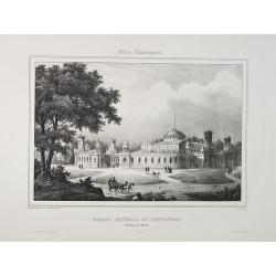
Palais Impérial de Petrowski. Environs de Moscou. N° 17.
Decorative view of the Imperial Palace of Petrowski. After a design by Vander Burch. Printed by L.Turgis active in Paris and New York. Turgis is best known for his series...
- $200 / ≈ €175
Date: Paris, ca. 1850-1860

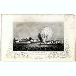
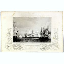
L'escadre alliée bombarde les forts extérieurs de Sébastopol. (18 octobre 1854)
Beautiful Crimean War lithography by Becquet after a painting by Louis Le Breton. The print illustrates the ships "Fort Constantin", "la ville de Paris&quo...
Date: Paris, 1860
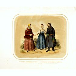
Race Finnoise. Paysans du gouvernement d'Olonetz districts de Petrozavodsk et de Vytiagorsk.
Lithography on tinted grounds printed by Lemercier in Paris and published by Velten in St. Petersburg.
- $100 / ≈ €87
Date: Paris, St. Petersburg, Carlsruhe, c.1860

Race Finnoise. = Paysans du gouvernement d'Olonetz districts de Petrozavodsk et de Vytiagorsk.
People in local dress from Petrozavodsk region in Russia. Lithography on tinted grounds printed by Lemercier in Paris and published by Velten in St. Petersburg.
- $150 / ≈ €131
Date: Paris, St. Petersburg, Carlsruhe, c.1860
Carte de la Crimée / dressée par A. Vuillemin.
Attractive map of Crimea with inset plan of Sevastopol, prepared by Alexandre Aimé Vuillemin (1812-1886). A road system and the ferry lines are drawn in.Engraved by Jaco...
- $300 / ≈ €262
Date: Paris, ca. 1860
