Browse Listings
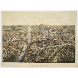
Angers 1878.
Large bird's-eye view of Angers after Mollay and lithographed by Muller.
- $250 / ≈ €215
Date: Paris, Lemercier, ca. 1878
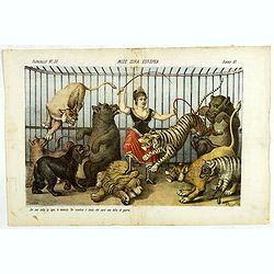
Miss Cora Europea. Papagallo No. 35. Anno VI.
Miss Europa taming the lion (Russia) with other nations shown as animals. Design by Augusto Grossi. Taken from the Italian satirical newspaper Il Papagallo, a satirical m...
Date: Bologne, 1878
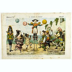
Il bolero in Ispagnia. Papagallo No. 42. Anno VI.
About Spanish expansion, with balloons symbolizing Cuba, Havana, Cortes. Taken from the Italian satirical newspaper Il Papagallo, a satirical magazine founded in January ...
Date: Bologne, 1878
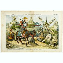
Il Don Cihsciotte a complici. Papagallo No. 48. Anno VI.
Taken from the Italian satirical newspaper Il Papagallo, a satirical magazine founded in January 1873 by Augusto Grossi (1835-1919), which specialized in color-printed ca...
Date: Bologne, 1878
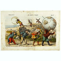
Pesi Graditi ee sgraditi. Papagallo No. 6. Anno VI.
Translation of the legend: "Several weights, each one has to carry its weight, the more serious it is, the longer the trip seems to be, and they will come sooner or ...
Date: Bologne, 1878
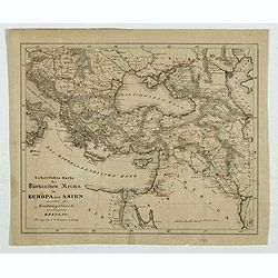
Karte des Türkischen Reiches in Europa und Asien . . .
Map of Turkish Empire.
- $35 / ≈ €30
Date: Breslau, 1878

Un Reclutatore in India. Papagallo No. 42. Anno VI.
British in India. Design by Augusto Grossi. Taken from the Italian satirical newspaper Il Papagallo, a satirical magazine founded in January 1873 by Augusto Grossi (1835-...
Date: Bologne, 1878
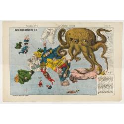
La Piovra Russa. Carta Serio-Comica Pel 1878.
Variant of the very rare political caricature map by Grossi of the nations of Europe, published in Bologna in the supplement of the newspaper "Le Perroquet / Al papa...
Date: Bologne presso il Giornale colorato in Papagallo, 1878
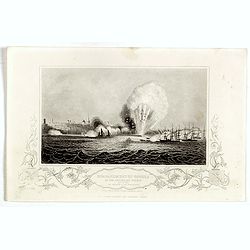
Bombardment of Odessa by the English and French April 22 1854, explosion on the imperial mole . . .
Scene from the Crimea war, showing a bombardment of Odessa, 22nd April 1854 (during Crimean War, 1853-56), by English and French forces, explosion imperial mole (breakwat...
- $30 / ≈ €26
Date: London, ca. 1879

Le Lapin.
Nice etching by Ch. Waltner after a painting of Manet.
- $20 / ≈ €17
Date: Paris, 1879
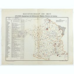
Recensement de 1877. Situation Géographique des Etablissements Religieux d'Hommes non Autorisés.
Rare map showing private secondary schools for boys created by unauthorized religious congregations. On sale at M. Devillaire, 43, R. du Four St. Germain in Paris / at M....
Date: Paris, F. Appel, 1879
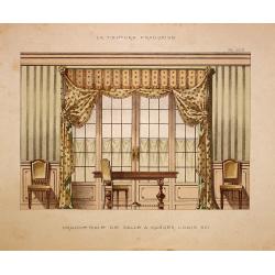
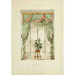
Grande baie de salle a manger Louis XVI.
Very decorative and colorful lithography of an elegant French interior. From La Tenture Française, published by G.MathiÞre, 32/34 Rue de Charonne, Paris.
- $75 / ≈ €65
Date: Paris, 1880
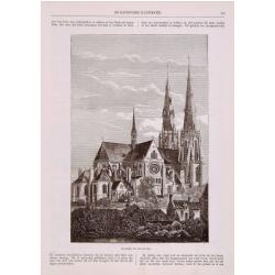
Sint Catharinakerk te Eindhoven
Uncommon print of St.Catharina church of Eindhoven, built by the well-known architect P.Cuijpers. Published in Katholieke Illustratie .
- $85 / ≈ €73
Date: 'sHertogenbosch, 1880
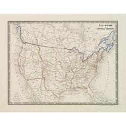
États-Unis et Nouvelle Bretagne.
A detailed map of the United States. All different States are divided by an orange border line.
- $120 / ≈ €103
Date: Paris, 1880
![[Title page] La France Nouvel Atlas illustré des Départements & des Colonies . . .](/uploads/cache/17248-250x250.jpg)
[Title page] La France Nouvel Atlas illustré des Départements & des Colonies . . .
Title page from a French atlas, the decoration executed in Neo-Gothic style. In bottom part a globe and a map of France, to the left an Atlas-figure.Engraved by Villerey.
- $30 / ≈ €26
Date: Paris, 1880

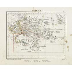
Océanie.
Decorative map of the Pacific Ocean including Indonesia, Australia, New Zealand and California. Lower right inset map Détails de la Nouvelle Galles Méridionale , includ...
- $120 / ≈ €103
Date: Paris 1880
Océanie.
Small map of Australia, New Zealand and the Pacific. The area is divided in different parts. Lithographed by C.Callewaert from Brussels.
- $80 / ≈ €69
Date: Bruxelles, c. 1880
![Sint-Catharinakerk te Eindhoven [with plan]](/uploads/cache/28813-250x250.jpg)
Sint-Catharinakerk te Eindhoven [with plan]
Uncommon wood engraved print of St.Catharina church in Eindhoven, built by the well-known architect P.Cuijpers. Published in Kunstkronijk. This wood engraving is similar ...
- $85 / ≈ €73
Date: Amsterdam, c.1880

Kasteel Croij.
Decorative lithography of the castle of Croij.
Date: Den Haag, 1880
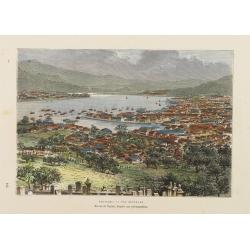
Nagasaki. - Vue générale. Dessin de Taylor, après une photographie.
A bird's-eye view showing Nagasaki Bay. After a photograph by Taylor. Engraved in wood by A.Kohl.Showing the town and natural harbour of Nagasaki.In the harbour the islan...
- $150 / ≈ €129
Date: Paris, 1880
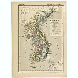
Carte de la Corée d'après la Carte du Dictionnaire coréen-français par les Missionnaires de Corée. . .
Map of Korea called "Corée", which was produced by the French organization Mission Etrangères de Paris (MEP) in 1880. Supposedly, the map was based on Father ...
Date: Paris, 1880
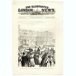
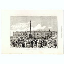
The attempt on the Czar's life: the Soltykoff dorway of the Winter Palace . . .
A panorama of the Winter Palace published in the Illustrated London News of 1880.
- $20 / ≈ €17
Date: London, 28 February, 1880
The attempt on the Czar's life: The Winter Palace, St Petersburg.
A panorama of the Winter Palace with an attempt on the Czar's life published in the Illustrated London News of 28 February, 1880.
- $15 / ≈ €13
Date: London, 28 February, 1880
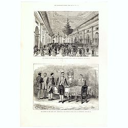
The attempt on the Czar's life: The Grand Ball-Room . . .
A panorama of the Winter Palace with an attempt on the Czar's life published in the Illustrated London News of 28 February, 1880.
- $15 / ≈ €13
Date: London, 28 February, 1880
Porte Ste Barbe.
View of the gate of St. Barbe. Title in Russian and French.
- $50 / ≈ €43
Date: Russia, ca. 1880
Bataille de la Moskova.
Etching of a battle in which Napoleon's army fought the Russian army of general Kutuzov on 7 September 1812.Etched by Auguste II. Boulard (1852–1927) after a painting b...
- $50 / ≈ €43
Date: Paris, 1880
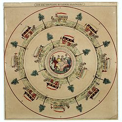
Jeu des omnibus et dames blanches.
The name of 'Dames Blanches', or white ladies, was bestowed on the two-compartment public omnibus that plied the Madeleine-Bastille run in Paris. In 1937 the brand Hermè...
- $250 / ≈ €215
Date: Paris, ca 1880
![Jules Verne Le Tour du Monde en 80 jours. [Goose game board inspired by Jules Verne's novel Tour du Monde en 80 jours.]](/uploads/cache/44919-250x250.jpg)
Jules Verne Le Tour du Monde en 80 jours. [Goose game board inspired by Jules Verne's novel Tour du Monde en 80 jours.]
Goose game board inspired by Jules Verne's novel, whose boxes are illustrated with color lithographs and the center occupied by a world map. Vignette illustrations number...
Date: Paris, ca. 1880
![[ A set of four humorous illustrations 'Le Malade Imaginaire'.]](/uploads/cache/46323-250x250.jpg)
[ A set of four humorous illustrations 'Le Malade Imaginaire'.]
A humorous illustration from the "Le Malade Imaginaire" - numbers 68. Shows a smiling, frothing syringe, with hands-on hips surrounded by dancing witches. Small...
Date: Paris, ca. 1880
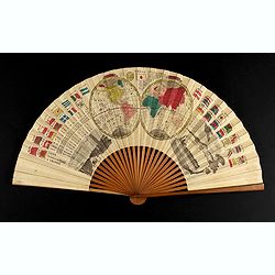
A folding fan with a map of Japan, double hemisphere world map and views of Yokohama and Edo.
The folding fan showing a map of Japan on one side, and on the other side a double hemisphere world map, two city views, and a train. Read more about folding fans andcar...
- $750 / ≈ €646
Date: Japan, ca. 1880
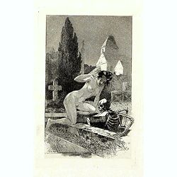
![Fantaisie Funebre [ Funeral Fantasy.]](/uploads/cache/46336-250x250.jpg)
Fantaisie Funebre [ Funeral Fantasy.]
With text below the illustration "-Qui, parlons-en: vous faites un malade bien agréable... j'voudrais... qu'vous n'ayez personne à votre enterrement ! Design by Le...
- $80 / ≈ €69
Date: Paris, ca. 1880
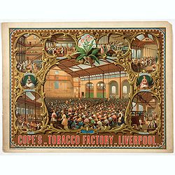
Cope's Tobacco Factory Liverpool.
The company was started in 1848 in Old Post Office Street Liverpool by Thomas Cope and George Cope. By the 1880s the company was employing nearly 2000 staff and producing...
- $750 / ≈ €646
Date: Paris, 1880

Marine parallel rulers in brass.
Very fine marine parallel rulers in brass. The parallel ruler is the oldest and most traditional way to measure and trace routes and bearings. The principle is simple: t...
Date: Paris, ca. 1880

Transom of a ship in gilded carved wood bearing the inscription "DUMONT- DURVILLE"
Decorative transom sign in gilded carved wood bearing the inscription "DUMONT- DURVILLE" in a foliage environment. The transom usually kept the name of the ship...
Date: France, ca. 1880
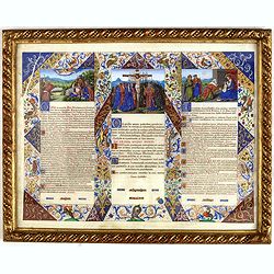
Canon Altar.
Each panel is handwritten in red and black ink, with beautiful golden blue or red initials; it is part of a rich and beautiful gouache and gold polychrome frame foliage f...
Date: ca. 1880
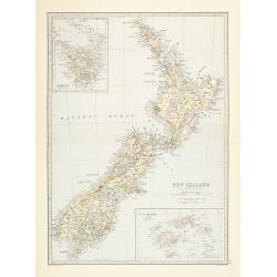
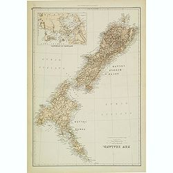
New Zealand.
Very detailed map of New Zealand, with inserts of Tasmania and Fiji Islands. The map was printed from lithographic stones taken from a hand-engraved steel plate. The cart...
Date: Edinburg, ca 1881
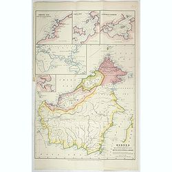
Borneo, shewing the lands ceded by the sultans of Brunei & Sulu to the British North Borneo Company.
Chromo lithographed folded map showing Borneo with Brunei, Sarawak, British North Borneo Company or Sabah. One of the first maps showing the British North Borneo Company ...
- $1750 / ≈ €1507
Date: London, Stanford, 1881
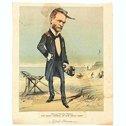
William Tecuseh Sherman The Great General of our small army.
Illustration of General William T. Sherman, full-length portrait, standing, facing right, holding binoculars, his sword resting on a campstool behind him. Published in Ne...
- $100 / ≈ €86
Date: New York, 1881
Fenètre et siège empire.
Very decorative and colorful lithography of an elegant French interior. From La Tenture Française, published by G.Mathière, 32/34 Rue de Charonne, Paris.
- $50 / ≈ €43
Date: Paris, 1882
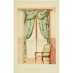
Baie Louis XVI. . .
Very decorative and colorful lithography of an elegant French interior. From La Tenture Française published by G.Mathière, 32/34 Rue de Charonne, Paris.
Date: Paris, 1882
![Hong Kong. [Queen's Road]](/uploads/cache/24362-250x250.jpg)
Hong Kong. [Queen's Road]
Finely executed watercolor made by Henri Dieth of a charming atmospheric street scene at Queen's Road in Hong Kong. The watercolor is made after Eduard Hildebrandt (1818-...
Date: Germany, 1882
![Hongkong Piratenstrasse. [Pirate Street]](/uploads/cache/24363-250x250.jpg)
Hongkong Piratenstrasse. [Pirate Street]
Finely executed watercolor made by Henri Dieth of a charming street scene at "Pirate Street" in Hong Kong. The watercolor is made after Eduard Hildebrandt (1818...
Date: Germany, 1882

Runde Strasse in Peking.
Finely executed watercolor made by Henri Dieth of a charming street scene in Peking. The watercolor is made after Eduard Hildebrandt (1818-1869). Hildebrandt, was born in...
Date: Germany, 1882
New Zealand (with Environs of Auckland)
Striking map of New Zealand, with a large inset map of the environs of Auckland. Made by J. Bartholomew. NO. 66 in lower right corner.
- $200 / ≈ €172
Date: Glasgow, London, 1882
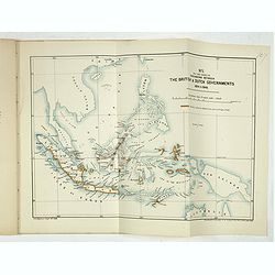
Papers relating to the affairs of Sulu and Borneo, and to the grant of a charter of incorporation of the British North Borneo Company. . . (with two folding maps of Indonesia)
58 pages Government recordings relating to the affairs of Sulu and Borneo, and to the grant of a charter of incorporation of the British North Borneo Company. . . (includ...
- $500 / ≈ €430
Date: London, Harrison and son, 1882
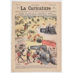
Enquête sur l'état de la civilisation en Europe. (Front page of la Caricature n°140).
The newspaper contains eight pages with different illustration. The artist is A. Robida, who was the chief editor and the engraver is Yves BarretThe artist is A. Robida, ...
- $100 / ≈ €86
Date: Paris, La Caricature, September 2, 1882
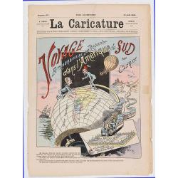
Voyage extraodinaire d'un reporter dans l'Amérique du Sud par Clérice (Front page of la Caricature n°137).
Frontispiece showing a globe with south America and the title "Voyage extraodinaire d'un reporter dans l'Amérique du Sud par Clérice". The newspaper contains ...
- $150 / ≈ €129
Date: Paris, La Caricature, August 12, 1882

Dutton Map of the Grand Canyon, Arizona (in 4 joined sheets)
An important 1882 map of the Grand Canyon, Arizona, published in "Atlas To Accompany The Monograph On The Tertiary History Of The Grand Canon District By Capt. Clare...
Date: Julius Bien and Co., 1882
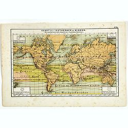
Hypsometrisch Overzicht der Aarde.
One of the earliest thematic world maps published in the Netherlands from "Atlas der natuurkundige aardrijkskunde. . .". prepared by Nicolaas Wilhelmus Posthumu...
- $50 / ≈ €43
Date: Amsterdam, C.L. Brinkman, 1883
Oro-Hydrographische Kaart van Europa.
One of the earliest thematic maps of Europe published in the Netherlands from "Atlas der natuurkundige aardrijkskunde. . .". prepared by Nicolaas Wilhelmus Post...
- $35 / ≈ €30
Date: Amsterdam, C.L. Brinkman, 1883

Oro-Hydrographische Kaart van Azië.
One of the earliest thematic maps of Asia published in the Netherlands from "Atlas der natuurkundige aardrijkskunde. . .". prepared by Nicolaas Wilhelmus Posthu...
- $35 / ≈ €30
Date: Amsterdam, C.L. Brinkman, 1883
Geologische Kaart van Middel- en Zuid-Europa.
One of the earliest thematic maps published in the Netherlands from "Atlas der natuurkundige aardrijkskunde. . .". prepared by Nicolaas Wilhelmus Posthumus. Wit...
- $35 / ≈ €30
Date: Amsterdam, C.L. Brinkman, 1883
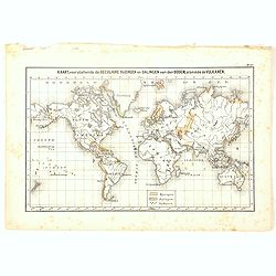
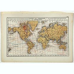
Kaart, voorstellende de Seculaire Rijzingen en Dalingen van den Bodem, alsmede de Vulkamen.
One of the earliest thematic world maps published in the Netherlands from "Atlas der natuurkundige aardrijkskunde. . .". prepared by Nicolaas Wilhelmus Posthumu...
- $35 / ≈ €30
Date: Amsterdam, C.L. Brinkman, 1883
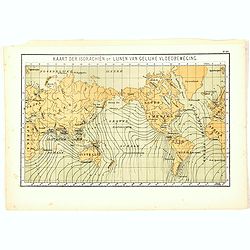
Kaart der Isorachiën of Lijnen van Gelijke Vloedbeweging.
One of the earliest thematic world maps published in the Netherlands from "Atlas der natuurkundige aardrijkskunde. . .". prepared by Nicolaas Wilhelmus Posthumu...
- $35 / ≈ €30
Date: Amsterdam, C.L. Brinkman, 1883
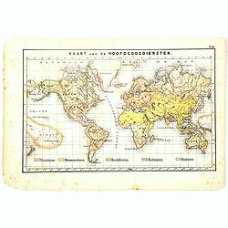
Kaart van de Hoofdgodsdiensten.
One of the earliest thematic world maps published in the Netherlands from "Atlas der natuurkundige aardrijkskunde. . .". prepared by Nicolaas Wilhelmus Posthumu...
- $35 / ≈ €30
Date: Amsterdam, C.L. Brinkman, 1883
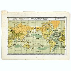
Kaart der Oceanische Stroomgebieden.
One of the earliest thematic maps published in the Netherlands from "Atlas der natuurkundige aardrijkskunde. . .". prepared by Nicolaas Wilhelmus Posthumus. The...
- $35 / ≈ €30
Date: Amsterdam, C.L. Brinkman, 1883
Kaart der Oceanische Stroomgebieden.
One of the earliest thematic maps published in the Netherlands from "Atlas der natuurkundige aardrijkskunde. . .". prepared by Nicolaas Wilhelmus Posthumus. The...
- $35 / ≈ €30
Date: Amsterdam, C.L. Brinkman, 1883
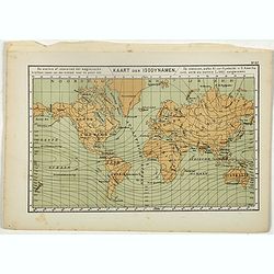
Kaart der Isodynamen.
One of the earliest thematic maps published in the Netherlands from "Atlas der natuurkundige aardrijkskunde. . .". prepared by Nicolaas Wilhelmus Posthumus. The...
- $35 / ≈ €30
Date: Amsterdam, C.L. Brinkman, 1883
A rare suite of 12 original etchings by Martin van Maele to the famous work by Edmond Haracourt.
A rare suite of 12 original etchings by Martin van Maele to the famous work by Edmond Haracourt. The series was published anonymously in a small edition. These etchings a...
Date: Nevers, Brussels, 1882,1883
Kaart der Isogonen en Isoklinen.
One of the earliest thematic maps published in the Netherlands from "Atlas der natuurkundige aardrijkskunde. . .". prepared by Nicolaas Wilhelmus Posthumus. The...
Date: Amsterdam, C.L. Brinkman, 1883
![[2 Sheets] Carte Générale de l'Océan Pacifique Dressée Par Mr. C. A. Vincendon-Dumoulin. . . Pl. 1. N° 1092. / Ocean Pacifique Feuille 2. . . Pl. 2. N° 1093.](/uploads/cache/26731-250x250.jpg)
[2 Sheets] Carte Générale de l'Océan Pacifique Dressée Par Mr. C. A. Vincendon-Dumoulin. . . Pl. 1. N° 1092. / Ocean Pacifique Feuille 2. . . Pl. 2. N° 1093.
Two sea charts depicting the Pacific Ocean, with nice detail of Hawaii. Sheet 1 shows the south east Asian region. The second North America and part of South America. Pre...
- $900 / ≈ €775
Date: Paris, 1845, updated for 1884
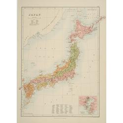
Japan.
A detailed lithographed map of Japan including Hokkaido and including a small inset of the environs of Tokyo & Yokohama. Lower part map a numbered key to divisions an...
- $200 / ≈ €172
Date: Edinburg, 1884
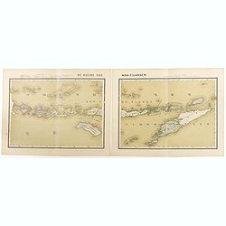
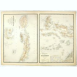
De kleine Soenda-Eilanden. Schaal van 1:800000.
Very detailed two sheet map of Soenda Islands, taken from "Atlas van Nederlandsch Oost- en West-Indie", prepared by doctor I. Dornseiffen, and published by publ...
- $30 / ≈ €26
Date: Amsterdam, Seyffardt, 1884

Driving chart of Hartford and vicinity : 15 miles around.
Road map by Albert A. Hyde & Co. of Hartford and vicinity, with the Connecticut River in the center. Published by Albert A. Hyde & Co., in New York and lithograph...
Date: New York / Philadelphia, 1884
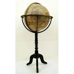
Globe terrestre d'après les découvertes..
Attractive and large (height 112cm) library globe by a prominent Paris globe maker, with a brass meridian circle, horizon ring, and hour ring, supported by four brass qua...
Date: Paris, ca. 1885
Océan Pacifique. Archipel de la Société. Iles Raiatea et Tahaa. 1ère Feuille. Ile Tahaa..
Large scale chart focused on the island Tahaa, in French Polynesia.Showing a few details of the village of Tahaa, banks, isles and soundings made in meters. Relief is sho...
- $200 / ≈ €172
Date: Paris, 1885

Wandkarte von Europa von H.Berghaus. . .
Large wall map of Europe printed in chromo-lithography. Prepared by Heinrich Berghaus and published by Justus Perthes in Gotha.Heinrich Berghaus, with support of Alexande...
Date: Gotha, Perthes, ca.1885
Kaart van Celebes / Kaart van Zuid-West-Celebes : bevattende de Gouvernem.ts, de leenroerige en een gedeelte der bondgenootschappelijke landen behoorende tot het Gouvernement van Celebes en onderh.
Very detailed map taken from "Atlas der Nederlandsche bezittingen in Oost-Indië", who was published by Departement van Koloniën".First edition of one of ...
- $50 / ≈ €43
Date: The Hague, 1883-1885
Kaart van't noordwestelijke gedeelte der Residentie Amboina . . . / Kaart der Molukken.
Two very detailed maps on one sheet, taken from "Atlas der Nederlandsche bezittingen in Oost-Indië", who was published by Departement van Koloniën".The m...
- $75 / ≈ €65
Date: The Hague, 1883-1885
![[Title page] Der Nederlandsche Bezittingen in Oost-Indië . . .](/uploads/cache/37336-250x250.jpg)
[Title page] Der Nederlandsche Bezittingen in Oost-Indië . . .
Decorative title page with, in the lower part, a schematic map of Indonesia, and two hemispheres. Taken from "Atlas der Nederlandsche bezittingen in Oost-Indië"...
- $75 / ≈ €65
Date: The Hague, 1883-1885

Kaart van Het Noordelijk Gedeelte Van Het Eiland Borneo.
A very detailed map of Northern Borneo including Brunei, taken from the "Atlas der Nederlandsche bezittingen in Oost-Indië", which was published by Departement...
Date: The Hague, 1883-1885
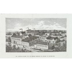
De luciferfabriek van de Heeren Mennen en Krunen te Eindhoven.
Wood engraving published in "Katholieke Illustratie", showing the match factories of Mennnen en Krunen in Eindhoven. Founded in 1870 by banker Christiaan Mennen...
- $40 / ≈ €34
Date: s-Hertogenbosch, H.Bogaerts, ca. 1885
Atlas des Missions Catholiques.
Vingt cartes teintées, avec texte explicatif par R. P. O. Werner de la Compagnie de Jésus. Traduit de l’Allemand, revu et augmenté par M. Valérien Groffier, auteur ...
- $1000 / ≈ €861
Date: Lyon, 1886
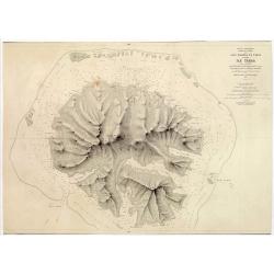
ILE UVEA CROQUIS DES BAIES DE MUA ET DE MATA UTU.
Mata-Utu is the capital of Wallis and Futuna, an overseas collectivity of France. It is located on the island of Uvéa, in the district of Hahake, of which it is also the...
- $80 / ≈ €69
Date: Paris, 1887
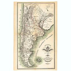
Carte générale de la République Argentine dressée d'après les données les plus récentes.
An UpToDate map of the Argentinian Republic published in Basel by "le Bureau Officiel d'Information de la République Argentine". Detailed map of Argentina show...
- $350 / ≈ €301
Date: Basel, 1887
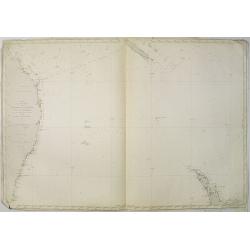
Carte de la Mer comprise entre l'Australie, la Nelle. Zélande et la Nelle.
Sea chart of the Pacific Ocean between Australia, New Zealand and New Caledonia. Including the towns of Sydney, Brisbane. The northern tip of New Zealand in lower right c...
- $350 / ≈ €301
Date: Paris, 1872 updated for 1888
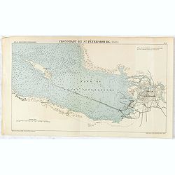
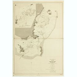
Cronstadt et St. Petersbourg.
Detailed plan of the port and city of St. Petersburg including Kotlin Island and the fortified town of Kronstadt.
- $35 / ≈ €30
Date: Paris, 1888
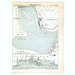
Tjilatjap (1888)
Detailed plan of the port and city of Tjilatjap on Java. Taken from "Atlas des Ports Etrangers". Lithographed by A. Simon.
Date: Paris, 1888
(Complete map of ancient and modern geography of China)
The second earliest edition of China’s first commercial map, Gujin di yu quan tu 《古今地輿全圖》(Complete map of ancient and modern geography of China) made du...
Date: Jingdu dashuntang, 1888
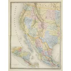
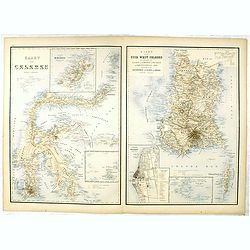
Etats Unis (Etats de l' Ouest).
Large format highly detailed map of the states and territories of the West, with Central America, included in a large inset titled "Etats de l'Amerique Centrale"...
Date: Paris, 1889