Browse Listings
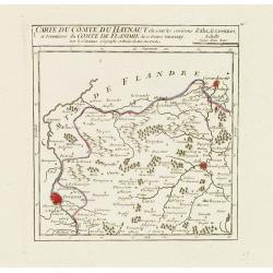
I. Carte du Comté du Haynaut.. Tournay.
Attractive small map encompassing part of Hainaut, between Tournai and Ath. From Atlas Portatif Universel, by Robert de Vaugondy.Edited by : "Au dépôt de Géograph...
Date: Paris, 1799
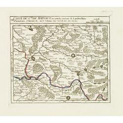
VIII. Carte du C.té de Haynaut où sont les environs de Landrechies..
Attractive small map showing an area straddling the regions Picardy and Nord. It shows the towns of La Capelle, Landrecies and Avesnes-sur-Helpe.From Atlas Portatif Unive...
Date: Paris, 1799
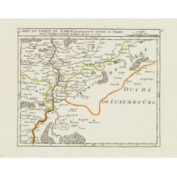
X. Carte du Comté de Namur où se trouvent les environs de Dinant.
Attractive small map showing an area straddling the border between France and Belgium.It shows Dinant, Ciney, and the fort of Charlemont, built by Charles V on the French...
Date: Paris, 1799
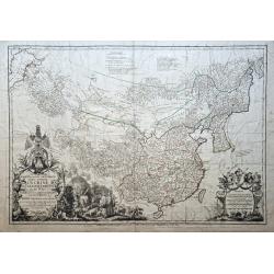
Carte la plus generale et qui comprend la Chine, la Tartarie chinoise et le Thibet. . .
With a quite elaborately pictorial cartouche, engraved by G.Kondet. Very detailed map of China, Tibet and Korea. Jean Baptiste Bourguignon d' Anville (1697-1782), French ...
- $2700 / ≈ €2287
Date: Paris, Dezauche, 1789–1799
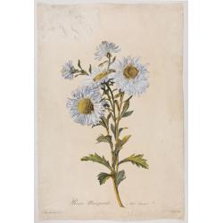
Reine-Marguerite. Aster chinensis. L.
A bouquet of flowers. Engraved by P.F. Le Grand after designs by the Dutch-born Gerard van Spaendonck (1746-1822).Taken from the rare work "Fleurs dessinées d'aprè...
Date: Paris, ca. 1800
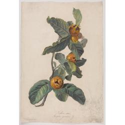
Neflier cultivé. Mespilus germanica. L.
A bouquet of flowers. Engraved by P.F. Le Grand after designs by the Dutch born Gerard van Spaendonck (1746-1822).Taken from the rare work "http://www.swaen.com/Fleu...
Date: Paris, ca.1800
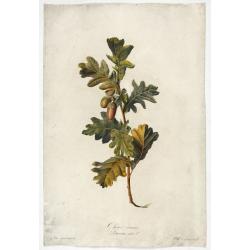
Chêne commun.
Engraved by P.F. Le Grand after designs by the Dutch born Gerard van Spaendonck (1746-1822).Taken from the rare work "Fleurs dessinées d'après nature. . . receuil ...
Date: Paris, c. 1800

Seringat odorant. Philadelphus coronarius. L.
Bouquet of Seringats. A bouquet of flowers. Engraved by P.F. Le Grand after designs by the Dutch born Gerard van Spaendonck (1746-1822).Taken from the rare work "Fle...
Date: Paris, c. 1800
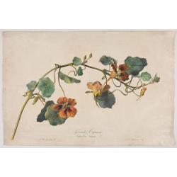
Grande Capucine Tropoeolum majus. L.
The true Nasturtium, stipple engraving by P.F. Le Grand after designs by the Dutch-born Gerard van Spaendonck (1746-1822).Taken from the rare work "Fleurs dessinées...
Date: Paris, c.1800

Vue du sperbe Temple de St.Sophie .. a Constantinople.
A fanciful depiction of the Aya Sofya in Istanbul. In the eighteenth and nineteenth centuries there were many popular speciality establishments in Paris, Augsburg and Lon...
Date: Paris, 1800

No title: training a horse.
After a design by Silva.
- $75 / ≈ €64
Date: Italy, c. 1800

Carte des côtes du Golfe du Mexique compris entre la pointe sud de la presqu'Ile de la Floride et la pointe nord de la presqu'Ile d'Yucatan:...
Detailed and important early chart of the Gulf Coast and Florida and dated 1800. First French edition of "the first printed [map] to show and name Galveston Bay&qu...
Date: Paris, 1800

Reis-kaart van het Britsche gezantschap van Hang-choe-foe naar Quang-choe-foe of Kanton in China.
Uncommon map of eastern part of China, showing a journey of the English Embassy from Hangzhou (south of Shanghai) to Guangzhou (Canton). The maps is giving a wealth of in...
Date: Netherlands, c.1800

Botanibay, Englischer Verweisungs Ort fur Verbrecher. / Laijene Franzosicher Verweisungs Ort fur Verbrecher.
Copper engraving with four scenes and one portrait of Frederick III of Saxony on one sheet. In the upper part fanciful views of Botany Bay with English and French settlem...
Date: Zittau, 1798-1800

Erfolgte Kapitulation zwischen dem General Bonaparte und den Gross Leister von Malta. Vor der Hauptstadt Walette zu Maltha, am 10 Juni 1798.
Copper engraving with three scenes and one portrait on one sheet. In upper a view of Bonaparte arriving at Valletta. Published in "Allgemeine Welt-Chronik oder neue ...
Date: Zittau, 1798-1800
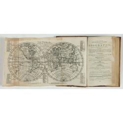
A new and easy introduction to universal geography: In a series of letters to a youth at school. . . The ninth edition, improved and considerably enlarged.
This is the interesting ninth edition, with 26 full-page maps as called for in "Directions to the binder". The ninth edition was improved and considerably enlar...
Date: London, 1800
![[ Manuscript map of the Ligurian coast from Pietra to Genova ].](/uploads/cache/26627-250x250.jpg)
[ Manuscript map of the Ligurian coast from Pietra to Genova ].
Very detailed French manuscript map of the Ligurian coast from Pietra and Finale, Savone to Genoa with the Maritime Alps in the background. The Liguria coast borders to n...
Date: France, ca. 1790-1800
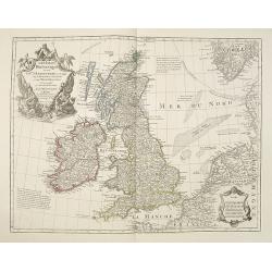
Les Isles Britanniques ou sont le Rme. D'Angleterre . . . Par G. De L'Isle. . . A Paris Chez Dezauche. . .
Uncommon late edition, (dated An 8, 1800 ) of this map of the British Isles prepared by DeL'Isle and published during the French Revolution by Dezauche / Buache. The bott...
Date: Paris, 1800
Dutch landscape.
Finely executed water color in pen and ink and gray wash color. Showing a Dutch landscape with farm house and windmills on the horizon.
- $60 / ≈ €51
Date: Probably The Netherlands, ca. 1800
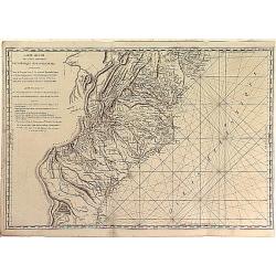
Carte Réduite des Côtes Orientales Del'Amérique Septentrionale Contenant partie du Nouveau Jersey, la Pen-sylvanie, le Mary-land, la Virginie, la Caroline Septentrionale, la Caroline Méridionale et la Georgie. . .
Scarce Rome edition of an French map made expressly for use of the French Navy during the American Revolution. Covering the area of Maryland, North and South Virginia. Ph...
- $900 / ≈ €762
Date: Genova, Yves Gravier, c.1800
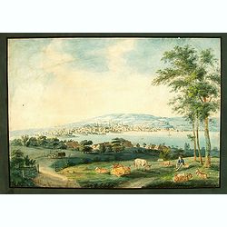
Vue de Zurich.
Good sized panoramic view of Zürich in the style of BLEULER with the foreground a resting shepherd with his sheep's under a tree. The engraving/etching is hand colored a...
- $900 / ≈ €762
Date: Ca. 1800
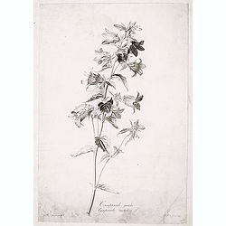
Campanule gantelée. - Campanule trachaelium L.
Bouquet of poppy flowers, engraved by P.F. Le Grand after designs by the Dutch born Gerard van Spaendonck (1746-1822).Taken from the rare work "Fleurs dessinées d'a...
Date: Paris, c.1800

Lion and Bull made of terracotta.
Very fine terracotta figure of a lion symbolizing the continent of Africa. The Bull symbolizing Europe.The items will be dispatched in 4 wooden crates from Belgium. Pleas...
Date: Netherlandisch , 1780~1800
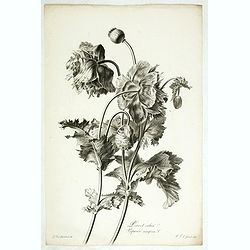
Pavot cultivé. Papaver somniferum L.
Bouquet of poppy flowers, stipple engraving by P.F. Le Grand after designs by the Dutch born Gerard van Spaendonck (1746-1822).Taken from the rare work "Fleurs dessi...
Date: Paris, c.1800
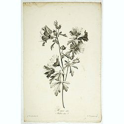
Mauve alcée. Malva alcea L.
Greater musk-mallow, stipple engraving by P.F. Le Grand after designs by the Dutch born Gerard van Spaendonck (1746-1822).Taken from the rare work "Fleurs dessinées...
Date: Paris, c.1800

Seringat odorant - Philadelphus coronarius L.
Sweet Mock-Orange, English Dogwood engraving by P.F. Le Grand after designs by the Dutch born Gerard van Spaendonck (1746-1822).Taken from the rare work "Fleurs dess...
Date: Paris, c.1800

Rose de Provins. Rosa Gallica.
Bouquet of roses, stipple engraving by J.Godefroy after designs by the Dutch born Gerard van Spaendonck (1746-1822).Taken from the rare work "Fleurs dessinées d'apr...
Date: Paris, c.1800
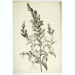
Mufle de veau. Antirrhinum majus L.
Bouquet of Common Snapdragons, engraving by P.F. Le Grand after designs by the Dutch born Gerard van Spaendonck (1746-1822).Taken from the rare work "Fleurs dessiné...
Date: Paris, c.1800

Souci des Jardins. Calendula Officinalis. L.
The Common Marigold, engraving by P.F. Le Grand after designs by the Dutch born Gerard van Spaendonck (1746-1822).Taken from the rare work "Fleurs dessinées d'aprè...
Date: Paris, c.1800

Iris bleu - clair. Iris pallida.
Dalmatian Iris or Sweet Iris, engraving by P.F. Le Grand after designs by the Dutch born Gerard van Spaendonck (1746-1822).Taken from the rare work "Fleurs dessinée...
Date: Paris, c.1800

Digitale pourprée. Digitalis purpurea L.
The foxglove, engraving by P.F. Le Grand after designs by the Dutch born Gerard van Spaendonck (1746-1822).Taken from the rare work "Fleurs dessinées d'après natur...
Date: Paris, c.1800
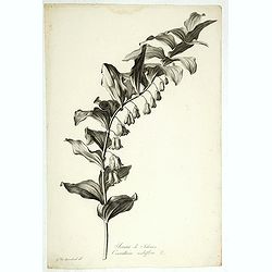
Sceau de Salomon. Convallaria multiflora L.
King Solomon's Seal or David's Harp, engraving by P.F. Le Grand after designs by the Dutch born Gerard van Spaendonck (1746-1822).Taken from the rare work "Fleurs de...
Date: Paris, c.1800

Grande Capucine. Tropaeolum majus. L.
Indian cress or monks cress, engraving by P.F. Le Grand after designs by the Dutch born Gerard van Spaendonck (1746-1822).Taken from the rare work "Fleurs dessinées...
Date: Paris, c.1800

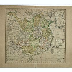
La China e Giapone.
Uncommon map of China, Korea, Japan and Taiwan (I.Formosa), only one town labeled, Tayoan. Very strange shape for Japan.The map is of interest for the use of Mar di Corea...
Date: Italy, ca. 1800
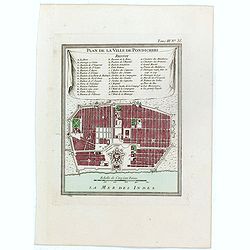
Plan de la ville de Pondicheri.
The first detailed French plan of Pondicherry. In the lower part, a lettered and numbered key and the coat of arms of Mr. Joseph-François Dupleix.The Compagnie des Indes...
- $120 / ≈ €102
Date: Paris, 1800
![Die Obere oder Nordliche Halbkugel der Erde auf den Horizont von Wien, Sterographisch Entworfen ... [together with] Die Untere oder Sudliche Halbkugel der Erde auf den Horizont von Wien, Stereographisch ...](/uploads/cache/39377-250x250.jpg)
Die Obere oder Nordliche Halbkugel der Erde auf den Horizont von Wien, Sterographisch Entworfen ... [together with] Die Untere oder Sudliche Halbkugel der Erde auf den Horizont von Wien, Stereographisch ...
A set of two uncommon large format maps of the Northern and Southern Hemisphere, based upon the work of Johann Anton Ecker (1755-1820). First published in 1794, this is t...
- $2000 / ≈ €1694
Date: Vienna, Phil. Jos Schalbacher, 1800
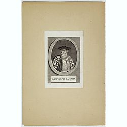
Dom Vasco Da Gama.
Portrait of Dom Vasco da Gama (c.1460 - 1524) , was a Portuguese explorer. He became famous for being the first European explorer to leave Europe by ship and sail to Indi...
- $80 / ≈ €68
Date: c. 1800
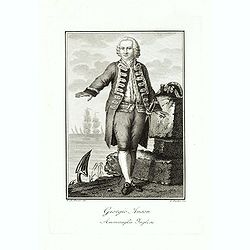
Giorgio Anson Ammiraglio Inglese.
Copper engraved portrait of George Anson, 1st Baron Anson PC, FRS, RN (23 April 1697 – 6 June 1762), engraved by L. Rados after G.B.Bosio.Anson was a British admiral an...
- $300 / ≈ €254
Date: Ca. 1800

Deutschlands Postkarte begraenzt von Oesterreich, Preussen, Frankreich, Holland, Italien und der Schweiz. . .
A detailed and crucial post-road map prepared by Ignaz Heymann. The map shows the Low Countries, Germany, Poland, Austria, Hungary, etc.Borders in original outline colo...
Date: Triest, 1800

Recueil de cartes géographiques pour la description de l'Indostan . . .
First French edition, the maps revised by Jean Nicholas Buache. The English original edition was published in London in 1783 by Brown under the title "Memoir of a ...
Date: Paris, Poignée, an VIII = 1800

(Interior scene)
Lively interior scene with the men sitting together and drinking around a table whilst the women look after the children, weave hay and the older children cooking. Engrav...
- $100 / ≈ €85
Date: Paris, ca. 1800

Theodorus Primus Corsicae Rex.
Portrait of Everard Jabach, three-quarter length, standing by the fragment of a column, facing left, wearing a cloak and doublet with plain collar, his left arm held behi...
Date: Paris, 1652 - 1800
![[Title page] AtlasGeneral Méthodique et Elémentaire . . .](/uploads/cache/48054-250x250.jpg)
[Title page] AtlasGeneral Méthodique et Elémentaire . . .
Title page from Atlas general Méthodique et Elémentaire. Very fine, typical French title page, published with Desnos.
Date: Paris, 1800
![[Portrait of Nicolas Louis de La Caille].](/uploads/cache/47704-250x250.jpg)
[Portrait of Nicolas Louis de La Caille].
Portrait of Nicolas Louis de La Caille, also known as L'Abbé De La Caille, engraved by Thérèse Devaux.
- $75 / ≈ €64
Date: Paris, ca. 1800

Early 19th century magnetic dry card compass with wooden bowl,
Brass dry rose marine compass, in its mahogany case. The mariner's compass, which enabled mariners to know the direction in which they were sailing, has always been one o...
Date: ca. 1800
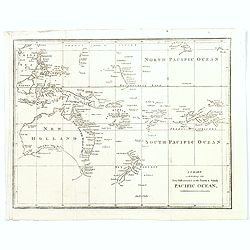
A Chart exhibiting the New Discoveries in the North & south Pacific Ocean.
A scarce map, probably from an English travel journal, produced in the late eighteenth century, showing the latest cartographic discoveries within the Pacific region. Map...
Date: London, ca. 1800

Le Go-Ruck.
An attractive representation of a bird by François Levaillant publisher in Paris 1801 in Histoire naturelle d'une partie d'oiseaux nouveaux et rares de l'Amérique et de...
Date: Paris 1801

Le S. a Cinture Marron.
An attractive representation of a bird by François Levaillant publisher in Paris 1801 in Histoire naturelle d'une partie d'oiseaux nouveaux et rares de l'Amérique et de...
Date: Paris 1801

Shinkan Nagasaki no Dzu.
The oldest of these so-called Nagasaki pictures (Nagasaki-zu) were two panoramic prints by the artist Chikujuken that served as guides to the city of Nagasaki for visitor...
Date: Nagasaki, 1801

La Méesange Brune Male. La Méesange Grise. . .
Very decorative plate from Histoire naturelle des oiseaux d'Afrique, published by Delachaussée. Levaillant's interest in natural history led him to explore Africa as the...
- $150 / ≈ €127
Date: Paris, 1801

L'Acoli.
Very decorative plate from Histoire naturelle des oiseaux d'Afrique, published by Delachaussée. Levaillant's interest in natural history led him to explore Africa as the...
- $230 / ≈ €195
Date: Paris, 1801
Plan de la ville de Rome, d'après celui publié par J.B. Nolli . . .
Beautiful town-plan of Rome, drawn up after the famous plan of Rome, executed by Giambattista Nolli in 1748. Decorated with a beautiful title cartouche topped by the coat...
- $1000 / ≈ €847
Date: Paris, Jean, 1801
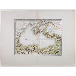
Carte de la Mer Noire ou Kara Degniz.
Original antique copper engraved map of the Black Sea with attractive original hand coloring.
- $200 / ≈ €169
Date: Paris, 1791-1801
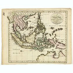
A new and Accurate map of the islands and Channels between China and New Holland.
Highly detailed map of Southeast Asia, covering the region between Formosa and Hainan islands in the North and Australia in the South.Including Burma to Taiwan with parts...
- $600 / ≈ €508
Date: Edinburgh, 1801

Kaart Van Nieuw Zeeland in de Jaaren 1769 en 1770 bezogt door den Luitenant J. Cook met het Schip De Endeavour.
A uncommon issue of this key map of New Zealand from the Dutch edition of Cook's map of New Zealand, published in 'Reize rondom de Waereld door James Cook', a Dutch editi...
Date: Leyden, Amsterdam & The Hague: Honcoop, Allart & van Cleef, 1795-1801
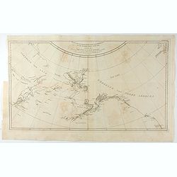
Kaart van de Noord-West kust van Amerika en de Noord-Oost kust van Asia. . .
A uncommon issue of this important map of the Northern Pacific and contiguous coasts of America and Asia, published in 'Reize rondom de Waereld door James Cook', a Dutch ...
- $1000 / ≈ €847
Date: Leyden, Amsterdam & The Hague: Honcoop, Allart & van Cleef, 1795-1801

Carte de la partie septentrionale des Etats Unis..
An attractive 1801 map of North America's east coast north of Long Island. Including St.Laurence River as far south as Lake Ontario. Engraved by André and P.F.Tardieu. A...
Date: Paris, 1801
![Schat-Kamer ofte konst der stuurlieden, inhoudende Een duidelyke onderwyzinge in de navigatie. . . [bound with] Geographische Tadfel vande Graaden.. Voornaamste Zee-haavens. . .](/uploads/cache/33114-250x250.jpg)
Schat-Kamer ofte konst der stuurlieden, inhoudende Een duidelyke onderwyzinge in de navigatie. . . [bound with] Geographische Tadfel vande Graaden.. Voornaamste Zee-haavens. . .
Rare and important manual originally prepared by Klaas de Vries and improved by Evert Floryn and S.Hollander of the "Schat-Kamer ofte konst der stuurlieden" (Tr...
Date: Amsterdam, Wed. Gerard Hulst van Keulen, 1802

L'Heoro-taire brun. Pl.65.
A very rare print of a humming bird from Histoire naturelle et générale des colibris, oiseaux-mouches, jacamars et promerops, by Jean Baptiste Audebert. Before his deat...
- $230 / ≈ €195
Date: Paris, 1800-1802

Le G. G. Noir et Bleu.
A very rare print of a humming bird from Histoire naturelle et générale des colibris, oiseaux-mouches, jacamars et promerops, by Jean Baptiste Audebert. Before his deat...
- $230 / ≈ €195
Date: Paris, 1800-1802

Le Neghôbàrra. Pl.64
A very rare print of a bird from Histoire naturelle et générale des colibris, oiseaux-mouches, jacamars et promerops , by Jean Baptiste Audebert. Before his death Audeb...
- $230 / ≈ €195
Date: Paris, 1800-1802
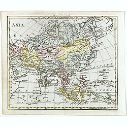
Asia.
The map is of interest for the use of Gulf of Corea, the sea between Korea and Japan.William Darton, Sr. started his mapmaking business in 1787 in London, and thus began ...
- $300 / ≈ €254
Date: London, 1802
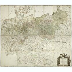
General Karte von den saemtlichen Kšnig. Preussischen Staaten welche zugleich als POSTKARTE durch die Länder der Preussischen Monarchie und durch ganz Deutschland diendt. . .
Large wall map (1,25 x 1,38 meters) of Prussia and present-day Poland, prepared by D.F. Sotzmann and published by Königl. Preuss. Academie Kunst und Buchhandlung.A detai...
- $1500 / ≈ €1271
Date: Berlin, 1802
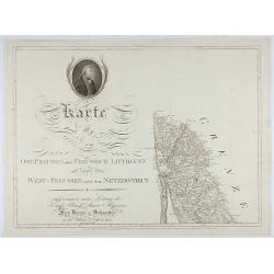
Karte von Ost-Preussen nebst Preussisch Litthauen und West-P
The title section of this important multi-sheet map of Prussia, Lithuania and Poland, showing territories of present Lithuania. With a medallion representing the King of ...
Date: Berlin, 1802
![[Title page] Atlas de la République Française. . .](/uploads/cache/47741-250x250.jpg)
[Title page] Atlas de la République Française. . .
Title page of Atlas de la République Française by Pierre Gilles Chanlaire in 1802.
- $150 / ≈ €127
Date: Paris, 1802

United States of North America. Carte des Etats-Unis de l'Amerique Septentrionale / copiée et gravée sur celle d'Arrowsmith, corrigée et considérablement augmentée... par P. F. Tardieu...
FIRST EDITION. An impressive wall map here in 4 unjoined sheets and large margins. RARE in these untouched, full sheets. Recorded examples are usually offered as folding ...
Date: Paris: An XI - 1802
![[Lot of 5 maps] Kaart van de noord-west kust van Amerika en de noord-oost kust van Asia.](/uploads/cache/19136-250x250.jpg)
[Lot of 5 maps] Kaart van de noord-west kust van Amerika en de noord-oost kust van Asia.
- Kaart van de noord-west kust van Amerika en de noord-oost kust van Asia. Opgenoomen in de Jaaren 1778 en 1779. Captain James Cook (1728-79), explorer, circumnavigato...
Date: Leiden, 1795-1803

Teatro della guerra nelle Flandre Austriache e Francesi. . .
Rare folio-sized map of Belgium by Antonio Zatta e Figli, from a never-finished atlas by the ‘Società Calcografia’, a partnership of the two main Venetian publishers...
Date: Venise, 1803
![[2 maps] Des europäischen Russlands nördlicher Theil. / Des europäischen Russlands sûdlicher Theil.](/uploads/cache/34707-250x250.jpg)
[2 maps] Des europäischen Russlands nördlicher Theil. / Des europäischen Russlands sûdlicher Theil.
Detailed map of Russia in two sheets, published by Johannes Wach of Augsburg.
- $250 / ≈ €212
Date: Augsburg, 1803
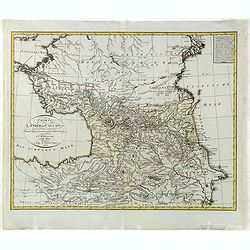
Charte der Laender am Caucasus nach dem besten vorhanden Charten, Reisen, und astronomischen Ortbestimungen gezeichnet von I.C.Reinecke .
Scarce map of the Ukraine and Caucasus filled with great topographical detail, as well as numerous place names. According to the title the map has been drawn by Johann Ma...
- $750 / ≈ €635
Date: Weimar, 1803
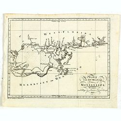
Charte von der mündung des Mississippi. Weimar, Verlage des Landes Indust. Compt. 1803.
Scarce map showing the mouth of the Mississippi into the Gulf of Mexico. With Pensacola in Western Florida, Mobile Bay in Alabama and Louisiana with New Orleans and their...
- $300 / ≈ €254
Date: Weimar, 1803

Jean Denys Barbieé du Bocage Geograph des Franz. Ministeriums der auswärtigen Angelegenheiten.
Stipple engraved portrait of Jean Denis Barbie du Bocage (1760 - 1825), probably engraved by Conrad Westermayr.Jean Denys Barbieé was a French cartographer active in Par...
- $300 / ≈ €254
Date: Hanau, ca. 1803
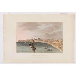
Déde, near Tripoli.
Showing a few boats and harbour in Déde near Tripoli in Libanon, sketched on the spot by F.B. Spilsbury and drawn by D. Orme for "Picturesque Scenery in the Holy La...
- $75 / ≈ €64
Date: London, 1803
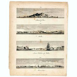
Island of Elba / Malta / Inner harbour of Malta / Alexandria.
Four views on a sheet, engraved by S.I Neele. Profile views of the island of Elba, Alexandria and two profile views of Malta and the Inner Harbour in Valletta.
Date: London, 1803
Carte générale des marches, positions, combats et batailles de l'Armée de réserve. . . (N°12)
Very detailed map centered on the Italian Alps showing the marches, positions, combats and battles of the famous Napoleon's crossing the Alps in the year 8 (1799) . In an...
- $750 / ≈ €635
Date: Paris, 1803
Carte de l'Europe dediée a Son Altesse royale Monseigneur Charles Louis archiduc d'Autriche, prince royal de Hongrie et de Bohéme, chevalier de la Toison d'Or, Grand-Croix de l'ordre...
Probably the largest published map of Europe during the regime of Napoleon.In upper left corner a large title cartouche with coats of arms and a dedication to Archduke Ch...
- $4000 / ≈ €3388
Date: Paris, 1803
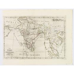
Le Indie Orientali.
A nice map of the East Indies, published in Rome at the beginning of the nineteenth century. Shows from the Persian Gulf across Pakistan, India, and Bangladesh, then sout...
Date: Rome, ca 1803
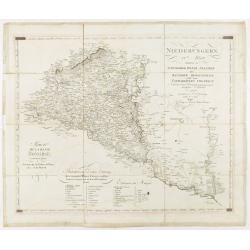
Niederungern Ivtes Blatt enthaltend die Schumegher, Tolner, Baranyer. . . Partie IVè de la basse hongrie contenant les comtes de Schumegh, de Tolna, de Baranya. . .
Map of Hungary. In the lower explicative key. Detailed map of the Southern part of Hungary with Kopreinitz until Lake Balaton, which is one of the most popular summer des...
Date: Kunst u. Industrie Compt., Vienna, 1803
Charte von China nach Murdochischer Projection entworfen. ... Berichtiget, und gezeichnet von H.F.A. Stieler. . .
Uncommon map of China prepared by H.F.A.Stieler, with parts of Taiwan, Tibet, Mongolia and the Korean peninsula, with a great many place names, a key to (and brief explan...
- $600 / ≈ €508
Date: Weimar, 1804
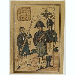
First Russian mission.
A rare Nagasaki-e print of the first Russian mission to Japan.
- $2250 / ≈ €1906
Date: Nagasaki, c.1804