Browse Listings
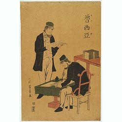
Two traders.
A rare Nagasaki-e print of the first Russian mission to Japan.
- $2250 / ≈ €1906
Date: Nagasaki, c.1804
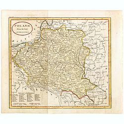
Poland from the best authorities.
Detailed map of Poland from "A New Geographical, Historical, and Commercial Grammar", by William Guthrie. William Guthrie (later engraver for Carey) London, UK....
Date: London, 1805
Die Götha-Elf. Nach Friedr. Akrel's Plancharta öfver Trollhättan reducirt.
Uncommon map prepared by Carl Frederik Akrell. Showing the River Gotha from Gothenburg till Vänersborg.Published by Geographisen Institut in Weimar. A scale in Swedish m...
- $100 / ≈ €85
Date: Weimar, 1805
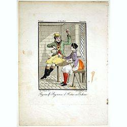
Paysan & Paysanne d'Hanas en Boheme.
Originally hand-colored mezzotint from 'Costumes civils actuels de tous les peuples connus'. Engraved by Lachaussée Jeune after Jacques Grasset de Saint-Sauveur.As an et...
- $50 / ≈ €42
Date: Paris,1805
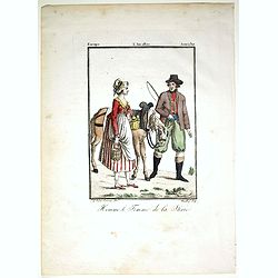
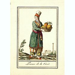
Homme & et Femme de la Sirie.
Originally hand-colored mezzotint from 'Costumes civils actuels de tous les peuples connus'. Engraved by Félix Mixelle after Jacques Grasset de Saint-Sauveur.As an etche...
- $50 / ≈ €42
Date: Paris,1805
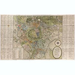
Plan de la ville de Vienne et de ses faubourgs divisés en quartiers.
Fine plan of Vienna, engraved by Franz T. Müller and published by Jean Crappi. On both side an extensive key and a color key to the different sectors in town.
- $900 / ≈ €762
Date: Vienna, 1805
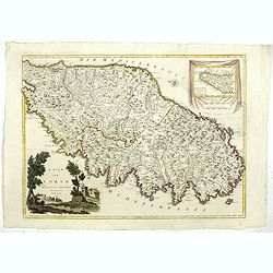
L'Isle de CORSE Divisée en ses departemens.
Nice map of Corsica, with a decorative cartouche in the left low corner. Small inset map of Sicily in the upper right corner: "Pointe de Capo Corso".This is the...
- $1750 / ≈ €1482
Date: Venise,1805
![[Title page Atlas Universel...]](/uploads/cache/47727-250x250.jpg)
[Title page Atlas Universel...]
Beautiful title-frontispiece from the famous universal atlas initiated by geographers Gilles Robert and his son Didier Robert de Vaugondy, revised, corrected and enhanced...
Date: Paris, 1805

Géographie des Plantes Equinoxiales - Tableau physique des Andes et pays voisins. . .
Physical Portrait of the Andes and adjacent lands", organized around the Chimborazo and Cotopaxi volcanoes in Ecuador.With local vegetation is illustrated pictoriall...
Date: Paris, 1805
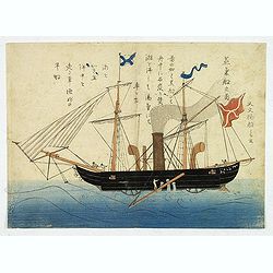
'Jokisen no zu' (Steamboat)
Nagasaki-e original Japanese woodblock print of a Steamboat. The figurehead is a striking detail.Nagasaki-e are Japanese woodblock prints that depict foreigners (Mostly ...
- $3750 / ≈ €3176
Date: Nagasaki, c.1805
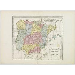
L'Espagne et le Portugal. Divisés Par Gdes. Provinces.
Map of Spain and Portugal, including the Balearic Islands archipelago. From Atlas de la Géographie de toutes les parties du monde .. Ouvrage destiné pour l'education, e...
- $80 / ≈ €68
Date: Paris, Prudhomme, Levrault, Debray, 1806
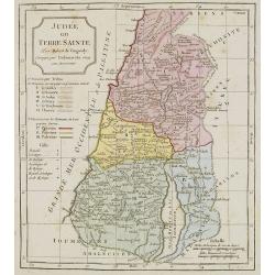
Judée ou Terre Sainte sous les Turcs.
Map of the Holy Land. By C. F. Delamarche, successor of Robert de Vaugondy, Geographer.
- $50 / ≈ €42
Date: Paris, ca.1806
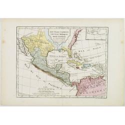
Nouvelle Espagne, Nouveau Méxique, Isles Antilles, par Robert de Vaugondy corrigés par le Cen. Lamarche Géog. Successeur de Vaugondy. l''An 3e.
Although dated 1794/95 [l'An 3e.], the map is a copy of an earlier map which appeared in Robert de Vaugondy's 1778 atlas. Hence, it does not show the newly independent Un...
- $300 / ≈ €254
Date: Paris, 1794 - 1806
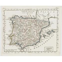
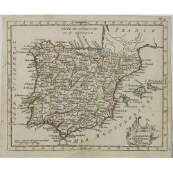
Royaumes d'Espagne et du Portugal.
Map of Spain and Portugal. By C. F. Delamarche, successor of Robert de Vaugondy, Geographer.
- $80 / ≈ €68
Date: Paris, 1794 - 1806
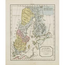
La Suède.
Map of Sweden and Finland. By C. F. Delamarche, successor of Robert de Vaugondy, Geographer.
Date: Paris, ca.1806
![[Butterflies]](/uploads/cache/25584-250x250.jpg)
[Butterflies]
Plate CXXIV from Carl Gustav Jablonsky and J.F.W. Herbst: "Natursystem aller bekannten in- und ausländischen Insecten", engraved by Bodenehr. Carl Gustav Jablo...
- $100 / ≈ €85
Date: Berlin, J. Pauli, 1785-1806
![[Butterflies]](/uploads/cache/25585-250x250.jpg)
[Butterflies]
Plate CLXXXIII from Carl Gustav Jablonsky and J.F.W. Herbst: "Natursystem aller bekannten in- und ausländischen Insecten", engraved by Bodenehr. Carl Gustav Ja...
- $100 / ≈ €85
Date: Berlin, J. Pauli, 1785-1806
![[Butterflies]](/uploads/cache/25586-250x250.jpg)
[Butterflies]
Plate CXCVIII from Carl Gustav Jablonsky and J.F.W. Herbst: "Natursystem aller bekannten in- und ausländischen Insecten", engraved by Bodenehr. Carl Gustav Jab...
- $100 / ≈ €85
Date: Berlin, J. Pauli, 1785-1806
![[Butterflies]](/uploads/cache/25587-250x250.jpg)
[Butterflies]
Plate CXXIV from Carl Gustav Jablonsky and J.F.W. Herbst: "Natursystem aller bekannten in- und ausländischen Insecten", engraved by Bodenehr. Carl Gustav Jablo...
Date: Berlin, J. Pauli, 1785-1806
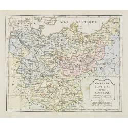
Cercle de Haute Saxe et de Basse Saxe. . .
Map of the duchies of Saxony (upper & lower). By C. F. Delamarche, successor of Robert de Vaugondy, Geographer.
- $50 / ≈ €42
Date: Paris, 1794 - 1806
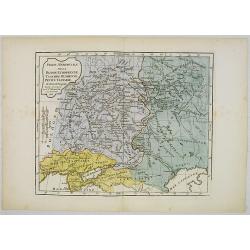
Partie Méridionale de la Russie Européenne, Tartarie, Russienne, Petite Tartarie.
Map of the southern part of Russia and Tartary. By C. F. Delamarche, successor of Robert de Vaugondy, Geographer.
- $90 / ≈ €76
Date: Paris, 1806
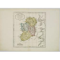
L' Irlande.
Map of Ireland. By C. F. Delamarche, successor of Robert de Vaugondy, Geographer.
- $90 / ≈ €76
Date: Paris, 1794 - 1806
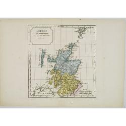
L' Ecosse.
Map of Scotland. By C. F. Delamarche, successor of Robert de Vaugondy, Geographer.
- $50 / ≈ €42
Date: Paris, 1794 - 1806
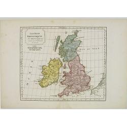
Les Isles Britanniques.
Map of British Isles. By C. F. Delamarche, successor of Robert de Vaugondy, Geographer.
- $80 / ≈ €68
Date: Paris, 1794 - 1806

Paraguay, Chili, Terre Magellan ?
Map of Paraguay, Chili, and Argentina . By C. F. Delamarche, successor of Robert de Vaugondy, Geographer.
Date: Paris, 1794 -1806
![Morokoshi Meisho Zue [Illustrated Description of Famous Sites of China].](/uploads/cache/34118X-250x250.jpg)
Morokoshi Meisho Zue [Illustrated Description of Famous Sites of China].
Published in Osaka, Kawachiya Genhichiro, et al. [8 book sellers], slightly later issue but apparently in Edo period, using all the same woodblocks of original first edit...
Date: Osaka, Edo, slightly later than Bunka 3, year of the tiger - 1806
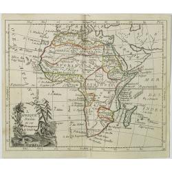
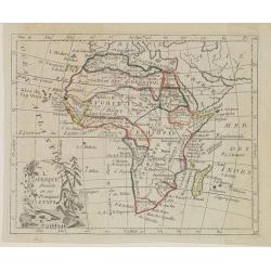
L'Afrique . . .
Map of the African continent, from Atlas moderne portatif composé de vingt-huit cartes sur toutes les parties du globe terrestre .. A l'usage des Colléges, des Pensions...
Date: Paris, Prudhomme, Levrault, Debray, 1806
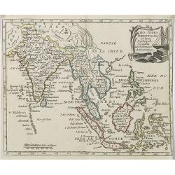
Les Indes Orientales et leur Archipel . . .
Map of India, the Maldive Islands, the Indonesian and Philippine Islands, from Atlas moderne portatif composé de vingt-huit cartes sur toutes les parties du globe terres...
- $300 / ≈ €254
Date: Paris, Prudhomme, Levrault, Debray, 1806
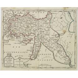
Turquie d'Asie . . .
Map of Turkey, including Cyprus, Palestine, etc. , from Atlas moderne portatif composé de vingt-huit cartes sur toutes les parties du globe terrestre .. A l'usage des Co...
- $100 / ≈ €85
Date: Paris, Prudhomme, Levrault, Debray, 1806
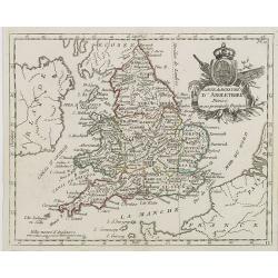
Carte du Royaume d' Angleterre . . .
Map of England and its counties, from Atlas moderne portatif composé de vingt-huit cartes sur toutes les parties du globe terrestre .. A l'usage des Colléges, des Pensi...
Date: Paris, Prudhomme, Levrault, Debray, 1806
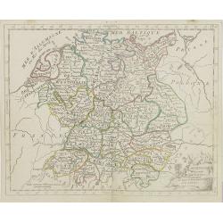
L'Allemagne . . .
Map of Germany, from Atlas moderne portatif composé de vingt-huit cartes sur toutes les parties du globe terrestre .. A l'usage des Colléges, des Pensions & des Mai...
- $50 / ≈ €42
Date: Paris, Prudhomme, Levrault, Debray, 1806
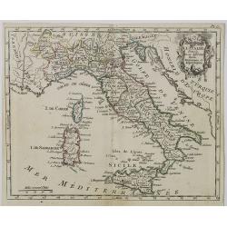
Carte d' Italie . . .
Map of Italy from Atlas moderne portatif composé de vingt-huit cartes sur toutes les parties du globe terrestre .. A l'usage des Colléges, des Pensions & des Maison...
Date: Paris, Prudhomme, Levrault, Debray, 1806
L' Espagne et le Portugal . . .
Map of Spain and Portugal, from Atlas moderne portatif composé de vingt-huit cartes sur toutes les parties du globe terrestre .. A l'usage des Colléges, des Pensions &a...
Date: Paris, Prudhomme, Levrault, Debray, 1806
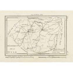
Département de la Dyle.
Map centered on Bruxelles with a short key list in the lower right corner. From Atlas de la Géographie de toutes les parties du monde .. Ouvrage destiné pour l'educatio...
- $40 / ≈ €34
Date: Paris, Prudhomme, Levrault, Debray, 1806
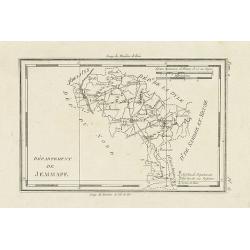
Département de Jemmape.
Map representing the area around Mons, with a short key list in the lower right corner.From Atlas de la Géographie de toutes les parties du monde .. Ouvrage destiné pou...
- $30 / ≈ €25
Date: Paris, Prudhomme, Levrault, Debray, 1806
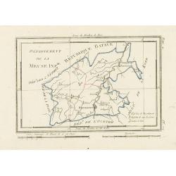
Département de la Meuse Inf.re.
Map representing the area around Maastricht, with a short key list in the lower right corner.From Atlas de la Géographie de toutes les parties du monde .. Ouvrage destin...
- $40 / ≈ €34
Date: Paris, Prudhomme, Levrault, Debray, 1806
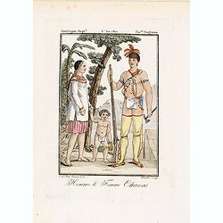
Homme & Femme Ottawas.
Hand-colored mezzotint of Native Americans engraved by Félix Mixelle and Lachaussée Jeune after Jacques Grasset de Saint-Sauveur.As an etcher, drawer and writer, Grasse...
- $75 / ≈ €64
Date: Paris,1801-1806
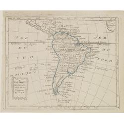
L'Amérique Méridionale, Divisée en ses Principaux Etats.
Map of South America, from Atlas de la Géographie de toutes les parties du monde .. Ouvrage destiné pour l'education, et nécessaire aux négocians, aux voyageurs, aux ...
Date: Paris, Prudhomme, Levrault, Debray, 1806
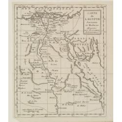
Carte de l'Egypte Ancienne et Moderne..
Map of Egypt illustrating part of the course of the river Nile. From Atlas de la Géographie de toutes les parties du monde .. Ouvrage destiné pour l'education, et néce...
Date: Paris, Prudhomme, Levrault, Debray, 1806
L'Empire de la Chine, avec les Isles du Japon, et la Corée.
Map of south eastern China, including Taiwan, Korea and Japan. From Atlas de la Géographie de toutes les parties du monde .. Ouvrage destiné pour l'education, et néces...
Date: Paris, Prudhomme, Levrault, Debray, 1806
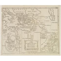
Carte des Régions et des Lieux dont il est parlé dans le Nouveau Testament.
Map of the eastern part of the Mediterranean with its hinterland. In the lower corners two inset maps: a plan of Jerusalem in the lower left, a map of Judea or Palestine ...
Date: Paris, Prudhomme, Levrault, Debray, 1806
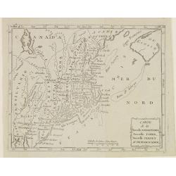
Carte de la Nouvelle Angleterre, Nouvelle York, Nouvelle Jersey, et Pensilvanie.
Map of the north eastern part of the United States, from Atlas de la Géographie de toutes les parties du monde .. Ouvrage destiné pour l'education, et nécessaire aux n...
Date: Paris, Prudhomme, Levrault, Debray, 1806
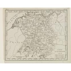
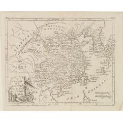
Carte d'Allemagne et de la Republique Helvetique.
Map of central Europe centered on Germany, extending southwards and eastwards to include Poland, the Czech Republic, Austria, Switzerland, Slovenia and part of Italy.From...
Date: Paris, Prudhomme, Levrault, Debray, 1806
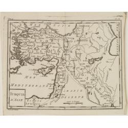
Turquie d'Asie.
Map of Turkey, including Cyprus and part of the Near East. From Atlas de la Géographie de toutes les parties du monde.. Ouvrage destiné pour l'education, et nécessaire...
Date: Paris, Prudhomme, Levrault, Debray, 1806
L'Afrique Divisée en ses Principaux Etats.
Map of Africa, from Atlas de la Géographie de toutes les parties du monde.. Ouvrage destiné pour l'education, et nécessaire aux négocians, aux voyageurs, aux fonction...
Date: Paris, Prudhomme, Levrault, Debray, 1806
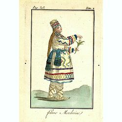
Femme Mordivine.
Originally hand-colored mezzotint of a Mordvinian woman from Ural region dressed in native garb, engraved by Félix Mixelle and Lachaussée Jeune after Jacques Grasset de...
Date: Paris,1801-1806
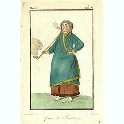
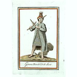
Femme de Barabinze.
Originally hand-colored mezzotint of a woman from Barabinze, engraved by Félix Mixelle and Lachaussée Jeune after Jacques Grasset de Saint-Sauveur.As an etcher, drawer ...
Date: Paris,1801-1806
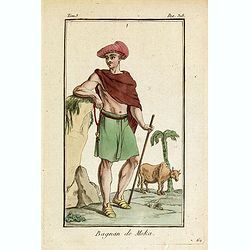
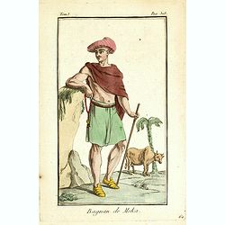
Bagnan de Moka.
Originally hand-colored mezzotint of a man in Banyan costume in Mocha, Yemen engraved by Félix Mixelle and Lachaussée Jeune after Jacques Grasset de Saint-Sauveur.As an...
- $25 / ≈ €21
Date: Paris,1801-1806
Bagnan de Moka.
Originally hand-colored mezzotint of a Banyan costume in Mocha, Yemen engraved by Félix Mixelle and Lachaussée Jeune after Jacques Grasset de Saint-Sauveur.As an etcher...
Date: Paris,1801-1806
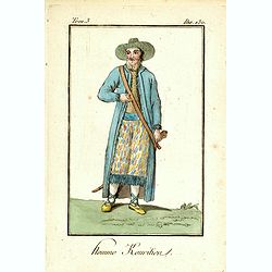
Homme Kouritien.
Originally hand-colored mezzotint of a Siberian man dressed in native garb, engraved by Félix Mixelle and Lachaussée Jeune after Jacques Grasset de Saint-Sauveur.As an ...
Date: Paris,1801-1806
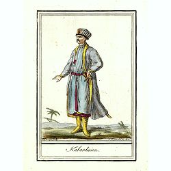
Kabardinien.
Originally hand-colored costume mezzotint of a Kabardian from the Northwest Caucasus, engraved by Félix Mixelle and Lachaussée Jeune after Jacques Grasset de Saint-Sauv...
Date: Paris,1801-1806
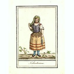
Kabardinienne.
Originally hand-colored costume mezzotint of a Kabardian woman from the Northwest Caucasus, engraved by Félix Mixelle and Lachaussée Jeune after Jacques Grasset de Sain...
Date: Paris,1801-1806
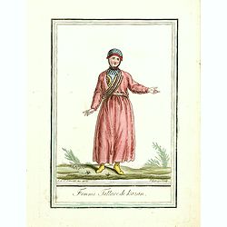
Femme Tattare de Kazan.
Originally hand-colored costume mezzotint of a Kazakhstan women engraved by Félix Mixelle and Lachaussée Jeune after Jacques Grasset de Saint-Sauveur.As an etcher, draw...
Date: Paris,1801-1806
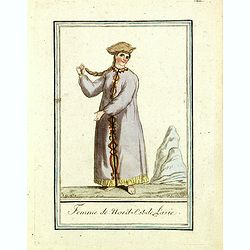
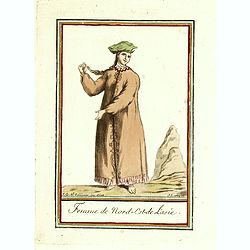
Femme du nord est de l'Asie.
Originally hand-colored mezzotint of a woman from Nord East Russia engraved by Félix Mixelle and Lachaussée Jeune after Jacques Grasset de Saint-Sauveur.As an etcher, d...
Date: Paris,1801-1806
Homme nord est de l'Asie.
Originally hand-colored mezzotint of Native Americans engraved by Félix Mixelle and Lachaussée Jeune after Jacques Grasset de Saint-Sauveur.As an etcher, drawer and wri...
- $50 / ≈ €42
Date: Paris,1801-1806
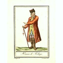
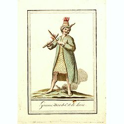
Homme de Kaluga.
Originally hand-colored costume mezzotint of a man from Kaluga engraved by Félix Mixelle and Lachaussée Jeune after Jacques Grasset de Saint-Sauveur.As an etcher, drawe...
Date: Paris,1801-1806
Femme de la Carie.
Originally hand-colored mezzotint costume plate of a woman from the Republic of Karelia, engraved by Félix Mixelle and Lachaussée Jeune after Jacques Grasset de Saint-S...
Date: Paris,1801-1806
Femme de nord ets de l'Asie.
Originally hand-colored mezzotint of a woman from Nord West Asia engraved by Félix Mixelle and Lachaussée Jeune after Jacques Grasset de Saint-Sauveur.As an etcher, dra...
Date: Paris,1801-1806
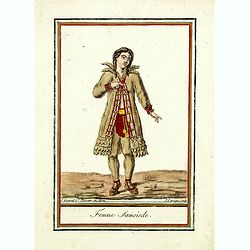
Femme Samoïede.
Originally hand-colored mezzotint of a Samoïede woman engraved by Félix Mixelle and Lachaussée Jeune after Jacques Grasset de Saint-Sauveur.As an etcher, drawer and wr...
Date: Paris,1801-1806
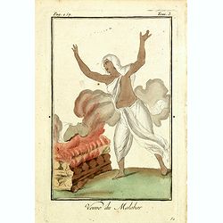
Venue du Malabar.
Originally hand-colored mezzotint of a widow of Malabar engraved by Félix Mixelle and Lachaussée Jeune after Jacques Grasset de Saint-Sauveur.As an etcher, drawer and w...
Date: Paris,1801-1806
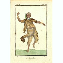
Bayadere.
Originally hand-colored mezzotint of a Temple Dancer engraved by Félix Mixelle and Lachaussée Jeune after Jacques Grasset de Saint-Sauveur.As an etcher, drawer and writ...
Date: Paris,1801-1806
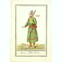
Homme Tartare d'Usbec.
Originally hand-colored costume mezzotint of a man from Uzbekistan engraved by Félix Mixelle and Lachaussée Jeune after Jacques Grasset de Saint-Sauveur.As an etcher, d...
Date: Paris,1801-1806
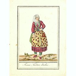
Femme Tartare d'Usbec.
Originally hand-colored costume mezzotint of a woman from Uzbekistan engraved by Félix Mixelle and Lachaussée Jeune after Jacques Grasset de Saint-Sauveur.As an etcher,...
Date: Paris,1801-1806
Homme-nord-est de l'Asie.
Originally hand-colored costume mezzotint of a man of Nord East Russia engraved by Félix Mixelle and Lachaussée Jeune after Jacques Grasset de Saint-Sauveur.As an etche...
- $25 / ≈ €21
Date: Paris,1801-1806

Siberie ou Russie Asiatique, Tartarie Chinoise, Pays des Eluts et Isles du Japon.
Map of the Kamchatka peninsula, Russian Far East., Korea, Japan, with Hokkaido labeled "Terre del Jeso".By C. F. Delamarche, successor of Robert de Vaugondy, Ge...
Date: Paris, 1794 - 1806
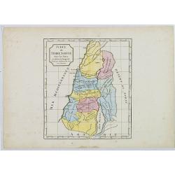
Judée ou Terre Sainte.
Map of the Holy Land, Judea. By C. F. Delamarche, successor of Robert de Vaugondy, Geographer.
- $75 / ≈ €64
Date: Paris, 1794 -1806
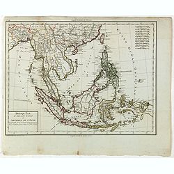
Presqu'Île au dela du Gange et Archipel de l'Inde.
Detailed map of Indonesia with Philippines and Taiwan. Engraved by P.F.Tardieu. From "Mentelle's Atlas Universe".
- $150 / ≈ €127
Date: Paris, ca 1784 / 1806
![Fille Mordwine en habits de nôces [together with] Fille Mordwine.](/uploads/cache/36932-250x250.jpg)
Fille Mordwine en habits de nôces [together with] Fille Mordwine.
Set of two originally hand-colored mezzotints of Native Russians engraved by Félix Mixelle and Lachaussée Jeune after Jacques Grasset de Saint-Sauveur.As an etcher, dra...
- $50 / ≈ €42
Date: Paris,1801-1806
![Femme Baschkir [together with] Homme Baschkir.](/uploads/cache/36933-250x250.jpg)
Femme Baschkir [together with] Homme Baschkir.
Set of two originally hand-colored mezzotints of Native Russians engraved by Félix Mixelle and Lachaussée Jeune after Jacques Grasset de Saint-Sauveur.As an etcher, dra...
- $50 / ≈ €42
Date: Paris,1801-1806
![Kirguise [together with] Fille Fatar Kastchintz.](/uploads/cache/36937-250x250.jpg)
Kirguise [together with] Fille Fatar Kastchintz.
Set of two originally hand-colored mezzotints of Native Russians engraved by Félix Mixelle and Lachaussée Jeune after Jacques Grasset de Saint-Sauveur.As an etcher, dra...
- $50 / ≈ €42
Date: Paris,1801-1806
![Homme Fatar Kastchintz [together with] Femme Fatar Kastchintz.](/uploads/cache/36938-250x250.jpg)
Homme Fatar Kastchintz [together with] Femme Fatar Kastchintz.
Set of two originally hand-colored mezzotints of Native Russians engraved by Félix Mixelle and Lachaussée Jeune after Jacques Grasset de Saint-Sauveur.As an etcher, dra...
- $50 / ≈ €42
Date: Paris,1801-1806
![Homme de Tobolsk [together with] Femme Fatar Tobolsk.](/uploads/cache/36939-250x250.jpg)
Homme de Tobolsk [together with] Femme Fatar Tobolsk.
Set of two originally hand-colored mezzotints of Native Russians engraved by Félix Mixelle and Lachaussée Jeune after Jacques Grasset de Saint-Sauveur.As an etcher, dra...
- $50 / ≈ €42
Date: Paris,1801-1806
![Homme Morwine [together with] Femme Mordwine.](/uploads/cache/36920-250x250.jpg)
Homme Morwine [together with] Femme Mordwine.
Set of two originally hand-colored mezzotints of Native Russians engraved by Félix Mixelle and Lachaussée Jeune after Jacques Grasset de Saint-Sauveur.As an etcher, dra...
- $50 / ≈ €42
Date: Paris,1801-1806
![Femme Tscheremisse [together with] Homme Tscheremisse.](/uploads/cache/36921-250x250.jpg)
Femme Tscheremisse [together with] Homme Tscheremisse.
Set of two originally hand-colored mezzotints of Native Russians engraved by Félix Mixelle and Lachaussée Jeune after Jacques Grasset de Saint-Sauveur.As an etcher, dra...
- $50 / ≈ €42
Date: Paris,1801-1806
![Homme Kamtschadale [together with] Femme Kamtschadale.](/uploads/cache/36922-250x250.jpg)
Homme Kamtschadale [together with] Femme Kamtschadale.
Set of two originally hand-colored mezzotints of Native Russians engraved by Félix Mixelle and Lachaussée Jeune after Jacques Grasset de Saint-Sauveur.As an etcher, dra...
Date: Paris,1801-1806
![Femme Samoïede [together with] Homme Samoïede.](/uploads/cache/36923-250x250.jpg)
Femme Samoïede [together with] Homme Samoïede.
Set of two originally hand-colored mezzotints of Native Russians engraved by Félix Mixelle and Lachaussée Jeune after Jacques Grasset de Saint-Sauveur.As an etcher, dra...
- $50 / ≈ €42
Date: Paris,1801-1806
![Femme Ostyack [together with] Homme Ostyack.](/uploads/cache/36924-250x250.jpg)
Femme Ostyack [together with] Homme Ostyack.
Set of two originally hand-colored mezzotints of Native Russians engraved by Félix Mixelle and Lachaussée Jeune after Jacques Grasset de Saint-Sauveur.As an etcher, dra...
- $50 / ≈ €42
Date: Paris,1801-1806
![Kabardinien [together with] Kabardinienne.](/uploads/cache/36925-250x250.jpg)
Kabardinien [together with] Kabardinienne.
Set of two originally hand-colored mezzotints of Native Russians engraved by Félix Mixelle and Lachaussée Jeune after Jacques Grasset de Saint-Sauveur.As an etcher, dra...
- $50 / ≈ €42
Date: Paris,1801-1806
![Homme Jacout [together with] Femme Jacout.](/uploads/cache/36928-250x250.jpg)
Homme Jacout [together with] Femme Jacout.
Set of two originally hand-colored mezzotints of Native Russians engraved by Félix Mixelle and Lachaussée Jeune after Jacques Grasset de Saint-Sauveur.As an etcher, dra...
- $50 / ≈ €42
Date: Paris,1801-1806
![Homme Tongouse [together with] Femme Tongouse.](/uploads/cache/36929-250x250.jpg)
Homme Tongouse [together with] Femme Tongouse.
Set of two originally hand-colored mezzotints of Native Russians engraved by Félix Mixelle and Lachaussée Jeune after Jacques Grasset de Saint-Sauveur.As an etcher, dra...
- $50 / ≈ €42
Date: Paris,1801-1806