Browse Listings
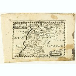
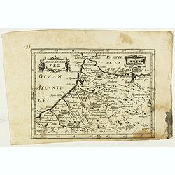
Le Royaume de Marroc.
Rare map of Morocco published by Jollain in 1667. Published in "Trésor Des Cartes Geographiques Des Principaux Estats de Lunivers".This atlas is based upon Boi...
- $100 / ≈ €85
Date: Paris, 1667
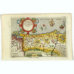
Pomeraniae Wandalice Regionis Tipus.
Miniature map of Pomerania embellished by rich cartouche, vessel and sea monsters in the Baltic. Abraham Ortelius (1527-1598) was a cartographer and publisher, who is bor...
- $250 / ≈ €212
Date: Antwerp, 1667
Espagne. . .
Map of Spain and Portugal prepared by N.Sanson and published by Pierre Mariette.Published in an early edition of the small Sanson atlas L'Europe Dediée a Monseigneur . ....
Date: Paris, P. Mariette, 1667

La Chine.
Rare map of China, Korea (as an island) and Japan, published by Jollain in 1667. In upper right corner part of North America. Published in "Trésor Des Cartes Geogra...
- $350 / ≈ €296
Date: Paris, 1667
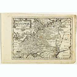
Russie Blanche ou Moscovie.
Map of the European part of Russia prepared by N.Sanson and published by Pierre Mariette.Published in an early edition of the small Sanson atlas L'Europe Dediée a Monsei...
Date: Paris, P. Mariette, 1667
Le Royaume de Fez.
Rare map of Morocco published by Jollain in 1667. Published in "Trésor Des Cartes Geographiques Des Principaux Estats de Lunivers".This atlas is based upon Boi...
- $150 / ≈ €127
Date: Paris, 1667
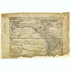
Nouvelle description de lamerique.
Jollain published this rare map of America in 1667. State 3, with the scale, erased, as it fictitious strait on the west coast of North America which Le Royaume de Quiuer...
- $450 / ≈ €381
Date: Paris, 1667
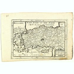
Natolie ou Asie mineur, Lieües d'Alemag.
Rare map of Turkey and Cyprus published by Jollain in 1667. Published in "Trésor Des Cartes Geographiques Des Principaux Estats de Lunivers".This atlas is base...
- $250 / ≈ €212
Date: Paris, 1667
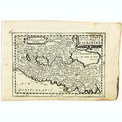
Terre Sainte jadis Terre Promise ou Palestine.
Rare map of the Holy Land published by Jollain in 1667. Published in "Trésor Des Cartes Geographiques Des Principaux Estats de Lunivers".This atlas is based up...
- $300 / ≈ €254
Date: Paris, 1667
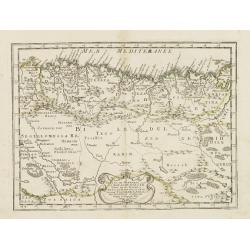
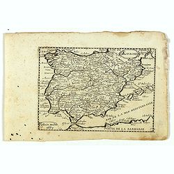
Partie de la Barbarie ou sont les royaumes de Tunis et Tripoli. . .
Coastal map of Tunisia and Libya prepared by N.Sanson and published by Pierre Mariette.Published in an early edition of the small Sanson atlas L'Europe Dediée a Monseign...
- $750 / ≈ €635
Date: Paris, P. Mariette, 1667
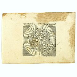
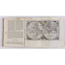
Le monde et sa disposition suivant Ptolomée.
The Christian Aristotelian cosmos. Ptolemy accepted the following order for celestial objects in the solar system: Earth (center), Moon, Mercury, Venus, Sun, Mars, Jupite...
- $150 / ≈ €127
Date: Paris, 1667
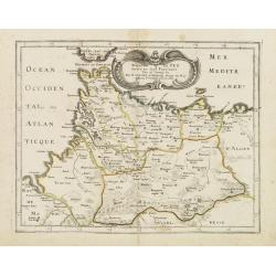
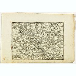
Partie de la Barbarie ou est le royaume d'Alger. . .
Coastal map of North Africa prepared by N.Sanson and published by Pierre Mariette.Published in an early edition of the small Sanson atlas L'Europe Dediée a Monseigneur ....
- $80 / ≈ €68
Date: Paris, P. Mariette, 1667
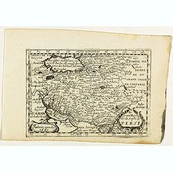
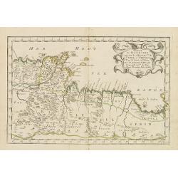
Le grand Royaume du Sophi de Perse.
Rare map of Persia with present-day Iran and Iraq published by Jollain in 1667. Published in "Trésor Des Cartes Geographiques Des Principaux Estats de Lunivers"...
- $250 / ≈ €212
Date: Paris, 1667
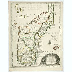
Isle D'Auphine, communement Nommée pae les Europeens Madagascar. . .
One of the most UpToDate maps of Madagascar, also showing the Comoros Islands in the North West and the Reunion Island in the South East.With decorative title cartouche r...
- $900 / ≈ €762
Date: Paris, 1667
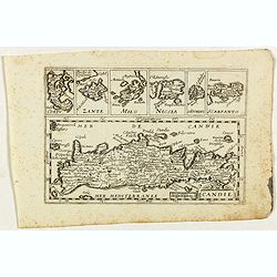
Candie.
Rare map of Crete with in top six small inset maps of Greek islands, published by Jollain in 1667. Published in "Trésor Des Cartes Geographiques Des Principaux Esta...
- $350 / ≈ €296
Date: Paris, 1667
Portugal et Algarve.
Rare map of Portugal, published by Jollain in 1667. Published in "Trésor Des Cartes Geographiques Des Principaux Estats de Lunivers".This atlas is based upon B...
- $150 / ≈ €127
Date: Paris, 1667
Asie.
Rare map of Asia, published by Jollain in 1667. The name of Korea placed in the sea in between Korea and Japan. In top right part of North America. Published in "Tr�...
- $400 / ≈ €339
Date: Paris, 1667
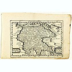
Moree jadis Peloponese.
Rare map of Peloponnese, published by Jollain in 1667. Published in "Trésor Des Cartes Geographiques Des Principaux Estats de Lunivers".This atlas is based upo...
- $300 / ≈ €254
Date: Paris, 1667
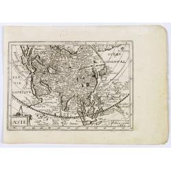
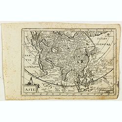
Asie.
This rare map of Asia was published by Jollain in 1667. Published in "Trésor Des Cartes Geographiques Des Principaux Estats de Lunivers".This atlas is based up...
Date: Paris, 1667
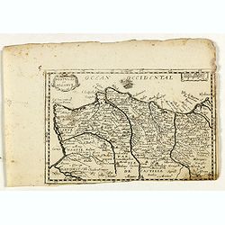
Royaume de Fez. . .
Map of Morocco prepared by N.Sanson and published by Pierre Mariette.Published in an early edition of the small Sanson atlas L'Europe Dediée a Monseigneur . . . Le Telli...
- $120 / ≈ €102
Date: Paris, P. Mariette, 1667
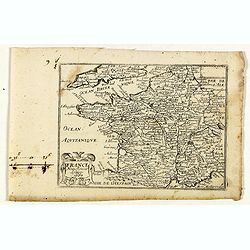
France nouvellement descripte.
Rare map of France, published by Jollain in 1667. Published in "Trésor Des Cartes Geographiques Des Principaux Estats de Lunivers".This atlas is based upon Boi...
- $150 / ≈ €127
Date: Paris, 1667
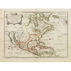
Americque Septentrionale. . .
A general map of North America shows California as an island, but with few names and a flat northern coastline. Prepared by N. Sanson and engraved by A.Peyrounin. A firs...
- $1000 / ≈ €847
Date: Paris, P. Marriete, 1667
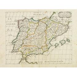
Espagne.
Rare map of Spain and Portugal, published by Jollain in 1667. Published in "Trésor Des Cartes Geographiques Des Principaux Estats de Lunivers".This atlas is ba...
- $200 / ≈ €169
Date: Paris, 1667
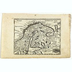
Norvege et Suede.
Rare map of Norway, Sweden and Finmark published by Jollain in 1667. Published in "Trésor Des Cartes Geographiques Des Principaux Estats de Lunivers".This atla...
- $250 / ≈ €212
Date: Paris, 1667
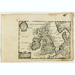
Angleterre Ecosse et Hibernie.
Rare map of the British islands, published by Jollain in 1667. Published in "Trésor Des Cartes Geographiques Des Principaux Estats de Lunivers".This atlas is b...
- $250 / ≈ €212
Date: Paris, 1667
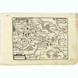
Russie.
Rare map of Russia, published by Jollain in 1667. Published in "Trésor Des Cartes Geographiques Des Principaux Estats de Lunivers".This atlas is based upon Boi...
- $250 / ≈ €212
Date: Paris, 1667
Moscovie avec ses confins.
Rare map of Russia, published by Jollain in 1667. Published in "Trésor Des Cartes Geographiques Des Principaux Estats de Lunivers".This atlas is based upon Boi...
- $450 / ≈ €381
Date: Paris, 1667
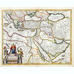
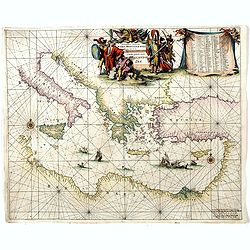
Turcicum Imperium. Concordia res parvæ crescunt discordia maximæ dilabuntur.
An impressive and attractive map with a particularly fine cartouche showing the Turkish Sultan on his throne and allegorical figures at either side brandishing weapons.Sa...
- $1100 / ≈ €932
Date: Amsterdam, 1667
Hongrie.
Rare map of Hungary, published by Jollain in 1667. Published in "Trésor Des Cartes Geographiques Des Principaux Estats de Lunivers".This atlas is based upon Bo...
- $300 / ≈ €254
Date: Paris, 1667
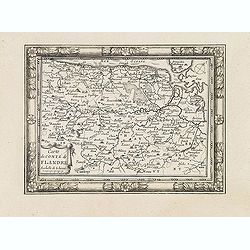
Carte du Comté de Flandre. . .
Decorative map of Flanders from Plans, et Profils des principales villes.. by Ch. De Beaulieu. Etched by mr. Romeijn de Hooghe.
- $80 / ≈ €68
Date: Paris, 1668
![[Title page] Les Plans et Profils des principales Villes et lieux considérables Du Duché de Gueldre. . .](/uploads/cache/33213-250x250.jpg)
[Title page] Les Plans et Profils des principales Villes et lieux considérables Du Duché de Gueldre. . .
Decorative title page from Plans, et Profils des principales villes.. by Ch. De Beaulieu. Etched by mr. Romeijn de Hooghe.
Date: Paris, 1668
![[Title page] Les Plans et Profils des principales Villes et lieux considérables du Comté de Flandre. . .](/uploads/cache/33218-250x250.jpg)
[Title page] Les Plans et Profils des principales Villes et lieux considérables du Comté de Flandre. . .
Decorative title page from Plans, et Profils des principales villes.. by Ch. De Beaulieu. Etched by mr. Romeijn de Hooghe.
- $80 / ≈ €68
Date: Paris, 1668

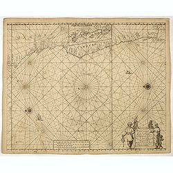
Paskaart van Guinea van C.Verde tot R. deGalion.
Rare edition of Doncker's sea chart of Guinea coast. From an atlas printed in 1668, "l'Atlas de MER ou MONDE AQUATIQUE, Remontrant toutes lescôtes de la Mer…"...
- $1000 / ≈ €847
Date: Amsterdam, 1660-1668
Pascaart van de zee-custenvan Angola, en Cimbedas van Rivier de Galion tot C. de Bona Esperanca.
Rare Doncker's sea chart of the West Coast of Africa, from Angola to the Cape of Good Hope, with a larger inset map of the area from St. Martin's Bay to the Cape of Good ...
Date: Amsterdam, 1660-1668
![[Title page] Les Plans et Profils des principales Villes du Comté de Namur. . .](/uploads/cache/33217-250x250.jpg)
[Title page] Les Plans et Profils des principales Villes du Comté de Namur. . .
Decorative title page from Plans, et Profils des principales villes.. by Ch. De Beaulieu. Etched by mr. Romeijn de Hooghe.More about title pages [+]
- $80 / ≈ €68
Date: Paris, 1668
![[Title page] Les Plans et Profils des principales Villes et lieux considérables du Comté de Haynaut. . .](/uploads/cache/33216-250x250.jpg)
[Title page] Les Plans et Profils des principales Villes et lieux considérables du Comté de Haynaut. . .
Decorative title page from Plans, et Profils des principales villes.. by Ch. De Beaulieu. Etched by mr. Romeijn de Hooghe.
- $80 / ≈ €68
Date: Paris, 1668
![[Title page] Les Plans et Profils des principales Villes et lieux considérables Du Duché de Brabant. . .](/uploads/cache/33214-250x250.jpg)
[Title page] Les Plans et Profils des principales Villes et lieux considérables Du Duché de Brabant. . .
Decorative title page from Plans, et Profils des principales villes.. by Ch. De Beaulieu. Etched by mr. Romeijn de Hooghe.
- $80 / ≈ €68
Date: Paris, 1668

Impery sino Tartarici Supremus Monarcha.
Decorative costume plate showing Kam Hi son of the Shunzhi Emperor of China [1638 - 1661?], the second emperor of the Manchu Qing dynasty, who apparently supported the fo...
Date: Amsterdam, 1668

Pascaart van de west cust van Engeland en Wales Van S. Davids Point tot de Moul van Dalway.
Rare Doncker's sea chart of the Irish Sea with the west Coast of England (Liverpool), the Island of Man and the western-most tip of Northern Ireland (Bangor) and Souther...
Date: Amsterdam, 1660-1668
(Title page) Plans et Profils des principales Villes des Duchez de Loraine et de Bar. . .
Decorative title page by Ch. De Beaulieu.
- $80 / ≈ €68
Date: Paris, 1668

Diverses cartes et tables pour la géographie ancienne, pour la chronologie et pour les itinéraires et voyages modernes.
Edition without date. Variant edition containing three parts : "Cartes géographiques dressées pour bien entendre les Historiens… / La Chronologie en plusieurs Ta...
Date: Paris, l'Auteur, no date ca.1669

Paskaerte Zynde t'Oosterdeel Van Oost Indien, met alle de Eylanden daer ontrendt geleegen van C. Comorin tota aen Iapan.
An eye-catching chart of Pieter Goos' sea chart of Australia, Southeast Asia, China, Japan, Korea and India. The chart shows the regions from Cape Comorin (Southern India...
Date: Amsterdam, 1669

An embassy from the East-India Company of the United Provinces, to the Grand Tartar Cham, Emperor of China deliver'd by their excellencies, Peter de Goyer and Jacob de Keyzer, at his imperial city of Peking. . .
Very rare first English text edition of this most important and early resource on China and the Chinese. Three parts in one folio by John Macock for the author.Part I: An...
Date: London : Printed by the Author at his house in White-Friers, 1669
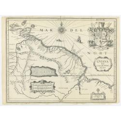
Guiana sive Amazonum regio.
This very rare map shows northwest Latin America with Surinam and French Guiana and was engraved by Johann Philipp Thelott. The map comes from the work of Johann Joachim ...
Date: Frankfurt, 1669

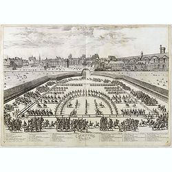
Course de Baque et Disposition des Quadrilles, dans l'Amphiteatre seconde journée.
An early and intriguing engraving recording one of the most celebrated and spectacular festivals held at Paris by the young Louis XIV. The multi-day tournament took place...
Date: Paris, imprimerie royale, 1670
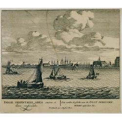
Een ander gesicht van de Oost Indische Werf: uyt het Ye.
Decorative engraving giving good detail of the entrance of the IJ with in the background the ship building wharf of the V.O.C. and its ware house, presently the Maritime ...
Date: Amsterdam, 1670
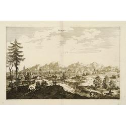
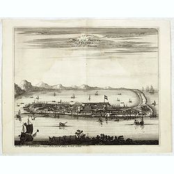
Peking.
Fine panoramic view of Peking. From Olfert Dapper mission to China, 1662-1663. Printed by Jacob van Meurs, title of the book: Gedenckwaerdig bedrijf der Nederlandsche Oos...
- $200 / ≈ €169
Date: Amsterdam, 1670

La Chine d'Athanase Kirchere de la compagnie de Jesus, illustrée de plusieurs monuments tant sacrés que profanes et de quantité de recherches de la nature. . .
Athanasius Kircher, S.J., (1601 or 1602-1680) was a 17th-century German Jesuit scholar who published around 40 works, most notably in the fields of oriental studies, geol...
Date: Amsterdam, 1670
L’Atlas de la Mer ou Monde aquaticque.
Original blind-stamped vellum binding; attractive ORIGINAL HAND-COLOR in outline with cartouches, windroses and decoration in full original color; internally some usual m...
Date: Amsterdam, sur le Cay de Teexel, prez du Rams-Koy, au miroir de la Mer, 1670
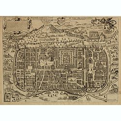
Jerusalem comme elle estoit du temps que nostre Sauveur Jesus-Christ souffrit mort et passion pour nous.
Rare and decorative view imaginary plan of ancient Jerusalem and its suburbs published by Gérard Jollain after Christian van Adrichom (1533-1595) plan.The plan itself is...
Date: Paris, ca.1670

Canibales Insulae.
Rare, early Dutch nautical chart of the Caribbean from Puerto Rico southward.
Date: Amsterdam, 1670
Comparse des Cinq Quadrilles dans l'Amphitheatre.
An early and intriguing engraving recording one of the most celebrated and spectacular festivals held at Paris by the young Louis XIV. The multi-day tournament took place...
Date: Paris, imprimerie royale, 1670
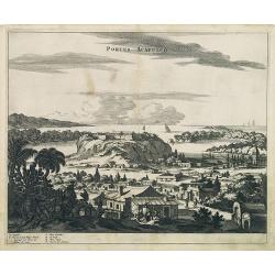
Portus Acapulco.
Attractive view of the city and harbor of Acapulco, showing fortifications, outlying buildings, ships in the harbor, costumed locals, etc.This map is taken from Ogilby's ...
- $300 / ≈ €254
Date: London, 1671
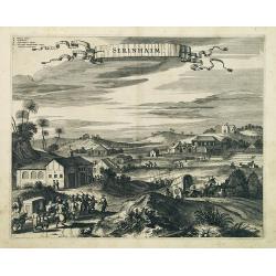
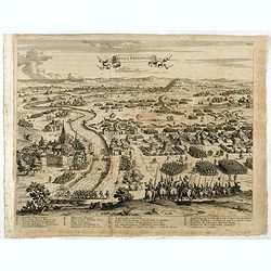
Serinhaim.
Fine view of a fort in Serinhaim, Brazil, with numbered key at the base. A procession of Portuguese or Dutch soldiers advance along the road carrying a litter. To the lef...
Date: London, 1671
![Nova & exacta Chorographia Latii sive Territorii Romani iuxta veterem et novum situm parallela nomimu[m] comparatione elaborata.](/uploads/cache/44863-250x250.jpg)
Nova & exacta Chorographia Latii sive Territorii Romani iuxta veterem et novum situm parallela nomimu[m] comparatione elaborata.
Map of central Italy, centered on Rome from "Latium" by A. Kircher and designed by Innocenzo Mattei. The title cartouche in the lower right, small legend with 1...
Date: Amsterdam, 1671

Nova Virginia Tabula.
A beautifully engraved map, derived from the highly influential map by Captain John Smith in 1612, showing Chesapeake Bay and the surrounding area. The decoration of this...
Date: Amsterdam, J.Meurs, 1671
![[Title page to] Atlas mayor, o geographia Blaviana : Que contiene las cartas, y descripciones de Partes Orientales de Europa.](/uploads/cache/29952-250x250.jpg)
[Title page to] Atlas mayor, o geographia Blaviana : Que contiene las cartas, y descripciones de Partes Orientales de Europa.
Title page from a Spanish text edition of the Atlas Major. Ionic portico with celestial and terrestrial globes. To the left is Ptolemy with a sphere and a pair of compass...
Date: Amsterdam, c.1672
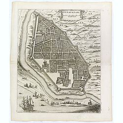
Negapatam.
Bird's-eye view of Nagapattinam or Negapatam, India, printed for the first Dutch edition of Baldaeus' work "A true and exact description of the most celebrated East-...
- $200 / ≈ €169
Date: Amsterdam, 1672
Petites tables Geneologiques touchant les droits et les interests des Princes.
Compilation of Duval's Pocket Atlas, with an archbishoprics and dioceses description of the world, here right at the beginning with the rare genealogical tables of variou...
- $3000 / ≈ €2541
Date: Paris, P. Duval, ca. 1667-1672
![[Illustration from Hierusalemsche Reyse.] Interieur of Church of the Holy Sepulchre.](/uploads/cache/30796-250x250.jpg)
[Illustration from Hierusalemsche Reyse.] Interieur of Church of the Holy Sepulchre.
Interior of a Church of the Holy Sepulchre. Below a decorative cartouche with lettered key and surrounded by 2 cherubins.Taken from a very rare travel book by Anthonius G...
- $30 / ≈ €25
Date: Antwerpen, Michiel Cnobbaert, 1673

Yucatan . . . Et Guatimala Conventus Iuridicus.
Very attractive map encompassing the Mexican heartland, the Yucatan peninsula, and the old Spanish Audiencia of Guatemala including Honduras, Nicaragua, Costa Rica and pa...
Date: Amsterdam, 1673

Brasila.
Map of Brazil extending from C. Nasou and Parime Lago to the Mouth of the Rio de la Plata. Oriented with West on top.The cartography of the region is quite primitive. The...
Date: Amsterdam, 1673

Turckschemoniken die onder den goddelycken. . .
Decorative picture of three dervishes dancers. Their whirling dance, also known as the sema, is a serious religious ritual performed by Muslim priests in a prayer trance ...
Date: Antwerpen, Michiel Cnobbaert, 1673
![[Title page from ] Ierusalemsche Reyse.](/uploads/cache/30784-250x250.jpg)
[Title page from ] Ierusalemsche Reyse.
Decorative title page with 2 views of Jerusalem flanked by S. Franciscus and S. Helena. From a very rare travel book by Anthonius Gonsales, "Hierusalemsche Reyse&quo...
- $50 / ≈ €42
Date: Antwerpen, Michiel Cnobbaert, 1673
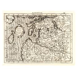
Livonia.
Finely engraved map of the Baltic states Estonia and Latvia filled with forests, rivers and lakes. French text on verso. Engraved by Petrus Kaerius for Janssonius' pocket...
Date: Amsterdam, Jan Cloppenburgh, 1673
La Souabe.
Fine map of Swabia.This edition carries the date 1674 and the publishers address A PARIS chez l'Autheur aux Galleries du Louvre. Nicolas Sanson was to bring about the ris...
- $75 / ≈ €64
Date: Paris, 1674

Recueil de divers voyages faits en Afrique et en l'Amerique, qui n'ont point esté encore publiez.
First edition of this collection of significant and interesting voyages, edited by a scholar and book collector who served in the employ of Louis XIV before being appoint...
Date: Paris, Louis Billaine, 1674
The siege of Lagny.
Very rare etching of the siege of Lagny-sur-Marne by the Duc of Parma. Etched by Johann Azelt (1654-1692). A similar print but with the number in the upper right corner i...
- $150 / ≈ €127
Date: Nuremberg, ca 1675
![[Lot of 8 maps and prints] Norvegiae Maritimae ab Elf-burgo ad Dronten / Pascaert van Noorwegen streckende van Elf-burg tot Dronten.](/uploads/cache/84130-250x250.jpg)
[Lot of 8 maps and prints] Norvegiae Maritimae ab Elf-burgo ad Dronten / Pascaert van Noorwegen streckende van Elf-burg tot Dronten.
Norvegiae Maritimae ab Elf-burgo ad Dronten / Pascaert van Noorwegen streckende van Elf-burg tot Dronten. Frederick de Wit's fine sea chart of southern Norway. An attr...
- $900 / ≈ €762
Date: Amsterdam, 1675
Orientalior districtus Maris Mediterranei.
Beautiful chart of the eastern part of the Mediterranean. Including Italy, the north coast of Africa and part of the Black Sea.The entire sheet is covered with rhumb line...
Date: Amsterdam, 1675
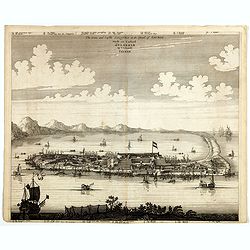
La Ville et le Château de Zélandia dans l' île de Tayovan.
This important copperplate engraving is one of the earliest European views of Taiwan, depicting the Dutch fortifications and trading settlement on the West coast of the i...
- $1800 / ≈ €1525
Date: Amsterdam, 1675
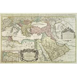
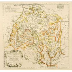
Les Estats De L'Empire Du Grand Seigneur Des Turcs En Europe. . .
Prepared by N.Sanson. The map represents the Ottoman Empire based on Sanson's 1654 map. The Arabian Peninsula is shown with much detail, including towns, villages, mounta...
Date: Paris, 1675

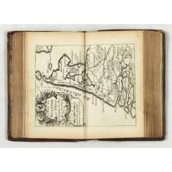
French composite atlas made up of rare maps published by Parisian editors from the 17th century , mainly by G. Jollain including scarce maps of America.
A rare French composite atlas including 90 maps, published by Parisian publishers from the 17th century, mainly by Gérard I Jollain, or by maps bought from Dutch publish...
Date: Paris, ca. 1675

Cimbebas et Caffariae Littora a Catenbela ad Promontorium. . .
The coast of Angola, South-West Africa and South Africa up to Port Elizabeth. Classic sea chart of Dutch school with excellent baroque embellishment. North oriented to th...
Date: Amsterdam, 1675
The citie and Castle Zelandia in the Island of Taywan. / Stadt en casteel Zelandia op 't Eilant Taywan.
This important copperplate engraving is one of the earliest European views of Taiwan, depicting the Dutch fortifications and trading settlements on the island's West coas...
Date: Amsterdam, 1675
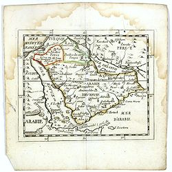
Arabie.
Scarce miniature map of the Arabian peninsular, from Pierre Duval's La Geographie Universeille dated 1676. Following his Cartes de géographie in 1657, Pierre Duval publi...
- $300 / ≈ €254
Date: Paris, 1676
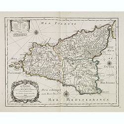
La Sicile, avec les anciens noms de presque toutes ses Places, Rivières, Chateaux &c. et diverses observations nouvelles . . .
Uncommon map of Sicily with fine title cartouche lower right . Original date of 1675 now altered to 1676.More about [+]
Date: Paris, 1676
Introductio in universam geographiam tam veterem, quám novam... et tabulis geographicis aucta studio & operâ Johannis Bunonis. . .
Engraved title with minor ink dash, title with former owner's signatures Joannes Steuchig, (could be the Swedish archbishop Johannes Steuchius (1676-1742). D. Hildebrand ...
- $3000 / ≈ €2541
Date: Amsterdam, 1676
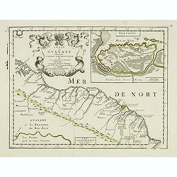
Coste de Guayane autrement Franc Equinoctale en la Terre-Ferme d'Amerique suivant les Dernières Relations . . .
Uncommon map of the French colony Guyana in southern American Guyana, with a detailed enlargement of Cayenne in the upper right corner ( 155X110mm.), with fine title cart...
Date: Paris, 1676

Paris, Lutetia, Parisii, Ville Capitale du Royaume de France.
View of Paris seen from the hill "Belleville based on that of Merian (1616) but updated with the new gates Saint-Denis and Saint-Martin. With a key 1-78 and A-Z. Sur...
Date: Paris, after 1676