Browse Listings
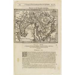
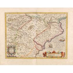
India Orientalis.
The rare Samuel Purchas' edition of the Mercator/Hondius Atlas Minor atlas map. Thisearly map of the East Indies was published in his famous collection of voyages His Pil...
- $300 / ≈ €256
Date: London, 1625
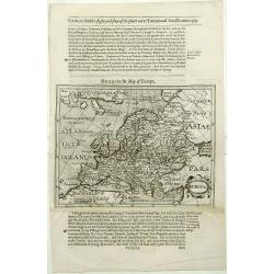
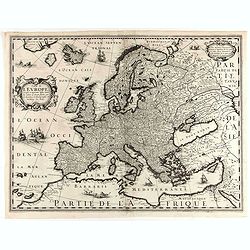
Europa.
The rare Samuel Purchas' edition of the Mercator/Hondius Atlas Minor atlas map. Early map of Europe published in his famous collection of voyages His Pilgrimes . With des...
- $150 / ≈ €128
Date: London, 1625
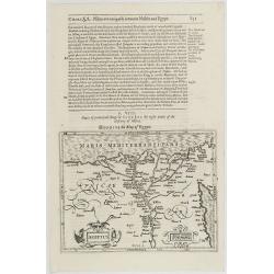
Aegyptus.
The rare Samuel Purchas' edition of the Mercator/Hondius Atlas Minor atlas map. Early map of Egypt published in his famous collection of voyages His Pilgrimes . With desc...
Date: London, 1625
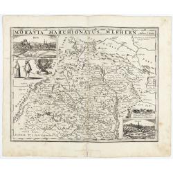
Moravia Marchionatus. Merhern.
Second state of this rare map by Pieter van den Keere, published by Abraham Janssonius with the following imprint added : “Abrahamus Janssonius Excud : 1625".The t...
- $1600 / ≈ €1367
Date: Amsterdam, Abrahamus Janssonius, 1625
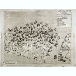
Le grand combat ov Monsieur de Montmorancy admiral de Fance . . .
Attractive view of the naval Battle of Saint-Martin de Ré, fought on 15 September 1625 between the Huguenot fleet of La Rochelle, commanded by Admiral Jean Guiton- Admir...
Date: Paris, 1625
![[No title] Tabla de la Europa. . . / Italie.](/uploads/cache/29264-250x250.jpg)
[No title] Tabla de la Europa. . . / Italie.
Page from a Mercator Atlas with letter press in Spanish illustrated with two maps. Recto a map of Europe (109x16mm.) and on verso a map of northern Italy (90x150mm).
- $230 / ≈ €197
Date: Amsterdam, c.1625
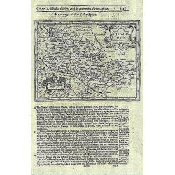
Hispania Nova.
The rare Samuel Purchas' edition of the Mercator/Hondius Atlas Minor atlas map. This was the standard map of the area for a generation. The map shows an area correspondin...
- $100 / ≈ €85
Date: London, 1625
![[Atrii Sancti ac Tabernaculi Foederisorthographia].](/uploads/cache/26474-250x250.jpg)
[Atrii Sancti ac Tabernaculi Foederisorthographia].
Campment in Israel.From an uncommon edition of Kerckelycke Historie van Neder-Landt which was a Dutch text edition of Agostino Torniello's Annales Sacri et Profani by Her...
- $50 / ≈ €43
Date: Holland, ca. 1625
![[Title page] Libellus Novus Politicus.. Pars Sexta.](/uploads/cache/38473-250x250.jpg)
[Title page] Libellus Novus Politicus.. Pars Sexta.
Very skilfully engraved title page from a rare work printed by Eberhard Kieser: Thesaurus Philo-Politicus. Das ist Politisches Schatzkästlein guter Herren und bestendige...
- $90 / ≈ €77
Date: Frankfurt, 1626
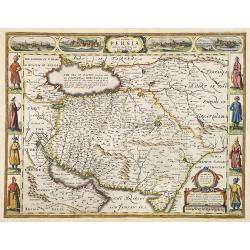
The Kingdom of Persia with the cheef Citties and Habites described by John Speede.
One of the most decorative "carte à figures"- maps of the old Kingdom of Persia, including modern day Iran and Iraq, as well as portions of the Turkish Empire,...
- $2000 / ≈ €1709
Date: London, G.Humble, 1626
![[Title page] Libellus Novus Politicus.. Pars Quarta.](/uploads/cache/38474-250x250.jpg)
[Title page] Libellus Novus Politicus.. Pars Quarta.
Very skilfully engraved title page from a rare work printed by Eberhard Kieser: Thesaurus Philo-Politicus. Das ist Politisches Schatzkästlein guter Herren und bestendige...
- $80 / ≈ €68
Date: Frankfurt, 1626
![[Title page] Libellus Novus Politicus.. Pars Spetima.](/uploads/cache/38508-250x250.jpg)
[Title page] Libellus Novus Politicus.. Pars Spetima.
Very skillfully engraved title page from a rare work printed by Eberhard Kieser: Thesaurus Philo-Politicus. Das ist Politisches Schatzkästlein guter Herren und bestendig...
Date: Frankfurt, 1626
![[Title page] Libellus Novus Politicus.. Pars Spetima.](/uploads/cache/38472-250x250.jpg)
[Title page] Libellus Novus Politicus.. Pars Spetima.
Very skilfully engraved title page from a rare work printed by Eberhard Kieser: Thesaurus Philo-Politicus. Das ist Politisches Schatzkästlein guter Herren und bestendige...
- $75 / ≈ €64
Date: Frankfurt, 1626
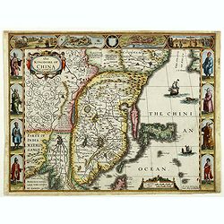
The Kingdome of China.
A most sought-after map of China. Decorative border vignettes including views of the cities of Quinzay and Macao along the top border with the wheeled wind machines and p...
Date: London, G. Humble, 1626
![[Title page] Thesauri Philo Politci pars septima. . .](/uploads/cache/35637-250x250.jpg)
[Title page] Thesauri Philo Politci pars septima. . .
Very skillfully engraved title page from a rare work printed by Eberhard Kieser: Thesaurus Philo-Politicus. Das ist Politisches Schatzkästlein guter Herren und bestendig...
- $90 / ≈ €77
Date: Frankfurt, 1626
![[Title page] Libellus Novus Politicus.. Pars Octava.](/uploads/cache/38483-250x250.jpg)
[Title page] Libellus Novus Politicus.. Pars Octava.
Very skilfully engraved title page from a rare work printed by Eberhard Kieser: Thesaurus Philo-Politicus. Das ist Politisches Schatzkästlein guter Herren und bestendige...
- $90 / ≈ €77
Date: Frankfurt, 1626
![[Title page] Libellus Novus Politicus.. Pars Quinta.](/uploads/cache/38479-250x250.jpg)
[Title page] Libellus Novus Politicus.. Pars Quinta.
Very skilfully engraved title page from a rare work printed by Eberhard Kieser: Thesaurus Philo-Politicus. Das ist Politisches Schatzkästlein guter Herren und bestendige...
- $90 / ≈ €77
Date: Frankfurt, 1626
![[Title page] Libellus Novus Politicus.. Pars Sexta.](/uploads/cache/38478-250x250.jpg)
[Title page] Libellus Novus Politicus.. Pars Sexta.
Very skilfully engraved title page from a rare work printed by Eberhard Kieser: Thesaurus Philo-Politicus. Das ist Politisches Schatzkästlein guter Herren und bestendige...
- $90 / ≈ €77
Date: Frankfurt, 1626
![[Title page] Libellus Novus Politicus. . . Pars Spetima.](/uploads/cache/41391-250x250.jpg)
[Title page] Libellus Novus Politicus. . . Pars Spetima.
Very skilfully engraved title page from a rare work printed by Eberhard Kieser: Thesaurus Philo-Politicus. Das ist Politisches Schatzkästlein guter Herren und bestendige...
- $90 / ≈ €77
Date: Frankfurt, 1626
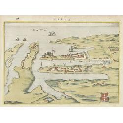
Malta.
Attractive birds-eye town-view of Valetta on Malta. With coat of arms lower right. With page number 398 in top. Latin text on verso.From "Nova et accurate Italiae ho...
Date: Amsterdam, 1626
![[Title page] Libellus Novus Politicus.. Pars Quarta.](/uploads/cache/38482-250x250.jpg)
[Title page] Libellus Novus Politicus.. Pars Quarta.
Very skillfully engraved title page from a rare work printed by Eberhard Kieser: Thesaurus Philo-Politicus. Das ist Politisches Schatzkästlein guter Herren und bestendig...
- $80 / ≈ €68
Date: Frankfurt, 1626
![[Title page] Libellus Novus Politicus.. Pars Tertia.](/uploads/cache/38481-250x250.jpg)
[Title page] Libellus Novus Politicus.. Pars Tertia.
Very skillfully engraved title page from a rare work printed by Eberhard Kieser: Thesaurus Philo-Politicus. Das ist Politisches Schatzkästlein guter Herren und bestendig...
- $80 / ≈ €68
Date: Frankfurt, 1626
![[Title page] Libellus Novus Politicus.. Pars Altra.](/uploads/cache/38480-250x250.jpg)
[Title page] Libellus Novus Politicus.. Pars Altra.
Very skillfully engraved title page from a rare work printed by Eberhard Kieser: Thesaurus Philo-Politicus. Das ist Politisches Schatzkästlein guter Herren und bestendig...
- $80 / ≈ €68
Date: Frankfurt, 1626
![[Title page] Libellus Novus Politicus.. Pars Octava.](/uploads/cache/38471-250x250.jpg)
[Title page] Libellus Novus Politicus.. Pars Octava.
Very skillfully engraved title page from a rare work printed by Eberhard Kieser: Thesaurus Philo-Politicus. Das ist Politisches Schatzkästlein guter Herren und bestendig...
- $75 / ≈ €64
Date: Frankfurt, 1626
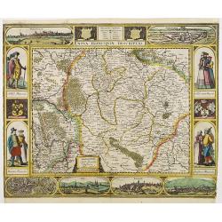
Nova Franconiae Descriptio.
In 1626 Abraham Goos engraved a single-sheet "carte à figures"- map of Franconia with decorative borders for Joannes Janssonius. In the center part of the top ...
- $2000 / ≈ €1709
Date: Amsterdam, 1626
![[Title page] Libellus Novus Politicus.. Pars Tertia.](/uploads/cache/38476-250x250.jpg)
[Title page] Libellus Novus Politicus.. Pars Tertia.
Very skilfully engraved title page from a rare work printed by Eberhard Kieser: Thesaurus Philo-Politicus. Das ist Politisches Schatzkästlein guter Herren und bestendige...
- $90 / ≈ €77
Date: Frankfurt, 1626
Nova totius Westphalia descriptio / ex celeberrimis et variis autoribus in unam tabulam redacta per Nicolaum Janssonium Visscher aut . . .
Shows the area between Maastricht, Dockum, Herschfelt and Hamburg. A fine copy in attractive original colors and dated in the plate, 1626.
- $200 / ≈ €171
Date: Amsterdam, 1626

A new mape of Ye XVII Provinces of Low Germanie.
Showing all 17 Provinces of the Netherlands before the split between Spain and the Protestant Provinces under the House of Orange. The map was published while the war of ...
Date: London, George Humble, 1626 [1627
A Newe mape of Poland Done into English by I.Speede.
A wonderful map of Poland. Incorporated into Speed's 'Prospect Of The Most Famous Parts Of The World'. Includes birds-eye views of Cracow, Dantzick, Posna, Crossen, Sando...
Date: London, 1627
Carte de L'Europe, corrigée et augmentée desus toutes les autres . . .
Rare map of Europe, dated 1627. First state, issued by Melchior Tavernier. Most probably engraved by Cornelis Danckerts (the elder), a highly skilled engraver. Most proba...
Date: Paris, 1627
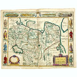
A newe mape of Tartary.
Early edition of one of the most decorative maps of Tartary, known for its figured borders with costume figures, while above are vignettes of the cities of Astrakhan, Sam...
- $2500 / ≈ €2136
Date: London, 1627

The Kingdome of China.
A most sought-after map of China. Decorative border vignettes including views of the cities of Quinzay and Macao along the top border with the wheeled wind machines and p...
Date: London, G. Humble, 1627
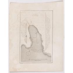
Victoria Harbour.
Chart of Victoria Harbour, showing where stores unloaded, depth readings. Plate from John Ross's Second Voyage in Search of a Northwest Passage, from the book entitled 'N...
Date: London, 1627

A Newe mape of Poland Done into English by I.Speede.
A wonderful map of Poland. Incorporated into Speed's 'Prospect Of The Most Famous Parts Of The World.' Includes birds-eye views of Cracow, Dantzick, Posna, Crossen, Sando...
Date: London, 1627

Carte de la Coste de La Rochelle a Brouaige et de l'Isle d'Oleron Observee par le S.r de Chattillon ingenieur du Roy.
Map of the island of Oléron, with an inset in lower left corner showing the route of an English fleet to La Rochelle. At the time of mapping the area was a stronghold of...
Date: Paris, 1627
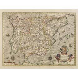
Hispaniae nova describtio. . .
Map of Spain and Portugal. Engraved by Petrus Kaerius.
- $750 / ≈ €641
Date: Amsterdam, 1628
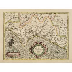
Regni Valentiae Typus.
Fine early map of Valencia.
- $500 / ≈ €427
Date: Amsterdam, 1628
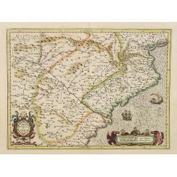
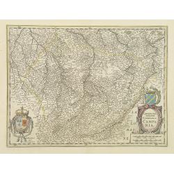
Arragonia et Catalonia
Aragon and Catalonia. Decorative map with mountain relief and river. 2 finely engraved sailing boats.Mercator was born in Rupelmonde in Flanders and studied in Louvain un...
- $600 / ≈ €513
Date: Amsterdam, 1628

Kaerte van Bergen op Zoom, Steenbergen ende de nieuwe fortificatien gemaeckt tot bevrÿdinge van 't landt van ter Tolen in tjaar 1628.
Very detailed and scarce map showing Bergen Op Zoom, Steenbergen and its surrounding countryside. North to the left side.
Date: Amsterdam, after 1628
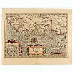
Guineae Nova Descriptio.
The map shows the West African coast from Senegal (the 'Rio Senega' is the Senegal River) to Cape Lopez on the Gulf of Guinea just below the equator.The island of St. Tho...
- $700 / ≈ €598
Date: Amsterdam, 1628
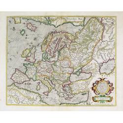
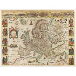
Europa, ad magnae Europae Gerardi Mercatoris. . .
General map of Europe with in the left hand corner, south east of Iceland the mythical island of Frisland, which was purportedly discovered by the Zeno brothers in a 14th...
Date: Amsterdam, 1628

Europa, ad magnae Europae Gerardi Mercatoris. . .
General map of Europe, as well as Americae Pars, Greenland, Iceland, a Polar landmass, along with the mythical islands of Frisland, Drogeo, and Bradain. A large strapwor...
Date: Amsterdam, 1628
Arragonia et Catalonia.
Aragon and Catalonia. Decorative map with mountain relief and river. 2 finely engraved sailing boats.Mercator was born in Rupelmonde in Flanders and studied in Louvain un...
- $250 / ≈ €214
Date: Amsterdam, 1628
Set of four continents.
Fine set of 4 continents prepared by Gerard Mercator. The general map of Europe, as well as Americae Pars, Greenland, Iceland, a Polar landmass, along with the mythical i...
Date: Amsterdam, 1628
Taurica Chersonesus.
One of the earliest detailed maps of the Crimea and Ukraine between the northern coast of the Black Sea and Moscow.With the signature of Gerard Mercator in lower left cor...
Date: Amsterdam, 1628
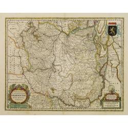
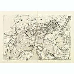
Novissima et Accuratissima Brabantiae Ducatus Tabula.
North is to the right. Like all other maps of Brabantiae Ducatus, it encloses the area between the rivers Rhine, Maas and Schelde, with Namur as the most southern town. O...
- $350 / ≈ €299
Date: Amsterdam, 1629
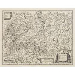
Sueviae Nova Tabula.
Extremely rare first edition of this beautiful map of Swaben, including Ulm, Augsburg, Stuttgart, Zurich, Lucerne and Lake Constance.Jodocus Hondius Jr. planned to produc...
Date: Amsterdam, 1629
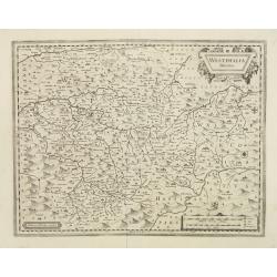
Westphalia Ducatus.
Extremely rare first edition of this beautiful map of Westphalia.Jodocus Hondius Jr. planned to produce a new modern atlas less dependent on the Mercator plates that his ...
Date: Amsterdam, 1629
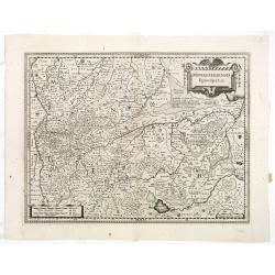
Monasteriensis Episcopatus.
The extremely rare first edition of this beautiful map of Munster.Jodocus Hondius Jr. planned to produce a new modern atlas less dependent on the Mercator plates that his...
Date: Amsterdam, 1629

Coloniensis Archiepisscopatus.
Extremely rare first edition of this beautiful map of Cologne and Dusseldorff.Jodocus Hondius Jr. planned to produce a new modern atlas less dependent on the Mercator pla...
Date: Amsterdam, 1629
![Figure 27 deuxieme partie a gauche.. [Hors riding].](/uploads/cache/14160-250x250.jpg)
Figure 27 deuxieme partie a gauche.. [Hors riding].
This fabulous illustration depicts formal movements of equitation for horse riding school movements. The print shows both A.de Pluvinel and the future King at the age of ...
Date: Paris, 1629
![Figure 38 troisieme partie. [Hors riding]](/uploads/cache/14164-250x250.jpg)
Figure 38 troisieme partie. [Hors riding]
This fabulous illustration depicts formal movements of equitation for horse riding school movements. The print shows both A.de Pluvinel and the future King at the age of ...
Date: Paris, 1629
![Figure 40 deuxieme partie. [Hors riding]](/uploads/cache/14165-250x250.jpg)
Figure 40 deuxieme partie. [Hors riding]
This fabulous illustration depict formal movements of equitation for horse riding school movements. The print shows both A.de Pluvinel and the future King at an age of 16...
- $250 / ≈ €214
Date: Paris 1629

Daniae Regni Typum..
A first state. Very decorative "carte à figures"- map of Denmark with the signature of the engraver Abraham Goos. Printed on heavy paper, in spite of its repai...
Date: Amsterdam, 1629
Alpinae seu Foederatae Rhaetiae . . .
Extremely rare first edition of this beautiful map of Graubünden Canton in Switzerland. Including Chur, Davos, St.Moritz, etc.Jodocus Hondius Jr. planned to produce a ne...
- $750 / ≈ €641
Date: Amsterdam, 1629

Valletta citta nova dimalta.
Early copper engraved map of the towns of Valletta, Borgo, Sanglea di Sto. Michele, and the church of St. Salvator -known as the Three Cities., engraved by Henry Raignaul...
Date: Paris, Michael Soly, 1629

Turcici Imperii Imago.
The map shows the Ottoman Empire with Turkey, Black Sea, Mediterranean Sea, Arabia and North Eastern Africa. The map is decorated with a title cartouche and a portrait of...
Date: Amsterdam, 1629
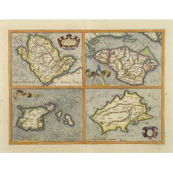
Anglesey. / Iarsay. / Carnesay. / Wight Vectis Olim.
Four maps on one sheet depicting the English islands Jersey, Guernsey, Wright and Alderney.
Date: Amsterdam, 1629
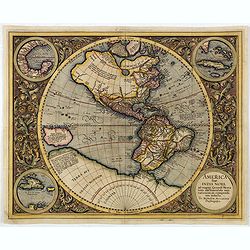
America sive India Nova.
This map was created by Michael Mercator, grandson of the great Gerard Mercator. It is the only map attributed to him. The map first appeared in 1595, one year after the ...
- $3000 / ≈ €2563
Date: Amsterdam, 1630
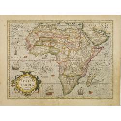
Nova Africae Tabula.
An attractive map of the continent, added by Hondius when he took over publication of Mercator's Atlas. Although it is based on Mercator's map, Hondius improved the outli...
Date: Amsterdam, 1630
Westphalia Ducatus.
Elegantly engraved map of Westphalia including Hamm and Lippstadt. The mountainous topography is graphically depicted and several small coats of arms dot the map. Strapwo...
Date: Amsterdam, 1629-1630
Pas-Caert vande ghelegetheyt vande Schans te Santvliet, Vertoonede de verdroncken overwaeterde Landen, nieuw aengewasse gorsingen,. . .
Showing the surrounding countryside of the cities of Antwerp, Santvliet, Lillo, Bergen op zoom, etc. The map is ponctuated by several fortifications to indicate the main ...
Date: Amsterdam, 1630
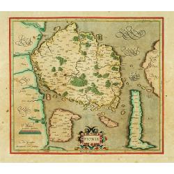
Fionia.
Early map, including Odense and the island Langeland .
- $200 / ≈ €171
Date: Amsterdam 1630
Champagne Comitatus Campania.
Map of French region of Champagne, including part of Lorraine. North to the east. The second state with the signature of J.Janssonius.
- $220 / ≈ €188
Date: Amsterdam, 1630
Nova Europae descriptio.
Rare early issue of the map of Europe with the lower border removed and without text on the reverse. Variant : The map has no longer the lower border, doesn't have text o...
Date: Amsterdam, after 1630
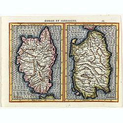
Corsse et Sardaigne.
Maps of Corsica and Sardinia from the rare Cloppenburg edition slightly larger format and more scarce edition of the Mercator/Hondius "Atlas Minor". Engraved by...
- $300 / ≈ €256
Date: Amsterdam, 1630
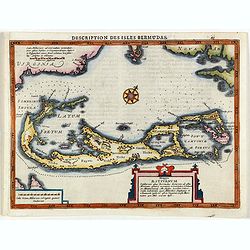
Description des Isles Bermudas.
Map of Bermuda from the rare Cloppenburg edition slightly larger format and more scarce edition of the Mercator/Hondius "Atlas Minor". Engraved by Pieter Van De...
- $800 / ≈ €684
Date: Amsterdam, 1630
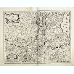
Ducatus Geldriae novissima. . .
Early map of Gelderland, but also including Utrecht, and parts of Brabant. Shows many cities (like Nijmegen, Eindhoven, Zutphen, Zwolle, etc), roads, rivers, woods, regio...
Date: Amsterdam, 1629-1630
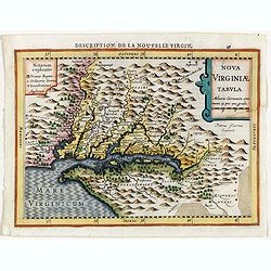
Virginiae item et Floridae . . .
Map of Virginia from the rare Cloppenburg edition slightly larger format and more scarce edition of the Mercator/Hondius "Atlas Minor". Engraved by Pieter Van D...
- $750 / ≈ €641
Date: Amsterdam, 1630
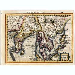
India Orientalis.
Map covering India, Thailand, Philippines, Northern Borneo and the coast of Southern China. From the rare Cloppenburg edition "Atlas Sive Cosmographicae Meditationes...
- $550 / ≈ €470
Date: Amsterdam, 1630

Candia cum Insulis.. Corfu Zante, Milo, Nicsia, Santorini.
Four views on one sheet: A large map of Crete, with three smaller views across the top showing the Ionian Islands of Kerkira (Corfu), Cephalonia and Zakinthos (Zante.) Th...
Date: Amsterdam, 1630
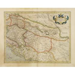
Sclavonia, Croatia, Bosnia cum Dalmatiae parte.
Nice map of the Eastern Balkans with the political divisions of Slovenia, Croatia, Bosnia and Dalmatia.Mercator was born in Rupelmonde in Flanders and studied in Louvain ...
- $300 / ≈ €256
Date: Amsterdam 1630
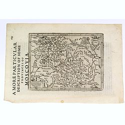
A More Particular Description of some Provinces of Moscovia.
From the English edition of the popular Mercator - Hondius atlas. English text to verso. This map elegantly depicts the Muscovy region of western Russia, with Moscow in t...
- $225 / ≈ €192
Date: Amsterdam, 1630
![[Title page] Thesauri Philo Polithi Tertia pars..](/uploads/cache/38445-250x250.jpg)
[Title page] Thesauri Philo Polithi Tertia pars..
Very skilfully engraved title page from a rare work printed by Eberhard Kieser: "Thesaurus Philo-Politicus. Das ist Politisches Schatzkästlein guter Herren und best...
- $80 / ≈ €68
Date: Frankfurt, 1630
![[Title page] Thesauri Philo-Politci Pars Sexta. . .](/uploads/cache/38446-250x250.jpg)
[Title page] Thesauri Philo-Politci Pars Sexta. . .
Very skilfully engraved title page from a rare work printed by Eberhard Kieser: Thesaurus Philo-Politicus. Das ist Politisches Schatzkästlein guter Herren und bestendige...
Date: Frankfurt, 1630
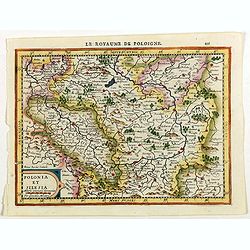
Polonia et Silesia.
Map of Poland and Silesia from the rare Cloppenburg edition slightly larger format and more scarce edition of the Mercator/Hondius "Atlas Minor". Engraved by Pi...
Date: Amsterdam, 1630
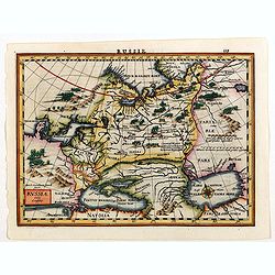
Russia.
Russia map from the rare Cloppenburg edition slightly larger format and more scarce edition of the Mercator/Hondius "Atlas Minor". Engraved by Pieter Van Den Ke...
Date: Amsterdam, 1630
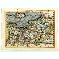
Prussia.
An attractive, detailed and early map of present-day Poland and Lithuania from the rare Cloppenburg edition slightly larger format and more scarce edition of the Mercator...
Date: Amsterdam, 1630
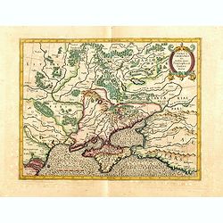
![Tabula electoratus Brandenburgici, Meckelenburgi, et maximae partis Pomeraniae, ex variis, famosissimisq[ue] auctoribus summo studio concinnata. . .](/uploads/cache/29543-250x250.jpg)
Tabula electoratus Brandenburgici, Meckelenburgi, et maximae partis Pomeraniae, ex variis, famosissimisq[ue] auctoribus summo studio concinnata. . .
Uncommon "carte à figures"- map engraved by the master engraver Abraham Goos and published by Claes Jansz. Visscher (1587-1652). Showing the area of Brandenbur...
Date: Amsterdam, 1630
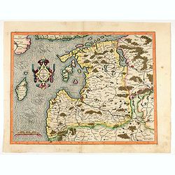
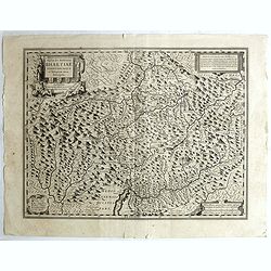
Livonia. 1627
Detailed map of the northern Baltic region. The map is centered on Riga and extends south to Memel, west to Poland and part of Russia and north to the Strait between Finl...
Date: Amsterdam, ca. 1630

