Browse Listings in Europe
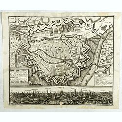
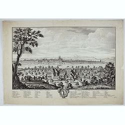
Dantiscum F. Gedanum celeberrimum . . .
Dantzig city plan with a bird-eye view of the city and the main monuments.Matthaus Seutter the elder first published his "Atlas Geographicus" in 1720 and added ...
Date: Augsburg, ca. 1740
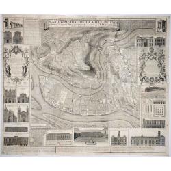
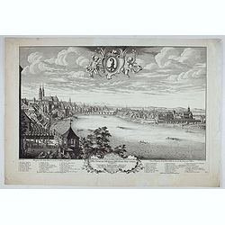
Plan Geometral de la Ville de Lyon.
A gigantic wall map of Lyon was originally issued in 1735 and revised in 1740. Engraved by Claude Seracourt and published by R.P. Grégoire in Lyon, France in 1740.This i...
Date: Lyon, ca. 1740

Carte particulière des environs de St Peters-bourg. . . / Plan de la ville faubourg et environs de St Petersbourg. . . / Carte pour l'intelligence de la guerre de Moscovie et de Suede. . .
A scarce and unusual plan of Saint Petersburg shown at a large scale and also, in a separate compartment, shown in its geographical context between the Gulf of Finland an...
Date: Paris, c.1741
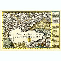
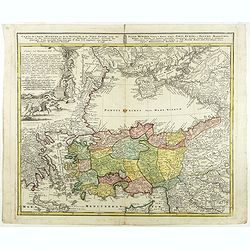
Die Europaeische oder kleine Tartarey, nebst den angraentzenden Laendern. . .
Showing the Black Sea region. Uncommon map from the "Atlas Selectus" by the German cartographer Johann Georg Schreiber (1676-1750). Schreiber followed in the fo...
- $450 / ≈ €381
Date: Leipzig, 1741
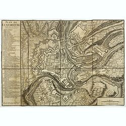
Plan de Luxembourg.
Beautiful engraved plan of the city of Luxembourg, accompanied by a table of references.
- $500 / ≈ €424
Date: Paris, 1741
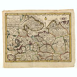
'T Noorderdeel van Moscovie Na de stelling van G. de L'Isle. . .
Attractive and rare map of part of Russia, including St. Persburg, Archangel, Finland, Lapland and Moscow. From Atlas Portatif .
- $100 / ≈ €85
Date: Deventer, 1742
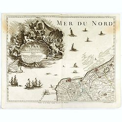
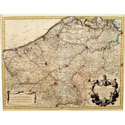
Carte des Pais Bas contenant la Flandre, le Brabant, Pais de Liege. . .
Map sheet from a multi-sheet map of the Low Countries, showing a large title cartouche and part of the Northern French coast line around Calais, Duinkerken and Furnes. Th...
- $75 / ≈ €64
Date: Paris, 1742
Rom: Keyserl. Majest. Königl Hoher Allierten Kriegs Theatrum von Schlesien, Böhmen, Maehren u: Oestereich. . .
A rare map centred on Austria, eastern Germany, Poland and Tsjechië. In upper right corner an inset plan of Prague. Showing the situation of the first Silesian War of 17...
- $900 / ≈ €762
Date: Nuremberg, 1742
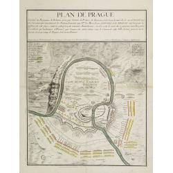
Plan de Prague.
Rare and separately published plan of Prague published by Joan Baptista Nolin with the address à l'enseigne de la Place des Victoires et chez le Sr. Humblot rue St. Jacq...
- $550 / ≈ €466
Date: Paris, ca. 1742

Imperii Russici et Tartariae Universae tabula novissima.
Decorative and rare map covering Russia, Tibet, China, Tartary, Korea, Taiwan and Japan prepared by J. M. Hasius. The sea between Japan and Korea is mentioned Mare Orient...
Date: Utrecht, 1743

ANNA IWANOVNA - Anna Ioannovna imperatricea i camoderschiza wserossinskaja (rossice). Anna Joannowna imperatrix totius Russiae
Extremely rare half portrait print of Anna Ivanovna (7 February [O.S. 28 January] 1693, Moscow – 28 October [O.S. 17 October] 1740) reigned as Duchess of Courland from ...
Date: St. Petersburg, 1743

ELISABETH I. - Elisabet imperatriza wseros sinskaja petra welikago dscherj (rossice). Elisabetha imperatrix. Omnium Russiarum Petri. Magni. Filia.
Extremely rare half portrait print of Elizaveta Petrovna (29 December [O.S. 18 December] 1709 – 5 January 1762 [O.S. 25 December 1761] ), also known as Yelisavet and El...
Date: St. Petersburg, 1743

FJODOR JOANNOWITSCH - Feodor Ioannowitsch zar i camoderschez wserossinskij (rossice). Feodor Ioannowicz tzaar et autocrator totius Russiae Joann Alexiewicz tzaar et autocrator totius Russiae.
Extremely rare half portrait print of Czar Fyodor I Ivanovich (31 May 1557 – 16/17 January 1598) was the last Rurikid Tsar of Russia (1584 - 1598), son of Ivan the Terr...
Date: St. Petersburg 1743

ALEXEI I. - Alexei Michailowitsch zar i camoderschez wserossinskij (rossice). Alexei Michailowicz tzaar et autocrator totius Russiae.
Extremely rare half portrait print of Czar Alexei Michailowicz..Aleksey Mikhailovich Romanov ( 9 March 1629 (O.S.) – 29 January 1676 was the Tsar of Russia during some ...
Date: St. Petersburg, 1743

IWAN ALEXEJEWITSCH - Ioann Alexejewitsch zar i camoderschez wserossinskij (rossice).Joann Alexiewicz tzaar et autocrator totius Russiae.
Extremely rare print of Czar Ivan Alexejewitsch, who was the brother of Peter the Great.Johann Stenglin was a well known engraver, born at Augsburg in 1715, he studied un...
Date: St. Petersburg 1743
Carte de l'Asie Minevre ou de la Natolie et du Pont Euxin...
A map centered on the Black Sea and the geographical regions surrounding it. The map shows Asia Minor, Crete, Cyprus, northern Syria, Iraq, Georgia, Crimea, Bulgaria, Rom...
Date: Nuremberg, 1743
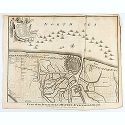
Plan of the Investiture of Ostend Surrenderd, 6 July, 1706
An interesting copper engraved plan of the Fortification of Doway in Flanders, with an attractive rococo cartouche, showing an overview of the battlefield and surrounding...
Date: London, 1743
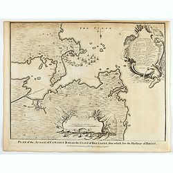
Plan of the Attack of Camaret Bay, on the coast of Bretagne, thro which lies the Harbour of Brest.
An interesting copper engraved plan of the Fortification of Camaret in Bretagne (France), with an attractive rococo cartouche, showing an overview of the battlefield and ...
Date: London, 1743
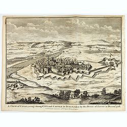
A view of Cassel, a very strong city in Italy, taken by the Duke of Savoy in Decem.r 1706
An interesting copper engraved plan of the Fortification of Cassel in Italy, with an attractive rococo cartouche, showing an overview of the battlefield and surrounding a...
Date: London, 1743
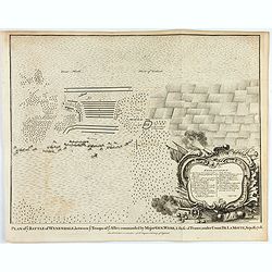
Plan of ye Battle of Wynendale between ye Troops of ye Allies commanded by Major Gen. Webb & those of France under Count de La Motte Sept. 28 1708.
An interesting copper engraved battle plan of Pinedale during the War of the Spanish Succession, showing the position of General Webb's troops in order to protect an alli...
Date: London, 1743
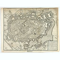
Mons the Capital City of Hainault in y Low Countries, taken by y French in 1691, Restor'd to y Spaniards by y Peace of Ryswick in 1697, retaken by y Allies in 1709, and left to y Emperor by y Treaty of Utrecht. .
An interesting copper engraved view of the walled city engraved by I. Basire, with pictographs of buildings. Many buildings and places are named on the map. Nicholas Tind...
Date: London, 1743
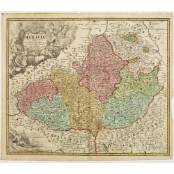
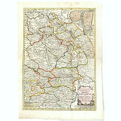
Tabula Generalis Marchionatus Moraviae..
Johann Baptist Homann's well-engraved map has a large decorative cartouche. Detailed map of the historic Moravia region of the Czech Republic, in the present-day Jihormor...
- $275 / ≈ €233
Date: Nuremberg 1744
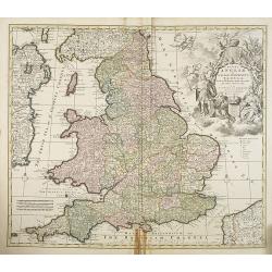
Regni Angliae et Wallae principatus Tabula, divisa in LII Regiones. . .
A detailed and decorative map of England, with an attractive uncolored title cartouche. The map is a re-issue of Carolus Allard's map. The elaborate title cartouche in th...
- $400 / ≈ €339
Date: Amsterdam c. 1744
![[2 maps and one text sheet] Theatrum Belli A° MDCCXXXVII. . . / Verus Chersonesi Tauricae Seu Crimea Conspectus adjacentium item Regionem itinerisq ab Exercitu Ruthemo...](/uploads/cache/27975-250x250.jpg)
[2 maps and one text sheet] Theatrum Belli A° MDCCXXXVII. . . / Verus Chersonesi Tauricae Seu Crimea Conspectus adjacentium item Regionem itinerisq ab Exercitu Ruthemo...
[2 maps and one text sheet] Theatrum Belli A° MDCCXXXVII. . . / Verus Chersonesi Tauricae Seu Crimea Conspectus adjacentium item Regionem itinerisq ab Exercitu Ruthemo A...
- $1100 / ≈ €932
Date: Amsterdam, c. 1744
Cours du Danube, Feuille 1 contenant LA SUABE . . .
Fine map of part of the River Danube, including the southern German province of Swaben.From his rare atlas "Theatre de la Guerre en Allemagne, contenant toutes les O...
Date: Paris, 1744
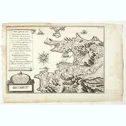
Hic Jacent Puteolorum Bajarum, Miseni Cumarium. . .
A bird's-eye view of Puzzoli and environs, depicting fascinating topographical and architectural features of interest. Title cartouche describes the map and area in Latin...
- $80 / ≈ €68
Date: London, 1725-1744
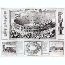
Anfiteatro detto l'Arena di Verona.
Large two sheet copper engraving of the Amphitheater of Verona after a design of Adriano Cristofali. On three sides it is surrounded by architectural details interspersed...
- $2200 / ≈ €1863
Date: Verona, 1744

Chaerte vande Wieringer waert, de welcke inden jaere XVI… (Wieringerwaard)
Rare wall map of the Wieringerwaard polder, as raffled on 12 July 1611. The polder was laid dry in 1610. It border, and the municipality's border, were the Zuiderzee, the...
Date: 1741-1744
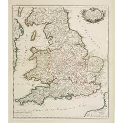
Le royaume d'Angleterre..
Fine map of England and Wales. As well as country details, including the main post roads. Le Rouge was active from 1740- till 1780 as a publisher, and was appointed engin...
- $250 / ≈ €212
Date: Paris, 1745
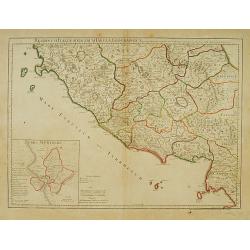
Regionum Italiae mediarum Tabula Geographica. . .
Fine historical map of central Italy with Tuscany, centered on Rome, in the south Pompeii, in the top the island of Giglio and the town Orbetello. Lower left inset plan o...
- $150 / ≈ €127
Date: Paris, 1745
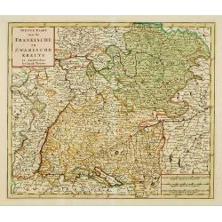
Nieuwe Kaart van de Frankische en Zwabische Kreits.
Deatailed map of the Southern part of Germany. Isaak Tirion was born in Utrecht ca. 1705. He came to Amsterdam ca. 1725. Tirion published a number of important books, m...
- $100 / ≈ €85
Date: Amsterdam, 1745

Nieuwe Kaart van de Westfaalse Kreits..
Isaac Tirion was born in Utrecht ca. 1705. He came to Amsterdam ca. 1725. Tirion published a number of important books, many of which are still in demand for their intere...
Date: Amsterdam, 1745
![Partie Septentrionale de la Souabe [and] Partie Meridionale de la Souabe. (2 maps)](/uploads/cache/21468-250x250.jpg)
Partie Septentrionale de la Souabe [and] Partie Meridionale de la Souabe. (2 maps)
Pair of maps forms a large, detailed view of Swabia, one of the ten circles of the Holy Roman Empire and containing some of the historically most interesting and cultural...
- $250 / ≈ €212
Date: Amsterdam c. 1745
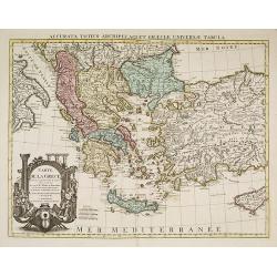
Carte de la Grece dressée sur un grand nombre de memoires. . .
Detailed copper-engraved map of Greece with its neighboring countries, including southern Italy and part of Cyprus. Relief shown pictorially. With large decorative title ...
Date: Amsterdam c. 1745
Carte Des Pays Bas Catholiques Dressée. . .
Topographically detailed map that extends from Paris to Metz and north into Holland. Details include roads and scores of villages. Two decorative cartouches: one with fig...
Date: Amsterdam, c. 1745
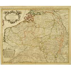
Carte du Comté de Flandre, Dressée sur differens. . .
Large, detailed map of the Flanders including the French Flemish-speaking area. Shows illustrated topography with notations about towns, roads, fortresses, abbeys, monast...
Date: Amsterdam, c. 1745
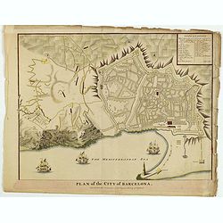
Plan of the City of Barcelona.
From Rapin's History of England , a nicely detailed plan of Barcelona, the capital of Catalonia. The plate contains a 19 point legend and the presentation is enhanced wit...
Date: London, c.1745
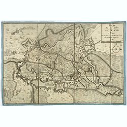
Plan de la ville de Gand. Paris, Sr. Le Rouge, 1745.
Town-plan of Ghent with its citadel, published in 1745, the year when the city was taken by the French during the War of Austrian Succession. The north is located to the ...
- $380 / ≈ €322
Date: Paris, 1745
![ATLAS RUSSICUS mappa una generali et undeviginti specialibus vastissimum Imperium Russicum cum adiacentibus regionibus [repeated in French].](/uploads/cache/27877-250x250.jpg)
ATLAS RUSSICUS mappa una generali et undeviginti specialibus vastissimum Imperium Russicum cum adiacentibus regionibus [repeated in French].
After an unnumbered general map of Russia there are 13 numbered maps that cover European Russia (scale 1, 1.527.000). The other (last) 6 maps cover Asian Russia (Siberia,...
Date: St Peterburg, Akademie von Wissenschaften. 1745
![[Lot of 3 maps] Carte de la Souveraineté de NEUCHATEL et VALLANGIN. Plus Mercator's and Blaeu's maps of the Wiflispurgergou]](/uploads/cache/18600-250x250.jpg)
[Lot of 3 maps] Carte de la Souveraineté de NEUCHATEL et VALLANGIN. Plus Mercator's and Blaeu's maps of the Wiflispurgergou]
Map of the lake of Neuchatel by Covens & Mortier. After the death of the widow of Pieter Mortier in 1719, the firm continued till 1778 as Covens & Mortier. They...
- $350 / ≈ €296
Date: Amsterdam, c. 1745
Prospect der Statt Basel von Seiten der Kleinen Statt - Vüe et Perspective de la Ville de Bâle du côté de la petite Ville.
Very decorative view of Basle, after a design by Emanuel Büchel and engraved by Johann Martin Weiss. The legend inscribed under the engraving, numbered from 1 to 10, des...
Date: Basle, 1745
Prospect der Statt Basel von Seiten der Schlösser - Vuë et Perspective de la Ville de Bale du coté des Chateaux de Gundeldingue.
Very decorative view looking towards Basel from the castle at Gundeldingen, on a hill to the south. Accompanied at the bottom by a cartouche containing the arms of the ci...
Date: Basle, ca. 1745
Prospect der Statt Basel von der St Alban Vorstraat - Vu¨e et perspective de la ville de Bâle du côté du Faubourg de St Albon.
Very decorative view of Basel, after a design by Emanuel Büchel and engraved by Johann Martin Weiss. Numbered 'No.1' in the bottom right, from a rare series of 4 sheets.
Date: Basle, ca. 1745
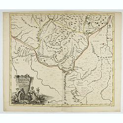
Uffensis Provincia Cum adiacentibus Regionibus.
Volga-Ural Region. From the first regional atlas of Russia, published by the Academy of Sciences in St. Petersburg, expanding on the cartographic work done previously by ...
Date: Academy of Sciences, St. Petersburg, 1745
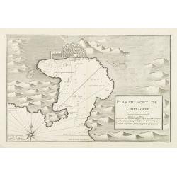
Plan du Port de Cartagene.
Sea chart of the Port of Cartagene. Marked with navigational notes.From the rare chart book by Jacques Ayrouard: Recueil de plusieurs Ports de la Mer Méditerranée...
- $200 / ≈ €169
Date: Marseille, 1732-1746

Itinera Varia Auctoris.
From A Natural History of Uncommon Birds, and of some other rare and undescribed Animals, Quadrupeds, Reptiles, fishes, insects, &c.. The map shows Edwards' journeys ...
- $300 / ≈ €254
Date: London, 1746

Plan du Golfe et des Caps de St. Tropez. par Jacques Ayrouard . . .
Large plan of the harbour St. Tropez. Decorated with a large compass rose.From the rare chart book by Jacques Ayrouard: "Recueil de plusieurs plans des ports et rade...
Date: Marseille, 1732-1746
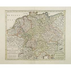
Nieuwe Kaart van Duitsland..
Detailed map of Germany, including The Netherlands, Belgium, Luxembourg, Switzerland and Austria. Isaac Tirion was born in Utrecht ca. 1705. He came to Amsterdam ca. 1725...
- $120 / ≈ €102
Date: Amsterdam, 1747
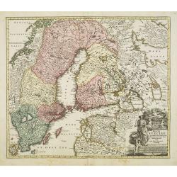
Regni Sueciae. . .
Johann Baptist Homann's well-engraved map has a large decorative cartouche. Detailed map of Sweden and Finland.Johann Baptist Homann (1663-1724) was a German engraver and...
Date: Nuremberg, 1747
Regni Sueciae in omnes suas Subjacentes Provincias accurate divisi Tabula Generalis. . .
Johann Baptist Homann's well-engraved map has a large decorative cartouche. Detailed map of Scandinavia, the Baltic Sea, Lithuania, Latvia, Estonia, Curlandia, etc.Johann...
Date: Nuremberg, 1747

Kaart van Zeeland.
Fine map of the province of Zeeland, with the fortified cities are highlighted in red. Isaac Tirion was born in Utrecht ca. 1705. He came to Amsterdam ca. 1725. Tirion pu...
Date: Amsterdam, 1747
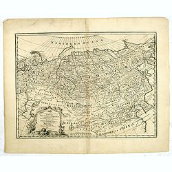
A New and Accurate Map of the Whole Russian Empire as contained both in Europe and Asia. . .
Detailed map of Russia, from the Sea of Anadyr, Sea of Kamchatka and the Kuril Islands to St.Petersburg. Also includes Tibet, Korea and part of China, with the Great Wall...
- $200 / ≈ €169
Date: London, c. 1747
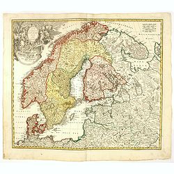
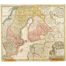
Scandinavia complectens Sueciae, Daniae & Norvegia. . .
Johann Baptist Homann's well-engraved map has a large decorative cartouche. Detailed map of Scandinavia.Johann Baptist Homann (1663-1724) was a German engraver and publis...
- $350 / ≈ €296
Date: Nuremberg, 1747
A Map of the Rout which Hannibal took through Gaul & over the Alpes into Italy.
A map showing the (clear) route the North African, Carthaginian General Hannibal took to get from Spain to northern Italy, via France and the Alps. Ancient, Latin names a...
- $40 / ≈ €34
Date: London, 1747
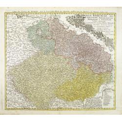
Regni Bohemiae, Duc. Silesiae, Marchionatuum Moraviae et Lusatiae. . .
Johann Baptist Homann's well-engraved map including the towns of Prague, Poznan/ Loda, Wroclaw, etc.This example was printed from plate A (1st of 3), which can be identif...
- $200 / ≈ €169
Date: Nuremberg, ca. 1748
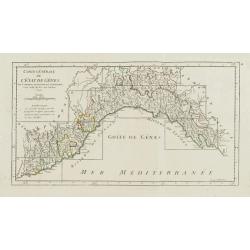
Carte Générale de l'Etat de Gênes.
Detailed map centered on the Gulf of Genoa. It shows the Italian region Liguria and extends westwards as far as Nice.Key map for the nine large-scale maps de Vaugondy mad...
- $100 / ≈ €85
Date: Paris, ca. 1748

III. Carte de la Hollande.. Over-Yssel.
Attractive small map centered on the delta of the River Ijssel, where it discharges into the Zuiderzee.From Atlas Portatif Universel, by Robert de Vaugondy. Unrecorded st...
Date: Paris, later than 1748

VI. Partie du Duche de Gueldre où se trouve la Veluwe.
Attractive small map covering the northwestern part of Gelderland. In the center "'t Loo". From Atlas Portatif Universel, by Robert de Vaugondy.Unrecorded state...
Date: Paris, later than 1748
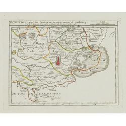
VI. Carte du Duché de Limbourg où sont les environs de Limbourg.
Attractive small map showing part of the Wallon region, centered on Limburg. Dated 1748. From Atlas Portatif Universel, by Robert de Vaugondy.Page 15f outside border top ...
- $45 / ≈ €38
Date: Paris, 1748
V. Carte du Brabant ou se trouvét les Mair.s d'Herentals.. Hochstraten.
Nice small map illustrating the northeastern part of the Flemish region. Centered on Turnhout.From Atlas Portatif Universel, by Robert de Vaugondy. Unrecorded state with ...
- $50 / ≈ €42
Date: Paris, later than 1748
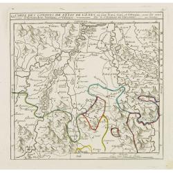
VI. Carte des Confins de l'Etat de Gênes où sont Novi, Gavi, et Ottagio..
Detailed small map encompassing the part of Piedmont between Alessandria, Tortona and Novi Ligure.Relief shown pictorially. From Atlas Portatif Universel, by Robert de Va...
- $150 / ≈ €127
Date: Paris, later than 1748
![VIII. Carte de l'Etat de Genes [. . .] Toscane.](/uploads/cache/24551-250x250.jpg)
VIII. Carte de l'Etat de Genes [. . .] Toscane.
Detailed small map showing an area straddling the provinces of Genoa, La Spezia, Parma and Massa Carrara, Tuscany.Relief shown pictorially. From Atlas Portatif Universel,...
Date: Paris, later than 1748
![[X.] Carte du Brabant où sont les environs de Tillemont, de Judoigne, de Gemblours &c.](/uploads/cache/24690-250x250.jpg)
[X.] Carte du Brabant où sont les environs de Tillemont, de Judoigne, de Gemblours &c.
Nice small map straddling the Flemish and the Walloon regions. Extending North to South from Tienen to Gembloux.From Atlas Portatif Universel, by Robert de Vaugondy. Unre...
- $30 / ≈ €25
Date: Paris, later than 1748
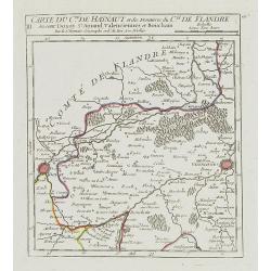
III. Carte du C.té de Haynaut et des Frontieres du C.té de Flandre..
Attractive small map encompassing part of the Nord, between Douai and Valenciennes.From Atlas Portatif Universel, by Robert de Vaugondy.Unrecorded state with erased date....
Date: Paris, after 1748
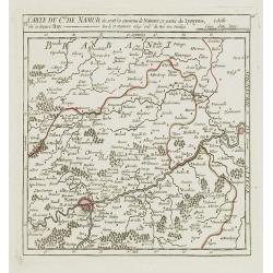
VI. Carte du C.té de Namur où sont les environs de Namur.. Huy.
Attractive small map illustrating part of the Walloon Region, between Namur and Huy. From Atlas Portatif Universel, by Robert de Vaugondy.Unrecorded state with erased dat...
- $50 / ≈ €42
Date: Paris, after 1748
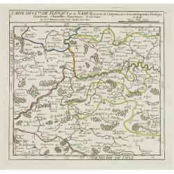
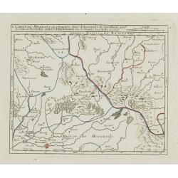
V. Carte des C.tes de Haynaut et de Namur. . .
Attractive small map illustrating part of the Walloon Region, centered on Charleroi. From Atlas Portatif Universel, by Robert de Vaugondy.Unrecorded state with erased dat...
- $30 / ≈ €25
Date: Paris, after 1748
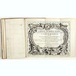
Comté d'Hollande, seigneurie d'Utrecht, comtés de Zelande, de Zutphen et duché de Brabant &c. Dressés sur les Mémoires faits par ordre des Estats Généraux et augmentés sur les Observations nouvelles.
Pocket atlas illustrated with a folded engraved title, a general map and 34 folded maps, including maps of the Netherlands, Belgium and parts of Germany.Provenance : Ex-l...
- $2400 / ≈ €2033
Date: Paris, Crépy, ca. 1748
Carte de L'Asie Mineure ou de la Natolie et du Pont Euxin
Johann Baptist Homann's well-engraved map of Asia Minor, the Black Sea ( Ponti Euxin), Crimea and a part of Greece. Depicts Turkey and the area surrounding the Black Sea ...
Date: Nuremberg, ca. 1748

Die Republic Holland oder die Verenigte Niederlande..
Charming map of the Netherlands, with inset maps of Novi Belgium area in America and Indonesia. With a fine cartouche.
Date: Leipzig, 1749
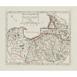
Royaume de Prusse et Prusse Rle. ou Polonoise.
On the left is Pomerania and the Desert of Waldow. At the top of the map is Memel and Samland. On the right side is the Biss River and Kautten. In the center of the map i...
- $125 / ≈ €106
Date: Paris, later than 1749
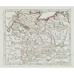
Cercle de la Basse Saxe, divisée par ses Principautés.
Small detailed map of the northern part of Germany. From Atlas Portatif Universel, by Robert de Vaugondy.Unrecorded state with erased date. Page 22 outside border top rig...
- $50 / ≈ €42
Date: Paris, later than 1749
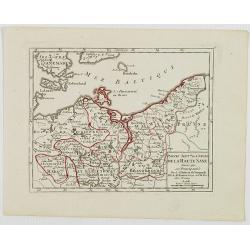
Partie Sept.le du Cercle de la Haute Saxe divisé par ses Principautés.
Small detailed map of the northeastern part of Germany, with Berlin at the bottom. Including part of Poland. From Atlas Portatif Universel, by Robert de Vaugondy.Unrecord...
- $75 / ≈ €64
Date: Paris, later than 1749
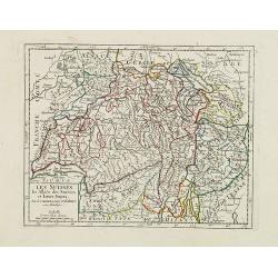
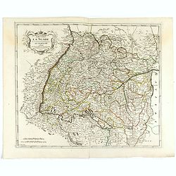
Les Suisses, les Alliés des Suisses et leurs Sujets.
Small detailed map of Switzerland. From Atlas Portatif Universel, by Robert de Vaugondy.Unrecorded state with erased date. Page 31 outside border top right. Mary Sponberg...
Date: Paris, later than 1749

Nieuwe kaart van het oostelykste deel van Holland. . .
Detailed map covering the area of Gouda, IJsselstein, s'Hertogenbosch, Zevenbergen, Dordrecht.
Date: Amsterdam, 1749

Royaume de Bohéme, Marquisat de Moravie, et Silésie Autrichenne.
Small detailed map of today Czech Republic. From Atlas Portatif Universel, by Robert de Vaugondy.Unrecorded state with erased date. Page 32 outside border top right. Mary...
Date: Paris, later than 1749

Das Hertzogthum Braband. . .
Charming map of the Dutch and Belgium province of Brabant. With a fine cartouche.
Date: Leipzig, 1749
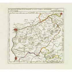
I. Carte du D.ché de Luxembourg ou sont les Frontieres du Namurois et du Lyegeois.
Charming small map representing part of the Walloon Region, delimited by the towns of Namur, Huy, Dinant and Ciney.From Atlas Portatif Universel, by Robert de Vaugondy. E...
Date: Paris, later than 1749
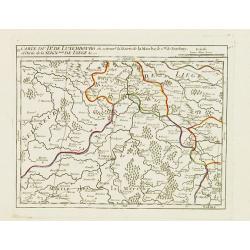
II. Carte du D.é de Luxembourg.. Seign.rie de Lyege &c.
Charming small map representing part of the Walloon Region, south to Liège. From Atlas Portatif Universel, by Robert de Vaugondy.Edited by : "Au dépôt de Géograp...
Date: Paris, later than 1749
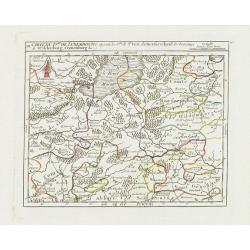
III. Carte du D.hé de Luxembourg.. Cronenburg &c.
Charming small map representing part of the Walloon Region, southeast to Limburg. From Atlas Portatif Universel, by Robert de Vaugondy.Edited by : "Au dépôt de Gé...
Date: Paris, later than 1749
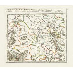
IV. Carte du Duché de Luxembourg où sont les Seign.ries de Lompré..
Charming small map representing part of Luxembourg, the southernmost province of Wallonia and of Belgium.From Atlas Portatif Universel, by Robert de Vaugondy. Edited by :...
Date: Paris, later than 1749