Browse Listings in Europe
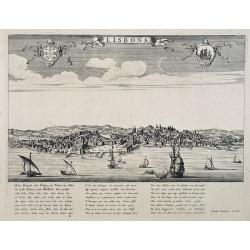
Lisbona.
A rare panoramic view of Lisbon with over the whole length of the lower part 3 columns of poems in Latin, Dutch and French.Published by Dancker Danckerts (1634-1666)Colle...
Date: Amsterdam, 1660
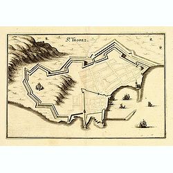
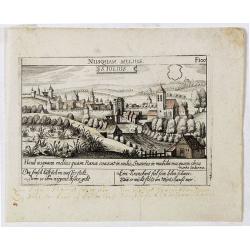
St Tropez.
Plan of St Tropez by M.Merian. Depicts a street layout and ships in harbour etc.
- $130 / ≈ €110
Date: Frakfurt, 1660

Neapolis.
A rare panoramic of Naples with over the whole length of the lower part 3 columns of poems in Latin, Dutch and French.Published by Dancker Danckerts (1634-1666).
Date: Amsterdam, 1660
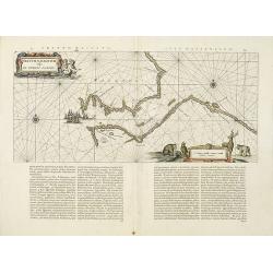
![Praga. [Prague]](/uploads/cache/28442-250x250.jpg)
Praga. [Prague]
A rare panoramic of Prague with over the whole length of the lower part 3 columns of poems in Latin, Dutch and French and a numbered key 1-34 to the principal buildings ...
Date: Amsterdam, 1660
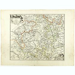
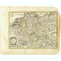
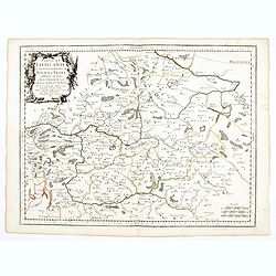
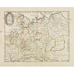
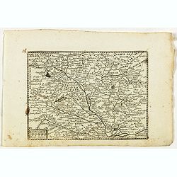
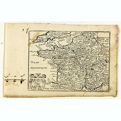
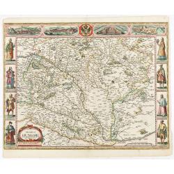
Champaigne et Brie etc.
A good engraved map of Champagne-Ardenne area, embellished with decorative title cartouche and scale cartouche with putti and surveying instruments. Paris, Metz, Reims, a...
- $150 / ≈ €127
Date: Paris, ca. 1660
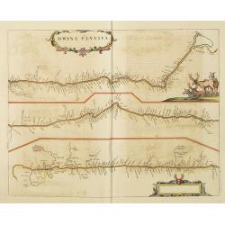
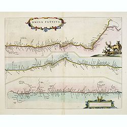
Dwina Fluvius.
An interesting strip-style map showing the course of the Dvina River in three sections from the Black Sea into the White Sea at Archangel. A group of reindeer and two str...
- $750 / ≈ €635
Date: Amsterdam, 1660
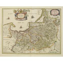
Prussia accurate descriptia a Gasparo Henneberg Erlichensi.
Prussia and the Baltic Region, with two large decorative cartouches, coat of arms and three sailing ships. As indicated in the title cartouche, the map was prepared by th...
- $900 / ≈ €762
Date: Amsterdam, 1660

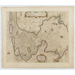
De Texel Stroom .. vant Marsdiep./ Caarte van De Mase...
Two decorative charts on one sheet, one depicting Texel and the entrance of the Zuider Zee with an inset showing the north coast of West-Friesland, the other depicting th...
Date: Amsterdam, 1660
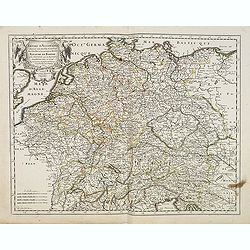
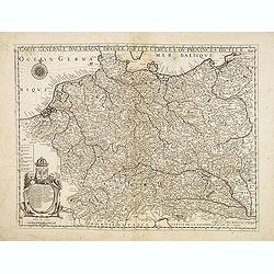
Carte generalle d'allemaigne nouvellement misse en françois et Ampliffiée de tous les Royaumes. . .
Attractive and rare map of Germany, the Low Countries, Austria, Moravia, Switzerland and part of Poland.
Date: Paris, 1632-1660
Nova Haec tabula Galliae. . .
Dated 1660. This handsome map of France is dedicated to Louis XIV, interesting in light of the nearly constant warfare between Louis and the Netherlands in the ensuing ye...
Date: Amsterdam, 1660
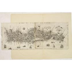
Il Regno Di Candia.
This rare map is based on the important map of Crete by Basilicata. The maps by Marco Boschini reached a wider audience than the few individuals for whom the Basilicata m...
Date: Venice, 1660
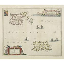
Sarnia Insula vulgo Garnsey et Insula Caesarea venacule Jarsey
Fine map depicting the English islands of Jersey and Guernsey is entitled : "Sarnica Insulavulgo Garnsey et Insula Caesarea vernacule Jarsey". In the cartouche...
- $475 / ≈ €402
Date: Amsterdam, 1660
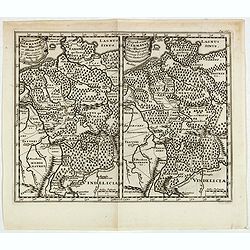
Populorum Germaniae . . .
Two maps of historical Germany on a single sheet. The two maps appear identical at first glance, but actually are a comparison of the region during the reigns of differen...
- $50 / ≈ €42
Date: Amsterdam, 1661

De Tesselstroom met de Gaten van Marsdiep./ De Mase met. . .
Three charts on one sheet depicting the entrances to the Zuiderzee between Holland, Texel and Vlieland. The entrances of the Maas with Rotterdam and in a small inset the ...
Date: Amsterdam, 1662
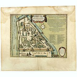
Kremlenagrad, Castellum urbis Moskvae . . .
Rare plan of the Kremlin, which appeared only in his Atlas Major. The map shows exceptional detail inside the heart of Moscow's inner walled fortress and the Kitai Gorod ...
- $2750 / ≈ €2329
Date: Amsterdam, 1662
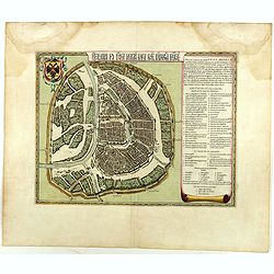
Benevole Lector, in hac tabulâ Urbis Moskuae . . .
Rare from his atlas Major. An extremely fine plan of Moscow, which is likely to have been based upon the survey ordered by Boris Fyodorovich Godunov. With a 60-point key,...
- $2750 / ≈ €2329
Date: Amsterdam, 1662
Fretum Nassovium vulgo de Straet Nassou.
Decorative map of the Nassau Strait, from the Atlas Major. Includes 2 compass roses, sailing ships, rhumb lines and 2 elaborate cartouches. Latin text below and on verso....
Date: Amsterdam, 1662
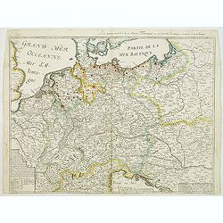
Nouvelle Carte d'Allemagne 1651. (29).
Scarce map of Germany, Poland and the Low Countries, published by Antoine de Fer in 1661 or 1662 in "Cartes de géographie revues et augmentées". With number 2...
- $50 / ≈ €42
Date: Paris, Antoine de Fer, 1657 but 1661 or 1662
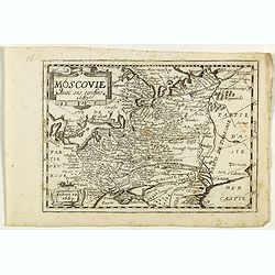
Moscovie. (34).
Scarce map of Muscovy and part of Poland and Lithuania published by Antoine de Fer in 1661 or 1662 in "Cartes de géographie revues et augmentées". The series ...
- $150 / ≈ €127
Date: Paris, Antoine de Fer, 1657 but 1661 or 1662

Nova XVII Provinciarum Inferioris Germaniae descriptio .
Extremely rare map of the Benelux by Frederick de Widt. Originally engraved and published by P.Kaerius in 1607. In 1662 the plate came in the possession of Frederick de W...
Date: Amsterdam, 1662
Dwina Fluvius.
An interesting strip-style map showing the course of the Dvina River in three sections from the Black Sea into the White Sea at Archangel. A group of reindeer and two str...
- $500 / ≈ €424
Date: Amsterdam, 1662

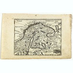
Norlandiae et quibies Gestricia et Helsingicae regiones Auct: Andrea Buraeo Sueco.
Uncommon map prepared by Anders Bure (1571-1646) with a dedicational cartouche to Gabriel Bengtsson Oxenstierna.The Atlas Maior is the epitome of decades of achievement b...
Date: Amsterdam, 1662

Het West Indisch Huys.
A decorative print of the West Indian House , the headquarters of the WIC, a place for meeting, trading and storage of spices and ship equipment. The maps and charts were...
Date: Amsterdam, J. van Meurs, 1663
La Livonie duché divisée en ses princip. parties Esten & Letten & c. / par le Sr. Sanson. . .
Fine map of the Baltic Coast from Riga to the Gulf of Finland, with the islands of Saaramaa and Hiiumaa off the coast of Estonia. Title cartouche in lower left corner and...
Date: Paris, 1663
![L'Espagne subdivisée en tous ses royaumes, princip[au]tés, seign[eu]ries. . .](/uploads/cache/33236-250x250.jpg)
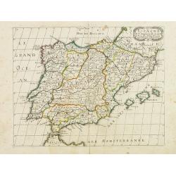
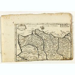
L'Espagne subdivisée en tous ses royaumes, princip[au]tés, seign[eu]ries. . .
Map of Spain, Portugal, Majorca and Minorca with original outline hand-color. Numerous place-names of counties, cities, towns, physical features.
- $400 / ≈ €339
Date: Paris, 1663
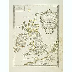
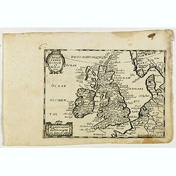
Carte des Isles Britanniques où sont les Royaumes d'Angleterre et d'Ecosse que nous appellons Grande Bretagne et celui d'Irlande avec les isles qui en sont proche . . .
General map of the British isles, with a fine title cartouche upper right with the date 1663 and the complete title reads : "Carte des Îles britanniques où se trou...
- $250 / ≈ €212
Date: Paris, 1663

Pas-Caart van de ZUYDER-ZEE, Texel ende Vlie-stroom.als mede 't Amelander gat (Hollandt/Vrieslandt)
An attractive chart of the Zuiderzee, now the inland water het IJselmeer.HOLLANDT / VRIESLANDTPas-Caart van de Zuyder-Zee, Texel ende Vlie-stroom.als mede 't Amelander g...
- $1000 / ≈ €847
Date: Amsterdam, c. 1665
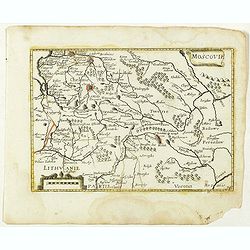
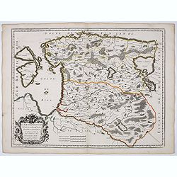
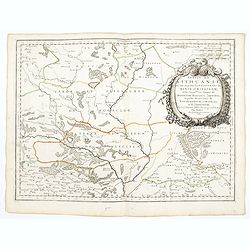
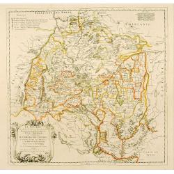
Partie de Lithuanie ou est en partie le Palatinat de Nowogrodeck Litawiski, subdivisé en leurs Chastellenies , le Palatinat de Bressici en Polesie, avec les duchés de Neswies, et Slusck, et partie du Palatinat de Minsk.
Scarce regional map, centered on Pinsk and showing Polish Lithuania, including part of modern Poland, Belarus, etc. This edition carries the date 1665. Nicolas Sanson was...
Date: Paris, 1665
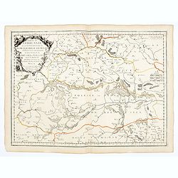
Partie de Lithuanie où sont les palatinats de Poloczk, Witepsk, Mseislaw, et partie de Minsk avec le duché de Smolensko.
Scarce and fine map of Belarus, including Smolensko in Russia and the region northeast of Minsk. This edition carries the date 1665 and the publishers address "A Par...
Date: Paris, 1665
Empire d'Allemagne, divisé en ses dix Cercles ... Royaume de Boheme...
Covering Germany, Low Countries, Poland, Switzerland, Austria and Czech Republic. Nicolas Sanson was to bring about the rise of French cartography, although the fierce co...
- $250 / ≈ €212
Date: Paris, 1665
Pascaart..de Zuyder-Zee, Texel..Vlie-stroom..'t Amelander…
An eye-catching chart of the Zuiderzee with east to the top.Pieter Goos (ca. 1616-1675) was one of the most important cartographer, engraver, publisher and print seller o...
Date: Amsterdam, 1666

Pascaerte Van't Westelyckste der Middelandsche Zee. . .
An eye-catching chart of the western part of the Mediterranean Sea.Pieter Goos (ca. 1616-1675) was one of the most important cartographer, engraver, publisher and print s...
Date: Amsterdam, 1666
De custen van Noorwegen, Finmarcken, Laplandt, Spitsbergen . . .
Detailed sea chart of Norway, Finland, Iceland, Spitsbegen and part of Scotland published by Hendrik Donker. The Greenwich meridian is in the middle of the chart. The ch...
Date: Amsterdam, 1666

Pas-Caart van de Oost Zee verthooende alle de ghelegenheydt tusschen t Eylandt Rugen ende Wyborg. . .
An eye-catching chart of the Baltic Sea. Engraved by Gerard Coeck.Pieter Goos (ca. 1616-1675) was one of the most important cartographers, engravers, publishers and print...
Date: Amsterdam, 1666

Pascaerte Van't Westelyckste der Middelandsche Zee. . .
An eye-catching chart of the western part of the Mediterranean Sea.Pieter Goos (ca. 1616-1675) was one of the most important cartographer, engraver, publisher and print s...
Date: Amsterdam, 1666

Cajanie, ou Bothnie Orientale Tirée de celles d'Andr Burae et de Isaac Massa. . .
Map of the Northern part of Gulf of Bothnia, today's border area between Sweden and Finland. The map derive from the work of the Swedish cartographer Andreas Bureus and I...
Date: Paris, P.Mariette, 1666
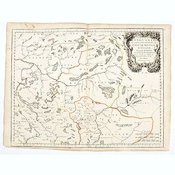
Partie de Lithuanie ou sont en partie les Palatinats de Wilna, et Troki, subdivisés en leurs Chastellenies et partie du Palatinat de Minsk.
Fine map of Lithuania. This edition carries the date 1665 and the publishers address "A Paris, chez Pierre Mariette, rue Saint Jacques a l'Esperance…"Nicolas ...
Date: Paris, 1666
Partie de Lithuanie ou sont en partie les Palatinats de Minsk, et Mseislaw, we les Seign.Ries ou Terres de Rohaczow, Rzeczica, Zernobee, et partie des. . .
Fine map of Lithuania. This edition carries the publishers address "chez l'Autheur Avec privilege pour vingt ans 1666". Nicolas Sanson was to bring about the ri...
Date: Paris, 1666
Illyricum Orientis In quo Partes II. Moesia et Thracia. Provinciae XI.
Attractive historical map of the area west of the Black Sea, today's Bulgaria, Rumania, etc. Based on the cartography of Nicolas Sanson and published by P.Mariette. With ...
- $400 / ≈ €339
Date: Paris, 1666
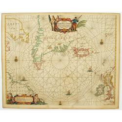
Pascaerte van Groen-Landt, Yslandt, Straet Davids en Ian Mayen eylandt. . .
An eye-catching chart of the North Atlantic, showing prominent Greenland, Iceland, and parts of the North American continent. The map is decorated with a large figurative...
- $1000 / ≈ €847
Date: Amsterdam, 1666
Carte générale d'Alemagne divisée par les cercles ou provinces d'icelle.
Rare and detailed map of Germany, Poland and Austria, engraved by H. le Roy in 1643 or 1666 for Jacques L'Agniet. The publishing house Jollain bought the copper plate and...
Date: Paris, 1666

Pascaert van Engelant Van t'Voorlandt tot aen Blakeney waer in te sien is de mont vande Teemse.
Two charts on one sheet. One decorative sea chart of the southeast coast of England with an inset of the Thames till London, embellished with two title cartouches, a ship...
Date: Amsterdam, 1666

Cust van Hollant Tussen de Maes ende Texel.
Uncommon chart of the coast of Holland, including the southern tip of Texel. East at the top. Two fine compass cards, soundings and a large Bree Veerthien offshore.Piete...
Date: Amsterdam, 1666

Paskaert vande Bocht van Vranckrijck Biscajen. . .
An eye-catching chart of the coast of Bretagne from Brest running south till the coast of Biscay in Northern Spain.Including the towns of Ferrol in the west, Gijon, Santa...
Date: Amsterdam, after 1666

Het Canaal tusschen Engeland en Vranciick.
An eye-catching chart of the Channel.Pieter Goos (ca. 1616-1675) was one of the most important cartographers, engravers, publishers and print sellers of Amsterdam. His wi...
Date: Amsterdam, after 1666

Hollandiae pars septentrionalis, Vulgo Westvriesland..
Based on the work of B.F.van Berckenrode, this fine map, orientated west to the top of the sheet, includes Kennemerland and Hollands Noorderkwartier and is a reasonably u...
Date: Amsterdam, ca. 1667
Russie Blanche ou Moscovie.
Map of the European part of Russia prepared by N.Sanson and published by Pierre Mariette.Published in an early edition of the small Sanson atlas L'Europe Dediée a Monsei...
Date: Paris, P. Mariette, 1667
Espagne. . .
Map of Spain and Portugal prepared by N.Sanson and published by Pierre Mariette.Published in an early edition of the small Sanson atlas L'Europe Dediée a Monseigneur . ....
Date: Paris, P. Mariette, 1667
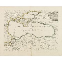
Mer Noire ou Mer Maievre, . . .
Map of the Black Sea prepared by N.Sanson and published by Pierre Mariette.Published in an early edition of the small Sanson atlas L'Europe Dediée a Monseigneur . . . Le...
Date: Paris, P. Mariette, 1667
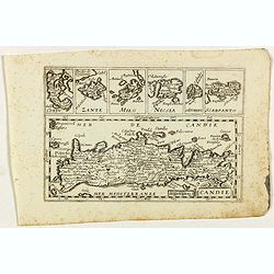
Candie.
Rare map of Crete with in top six small inset maps of Greek islands, published by Jollain in 1667. Published in "Trésor Des Cartes Geographiques Des Principaux Esta...
- $350 / ≈ €296
Date: Paris, 1667
Moree jadis Peloponese.
Rare map of Peloponnese, published by Jollain in 1667. Published in "Trésor Des Cartes Geographiques Des Principaux Estats de Lunivers".This atlas is based upo...
- $300 / ≈ €254
Date: Paris, 1667
Moscovie avec ses confins.
Rare map of Russia, published by Jollain in 1667. Published in "Trésor Des Cartes Geographiques Des Principaux Estats de Lunivers".This atlas is based upon Boi...
- $450 / ≈ €381
Date: Paris, 1667
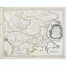
Hongrie.
Rare map of Hungary, published by Jollain in 1667. Published in "Trésor Des Cartes Geographiques Des Principaux Estats de Lunivers".This atlas is based upon Bo...
- $300 / ≈ €254
Date: Paris, 1667
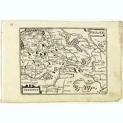
Russie.
Rare map of Russia, published by Jollain in 1667. Published in "Trésor Des Cartes Geographiques Des Principaux Estats de Lunivers".This atlas is based upon Boi...
- $250 / ≈ €212
Date: Paris, 1667
Angleterre Ecosse et Hibernie.
Rare map of the British islands, published by Jollain in 1667. Published in "Trésor Des Cartes Geographiques Des Principaux Estats de Lunivers".This atlas is b...
- $250 / ≈ €212
Date: Paris, 1667
Norvege et Suede.
Rare map of Norway, Sweden and Finmark published by Jollain in 1667. Published in "Trésor Des Cartes Geographiques Des Principaux Estats de Lunivers".This atla...
- $250 / ≈ €212
Date: Paris, 1667
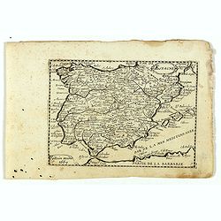
Espagne.
Rare map of Spain and Portugal, published by Jollain in 1667. Published in "Trésor Des Cartes Geographiques Des Principaux Estats de Lunivers".This atlas is ba...
- $200 / ≈ €169
Date: Paris, 1667
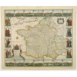
France nouvellement descripte.
Rare map of France, published by Jollain in 1667. Published in "Trésor Des Cartes Geographiques Des Principaux Estats de Lunivers".This atlas is based upon Boi...
- $150 / ≈ €127
Date: Paris, 1667
Portugal et Algarve.
Rare map of Portugal, published by Jollain in 1667. Published in "Trésor Des Cartes Geographiques Des Principaux Estats de Lunivers".This atlas is based upon B...
- $150 / ≈ €127
Date: Paris, 1667
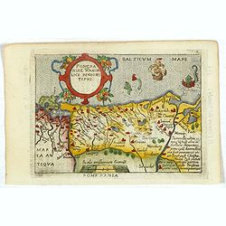
Pomeraniae Wandalice Regionis Tipus.
Miniature map of Pomerania embellished by rich cartouche, vessel and sea monsters in the Baltic. Abraham Ortelius (1527-1598) was a cartographer and publisher, who is bor...
- $250 / ≈ €212
Date: Antwerp, 1667

Pascaart van de west cust van Engeland en Wales Van S. Davids Point tot de Moul van Dalway.
Rare Doncker's sea chart of the Irish Sea with the west Coast of England (Liverpool), the Island of Man and the western-most tip of Northern Ireland (Bangor) and Souther...
Date: Amsterdam, 1660-1668
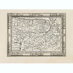
Carte du Comté de Flandre. . .
Decorative map of Flanders from Plans, et Profils des principales villes.. by Ch. De Beaulieu. Etched by mr. Romeijn de Hooghe.
- $80 / ≈ €68
Date: Paris, 1668

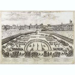
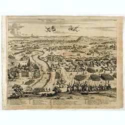
Course de Baque et Disposition des Quadrilles, dans l'Amphiteatre seconde journée.
An early and intriguing engraving recording one of the most celebrated and spectacular festivals held at Paris by the young Louis XIV. The multi-day tournament took place...
Date: Paris, imprimerie royale, 1670
Comparse des Cinq Quadrilles dans l'Amphitheatre.
An early and intriguing engraving recording one of the most celebrated and spectacular festivals held at Paris by the young Louis XIV. The multi-day tournament took place...
Date: Paris, imprimerie royale, 1670
![Nova & exacta Chorographia Latii sive Territorii Romani iuxta veterem et novum situm parallela nomimu[m] comparatione elaborata.](/uploads/cache/44863-250x250.jpg)
Nova & exacta Chorographia Latii sive Territorii Romani iuxta veterem et novum situm parallela nomimu[m] comparatione elaborata.
Map of central Italy, centered on Rome from "Latium" by A. Kircher and designed by Innocenzo Mattei. The title cartouche in the lower right, small legend with 1...
Date: Amsterdam, 1671
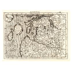
Livonia.
Finely engraved map of the Baltic states Estonia and Latvia filled with forests, rivers and lakes. French text on verso. Engraved by Petrus Kaerius for Janssonius' pocket...
Date: Amsterdam, Jan Cloppenburgh, 1673
La Souabe.
Fine map of Swabia.This edition carries the date 1674 and the publishers address A PARIS chez l'Autheur aux Galleries du Louvre. Nicolas Sanson was to bring about the ris...
- $75 / ≈ €64
Date: Paris, 1674
![[Lot of 8 maps and prints] Norvegiae Maritimae ab Elf-burgo ad Dronten / Pascaert van Noorwegen streckende van Elf-burg tot Dronten.](/uploads/cache/84130-250x250.jpg)
[Lot of 8 maps and prints] Norvegiae Maritimae ab Elf-burgo ad Dronten / Pascaert van Noorwegen streckende van Elf-burg tot Dronten.
Norvegiae Maritimae ab Elf-burgo ad Dronten / Pascaert van Noorwegen streckende van Elf-burg tot Dronten. Frederick de Wit's fine sea chart of southern Norway. An attr...
- $900 / ≈ €762
Date: Amsterdam, 1675
The siege of Lagny.
Very rare etching of the siege of Lagny-sur-Marne by the Duc of Parma. Etched by Johann Azelt (1654-1692). A similar print but with the number in the upper right corner i...
- $150 / ≈ €127
Date: Nuremberg, ca 1675
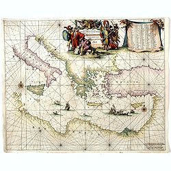
Orientalior districtus Maris Mediterranei.
Beautiful chart of the eastern part of the Mediterranean. Including Italy, the north coast of Africa and part of the Black Sea.The entire sheet is covered with rhumb line...
Date: Amsterdam, 1675
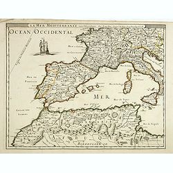
La mer mediterrannée, vers l'Occident. . .
Uncommon map of the western Mediterranean Sea, including France, Spain, Italy, Corsica Sardinia and North Africa. In upper left corner a large sailing vessel.
- $300 / ≈ €254
Date: Paris, 1676

Carte de L'Empire d'Alemagne par P. Duval. . .
Uncommon map of Germany and the eastern part of Poland. In upper right corner a dedicational cartouche with coat of arms and dedication to Saint-Laurens.
Date: Paris, 1676
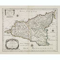
La Sicile, avec les anciens noms de presque toutes ses Places, Rivières, Chateaux &c. et diverses observations nouvelles . . .
Uncommon map of Sicily with fine title cartouche lower right . Original date of 1675 now altered to 1676.More about [+]
Date: Paris, 1676
Pas-Caart van Hispangien vertoonde de Custen van Granade…
An eye-catching chart of Spain and Portugal, including a large part of Brittany and the southwestern coast of France, including Isle de Reé , Isle Saint Martin ...Pieter...
Date: Amsterdam, 1669-1676

A new mape of Ye XVII Provinces of Low Germanie.
Showing all 17 Provinces of the Netherlands before the split between Spain and the Protestant Provinces under the House of Orange.The map was first published. At the same...
Date: London, 1676

EUROP, and the cheife Cities contayned therin described. . .
A good impression from an early edition of this famous and decorative "carte à figures"- map from the first world atlas produced by an Englishman - John Speed'...
Date: London, 1627 - 1676
The mape of Hungari newly augmented by John Speede.
A wonderful carte-a-figures map of ‘Hungari’, comprising modern-day Hungary and parts of Slovakia. Showing two sets of four costumed figures on each side of the map a...
Date: Londres, Bassett and Chiswell, 1626 / 1676

Paris, Lutetia, Parisii, Ville Capitale du Royaume de France.
View of Paris seen from the hill "Belleville based on that of Merian (1616) but updated with the new gates Saint-Denis and Saint-Martin. With a key 1-78 and A-Z. Sur...
Date: Paris, after 1676

Paskaerte Vande Bocht van Vranckrijk Biscajen en Galissen
An eye-catching chart of Spain and France, including a large part of Brittany, including Isle de Reé , Isle Saint Martin ...Shows the gulf of the northeast Atlantic Ocea...
Date: Amsterdam, 1669-1676
S. Iulius.
A very nice view of the castle. On the foreground, several frogs are depicted with a verse in two languages underneath the picture.The poet and topographer from Comothau,...
- $60 / ≈ €51
Date: Frankfurt 1623-1678