Featured Listings in America > America250
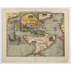
Die neüwen Inseln/ so hinder Hispanien gegen Orient bey dem land Indie ligen.
The earliest and one of the most important separate maps to show both Americas. Although it was not the first map to use “America” as a designation for the New World, it ...
Date: Basle 1561
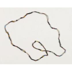
Dutch Trade Bead.
An extremely rare necklace made from authentic early 17th-century glass beads produced in the Netherlands. This rare and early Dutch Trade bead is built up from irregular...
Date: Middelburg, before 1623

Americae Nova Tabula.
The delineation of the coast and the nomenclature on both the Pacific and Atlantic coasts are basically Spanish in origin and follow the maps of Ortelius and Wytfliet. To...
Date: Amsterdam, 1645

Novi Belgii novae que Angliae nec non partis Virginiae..
With the arrival of Dutch and other European colonists, the landscape of New Netherland changed dramatically. The third state, with Fort Kassimier and Philadelphia, and n...
Date: Amsterdam, 1684
![America Settentrionale Colle Nuove Scoperte Sin All Anno 1688. . . (together with] America meridionale . . .](/uploads/cache/49063-250x250.jpg)
America Settentrionale Colle Nuove Scoperte Sin All Anno 1688. . . (together with] America meridionale . . .
Gorgeous example of Coronelli's famous four- sheet map of America. One of the best examples of California as an island. The map also includes extensive annotations on the...
Date: Venice, 1690

Carte des Possessions Françoises et Angloises dans le Canada, et partie de la Louisiane.
First state of this separately published map of the European Colonies in the New World east of the Mississippi River. This map was published in 1756 to provide informatio...
Date: Paris, 1756

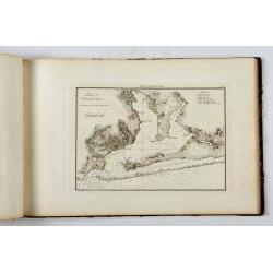
The Harbour of Casco Bay and Islands Adjacent Bt Capt. Cyprian Southicke.
The earliest printed chart of Casco Bay, an inlet of the Gulf of Maine on the southern coast of Maine, New England. First issued in 1720 by Mount and Page, it remained in...
Date: Dublin, 1767

A Map of the most Inhabited part of New England containing the Provinces of Massachusetts Bay and New Hampshire, with the Colonies of Connecticut and Rhode Island.
A copper engraving in four sheets, published in Georges Louis Le Rouge, in his "Atlas Ameriqua in Septentrional Contenant les details des differentes provinces, de c...
Date: Paris, 1777

Connecticut and Parts adjacent at Amsterdam. .
A nice example of this early map of the state of Connecticut, with part of Rhode Island to the east, Long Island to the south, and New York to the east. Rivers, roads, to...
Date: Amsterdam, 1780

ETATS-UNIS DE L'AMÉRIQUE SEPTENTRIONALE Avec LES ISLES ROYALE, DE TERRE NEUVE, DE S.T JEAN, L'ACADIE, &c. 1785. Supplement a l'Atlas de M. Robert de Vaugondy a Paris Ches Boudet Ingenieur du Roi.
A map of the eastern United States with "Supplément à l'atlas de M. Robert de Vaugondy à Paris chez Boudet Imprimeur du Roi", in place of the attribution to Del...
Date: Paris, 1785

Carte D'Amerique Divisée en ses Principaux Pays. . .
Rare. Uncommon and decorative wall map of America, prepared by Clouet. With superb decorative borders, 170mm wide at the sides and 150mm at the bottom, containing twenty ...
Date: Paris, Cadiz, 1785

Bison Iubatus.
Etching of a bison by Leendert Brasser (1727 - 1793) after a painting of the Dutch artist Gerrit van den Heuvel.An early portrait of a bison, etched by Leendert Brasser (...
Date: Rotterdam, 1766-1793
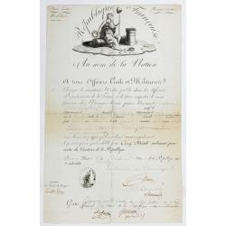
Passeport.
Passport for the United States in the name of Madeleine Lavit Femme Lory, issued by the Commission of Interior Relations and approved by the Committee of Public Safety.Th...
Date: Paris, 1795

United States of North America. Carte des Etats-Unis de l'Amerique Septentrionale / copiée et gravée sur celle d'Arrowsmith, corrigée et considérablement augmentée... par P. F. Tardieu...
FIRST EDITION. An impressive wall map here in 4 unjoined sheets and large margins. RARE in these untouched, full sheets. Recorded examples are usually offered as folding ...
Date: Paris: An XI - 1802
Portulano de la Ameririca Setentrional construido en la direccion de tabajos.
The "Portulano de la America Setentrional", is an exceedingly rare Spanish sea atlas featuring charts of the Caribbean and the Gulf of Mexico. It was developed ...
Date: Madrid, 1818
![Etats-Unis de L'Amerique Septentrionale. [Two sheets in manuscript ]](/uploads/cache/03972-250x250.jpg)
Etats-Unis de L'Amerique Septentrionale. [Two sheets in manuscript ]
Two sheets giving detailed information in French about the population in 1810, principal cities, products of industry and commerce, the financial situation for 1818, etc....
Date: France, ca. 1819

Missions et Résidences dans la Partie Septentrionale de l'Amérique Contenant 50 Jésuites.
Very rare missionary map of North America from "Atlas Universel indiquant les établissemens des Jésuites: avec la manière dont ils divisent la terre, suivi desévénem...
Date: Paris, Ambroise Dupont , 1826
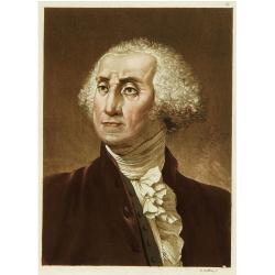
Portrait de George Washington.
Portrait of the first president of the United States of America.From Giulio Ferrario's work Le Costume ancien et moderne ou histoire du gouvernement, de la milice, de la ...
Date: Milan 1827

A-Na-Cam-E-Gish-Ca. A Chippeway Chief.
Half-length portrait of Anacamegishca, bare-chested, wearing a blanket and a peace medal. A-Na-Cam-E-Gish-Ca (1785-1862) - was a Chippewa (Ojibwe) Native American chief. ...
Date: Philadelphia, 1837

Histoire de la Guerre Civile en Amerique par M. Le Comte de Paris, Ancien Aide de Camp du General Mac Clellan (McClellan). ...
The maps are chromolithographs and offer a fascinating view of the Civil War battlegrounds. Vorzet made these 30 maps to accompany Louis Phillipe d'Orleans' (Comte de ...
Date: Paris. Michel Levy Freres, 1875

Dutton Map of the Grand Canyon, Arizona (in 4 joined sheets)
An important 1882 map of the Grand Canyon, Arizona, published in "Atlas To Accompany The Monograph On The Tertiary History Of The Grand Canon District By Capt. Clare...
Date: Julius Bien and Co., 1882
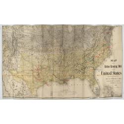
Map showing the cotton growing belt in the United States Prepared for and copyrighted by Geo. H.Mc.Fadden & Bro., cotton merchands based in Phiiladelphia, USA 1892.
The cotton-growing Belts in the Southern States for 1892 A rare map showing the cotton-growing Belts in the Southern States for 1892. Prepared for and copyrighted by G...
Date: Philadelphia, 1892

Rooseveld rekende verkeerd ! De vangarmen van De Dollarpoliep worden afgesneden. . .
A remarkable Anti-American Dutch World War II propaganda poster by Lou Manche, showing a pink octopus representing the United States, with its tentacles cut off in the we...
Date: The Netherlands, 1942
