AMERICA 250

America will celebrate its 250th anniversary of the United States Declaration of Independence throughout 2026, culminating on Independence Day – July 4, 2026.
Before and after the founding of America, European and American mapmakers produced maps that influenced the course of world history. They were used to settle conflicts, during battles, to construct roads or canals, on essential shipping routes, and as propaganda tools.
Maps were (and are) essential for war, sieges, exploration, and commercial activities. We use this opportunity to bring some important maps in the making of America to the attention of our viewers.
 The Battle of Yorktown, Sep 28 - Oct 19, 1781
proved to be the decisive engagement of the American Revolution. The British surrender forecast the end of British rule in the colonies and the birth of a new nation—the United States of America.
"The Battle of the Chesapeake Bay was one of the decisive battles of the world," writes historian Michael Lewis in "The History of the British Navy."
Before it, the creation of the United States was possible, after it, it was certain.
After six years of war, both the British and Continental armies were exhausted. The British, in hostile territory, held only a few coastal areas in America. On the other side of the Atlantic, Britain was also waging a global war with France and Spain. The American conflict was unpopular and divisive, and there was no end in sight. For the colonies, the long struggle for independence was leading to enormous debt, food shortages, and a lack of morale among the soldiers. Both sides were desperately seeking a definitive victory.
General George Washington and his Continental Army had a decision to make in the spring of 1781. They could strike a decisive blow to the British in New York City or aim for the south, in Yorktown, Virginia, where Gen. Charles Lord Cornwallis’s troops were garrisoned. Washington and his French ally, Lt. Gen. Comte de Rochambeau, bet on the south, where they were assured critical naval support from a French fleet commanded by Adm. Comte de Grasse.
The Allied armies marched hundreds of miles from their headquarters north of New York City to Yorktown, making theirs the largest troop movement of the American Revolution. They surprised the British in a siege that turned the tide toward an American victory in the War for Independence.
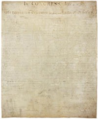
Declaration of Independence
Thomas Jefferson’s words in the Declaration of Independence sent an enduring message to all the world’s peoples:
“We hold these truths to be self-evident, that all men are created equal, that they are endowed by their Creator with certain unalienable Rights, that among these are Life, Liberty and the pursuit of Happiness.”
Mapping of America
Before and after the founding of America, European and American mapmakers produced maps and many have influenced the course of world history. They were used to settle conflicts, during battles, to construct roads or canals, on essential shipping routes, and as propaganda tools. or essential for war, siege, exploration, and commercial purposes.
Below are some of our favorite items that are awindow to the making of America.
 1513 One of the first glimpses of the American continent is shown on the so-called Admiral's Map; the first of two maps in Waldseemuller's atlas that relate to New World discoveries. This world map gives a more accurate outline of eastern Asia than Ptolemy. It contains Greenland, which is attached to Europe, but only a tiny section of North America, meant to represent either Newfoundland or Labrador. With the Caribbean islands of Spagnolla [Haiti/Dominican Republic] and Isabella [Cuba], an unnamed small piece of land in the mid-Atlantic with an eastern coastline delineated.The coastline of South America is left unfinished, and only five place names are given. [MORE] |
 1513 Waldseemuller's map of the New World shows the Atlantic coast of the Americas from latitudes 35 degrees south to 55 degrees north, including 20 place-names on the North American coastline. An apparent Gulf of Mexico, the Florida peninsula, Cuba as Isabella and Hispaniola, and across the Atlantic portions of the British Isles, Spain and Portugal and Africa are visible. [MORE] |
 1540
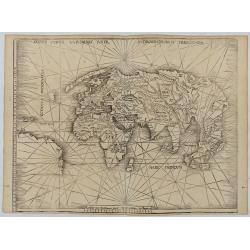
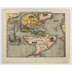
1540The earliest and one of the most important separate maps to show both Americas. Although it was not the first map to use “America” as a designation for the New World, it was the appearance of the name in the 'Cosmographia,' an immensely popular work which went into some forty editions over a hundred years. [MORE] |
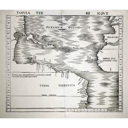
 1570 When the map was first published by Abraham Ortelius at Antwerp in 1570, it was the best map of the Americas available. It was in fact the first of its kind to achieve-wide circulation through an atlas. The map shaped the face of America for a large public for more than 50 years. [MORE] |
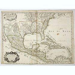
1703 It was the first printed map to portray accurately the course and mouth of the Mississippi River. Showing the explorations of Iberville and his men on the Gulf Coast and the lower reaches of the Mississippi and Red rivers, and the Indian villages in East Texas where the Spanish constructed their missions and presidios. [MORE] |
 1755 The Mitchell map is considered the single most important map in 18th-century American history. It was used as a primary reference for nearly every treaty and boundary dispute in colonial North America from the French and Indian War (1754 - 1763) through the late 19th century. Mitchell's map was first published by Andrew Millar in 1755 - one year after the outbreak of the French and Indian War. [MORE] |
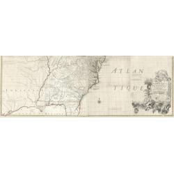
 1756 First state of this separately published map of the European Colonies in the New World east of the Mississippi River. This map was published in 1756 to provide information on the French-Indian wars. Scale ca. 1:3,900,000. In the lower right corner, a large inset of the Carolinas, Georgia, Florida and the Gulf Coast. Based on John Mitchell's map of North America. [MORE] |
| The Declaration of Independence, signed on July 4th, 1776 |
 1776 The earliest maps to use the name Etats-Unis (United States) in the title. The Declaration of Independence, signed on July 4th, 1776, was titled "The Unanimous Declaration of the Thirteen United States of America," while later in the text it also referred to the "United Colonies." |
 1778
|
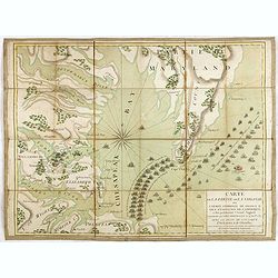
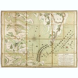 1781 Extremely rare map of the lower Chesapeake Bay emphasizes the Revolutionary War naval battle that took place off the Virginia coast prior to General Charles Cornwalllis's surrender at Yorktown, October 19, 1781. Engraved by Etienne Claude Voysard (1746-1812) and published by Esnauts et Rapilly in Paris. It graphically illustrates the French blockade at the entrance to the Chesapeake Bay, preventing the combined fleets of English Admirals Thomas Graves and Samuel Hood from providing reinforcements to Cornwallis. The battle marked a turning point in American history with the remainder of hostilities between France and Great Britain taking place elsewhere. [MORE] |
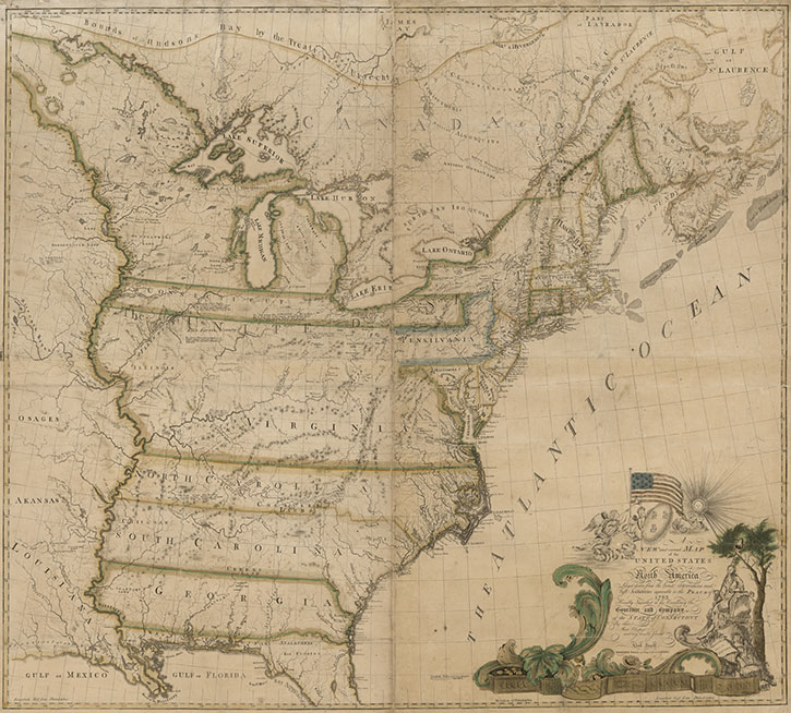 1784 1784In the years following the end of the Revolutionary War, Americans took their first hesitant steps towards cartographic independence, with several fine large-scale maps of the United States by Abel Buell, William McMurray, and Abraham Bradley Jr. The first map of the United States compiled, engraved, and printed by an American was Abel Buell's A NEW AND CORRECT MAP OF THE UNITED STATES OF NORTH AMERICA LAYD DOWN FROM THE LATEST OBSERVATIONS AND BEST AUTHORITY AGREEABLE TO THE PEACE OF 1783, published in 1784. The map is included in Schwartz & Ehrenberg and other map histories, and shows the American flag printed on a map for the first time. This landmark map of extraordinary significance to the historical record of the United States was published by Abel Buell in 1784. Notably, this is the first map of the newly independent United States compiled, printed, and published in America by an American. Additionally, it is also the first map to be copyrighted in the United States. Only seven copies are known to exist and survive in major institutions in the United States, the United Kingdom, and Spain. An excellent example of the Buell map was sold in 2010 for $1.8 million to the philanthropist David M. Rubenstein, who has lent it to the Library of Congress. In 1770, Buell moved to New Haven, Connecticut and went to work for cartographer Bernard Romans. After the American Revolutionary War ended, Buell used the minting machine he had invented to mint the State of Connecticut's first official pennies. By 1784, Buell cast his own typeset and published the first American-made map of the United States. The wall map measured 43 x 48 inches, was printed in four sections, and the hand-applied watercolor gave the map its color. In 1800, Buell went to England on behalf of the State of Connecticut to purchase copper. While there, he gained both practical knowledge and a sum of money that allowed him, upon his return, to establish one of Connecticut's first cotton mills. |
 1802 Tardieu's map is a direct copy of Arrowsmith's "Map of the United States" except for certain parts (mentioned by Tardieu in his "Note" above the title) that Tardieu has altered and improved based on other sources. The map shows the eastern seaboard and extends westward as far as where the Missouri River crosses 97o lat. Showing the United States and Canada. [MORE] |
