Search Listings matching "australia"
Benedict. Arias Montanus Sacrae Geographiae Tabulam Ex Antiq
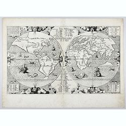
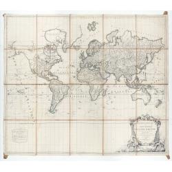
THE EXTREMELY RARE FIRST STATE landmark world map, famed for its depiction of the Australian landmass.One of the earliest printed maps to depict the “terra incognita�...
Date: Anvers 1571 /1572
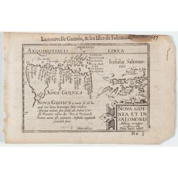
Nova Guinea et In. Salomonis
Early miniature map of New Guinea from the Caert-Thresoor and engraved by the Dutch master-engraver Petrus Kaerius. The first edition was printed in Middelburg by Barent...
Date: Amsterdam, 1606

Nova Totius Terrarum Orbis Geographica..
The first of four states of the map. French text on verso. One of the most beautiful world maps ever engraved and one of the most influential in promulgating the Californ...
Date: Amsterdam, 1630-1633
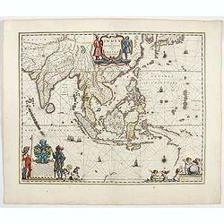
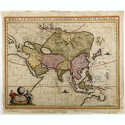
India quae Orientalis dicitur, et insulae adiacentes.
Extending from India to Japan and showing parts of Australia. It is indeed one of the first printed maps to show identifiable parts of Australia. It was not revised until...
Date: Amsterdam, 1644

Nouvelle et exacte description du globe terrestre reveue corrigée et augmente´e suivant les derniéres relations des Anglais et Hollandois. Par Guillaume Blaeu 1645.
Extremely rare and decorative "carte a figures" world map published by Anthoine de Fer. The double hemisphere world map is surrounded by constellations of the A...
Date: Paris, 1645

Carta terza Generale del' Asia.
Rare first state of this important chart showing part of the north coast of New Guinea and islands of the Pacific Ocean. To the north of Japan the landmass of Isola di Ie...
Date: Florence, 1646

Mar del Zur, Hispanis Mare Pacificum.
Janssonius' fine chart of the Pacific including the west coast of America with California shown as an island, Japan and a small Australian coastline. This is the earliest...
Date: Amsterdam, 1650
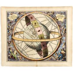
Situs Terrae Circulis Coelestibus circundatae..
A celestial chart depicting a large globe centered on Australia and the Pacific, with California depicted as an island, and South East Asia encircled by the zodiacal band...
Date: Amsterdam, Janssonius, 1660
![Carte de L'Amerique… / Carte Nouvelle de L'Europe Asie & Afrique… [Two sheets]](/uploads/cache/49267-250x250.jpg)
Carte de L'Amerique… / Carte Nouvelle de L'Europe Asie & Afrique… [Two sheets]
Rare. Two hemispheres printed on two sheets. A single decorative cartouche on each carries the title concluding with the imprint recorded above, and around each hemispher...
Date: Paris, 1661
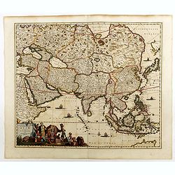
Asiae Nova Apud Hudo Allardt. / Nova et exacta Asiae geograpicha descriptio.
Rare map of Asia, with relief shown pictorially. Shows Great wall of China and the mythical island of Yedso north of Japan. Title at head of map: Nova et exacta Asiae geo...
Date: Amsterdam, 1660-1665

Paskaerte Zynde t'Oosterdeel Van Oost Indien, met alle de Eylanden daer ontrendt geleegen van C. Comorin tota aen Iapan.
An eye-catching chart of Pieter Goos' sea chart of Australia, Southeast Asia, China, Japan, Korea and India. The chart shows the regions from Cape Comorin (Southern India...
Date: Amsterdam, 1669

French composite atlas made up of rare maps published by Parisian editors from the 17th century , mainly by G. Jollain including scarce maps of America.
A rare French composite atlas including 90 maps, published by Parisian publishers from the 17th century, mainly by Gérard I Jollain, or by maps bought from Dutch publish...
Date: Paris, ca. 1675
Accuratissima totius Asiae tabula..
The map includes a detailed depiction of South East Asia and the Far East. The northern tip of Australia (Hollandia Nova) is shown as are the important discoveries made t...
Date: Amsterdam, 1680

Isole dell'Indie. . .
A beautiful and flamboyantly engraved large-scale map of the East Indies, including the Malay Peninsula, Cambodia, the Philippines and all of Indonesia and the Spice Isla...
Date: Venice, 1696
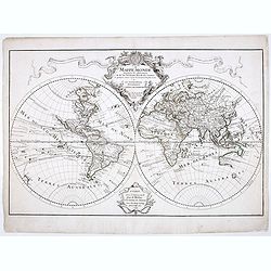
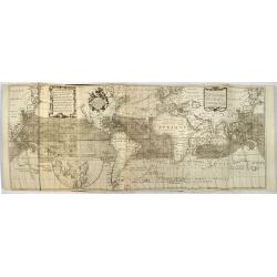
Mappe-Monde dressée sur les observations de M.rs. De L'Academie Royale des Sciences ..
Scarce and early state of the world map published c. 1707, by Delisles with the imprint "Chez l’Auteur sur le Quai de l’Horloge a la Couronne de Diamans, 1700&qu...
Date: Paris, 1707

A new and correct map of the world.
The early eighteenth century was one of the most important periods for English cartography. One of the period's most intriguing world maps is this large-scale map, which ...
Date: London 1714

Le Nouveau et Curieux Atlas Geographique et historique, ou Le Divertissement des Empereurs, Roys, et Princes. Tant dans la Guerre que dans la Paix. Dédié A Son A.R. Monseigneur le Duc d'Orléans Regent du Roîaume de France.
Charming world atlas with double hemisphere world and the North American map feature the Island of California. In Asia and the Pacific, Australia is incompletely mapped a...
Date: Paris, 1719
De Kust van Nova Guinea tot aan deze bogt . . .
De kust van Nova Guinea tot aan deze bogt.De Kust van Nova Guinea ofte Salomon Sweers hoek. Het Landt van Nova Guinea in de Groote Bocht daar wy vergeefs hoopten een doo...
Date: Amsterdam, 1726
Atlas van Zeevaert en Koophandel door de Geheele Weereldt.
Engraved frontispiece, title printed in red and black with engraved vignette, engraved dedication to the Dutch East India Company, 32 double-page engraved charts in very ...
Date: Amsterdam, 1745
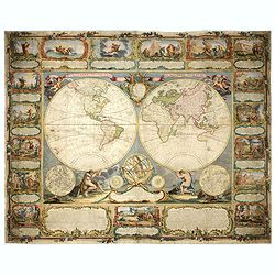
Mappemonde contenant les parties connues du globe terrestre dressée suivant de nouvelles observations
Wall map of the world in two hemispheres printed on two sheets, depicting the Eastern and Western hemispheres supported by two male figures, decorated at the bottom right...
Date: Paris, Longchamps et Janvier, 1754
![Instruments des insulaires de la Mer du Sud. [Tome II Pl. 15.]](/uploads/cache/26097-250x250.jpg)
Instruments des insulaires de la Mer du Sud. [Tome II Pl. 15.]
Divers tools. From the French edition of James Cook's first voyage entitled Relation des voyages entrepris par ordre de sa Majesté Britannique actuellement régnante pou...
Date: Paris, 1773
![Coffre Sculpté des Habitants de la nouvelle Zélande. [Tome III Pl. 13.]](/uploads/cache/26092-250x250.jpg)
Coffre Sculpté des Habitants de la nouvelle Zélande. [Tome III Pl. 13.]
A carved chest of New Zealand, as a specimen of the carving of the country. Engraving drawn after John Frederick Miller (1759-1796). John Frederick Miller was an English ...
Date: Paris, 1773
![Vue de la Rivière d'Endeavour sur la Côte de la Nouvelle Hollande ou le Vaisseau fut mis à la bande. [Tome IV Pl. 1ère.]](/uploads/cache/26093-250x250.jpg)
Vue de la Rivière d'Endeavour sur la Côte de la Nouvelle Hollande ou le Vaisseau fut mis à la bande. [Tome IV Pl. 1ère.]
The first known landscape drawing of the east coast of Australia. A View of the Endeavour River, on the coast of New Holland, where the ship was laid on shore, in order t...
Date: Paris, 1773
![Manière dont on expose les morts à Otahiti. [Tome II Pl. 16.]](/uploads/cache/26113-250x250.jpg)
Manière dont on expose les morts à Otahiti. [Tome II Pl. 16.]
A view of a Tahitian funeral home in a beautiful landscape. Engraved by Demouchy. From the French edition of James Cook's first voyage entitled Relation des voyages entre...
Date: Paris, 1773
![Vue d'un Rocher troué de la Nouvelle Zélande. [Tome III Pl. 8.]](/uploads/cache/26112-250x250.jpg)
Vue d'un Rocher troué de la Nouvelle Zélande. [Tome III Pl. 8.]
A view of a New Zealand landscape and seascape through a hollow rock. Engraved by Demouchy. From the French edition of James Cook's first voyage entitled Relation des voy...
Date: Paris, 1773
![Vue de l'Isle d'Huaheine avec La Maison de Dieu, et un petit Autel couvert d'offrandes. [Tome III Pl. 4.]](/uploads/cache/26108-250x250.jpg)
Vue de l'Isle d'Huaheine avec La Maison de Dieu, et un petit Autel couvert d'offrandes. [Tome III Pl. 4.]
A view of the Island of Huaheine, Tahiti, a beautiful tropical Owharra tree in the foreground and a depiction of the House of God with its offertory. From the French edit...
Date: Paris, 1773
![Vue de l'Isle d'Ulietéa avec une double Pirogue et un hangar où les Insulaires retirent leurs bâtiments de mer. [Tome III Pl. 5.]](/uploads/cache/26106-250x250.jpg)
Vue de l'Isle d'Ulietéa avec une double Pirogue et un hangar où les Insulaires retirent leurs bâtiments de mer. [Tome III Pl. 5.]
A view on the Island of Ulietea, French Polynesia, of a dugout boat house and a beautifully engraved pirogue at sea. From the French edition of James Cook's first voyage ...
Date: Paris, 1773
![Vue de l'Isle d'Otahiti et de plusieurs Pirogues. [Tome II Pl. 11.]](/uploads/cache/26102-250x250.jpg)
Vue de l'Isle d'Otahiti et de plusieurs Pirogues. [Tome II Pl. 11.]
View of the Island of Tahiti and dugouts. From the French edition of James Cook's first voyage entitled Relation des voyages entrepris par ordre de sa Majesté Britanniqu...
Date: Paris, 1773
![Emouchoir des Otahitiens avec ses manches. [Tome II Pl. 13.]](/uploads/cache/26098-250x250.jpg)
Emouchoir des Otahitiens avec ses manches. [Tome II Pl. 13.]
The print depicts three ceremonial fly-whisks from Tahiti. Each object features ornate carved handles with anthropomorphic figures and long flowing fibers, accompanied by...
Date: Paris, 1773
![Hausse-col militaire des insulaires de la Mer du Sud. [Tome II Pl. 12.]](/uploads/cache/26095-250x250.jpg)
Hausse-col militaire des insulaires de la Mer du Sud. [Tome II Pl. 12.]
Maori warrior rise-collar. From the French edition of James Cook's first voyage entitled Relation des voyages entrepris par ordre de sa Majesté Britannique actuellement ...
Date: Paris, 1773
![[HAWAII] - Plan de la baye de Karakakooa.](/uploads/cache/48173-250x250.jpg)
[HAWAII] - Plan de la baye de Karakakooa.
Beautiful map showing the islands forming the Hawaiian archipelago, drawn up during Cook's third voyage: Oneeheow or Ni'ihau, Atooi or Kauai, Woahoo or O'ahu, Morotoi or ...
Date: Paris, 1774
![Cession de l'Isle d'Ohahiti au Capitaine Wallis par la Reine Obéréa. [Tome II Pl. 2.]](/uploads/cache/26111-250x250.jpg)
Cession de l'Isle d'Ohahiti au Capitaine Wallis par la Reine Obéréa. [Tome II Pl. 2.]
Queen Oberea's transfer ceremony to Captain Wallis on Tahiti.Engraved by François Godefroi. From the French edition of James Cook's first voyage entitled Relation des vo...
Date: Paris, 1774
![Village fortifié bâti sur un Rocher troué de la Nouvelle Zélande. [Tome III Pl. 10.]](/uploads/cache/26110-250x250.jpg)
Village fortifié bâti sur un Rocher troué de la Nouvelle Zélande. [Tome III Pl. 10.]
A view of a village fortified on a hollow rock in New Zealand. Engraved by François Godefroi. From the French edition of James Cook's first voyage entitled Relation des ...
Date: Paris, 1774
![[Haida Gwaii,] Baye Swallow . . . / Havre Byron /Côté septentrional de la plus grande des Isles de la Reine Charlotte. . . .](/uploads/cache/25888-250x250.jpg)
[Haida Gwaii,] Baye Swallow . . . / Havre Byron /Côté septentrional de la plus grande des Isles de la Reine Charlotte. . . .
Map of Swallow's Bay and a coastline profile of the Queen Charlotte Islands and Captain Byron's Heaven.Queen Charlotte Islands, with their modern name Haida Gwaii, is an ...
Date: Paris, 1774

A chart of the China Sea inscribed to Monsr. D'APRES de MANNEVILLETTE .. To A.Dalrymple.
This most important milestone chart is based upon the surveys made from navigational surveys by Alexander Dalrymple (1737-1808]. He was the first hydrographer of the Brit...
Date: Paris, ca 1775

A new & accurate map of Asia, Drawn from the most approved modern maps & charts / by Thos. Bowen.
The map is of interest for the use of Sea of Korea, the sea between Korea and Japan.Detailed map of Asia from Saudi Arabia, Persia, Russia, India, China, Japan to Southea...
Date: London, J.Cooke, 1777-1778
Selling price: ????
Please login to see price!
Sold in 2023
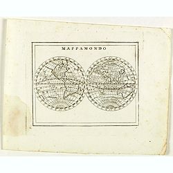
Mappamondo.
Rare world map from "Atlante Novissimo ad uso Dei Giovani Studiosi Contenuto In Carte XXVII.", published by Giovanni Zempel in Rome, ca. 1780.The map is based o...
Date: Rome, 1780

Nouvelle Mappa Monde.
State 2 of this fine double hemisphere world map, from an unusual perspective, with a "Mer de L'Ouest" or "Sea of the West". Paris is located at the c...
Date: Venice, 1776 - 1784
Atlas in elephant folio.
Most of D'Anville's atlases were made up for the individual customer, so no two appear alike. Many of the 59 pages are multi-sheet maps, so the actual map sheet count is ...
Date: Paris, 1771-1786
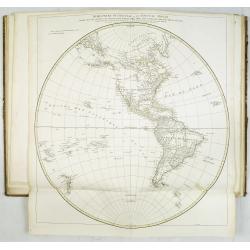
Mappemonde ou carte générale du globe terrestre dessinée suivant les règles de la projection des cartes réduites…
Large world map showing the sea tracks of Captain Cook in his three Pacific voyages published by C. F. Delamarche.Rare state 4, dated 1786, of this large world map, featu...
Date: Paris, Robert de Vaugondy/Delamarche, 1786
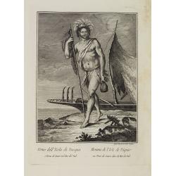
Uomo dell' Isola di Pasqua o Terra di Davis nel Mar del Sud. / Homme de l' Isle de Pâquesou Terra de Davis dans la Mer du Sud.
Full portrait of a native from Easter Island. Easter Island, a Chilean territory, is a remote volcanic island in Polynesia.From "Raccolta di stampe," a series o...
Date: Venice, Antonio Zatta, c.1790
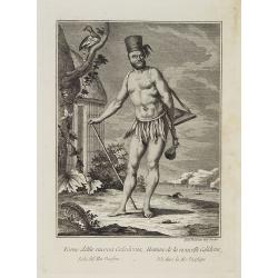
Uomo della nuova Caledonia Isola del Mar Pacifico. / Homme de la nouvelle Calédonie Isle dans la Mer Pacifique.
Full portrait of a native from New Caledonia. A rare engraving from "Raccolata di stampe ... di varie nazioni". From the original drawing by William Hodges, who...
Date: Venice, Antonio Zatta, c.1790
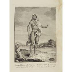
Donna dell' Isola di S.a Cristina una delle Marchesi nel Mar del Sud. / Femme de l' Isle de S.e Christine une des Marquises dans la Mer du Sud.
Full portrait of a woman from the Saint Christina Island. A rare engraving from "Raccolata di stampe ... di varie nazioni". From the original drawing by Willia...
Date: Venice, Antonio Zatta, c.1790
Donna dell' Isola di Pasqua, o terra di Davis nel Mar del Sud. / Femme de l' Isle de Pâques ou terre de Davis dans la Mer du Sud.
Full portrait of a woman, a native of Easter Island, a Chilean territory, is a remote volcanic island in PolynesiaFrom "Raccolta di stampe." a series of histori...
Date: Venice, Antonio Zatta, c.1790
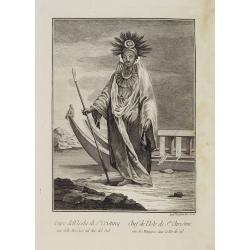
Capo dell' Isola di S.a Cristina una delle Marchesi nel Mar Pacifico del Sud. / Chef de l'Isle de Ste. Christine une des Marquises dans la Mer Pacifique du Sud.
Full portrait of the Chief of the Saint Christina Island. A rare engraving from "Raccolata di stampe ... di varie nazioni". From the original drawing by William...
Date: Venice, Antonio Zatta, c.1790
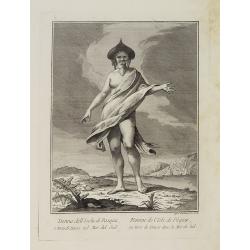
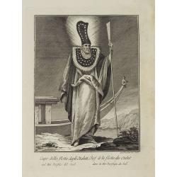
Otoo, Re di Tahiti Isola nel Mar Pacifico del Sud. / Otoo, Roi de Tahiti Isle dans la Mer Pacifique du Sud.
Full portrait of King Otoo from Tahiti. A rare engraving from "Raccolata di stampe ... di varie nazioni". From the original drawing by William Hodges, who acco...
Date: Venice, Antonio Zatta, c.1790
![Otago Capo dell'Isola d'Amsterdam nel Mare Pacifico del Sud. / Otago Chef de l'Isle d'Amsterdam dans la Mer Pacifique du Sud. .. [Tongatapu, Tonga]](/uploads/cache/26090-250x250.jpg)
Otago Capo dell'Isola d'Amsterdam nel Mare Pacifico del Sud. / Otago Chef de l'Isle d'Amsterdam dans la Mer Pacifique du Sud. .. [Tongatapu, Tonga]
Otago was a native of the island of Tongatapu, Tonga. The island was first sighted by Europeans in 1643 by Abel Tasman, commanding two ships. “Tasman named the island &...
Date: Venice, Antonio Zatta, c.1790
![Donna dell' Isola d' Erramanga una delle nuove Ebridi nel Mar Pacifico. / Femme de l'Isle d'Erramanga une des nouvelles Hebrides dans la Mer Pacifique. [Vanuatu]](/uploads/cache/26396-250x250.jpg)
Donna dell' Isola d' Erramanga una delle nuove Ebridi nel Mar Pacifico. / Femme de l'Isle d'Erramanga une des nouvelles Hebrides dans la Mer Pacifique. [Vanuatu]
Full portrait of a woman, native of the island of Erramanga in the New Hebrides, officially the New Hebrides Condominium, the colonial name for the island group in the So...
Date: Venice, Antonio Zatta, c.1790
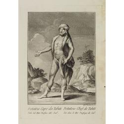
Potatow Capo dei Tahiti Isola nel Mare Pacifico del Sud. / Potatow Chef de Tahiti Isle dans la Mer Pacifique du Sud.
Full portrait of the Hawaiian chief Potatow. A rare engraving from "Raccolata di stampe ... di varie nazioni". From the original drawing by William Hodges, w...
Date: Venice, Antonio Zatta, c.1790
![Donna dell' Isola di Mallicolo una delle nuove Ebridi nel Mar Pacifico del Sud. / Femme de l' Isle d'Erramanga... [Vanuatu]](/uploads/cache/26397-250x250.jpg)
Donna dell' Isola di Mallicolo una delle nuove Ebridi nel Mar Pacifico del Sud. / Femme de l' Isle d'Erramanga... [Vanuatu]
Full portrait of a woman, a native of the island of Mallico in the New Hebrides, officially the New Hebrides Condominium, the colonial name for the island group in the So...
Date: Venice, Antonio Zatta, c.1790
![Donna dell' Isola di Tanna, una delle nuove Ebridi nel Mar Pacifico. / Femme de l' Isle de Tanna, une des nouvelles Hebrides dans la Mer Pacifique. [Vanuatu]](/uploads/cache/26398-250x250.jpg)
Donna dell' Isola di Tanna, una delle nuove Ebridi nel Mar Pacifico. / Femme de l' Isle de Tanna, une des nouvelles Hebrides dans la Mer Pacifique. [Vanuatu]
Full portrait of a woman, a native from the island of Mallico in the New Hebrides, officially the New Hebrides Condominium, the colonial name for the island group in the ...
Date: Venice, Antonio Zatta, c.1790
![Uomo dell' Isola di Tanna, una delle nuove Ebridi nel Mar Pacifico. / Homme de l' Isle de Tanna, une des nouvelles Hébrides dans la Mer du Pacifique. [Vanuatu]](/uploads/cache/26399-250x250.jpg)
Uomo dell' Isola di Tanna, una delle nuove Ebridi nel Mar Pacifico. / Homme de l' Isle de Tanna, une des nouvelles Hébrides dans la Mer du Pacifique. [Vanuatu]
Full portrait of a man from the island of Tanna in the Pacific. New Hebrides, officially the New Hebrides Condominium was the colonial name for the island group in the So...
Date: Venice, Antonio Zatta, c.1790
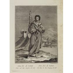
Capo della flotta degli Otahiti nel Mar Pacifico del Sud. / Chef de la flotte des Otahiti dans la Mer Pacifique du Sud.
Full portrait of the captain of the Otahiti flotilla, from Tahiti. A rare engraving from "Raccolata di stampe ... di varie nazioni". From the original drawing...
Date: Venice, Antonio Zatta, c.1790
![Le Isole di Sandwich delineate sulle osservazioni del Cap Cook. [Hawaii]](/uploads/cache/43195-250x250.jpg)
Le Isole di Sandwich delineate sulle osservazioni del Cap Cook. [Hawaii]
FIRST EDITION on laid paper. Cassini’s splendid map depicts the Sandwich Islands, the old name for the Hawaiian Islands, at the end of the eighteenth century. The splen...
Date: Rome, 1798

La nuova Zelanda delineate sulle ultima osservazioni del Capitan Cook.
First edition on laid paper Cassini’s splendid early map of New Zealand, being the most decorative version of Captain Cook's map of New Zealand, published in the very s...
Date: Rome, 1798

La Nuova Olanda e La Nuova Guinea delineate sulle ultima osservazioni.
Cassini’s splendid and rare map of Australia and New Guinea, from the 'Nuovo Atlante Geografico Universale'. The emphasis of the map is the charting of Captain Cook dow...
Date: Rome, 1798

Botanibay, Englischer Verweisungs Ort fur Verbrecher. / Laijene Franzosicher Verweisungs Ort fur Verbrecher.
Copper engraving with four scenes and one portrait of Frederick III of Saxony on one sheet. In the upper part fanciful views of Botany Bay with English and French settlem...
Date: Zittau, 1798-1800

Kaart Van Nieuw Zeeland in de Jaaren 1769 en 1770 bezogt door den Luitenant J. Cook met het Schip De Endeavour.
A uncommon issue of this key map of New Zealand from the Dutch edition of Cook's map of New Zealand, published in 'Reize rondom de Waereld door James Cook', a Dutch editi...
Date: Leyden, Amsterdam & The Hague: Honcoop, Allart & van Cleef, 1795-1801

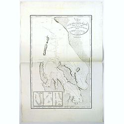
Carte de L'Archipel de La Recherche a la partie Occidentale de la Terre de Nuyts. . .
A large and detailed chart of the southern West Australian coast centered on the region of Esperance and the surrounding islands.Terre de Nuyts is the name that was forme...
Date: Paris 1807

Plan de la Baie de L'Adventure. . .
A French maritime chart of Adventure Bay in S.E. Tasmania. Adventure Bay is the name of both a township and a geographical feature on the eastern side of Bruny Island. Th...
Date: Paris, ca 1807

Plan de L'Isle de Paque / Plan de la Baie de Cook.
Two engraved maps and four coastal profiles of Easter Island in the Pacific. First published in the Atlas du Voyage de la Perouse. This is the edition of the extremely ra...
Date: Paris, 1797-1807
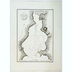
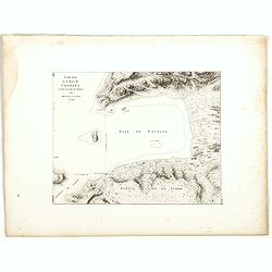
Carte de la Baie des Chiens-Marins (Shark's Bay de Dampier). . .
A strikingly detailed chart of a portion of the coastline of Western Australia, titled 'Carte de la Baie des Chiens-Marins, which William Dampier also explored. The chart...
Date: Paris, 1807

Plan du Port du Sud de la Baie de la Recherche / Croquis de la Baie des Moules. . .
A French maritime chart of the Port du Sud in Research Bay and the mouth of the Bay of Mussels, both in southern Tasmania. This is the edition of the extremely rare atlas...
Date: Paris, ca 1807
Plan du Port du Nord de la Baie de la Recherche.
A French maritime chart of the plan of the northern portion of Recherche Bay on the S.E. tip of Tasmania. The chart has some physical detail, outlining trees and hills, b...
Date: Paris, ca 1807
Plan du Port Jackson / Plan du Comte de Cumberland.
Two maps on one sheet showing the earliest scientific surveys of Port Jackson and the area surrounding Sydney Harbour, undertaken by the French in 1802. This is the editi...
Date: Paris, 1807
![Boats of the Friendly Islands. [together with] A Sailing Canoe of Otaheite.](/uploads/cache/30041-250x250.jpg)
Boats of the Friendly Islands. [together with] A Sailing Canoe of Otaheite.
Early view of Queen charlotte's sound, taken from "Views in the South Seas" being a very important and early views depicting scenes encountered while employed a...
Date: London, Boydell and Co., 1808

View of the harbour of Taloo, in the island of Eimeo.
John Webber View of the Harbour of Taloo on Moorea (Society Islands), from "Views in the South Seas" being a very important and early views depicting scenes enc...
Date: London, Boydell and Co., 1808
![A Toopapaoo of a Chief, with a priest making his offering to the Morai, in Huoheine. [Huaheine - the Society Islands]](/uploads/cache/30045-250x250.jpg)
A Toopapaoo of a Chief, with a priest making his offering to the Morai, in Huoheine. [Huaheine - the Society Islands]
A view of a chief's raised burial chamber in Huaheine, Society Islands, taken from "Views in the South Seas" being a very important and early view depicting sce...
Date: London, Boydell and Co., 1808
Esquisse de la Baie de Coupang (cote S.O. Ile de Timor) par M. M. Peron et Lesueur, an 1803.
Map of Kupang Bay on the Indonesian Island Timor, prepared by Louis Freycinet during his voyage under Captain Thomas Baudin in 1800-1803. Plate no. 14 from the atlas part...
Date: Paris, Langois, 1811
![[Title page] Voyage de découvertes aux terres Australes éxécuté par ordre de S.M l'Empereur et Roi.](/uploads/cache/39732-250x250.jpg)
[Title page] Voyage de découvertes aux terres Australes éxécuté par ordre de S.M l'Empereur et Roi.
Set of two title pages from the atlas part of "Voyage de decouvertes aux terres australes", Freycinet and Peron's accounts of the French cartographic expedition...
Date: Paris, Langois, 1811
![[Title page] Voyage de découvertes aux terres Australes . . . Deuxieme partie.](/uploads/cache/46363-250x250.jpg)
[Title page] Voyage de découvertes aux terres Australes . . . Deuxieme partie.
Title page of the atlas Voyage de découvertes aux terres Australes by François Péron, 1824. The French expedition under Nicolas Baudin, was commissioned to chart the c...
Date: Paris, 1807-1816
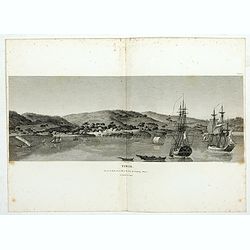
Timor. Vue de la rade, de la ville et du fort de Coupang, dans l'île de Timor.
Nice double page view of the town Kupang, formerly known as Koepang. In the center is the Dutch V.O.C. fort. From Voyage de découvertes aux terres Australes by François...
Date: Paris, 1807-1816
![Timor. Canda Jeune fille Malaise. [plate XXVI]](/uploads/cache/46348-250x250.jpg)
Timor. Canda Jeune fille Malaise. [plate XXVI]
A portrait of a female Canda by Lesueur, from Voyage de découvertes aux terres Australes by François Péron, 1824.The French expedition under Nicolas Baudin, was commis...
Date: Paris, 1824
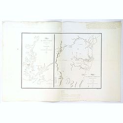
![Plan de la partie sud des Iles Furneaux [with] Carte générale de la Partie Sud-Est de la Terre de Diémen . . .](/uploads/cache/46365-250x250.jpg)
Plan de la partie sud des Iles Furneaux [with] Carte générale de la Partie Sud-Est de la Terre de Diémen . . .
Two maps on one sheet, on top a map of the southern portion of Cape Barren Island, Clarke Island, and islets in the southern part of the Furneaux Group.With in lower part...
Date: Paris, 1824
![Timor. Naba-Leba Roi de L'Ile Solor. [plate XXV]](/uploads/cache/46347-250x250.jpg)
Timor. Naba-Leba Roi de L'Ile Solor. [plate XXV]
A portrait of a male Naba-Leba by Lesueur, from Voyage de découvertes aux terres Australes by François Péron, 1824.The French expedition under Nicolas Baudin, was comm...
Date: Paris, 1824
![Terre de Diemen. Grou-Agara. [plate X]](/uploads/cache/46273-250x250.jpg)
Terre de Diemen. Grou-Agara. [plate X]
A portrait of the Tasmanian Aboriginal Grou-Agara, after the original sketches by Lesueur, from Voyage de découvertes aux terres Australes by François Péron, 1824.The ...
Date: Paris, 1824
Selling price: ????
Please login to see price!
Sold in 2024
![Terre de Diemen. Arra-Maida. [plate XII]](/uploads/cache/46275-250x250.jpg)
Terre de Diemen. Arra-Maida. [plate XII]
A portrait of a female Tasmanian Aboriginal Arra-Maida, after the original sketches by Lesueur, from Voyage de découvertes aux terres Australes by François Péron, 1824...
Date: Paris, 1824
Selling price: ????
Please login to see price!
Sold in 2024
![Terre de Diemen. Habitations. [plate XV].](/uploads/cache/46278-250x250.jpg)
Terre de Diemen. Habitations. [plate XV].
An aboriginal camp fire, near the ruins of an old wooden fence, and a dead tree, after the original sketches by Lesueur, from Voyage de découvertes aux terres Australes ...
Date: Paris, 1824
![Nouvelle-Hollande: Nelle. Galles du sud - Navigation. [plate XXIII]](/uploads/cache/46345-250x250.jpg)
Nouvelle-Hollande: Nelle. Galles du sud - Navigation. [plate XXIII]
An aboriginal camp fire, with a pirogue and two men navigating , after the original sketches by Lesueur, from Voyage de découvertes aux terres Australes by François Pé...
Date: Paris, 1824
![Nouvelle-Hollande: Terre dEndracht - Cabane des naturels de la Presqu'Ile de Péron. [plate XXIV]](/uploads/cache/46346-250x250.jpg)
Nouvelle-Hollande: Terre dEndracht - Cabane des naturels de la Presqu'Ile de Péron. [plate XXIV]
An aboriginal camp fire, after the original sketches by Lesueur, from Voyage de découvertes aux terres Australes by François Péron, 1824.The French expedition under Ni...
Date: Paris, 1824
