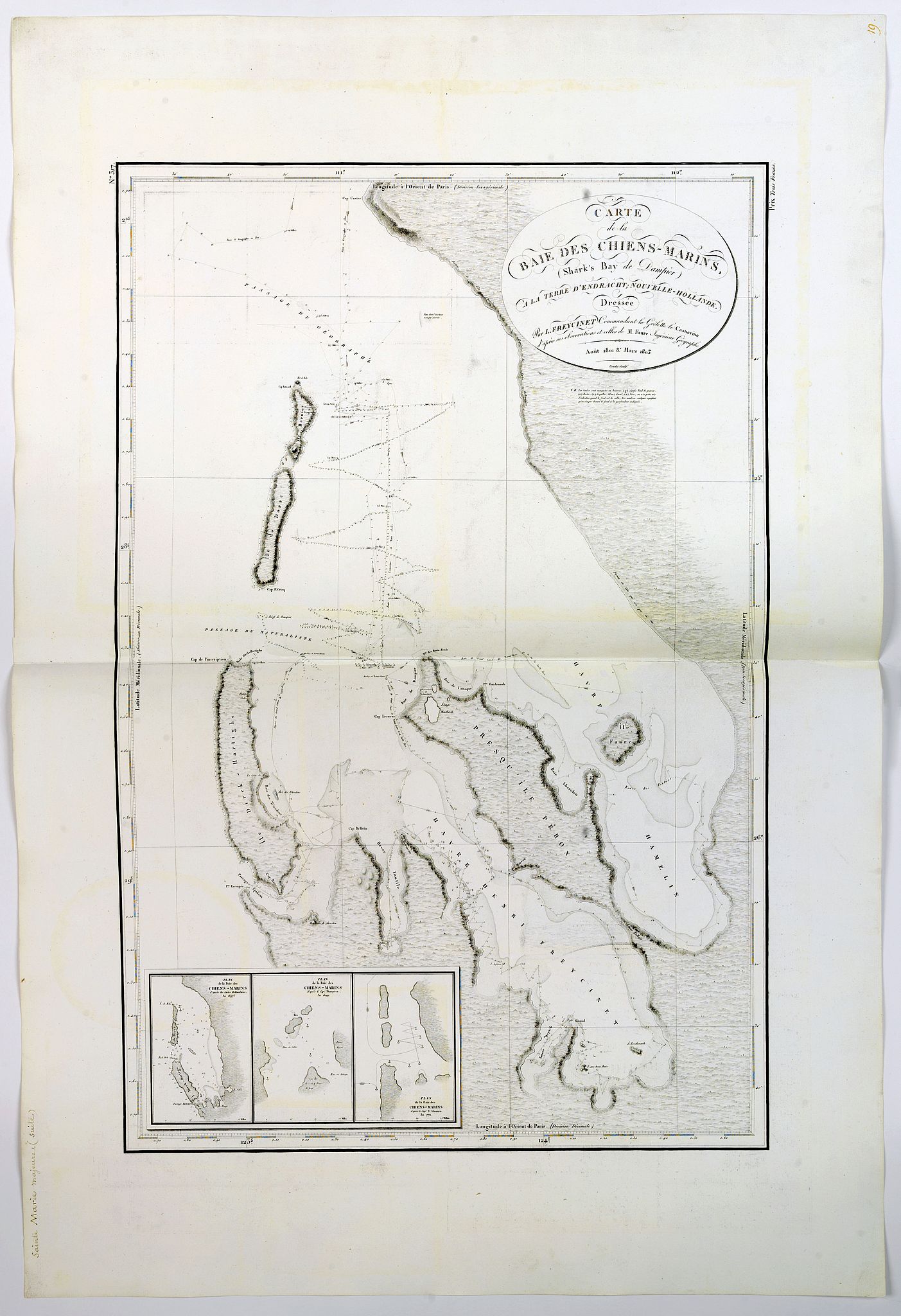
Carte de la Baie des Chiens-Marins (Shark's Bay de Dampier). . . |
||||||||||||||||||||
|
||||||||||||||||||||
|
|
||||||||||||||||||||
$2500 / ≈ €2194This item is available for immediate sale! Questions before Buying ?
We are happy to answer your questions.
2500.00
|
My Collection +
Add this or any of your favorite items in one place. If you want to save the items permanently, you have to sign in or create an account first. |
|||||||||||||||||||
Description
A strikingly detailed chart of a portion of the coastline of Western Australia, titled 'Carte de la Baie des Chiens-Marins, which William Dampier also explored.
The chart is more commonly known from its appearance in "Navigation et Geographie’ part of the Peron / Freycinet atlas, published by Freycinet in 1812. This is the edition of the extremely rare atlas Neptune des côtes orientales et du grand archipel d'Asie, published in 1807. The atlas was a supplement to the atlas series published by the Hydrographic Office and prepared by C.F. Beautemps-Beaupré, who is now regarded as the father of modern French hydrography.
The map is more commonly known from its appearance in the atlas which accompanied the Atlas volume (volume 3) of Freycinet's 'Voyage de découvertes aux terres Australes . . .'. However, the maps for the Neptune edition are printed on very thick and larger paper. The usual text in the upper right corner is not there, but instead "N°. 317" is engraved, and instead of Bouclet's name, the words "Prix Deux Francs" are at the bottom.
Very rare.
A later edition bears the stamp of the Hydrographic Office.
Very rare.
This is the first thorough survey of the bay, which is marked not only by Dampier's time there, but also by the other Dutch ships that touched there.
In the lower left corner is an inset showing three historical renderings of the 'Baie des Chiens-Marins'. The first, to the left, is from a Dutch chart of 1697. To the left is a chart from 1772.
The Dutch had touched on the west coast of Australia throughout the seventeenth century, but they were unable to chart large swathes of the coast with any great accuracy. The middle inset is from Dampier's visit to the area in 1699. The coastline of Western Australia is largely based on early Dutch discoveries, including ships that were stranded, shipwrecked, and blown off course.
Shark Bay is a World Heritage Site in the Gascoyne region of Western Australia, and is located approximately 800 kilometres north of Perth, on the westernmost point of the Australian continent.
More about C.F. Beautemps-Beaupré and mapping of Australia." [+]
Reference: Tooley, The mapping of Australia and Antartica, 646, pag. 87. (only for common Freycinet version)
FAQ - Guarantee - Shipping
Buying in the BuyNow Gallery
This item is available for immediate purchase when a "Add to Cart" or "Inquire Now" button is shown.
Items are sold in the EU margin scheme
Payments are accepted in Euros or US Dollars.
Authenticity Guarantee
 We provide professional descriptions, condition report (based on 45 years experience in the map business)
Paulus Swaen warrants the authenticity of our items and a certificate of authenticity is provided for each acquired lot.
Condition and Coloring
We indicate the condition of each item and use our unnique HiBCoR grading system in which four key items determine a map's value: Historical Importance, Beauty, Condition/Coloring and Rarity.
Color Key
We offer many maps in their original black and white condition. We do not systematically color-up maps to make them more sellable to the general public or buyer.
Copper engraved or wood block maps are always hand colored. Maps were initially colored for aesthetic reasons and to improve readability. Nowadays, it is becoming a challenge to find maps in their original colors and are therefor more valuable.
We use the following color keys in our catalog:
Original colors; mean that the colors have been applied around the time the map was issued.
Original o/l colors; means the map has only the borders colored at the time of publication.
Colored; If the colors are applied recently or at the end of the 20th century.
Read more about coloring of maps [+]
Shipping fee
A flat shipping fee of $ 30 is added to each shipment by DHL within Europe and North America. This covers : International Priority shipping, Packing and Insurance (up to the invoice amount).
Shipments to Asia are $ 40 and rest of the world $50
We charge only one shipping fee when you have been successful on multiple items or when you want to combine gallery and auction purchases.
Read more about invoicing and shipping
FAQ
Please have a look for more information about buying in the BuyNow gallery
Many answers are likely to find in the general help section.
My Collection+
![]()
With My Collection+ you can collect all your favorite items in one place. It is free, and anyone can create his or her virtual collection.
Unless you are logged in, the item is only saved for this session. You have to be registed and logged-in if you want to save this item permanently to My Collection+.
Read More[+]
Register here, it is free and you do not need a credit card.
Add this item to
My Collection+
or click the following link to see My Collection+.
| Digital Image Download | |
|
Paulus Swaen maintains an archive of most of our high-resolution rare maps, prints, posters and medieval manuscript scans. We make them freely available for download and study. Read more about free image download |
Click the image for a free small image download. |
In accordance with the EU Consumer Rights Directive and habitually reside in the European Union you have the right to cancel the contract for the purchase of a lot, without giving any reason.
The cancellation period will expire 14 calendar days from the day after the date on which you or a third party (other than the carrier and indicated by you) acquires, physical possession of the lot. To exercise the right to cancel you must inform Paulus Swaen Inc, of your decision to cancel this contract by a clear statement (e.g. a letter sent by post, or e-mail.
To meet the cancellation deadline, it is sufficient for you to send your communication concerning your exercise of the right to cancel before the cancellation period has expired.
