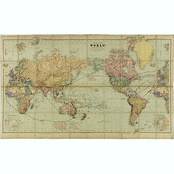
Search Listings matching "australia"
![Timor. Naba-Leba Roi de L'Ile Solor. [plate XXV]](/uploads/cache/46347-250x250.jpg)
Timor. Naba-Leba Roi de L'Ile Solor. [plate XXV]
A portrait of a male Naba-Leba by Lesueur, from Voyage de découvertes aux terres Australes by François Péron, 1824.The French expedition under Nicolas Baudin, was comm...
Date: Paris, 1824
![Timor. Canda Jeune fille Malaise. [plate XXVI]](/uploads/cache/46348-250x250.jpg)
Timor. Canda Jeune fille Malaise. [plate XXVI]
A portrait of a female Canda by Lesueur, from Voyage de découvertes aux terres Australes by François Péron, 1824.The French expedition under Nicolas Baudin, was commis...
Date: Paris, 1824
![Nouvelle-Hollande: Ile King. - L'Eléphant -marin ou Phoque à trompe. [plate XXXII]](/uploads/cache/46354-250x250.jpg)
Nouvelle-Hollande: Ile King. - L'Eléphant -marin ou Phoque à trompe. [plate XXXII]
Plate illustrating seals by Lesueur, from Voyage de découvertes aux terres Australes by François Péron, 1824.The French expedition under Nicolas Baudin, was commission...
Date: Paris, 1824
![Timor. Rhinolophe Cruménifére. [plate XXXV]](/uploads/cache/46357-250x250.jpg)
Timor. Rhinolophe Cruménifére. [plate XXXV]
Plate illustrating Horseshoe bats from Timor Island, by Lesueur, from Voyage de découvertes aux terres Australes by François Péron, 1824.The French expedition under Ni...
Date: Paris, 1824
![Nouvelle-Hollande Nelle Galles du sud. Vue d'une partie de la ville de Sydney capitale des Colonies Anglaises aux Terres Australes . . . [plate XXXVII]](/uploads/cache/46359-250x250.jpg)
Nouvelle-Hollande Nelle Galles du sud. Vue d'une partie de la ville de Sydney capitale des Colonies Anglaises aux Terres Australes . . . [plate XXXVII]
An important view of Sydney Cove from Dawes Point looking eastward from Voyage de découvertes aux terres Australes by François Péron, 1824. This is one of the earliest...
Date: Paris, 1824
![Plan de la partie sud des Iles Furneaux [with] Carte générale de la Partie Sud-Est de la Terre de Diémen . . .](/uploads/cache/46365-250x250.jpg)
Plan de la partie sud des Iles Furneaux [with] Carte générale de la Partie Sud-Est de la Terre de Diémen . . .
Two maps on one sheet, on top a map of the southern portion of Cape Barren Island, Clarke Island, and islets in the southern part of the Furneaux Group.With in lower part...
Date: Paris, 1824
![[Papua New Guinea Inhabitants ].](/uploads/cache/26364-250x250.jpg)
[Papua New Guinea Inhabitants ].
Aquatint depicts three men in a pirogue engraved by Fumagalli. Plate N° 75. From Giulio Ferrario's work Le Costume Ancien et Moderne ou Histoire du gouvernement, de la m...
Date: Milan, 1827
![[The Admiralty Islands and New Britain inhabitants fishing. Papua New Guinea ].](/uploads/cache/26365-250x250.jpg)
[The Admiralty Islands and New Britain inhabitants fishing. Papua New Guinea ].
Aquatint depicting fishermen in dugouts engraved by A. Biasioli. Plate N° 14. From Giulio Ferrario's work Le Costume Ancien et Moderne ou Histoire du gouvernement, de la...
Date: Milan, 1827
![[ Traditional tools from New Caledonia ].](/uploads/cache/26366-250x250.jpg)
[ Traditional tools from New Caledonia ].
Aquatint depicting a variety of traditional tools from New Caledonia engraved by Rossi. Plate N° 72. From Giulio Ferrario's work Le Costume Ancien et Moderne ou Histoi...
Date: Milan, 1827
![[New Caledonians ].](/uploads/cache/26367-250x250.jpg)
[New Caledonians ].
Aquatint depicting New Caledonians engraved by Biasioli. Plate N° 71. From Giulio Ferrario's work Le Costume Ancien et Moderne ou Histoire du gouvernement, de la milice,...
Date: Milan, 1827
![[Pirogues in the bay of the voyage of the Resolution. The Marquesas Islands ].](/uploads/cache/26373-250x250.jpg)
[Pirogues in the bay of the voyage of the Resolution. The Marquesas Islands ].
Aquatint depicting men in pirogues in the Bay of the Resolution from the Marquesas Islands engraved by Biasioli. Plate N° 91. From Giulio Ferrario's work Le Costume Anci...
Date: Milan, 1827
![[Marquesas Islands headdresses and head ornaments ].](/uploads/cache/26374-250x250.jpg)
[Marquesas Islands headdresses and head ornaments ].
Aquatint depicting Marquesas Islanders in traditional headdresses and a variety of head ornaments engraved by Bonatti. Plate N° 90. From Giulio Ferrario's work Le Costum...
Date: Milan, 1827
![[Easter Island inhabitants ].](/uploads/cache/26375-250x250.jpg)
[Easter Island inhabitants ].
Aquatint depicting 2 portraits of Easter Island inhabitants and 2 men rowing in a pirogue. Engraved by Carlo Bottigella. Plate N° 88. From Giulio Ferrario's work Le Cost...
Date: Milan, 1827
![[Women dancing in a Ulietea house ].](/uploads/cache/26376-250x250.jpg)
[Women dancing in a Ulietea house ].
Aquatint depicting women dancing in front of musicians and local villagers in a Ulietea house. Plate N° 87. From Giulio Ferrario's work Le Costume Ancien et Moderne ou H...
Date: Milan, 1827
![[Tahitian warrior dugouts ].](/uploads/cache/26377-250x250.jpg)
[Tahitian warrior dugouts ].
Aquatint depicting a view of Tahitian warrior dugouts engraved by Fumagalli. Plate N° 86. From Giulio Ferrario's work Le Costume Ancien et Moderne ou Histoire du gouve...
Date: Milan, 1827
![[Tahitian tools ].](/uploads/cache/26378-250x250.jpg)
[Tahitian tools ].
Aquatint depicting a variety of Tahitian tools engraved by Rivelanti. Plate N° 85. From Giulio Ferrario's work Le Costume Ancien et Moderne ou Histoire du gouvernement...
Date: Milan, 1827
![Mortuary scene. Tahiti Islands ].](/uploads/cache/26380-250x250.jpg)
Mortuary scene. Tahiti Islands ].
This aquatint depicts a mortuary scene in front of a tapapow, a shed under which the dead bodies remains are exposed until they dry. Engraved by Roffi. Plate N° 83. From...
Date: Milan, 1827
![[Queen Obera welcoming Captain Wallis. Tahiti ].](/uploads/cache/26381-250x250.jpg)
[Queen Obera welcoming Captain Wallis. Tahiti ].
Aquatint depicting Queen Obera welcoming Captain Wallis upon his arrival in Tahiti. Engraved by Gallina. Plate N° 82. From Giulio Ferrario's work Le Costume Ancien et Mo...
Date: Milan, 1827
![[The Friendly Islands ].](/uploads/cache/26384-250x250.jpg)
[The Friendly Islands ].
Aquatint depicting seashore scene of the Friendly Islands. These islands are also known as the Friendly Islands because of the friendly reception accorded to Captain Cook...
Date: Milan, 1827
![[Portraits. Friendly Islands ].](/uploads/cache/26385-250x250.jpg)
[Portraits. Friendly Islands ].
Aquatint depicting inhabitants of the Friendly Islands. Plate N°79. From Giulio Ferrario's work Le Costume Ancien et Moderne ou Histoire du gouvernement, de la milice, d...
Date: Milan, 1827
![[Scene of a meeting. The Friendly Islands ].](/uploads/cache/26386-250x250.jpg)
[Scene of a meeting. The Friendly Islands ].
Aquatint depicting an indoor meeting in the Friendly Islands. Plate N°79. From Giulio Ferrario's work Le Costume Ancien et Moderne ou Histoire du gouvernement, de la mil...
Date: Milan, 1827

Carte des Iles Hawaii.
A lovely small map of the complete chain of Pacific islands known today as the Hawaiian islands, from Dumont d'Urville's atlas "Voyage pittoresque autour du Monde.&q...
Date: Paris, 1834
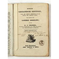
Korte geographische oefeningen voor het eerste onderwijs in de kennis der geheele aarde
Ilustrated with World Map, map of Europe, the Netherlands, Asia, Africa, North America, South America and Australia.Provenance : J.de Veth, October 1845.
Date: Zaltbommel, 1843

Entrée des forêts de la rivière Sedger. . .
Exquisite contemporary colored lithograph of Sedger's river in the Chili, with as seen by Dumont D'Urville's, with Indians. Drawn by Louis Le Breton, lithographed by Bich...
Date: Paris, 1846

Rivage du port Saint-Nicolas.
Exquisite contemporary colored lithograph of Port Saint-Nicolmas Bay in most southern part of South America, with Dumont D'Urville's officers making landfall. Drawn by E....
Date: Paris, 1846

Océanie.
A very decorative 19th century map of the Pacific Ocean, with hand colored lines indicating the extent of Polynesia, Mirconesia, Melanesia, and Malaysia (or Southeast Asi...
Date: Paris, 1850
Selling price: ????
Please login to see price!
Sold in 2025

Océanie.
A very decorative 19th century map of the Pacific Ocean, with hand colored lines indicating the extent of Polynesia, Micronesia, Melanesia, and Malaysia (or Southeast Asi...
Date: Paris, 1850
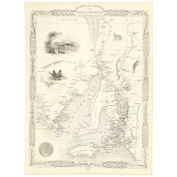
Part of South Australia.
Decorative steel engraved map of part of South Australia, surrounded by illustrations of Adelaide, natives on a catamaran, an Australian dog and a nymphicus bird illustra...
Date: London, ca. 1851
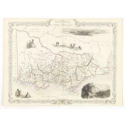
Victoria or Port Phillip.
Decorative steel engraved map of Victoria or Port Phillip, surrounded by illustrations of Melbourne, indigenous people and the Glenelg River. Interlocking border design. ...
Date: London, ca. 1851

Australia.
Decorative steel engraved map of Australia, surrounded by illustrations of Sydney harbor, birds, kangaroos and local people. Interlocking border design. Taken from "...
Date: London, ca. 1851
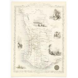
Western Australia. Swan River.
Decorative steel engraved map of part of Western Australia and Swan River, surrounded by illustrations of Perth, Aborigines and sheep shearing. With the seal of Western A...
Date: London, ca. 1851

(The City And Harbour Of Sydney From Near Vaucluse.)
One of the most sought after views of the city and harbour of Sydney seen from Near Vaucluse, 1852. Magnificent hand-colored tinted lithograph and finished by gum-Arabic....
Date: London, J. Hogarth, 1852
![[Collection of six maps of Australia and New Zealand.]](/uploads/cache/48412-250x250.jpg)
[Collection of six maps of Australia and New Zealand.]
Collection of maps including 6 engraved maps by 19th century German, French and English cartographers depicting Australia and New Zealand.This made to order atlas contain...
Date: Germany, 1832-1852
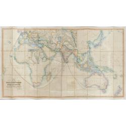
The Pathways of Empire Delineated: Map Showing The Steam Comunication And Overland Routes between England, India, China & Australia…
An illuminating and attractive map that illustrates one of the foundations of British imperial power--the key trade routes by both land and sea between England and its fa...
Date: London, 1856
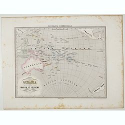
Oceania.
Uncommon map of Pacific ocean prepared by Francesco Costantino Marmocchi. Above the map "Geografia Commerciale". From "Il Globo Atlante di carte Geografich...
Date: Genova, Paolo Rivara fu Giacomo, 1858
Volume III of the monumental atlas, ‘L’Orbe Cattolico ossia Atlante Geografico Storico Ecclesiastico’.
PETRI Girolamo's extremely rare Atlas volume III of the monumental atlas, ‘L’Orbe Cattolico ossia Atlante Geografico Storico Ecclesiastico’, respectively depictin...
Date: Rome, 1858
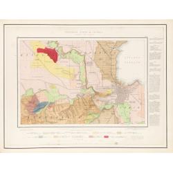
Geological Survey of Victoria.
The portfolio with the gold stamped title "Geological Survey of Victoria", contains 51 sheets maps. There is a pocket attached to the inside front cover contain...
Date: Mining and Geological Department, Melbourne, ca. 1864

North Pacific.
Huge three sheet so-called Blue-back sailing chart of the Northern Pacific including China, Korea (with Matu Is. and Liancourt), Japan, Philippines, Kamchatka, Hawaii, Al...
Date: London, 1868
A Chart of the World on Mercator's Projection Shewing the Principal Ocean Steam Routes, the Submarine Telegraphs &c.
Charming, folding world map on Mercator's projection showing extensive steam routes and underground and undersea telegraph cables. The map is annotated in blue and red wi...
Date: London, ca. 1890

CANTON Kong-Teheou.
Very detailed (1:1.000.000) map centered on Macao and Victoria Island, showing soundings, English, Australian, Danish telegraph lines reaching Hong Kong and extended to M...
Date: Paris, 1898 updated for june 1904
![[Australia and New Zealand map with Ottoman script.]](/uploads/cache/44313-250x250.jpg)
[Australia and New Zealand map with Ottoman script.]
Post card size map in Ottoman script showing Australia and New Zealand prepared by Mehmet EŞREF in a small atlas : عمومولاياةىشهانيىحاوىكوچكا�...
Date: Istanbul, 1325 or 1909
![[Australia, New Zealand and Oceania map with Ottoman script]](/uploads/cache/44319-250x250.jpg)
[Australia, New Zealand and Oceania map with Ottoman script]
Postcard size map in Ottoman script showing Australia, New Zealand and Oceania prepared by Mehmet EŞREF in a small atlas : عمومولاياةىشهانيىحاوىك�...
Date: Istanbul, 1325 or 1909
Canberra Contour Survey.
An important large-scale folding map by Charles Scrivener of the present-day city of Canberra, featuring contour lines and elevation data, created as part of the prelimin...
Date: Department of Lands, Sydney N.S.W. July, 1909

Atlas Geographique. (Puzzle).
Three map puzzles, each measuring 25 x 33 cm., housed in the original color printed card case. Geographical jigsaw puzzle set comprising three maps (world, Europe and Fra...
Date: Paris, ca. 1910
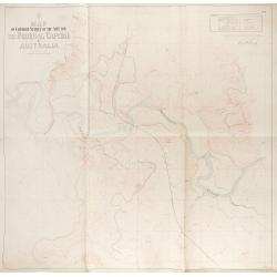
Map of contour survey of the site for the federal capital of Australia.
Map of contour survey of the site for the federal capital of Australia / drawn on stone by Messrs. O. Fischer and A.G. von Stach under direction of E.S. Vautin ; drawn on...
Date: Department of Lands, Sydney, 1910
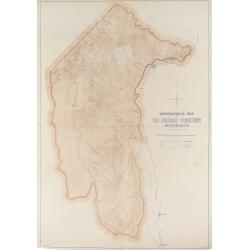
Topographical map of the Federal Territory, Australia.
This map, published by the New South Wales Department of Lands in Sydney in 1910, depicts the Federal Territory—the area designated to house Australia’s future federa...
Date: Sydney, Dept. of Lands, 1910
![[Lot of 2 maps] Map of part of New South Wales Australia shewing position of Commonwealth Territory / Map of New South Wales Australia…](/uploads/cache/49457-250x250.jpg)
[Lot of 2 maps] Map of part of New South Wales Australia shewing position of Commonwealth Territory / Map of New South Wales Australia…
Two maps depicting the region of New South Wales and the area designated as the future Commonwealth Territory (which later became the Australian Capital Territory).The fi...
Date: Department of Lands, Sydney NSW, 1911
![[Lot of Five Pacific Brand crate labels]](/uploads/cache/45706-250x250.jpg)
[Lot of Five Pacific Brand crate labels]
Five fruit crate label for Pacific Brand, showing a lemon and a map of the Pacific Ocean, centered on Hawaii and including a part of California and Asia, with also Austra...
Date: Santa Barbara, 1917
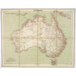
AUSTRALIE
Detailed folding maps of Australia. In upper left corner "Atlas Universal" and in upper right corner "Carte 78".In lower left "Dessiné: le trait...
Date: Paris, ca. 1930
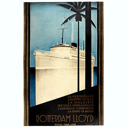
Rotterdam Lloyd, Royal Mail Line. La Méditerranée - L' Egypte - Ceylan - La Malaysie - Les Indes Néerlandaises - L' Australie - L' Indo-Chine - La Chine - Le Japon.
Johann von Stein made this iconic poster for the Rotterdam Lloyd in 1930. This is the rare French version for the tour from Rotterdam to Australia.Johann von Stein (Dutch...
Date: Rotterdam, 1930

Histoire Socialiste.
Text includes “Imp. Centre de Propagande, des Républicains Nationaux, 102, rue Amelot, Paris (XIe), ou l’on peut se procurer cette affiche. Cette affiche ne peut êt...
Date: Paris, 1931
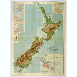
Bartholomew's Touring Map of New Zealand.
A full color map. 'Reduced Survey Map of New Zealand, colored to Show Height of Land'. With insets of Auckland Harbour, Wellington and Port, Christchurch and Port Lyttelt...
Date: Edinburgh, 1935
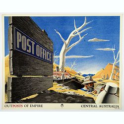
Outposts of Empire. Central Australia.
A large colored lithograph by John Vickery (1906-1983), he was an Australian artist. He worked in the fields of painting, illustration and advertising. He is the only Aus...
Date: London, ca 1937

Outposts of Empire. Ceylon.
A large colored lithograph by John Vickery (1906-1983), he was an Australian artist. He worked in the fields of painting, illustration and advertising. He is the only Aus...
Date: London, ca 1937
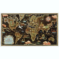
AIR France réseau arérien mondial.
Original lithograph advertising planisphere cardboard from AIR France. The map is designed by Lucien Boucher and is in fact a reduced version of his larger format poster....
Date: Imprimerie Perceval, Paris, 1938
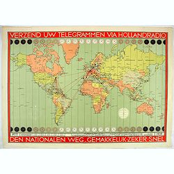
Verzend uw telegrammen via Holland Radio Den Nationalen weg. Gemakkelijk -Zeker - Snel.
Poster showing a world map in Mercator projection. In top and bottom clocks showing the time zones. Red lines connecting The Netherlands with different major hubs in Amer...
Date: The Netherlands, 1939
Hammond's War Map.
Drawn and published in early 1942 by C. S. Hammond & Co. in direct response to the bombing of Pearl Harbour, this is one of the most detailed USA maps of the Pacific ...
Date: New York, 1943
Cycloramic view of Canberra capital site, view looking from Camp Hill / … view looking from Vernon.
Showing an extensive panoramic view of the site of Canberra with various features named. Very large colour photo-mechanical print. Printed by John Sands Ltd [Syd].This 5 ...
Date: Sydney, John Sands, [1911]
![[Set of two maps of the Pacific Ocean with transportation lines, with Ottoman script]](/uploads/cache/44327-250x250.jpg)
[Set of two maps of the Pacific Ocean with transportation lines, with Ottoman script]
Two post card size maps showing the Pacific Ocean with transportation lines. The maps are in Ottoman script prepared by Mehmet EŞREF in a small atlas : عمومولاي...
Date: Istanbul, Şirket-i Mürettibiye ve Karacoğlu Matbaas&#
