Subscribe to be notified if similar examples become available.
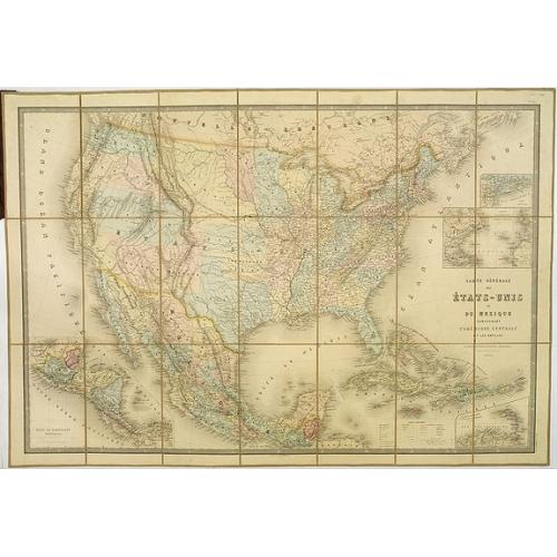
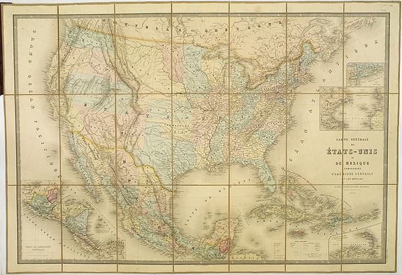
Carte Générale Des Etats - Unis Et Du Mexique Comprenant L'Amerique Centrale Et Les Antilles. |
||||||||||||||||||||
|
||||||||||||||||||||
|
|
||||||||||||||||||||
|
Selling price: $ Please login to see price!
Sold in 2019 Missed this item! Add your name to our mailing list and be the first to get notified about our newly added listings. . |
Collection - Save and collect this or any of your favorite items in one place.
If you want to save the items permanently, please sign in or create account first. |
|||||||||||||||||||
Description
Large folding-map of the United States, Mexico and West Indies, with inset maps of Central America, Lesser Antilles, New York and Long Island, and the Atlantic connections to Europe. Showing the Civil War-era from coast to coast and provides a very up-to-date account of the political boundaries of the West, especially notable for a European map produced during a period when the boundaries changed frequently as a result of the war. The advancing and existing railway lines to the West are of great interest.
One of the most interesting of these changes is the early appearance of "Colona," the first name for Colorado. Colorado Territory was organized in the wake of the 1859 Colorado Gold Rush, which had brought the first large influx of white settlement into the region. Congress passed the organic act for the territory in the spring of 1861 during the thick of the secessions by Southern states that precipitated the Civil War. The organization of Colorado Territory was promoted to solidify Union control over a mineral-rich area of the Rocky Mountains.
Another manifestation of the Civil War boundary struggle is the positioning of a horizontal Arizona in the southern third of a large, horizontal New Mexico Territory. The configuration represents John Baylor?s short-lived Confederate Territory of Arizona, which existed for nearly a year from August 1861 to July 1862.
Union forces arriving in the winter of 1862 from California drove the Confederate troops back to the Rio Grande, foiling the Confederate ploy to gain control of the territory's rich mining resources. Congress created the official Territory of Arizona in February of the next year.
Other western provisional boundaries presented on the map include "Dagotah" Territory lying in the region between Minnesota and the Missouri River, Nebraska covering the rest of the region up to the Rocky Mountains, the huge Utah Territory encompassing present-day Nevada, and a Washington Territory that stretches to the Continental Divide. Oregon has gained statehood, but has lost its eastern lands, which are destined to become the southern portion of Idaho and are here named ?Shoshone? in an unusual configuration below Washington.
The map also details wagon and emigrant roads, topography, Indian settlements, advancing and existing railroads, and all of Mexico, Guatemala, the Caribbean, and Central America. European possessions in the Caribbean are indicated by underlining the names in colors representing France, England, Holland, Denmark, or Spain. This is a fascinating Civil War-period map by a notable French mapmaker in remarkable condition.
Map is dissected into 21 sections and mounted on tan linen with the book plate of Andriveau-Goujon. Covers are dark green cloth 23.5x14.5 with Etats-Unis Et Mexique. Andriveau-Goujon. Rue Du Bac, 2I. stamped in gold on the front with embossed gold and green globe. The spine is stamped with Etats-Unis in gold. Map has full wash color by state.
Reference: Phillips Maps p.910.
FAQ - Guarantee - Shipping
Buying in the BuyNow Gallery
This item is available for immediate purchase when a "Add to Cart" or "Inquire Now" button is shown.
Items are sold in the EU margin scheme
Payments are accepted in Euros or US Dollars.
Authenticity Guarantee
 We provide professional descriptions, condition report (based on 45 years experience in the map business)
Paulus Swaen warrants the authenticity of our items and a certificate of authenticity is provided for each acquired lot.
Condition and Coloring
We indicate the condition of each item and use our unnique HiBCoR grading system in which four key items determine a map's value: Historical Importance, Beauty, Condition/Coloring and Rarity.
Color Key
We offer many maps in their original black and white condition. We do not systematically color-up maps to make them more sellable to the general public or buyer.
Copper engraved or wood block maps are always hand colored. Maps were initially colored for aesthetic reasons and to improve readability. Nowadays, it is becoming a challenge to find maps in their original colors and are therefor more valuable.
We use the following color keys in our catalog:
Original colors; mean that the colors have been applied around the time the map was issued.
Original o/l colors; means the map has only the borders colored at the time of publication.
Colored; If the colors are applied recently or at the end of the 20th century.
Read more about coloring of maps [+]
Shipping fee
A flat shipping fee of $ 30 is added to each shipment by DHL within Europe and North America. This covers : International Priority shipping, Packing and Insurance (up to the invoice amount).
Shipments to Asia are $ 40 and rest of the world $50
We charge only one shipping fee when you have been successful on multiple items or when you want to combine gallery and auction purchases.
Read more about invoicing and shipping
FAQ
Please have a look for more information about buying in the BuyNow gallery
Many answers are likely to find in the general help section.
Collection
![]()
With Collection you can collect all your favorite items in one place. It is free, and anyone can create his or her Virtual map collection.
Unless you are logged in, the item is only saved for this session. You have to be registed and logged-in if you want to save this item permanently to your Virtual Collection.
Read More[+]
Register here, it is free and you do not need a credit card.
Add this item to
Virtual Collection
or click the following link to see my Collection.
| Digital Image Download | |
|
Paulus Swaen maintains an archive of most of our high-resolution rare maps, prints, posters and medieval manuscript scans. We make them freely available for download and study. Read more about free image download |
Click the image for a free small image download. |
In accordance with the EU Consumer Rights Directive and habitually reside in the European Union you have the right to cancel the contract for the purchase of a lot, without giving any reason.
The cancellation period will expire 14 calendar days from the day after the date on which you or a third party (other than the carrier and indicated by you) acquires, physical possession of the lot. To exercise the right to cancel you must inform Paulus Swaen Inc, of your decision to cancel this contract by a clear statement (e.g. a letter sent by post, or e-mail (amsterdam@swaen.com).
To meet the cancellation deadline, it is sufficient for you to send your communication concerning your exercise of the right to cancel before the cancellation period has expired.
