Recently Listed Listings in Europe > Netherlands

Le Chantier d'Amsterdam.
Decorative lithography representing the head quarters of the V.O.C. and shipyard in Amsterdam. The building serves nowadays as the Maritime Museum. After a painting by A....
Date: Brussels, J. B. A. Jobard, 1825
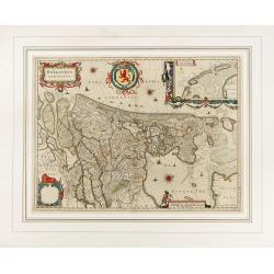
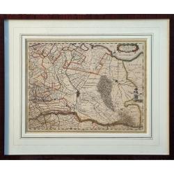
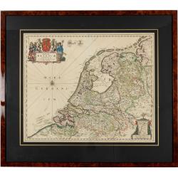
Hollandia Comitatus.
Orientated west to the top of the sheet, this presents the County of Holland in the classical orientation for seventeenth century maps, with Amsterdam at the center. The ...
Date: Amsterdam, 1647
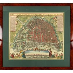
Amstelodami veteris et novissimae urbis accuratissima deline
A decorative plan of the town with at left and right legends mentioning the most important buildings and streets. At bottom center a view of the town from 't IJ. From Atl...
Date: Amsterdam, 1745-1754

Het Huisje door Czaar Peter den Grooten in den Jare 1697 te Zaandam bewoond.
Engraved by Cornelis van Baarsel (Utrecht 1761 - Amsterdam 1826-08-17) after a design of T. Monsieur M.Z. who made his drawing "after nature".A first state, the...
Date: Zaandam, 1823

Het Friessche Doolhoff, het beruchte dorp Molk-Worren
Uncommon map made in 1718 by Johannes Hilarides, principal at the Latin School in Bolsward.. Probably the only printed plan of a Frisian village of that time. The map was...
Date: Amsterdam, 1705

Beschrijving Gezicht van den Ykant af bezyden den Schreiers hoex Toren langs de Keulsche en Geldersche Kaei naer de Nieuwe Markt
This large engraving (560x920mm.) comes from a are series of 25 beautiful large views of Amsterdam and gives a colorful picture of the life and business of the city at th...
Date: Amsterdam, ca. 1720

Kaerte en Afbeeldinge vande Geheele Jurisdictie van Stantdarbuyten Gelegen in de Generaliteit onder Marquisaet van Bergen op den Zoom
With a large title cartouche with signature of the maker Adriaan van der Ende, : Kaerte en Afbeeldinge vande Geheele Jurisdictie van Stantdarbuyten Gelegen in de Generali...
Date: Willemstad, 1737
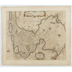
Pascaart..de Zuyder-Zee, Texel..Vlie-stroom..'t Amelander…
An eye-catching chart of the Zuiderzee with east to the top.Pieter Goos (ca. 1616-1675) was one of the most important cartographer, engraver, publisher and print seller o...
Date: Amsterdam, 1666

Circoscrizione delle Provincie ecclesiastiche e Diocesi nei regni del Belgio, ed Olanda (Tav LXI)
This large-format map showing Belgium and Holland with its different dioceses. The map is finely engraved and beautifully colored and was prepared by Girolamo Petri, a la...
Date: Rome, 1858
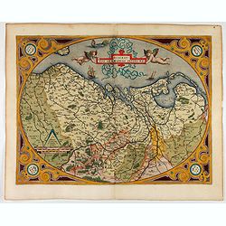
Descriptio Germaniae Inferioris.
The oval map is surrounded by a strapwork frame and the title, adorned with ribbons, is held aloft by two winged cherubs.According to P. Meurer, based on de J ode's 12-sh...
Date: Antwerp, 1587

Amstelodami celeberrimi hollandiae emporii delineatio nova.
Frederik de Wit’s beautiful bird's-eye view of the city. The Amstel river is still open water flowing through the city's heart. Only near the Dam, has it been covered b...
Date: Amsterdam, c.1700
Ultraiectum Dominium.
A highly detailed map of Utrecht and its surroundings in the Netherlands.Additional shipping costs apply. The item is located in Schiedam (The Netherlands) and can be s...
Date: Amsterdam, ca 1635

Slusa, Teutonicae Flandriae opp. . . (Sluis)
Bird'eye view of the town of Sluis.From the greatest publication in this genre!. The Civitates was compiled and written by George Braun, Canon of Cologne Cathedral. Braun...
Date: Cologne, 1580
Pas-Caert vande ghelegetheyt vande Schans te Santvliet, Vertoonede de verdroncken overwaeterde Landen, nieuw aengewasse gorsingen,. . .
Showing the surrounding countryside of the cities of Antwerp, Santvliet, Lillo, Bergen op zoom, etc. The map is ponctuated by several fortifications to indicate the main ...
Date: Amsterdam, 1630

Kaerte van Bergen op Zoom, Steenbergen ende de nieuwe fortificatien gemaeckt tot bevrÿdinge van 't landt van ter Tolen in tjaar 1628.
Very detailed and scarce map showing Bergen Op Zoom, Steenbergen and its surrounding countryside. North to the left side.
Date: Amsterdam, after 1628
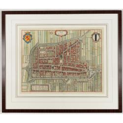
Traiectum Wttrecht
Fine plan of Utrecht from the townbooks "Novum Ac Magnum Theatrum Urbium Belgicae Liberae Ac Foederatae".FRAMED : Additional shipping costs apply. The item is l...
Date: Amsterdam, 1649

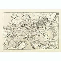
Hollandiae pars septentrionalis, Vulgo Westvriesland..
Based on the work of B.F.van Berckenrode, this fine map, orientated west to the top of the sheet, includes Kennemerland and Hollands Noorderkwartier and is a reasonably u...
Date: Amsterdam, ca. 1667

Het Hooge Heemraedtschap van Schielandt.
This beautiful wall map of "Het Hooge Heemraedtschap van Schielandt" is on nine attached leaves (each leaf 49x58,5 cm. ) engraved by J. VINGBOOMS after J.J. STA...
Date: Rotterdam, A. van Hoorn, 1684

Curia Hollandiae Interior. (Binnenhof)
The government center of the Netherlands is situated in and around the Binnenhof-Buitenhof in The Hague. In 1248 the Roman king Willem II built a castle here and named it...
Date: Amsterdam, 1649

Pascaarte, van de Zuijderzee, Vliestroom, Vlie, en Amelandergat…
Very rare chart of the Dutch Zuiderzee, here in its rare 5th state (o f6). Showing the coastlines along the Dutch inner sea. Two compass roses indicate north to the left ...
Date: Amsterdam, c. 1660
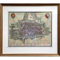
Delfi Batavorum vernacule Delft.
Detailed plan of the city Delft from Frederick de Wit's town book of the Netherlands. The plates are first published by Joan Blaeu one year after the peace of Münster an...
Date: Amsterdam, 1698

Provincie Noord-Braband. / Breda, de Langstraat. . .
Decorative and uncommon custume plate lithographed by R. de Vries and published by Frans Buffa & Zonen in Amsterdam. A group of 4 women from the area of Baronie van B...
Date: Amsterdam, 1857
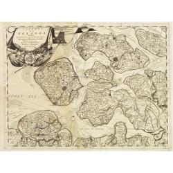
Contado di Zelanda..
A most attractive and decorative map by Vincenzo Coronelli. An elaborate title cartouche garlanded with intertwined flowers and dedicated to Vincenzo Caualli. The remarka...
Date: Venice 1692
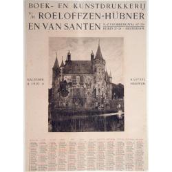
Kasteel Heeswijk.
Very fine etching of the Castle of Heeswijk, by the well-known etcher Ludwig Willem Reymert Wenckebach. He was born in The Hague on 12 January 1860 and died in 1937. The ...
Date: Amsterdam, 1901

Porte de Harlem (Heemstede/Haarlem)
Showing the Haarlemmer Poort (gate) in Heemstede near Haarlem. Likely published by Mondhard, who was a well-known publisher of optical prints, established in rue St.Marti...
Date: Paris, ca. 1750

Vue générale d'Amsterdam.
A so-called optical prints, showing Amsterdam seen from the IJ. A lively scene with extensive shipping. To the left the headquarters of the V.O.C., nowadays the Maritime ...
Date: Paris, ca. 1750

Vue du village de Maarsen en Hollande.
Showing the river Vecht at the town of Maarsen. Published by Jacques Chereau, who was a well-known publisher of optical prints, established in rue St. Jacques in Paris. I...
Date: Paris, ca. 1750

Das Hertzogthum Braband. . .
Charming map of the Dutch and Belgium province of Brabant. With a fine cartouche.
Date: Leipzig, 1749

s'Lands en Oost-Indische Lynbanen.
A decorative print of the Lynbanen a place were V.O.C. ship riggings and ropes were produced and kept.
Date: Amsterdam, 1760-1767

t'Oost-Indisch-Huys.
A decorative print of the East Indian House, the headquarters of the V.O.C., a place for meeting, trading and storage of spices and ship equipment. The maps and charts we...
Date: Amsterdam, 1760-1767

s'Lands en Oost-Indische Lynbanen. & t'Oost-Indisch-Huys.
A decorative print of the Lynbanen a place were V.O.C. ship riggings and ropes were produced and kept.
Date: Amsterdam, 1760-1767

Oost-Indis Zee Magazyn - Arçenal des Indes Orientalis.
Decorative view of the East Indian Arsenal, now-a-says the Maritime Museum.
Date: Amsterdam, ca. 1700

Arcenal de l'Amirauté.
A decorative print of the 'T Landts Magazyn , or 'Scheepvaart Museum' (Naval Museum).
Date: Amsterdam, ca. 1700

D' Admiralyteyts Huys - La maison de l'Amirauté.
Decorative print of the "D'Admiralyteits Huys", Het Prinsenhof, of the Dutch East India Company VOC. Located at the Oudezijds Voorburgwal 195-199, Amsterdam.
Date: Amsterdam, ca. 1700

Het West Indisch Huys.
A decorative print of the West Indian House , the headquarters of the WIC, a place for meeting, trading and storage of spices and ship equipment. The maps and charts were...
Date: Amsterdam, J. van Meurs, 1663
Foederatae Belgicae Tabulae.
Fine, detailed map of the area of the modern Netherlands less the southern part of Limburg, of which the small area around the town of Maastricht is shown in the inset bo...
Date: Amsterdam, 1680

Nieuwe kaart van het oostelykste deel van Holland. . .
Detailed map covering the area of Gouda, IJsselstein, s'Hertogenbosch, Zevenbergen, Dordrecht.
Date: Amsterdam, 1749

Gesigt van den Vermaakelyken Overtoom ... der stad Amsterdam....
A view of the Overtoom in the eighteenth century. Etching on two joined sheets of paper, after A.Rademaker. By the eighteenth century, numerous country villas had been bu...
Date: Amsterdam, 1760

Currus Veliferi Illmi. Pr. Mauritii Nassouvii. (Prince Maurits' sailing-carriage, designed by Simon Stevin. )
Prince Maurits' sailing carriages had been designed by Simon Stevin. The Prince, always accessible to new inventions of his old instructor, could not please the foreign a...
Date: Amsterdam, 1649

A new mape of Ye XVII Provinces of Low Germanie.
Showing all 17 Provinces of the Netherlands before the split between Spain and the Protestant Provinces under the House of Orange. The map was published while the war of ...
Date: London, George Humble, 1626 [1627
![De Texel Stroom met de gaten vant Marsdiep. [with] Caarte van De Mase ende het Goereesche Gat.](/uploads/cache/12097-250x250.jpg)
De Texel Stroom met de gaten vant Marsdiep. [with] Caarte van De Mase ende het Goereesche Gat.
Two decorative charts on one sheet, one depicting Texel and the entrance of the Zuider Zee with an inset showing the north coast of West-Friesland, the other depicting th...
Date: Amsterdam, 1660

Carro, che uà à vela Su le Piagge di Schevelingue.
Italian version of Prince Maurits' sailing carriage designed by Simon Stevin. The big sailing-carriage could seat 28 persons and could reach a speed of seven miles per ho...
Date: Venice, 1707

Provincie Noord-Braband.
Decorative and uncommon costume plate lithographed by Desguerrois & Co. and published by Frans Buffa & Zonen in Amsterdam. 12 illustrations of Brabant costumes: 1...
Date: Amsterdam, 1857

Het stadhuis, van vooren.
The former Amsterdam Town Hall, now the Royal Palace. Copper engraving by Frans de Bakker after Reinier Vinkeles (1741-1816).From the well-known description of Amsterdam ...
Date: Amsterdam, 1765
![Traiectum ad Mosam. [Maastricht]](/uploads/cache/47901-250x250.jpg)
Traiectum ad Mosam. [Maastricht]
A birds-eye view of Maastricht seen from the south. Rising on Vrijthof square is the dominant complex of Sint-Servaas, in front of which - seen here in a distorted perspe...
Date: Cologne, ca. 1581

Inferior Germania.
A rare miniature map of present-day The Netherlands and Belgium. Strap-work title cartouche in the lower right corner with scale. Expertly engraved by Petrus Kaerius, the...
Date: Amsterdam, 1606

Deliciae Batavicae.
It is a charming book illustrated with portraits of Willem of Orange and Prince Maurits and eight engraved armorial plates. Followed by 30 engraved views or scenes of ...
Date: Amsterdam, Johannes Janssonius, 1618

Belgii sive Germaniae Inferioris accuratissima tabula.
Very rare and very decorative map with in the right and left borders costumed figures and town plans alternately. In top and bottom border town plans and views.Separate p...
Date: Amsterdam, 1631

De Zype. / Purmer / Wormer/ Beemster / Waterland.
Five maps on one sheet. Showing the polders of De Zype, De Purmer, De Wormer, De Beemster and a map of Waterland, including de Bylmermeer and Monnekedam. Showing the Noor...
Date: Amsterdam, 1652-1658

Episcop. Ultraiectinus.
A very detailed map based on Utrecht. Scale cartouche held by a surveyor. Based on the map by B.F.van Berckenrode (1620-21) and engraved by the master engraver Evert Sijm...
Date: Amsterdam, 1630-1632

Vue du village de Maarsen en Hollande.
Showing the river Vecht at the town of Maarsen. Published by Jacques Chereau, who was a well-known publisher of optical prints, established in rue St. Jacques in Paris. I...
Date: Paris, ca. 1750

Vue perspective edu fauxbourg et du port de Scheveningue a une lieue de la Haye, en Hollande.
Optical print showing the village and harbor of Scheveningen with the church at the right, in the background the North Sea. In the background, the summer residence Nieuw ...
Date: Paris, ca. 1750

A view of Amsterdam taken from the Old Rampart.
So-called optical print of Amsterdam, published by Jean Mondhare after a print by Laurie and Wtitle. With captions in English and French above and belowIn the eighteenth ...
Date: Paris, ca. 1760

Amsterdam Capitale de la Hollande.
A panoramic of Amsterdam seen from 't IJ. Set within a decorative border, printed from a separate plate. Rare.
Date: Leiden, 1720

Kaart van Zeeland.
Fine map of the province of Zeeland, with the fortified cities are highlighted in red. Isaac Tirion was born in Utrecht ca. 1705. He came to Amsterdam ca. 1725. Tirion pu...
Date: Amsterdam, 1747

Vermakelykheden van Brabant, en deszelfs onderhoorige Landen... (2 volumes)
Topographical and iconographical work on Brabant illustrated with 1 engr. title-vignette and 190 engraved views, plans & armorial plates by J. Harrewijn, G. Bouttats ...
Date: Amsterdam, P.J. Entrop, 1768

Frisia occidentalis.
A rare separately published carte-a-figures of Friesland by Geelkercken in its first state. The title and the coats of arms of the eleven Frisian towns appear in the cent...
Date: [Leeuwarden], Dierick Albertsen, 1618

Amstelodamum, Celebre Emporium Forma Plana.
Second state of this rare and decorative plan of Amsterdam with Visscher's imprint. With a panoramic view seen from the IJ and further insets of Council House, The Exchan...
Date: Amsterdam, c. 1636

Nieuw Nederlandtsch Caertboeck. Waer in volkomentlijcker als oyt te voren vertoont werden de XVII. Nederlanden.
Rare first edition of this atlas of the provinces of the Netherlands, Belgium and Luxemburg. Engraved title page, with : "Gedruckt t' Amsterdam by Abraham Goos Plaet...
Date: Amsterdam, 1616

Descrittione di M. Lodovico Guicciardini patritio Fiorentino, di tutti i Paesi Bassi,...
Second Italian edition (variant B) and first Plantin edition (1st Silvius 1567) and the most sought-after edition of the famous description of the Low Countries, updated ...
Date: Antwerp, Plantin, 1581

Amsterdam Ville du comté de Hollande. . .
A very decorative and very rare town-view of Amsterdam, including a numbered key ( A- T) in the lower part. Engraved by Pierre-Alexandre Aveline. With the signature "...
Date: Paris, ca.1692

Sexta Etas Mundi. Folium. CCXVII (dancers of Maastricht).
Latin text page with woodcuts of male Siamese twins, a man headed lion. The large illustration is the only illustration related to the Netherlands : it shows a bridge col...
Date: Nuremberg, 12 July 1493
Selling price: ????
Please login to see price!
Sold in 2024

Ultrajectum.
An original early 17th century copper engraved miniature antique map of the Dutch province of Utrecht by Petrus Bertius, that was published in Amsterdam at the beginning ...
Date: Amsterdam, 1606

Nova XVII Provinciarum Inferioris Germaniae descriptio .
Extremely rare map of the Benelux by Frederick de Widt. Originally engraved and published by P.Kaerius in 1607. In 1662 the plate came in the possession of Frederick de W...
Date: Amsterdam, 1662

Plan de la ville de Maestricht avec ses attaques commandées par M. le maréchal de Saxe, depuis le 15 avril jusqu'au 3 may 1748 . . .
A plan of Maastricht rising after the capture of the city by the French troops led by the Marshal of Saxony. The city was besieged between 15 April and 3 May 1748, during...
Date: Paris, 1781

Nieuwe en zeer accuraate Zee-Caart van de Hollandse Wal strekkende van de Maas tot Texel opgenomen door Jan Rokusz Douw, , ,
A very fine and rare chart of the coast of Holland, Prepared by Jan Rokusz, Douw and Agge Roskam Kool.Embellished with a very decorative cartouche with a dedicational tex...
Date: Amsterdam, 1750
Ducatus Limburg.
A very rare issue of this map of Limburg. Cornelis Danckerts II. copied the folio map of H.Hondius.The publisher's address was placed in the lower right-hand corner. The ...
Date: Amsterdam, 1636

Amsterdam Ville du Comté de Hollande et la plus considerable des Provinces Unies. . .
A very decorative and extremely rare town-view of Amsterdam, including a numbered (1-18) key in lower part. Extensive shipping on the IJ. To the left the headquarters of ...
Date: Paris, ca.1750

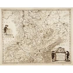
Limburgensis Ducatus Tabula Nova.
Map of Limburg, prepared by the Antwerp expert in law and mathematics Aegidius Martini. After 1600 Jan Baptist Vrients acquired the stock and the plates of Ortelius' Thea...
Date: Antwerp, 1606-1612

Middelbourg Ville la plus considerable de l'Isle de Walcheren et du Comté de Zelande l'une des huit provinces Unis des pais-bas . .
A very decorative and extremely rare of Middelburg, including a numbered (1-19) key in lower part. Published by Jacques Chéreau, (1688 - 1776). Engraved by Aveline and ...
Date: Paris, ca.1750

Die Zyp / La Zype.
A miniature map showing the polder of De Zype. Title cartouche in the upper side.First published in 1598 in his Caert-Thresoor, the plates were executed by the most famou...
Date: Amsterdam / Frankfurt, 1609

Vue de Gattweick et de l'embouchure du Rhin, dans la Mer du Nord.
Very decorative view of Katwijk. Signed lower right, Louis Bleuler au chateau de Laufen . Original design by Louis Bleuer. This gouache was the model for his aquatint in ...
Date: 1820

Les Provinces des Pays Bas.
RARE. From his first edition of his only folio atlas, the map is relied upon the map of his uncle, Nicolas Sanson. Engraved by I.Somer.A nice map of Netherlands.
Date: Paris 1687
Sint Catharinakerk te Eindhoven.
Uncommon woodblock engraving of St.Catharina church of Eindhoven, built by the well-known architect P.Cuijpers. Published in Katholieke Illustratie.The "katholieke i...
Date: 'sHertogenbosch, Henri Bogaerts, 1875

Les Provinces confederées du Pais-Bas
The first wall map of the Seven Provinces of 1651, re-issued as 'Stoel des Oorlogs' by Covens & Mortier. The first issue of the present wall-map is known to be includ...
Date: Amsterdam, c. 1740

Quarta pars Brabantiae cujus caput Sylvaducis.
A good and dark impression in strong original colors.The third state. The coat of arms of Brabant and 's-Hertogenbosch appears on the map. The municipal arms in the colum...
Date: Amsterdam, 1645

Quarta pars Brabantiae cujus caput Sylvaducis.
A good and dark impression in strong original colors.The third state. The coat of arms of Brabant and 's-Hertogenbosch appears on the map. The municipal arms in the colum...
Date: Amsterdam, 1645

Over deese grietenije.. Eerste van Wester Goo..
Very decorative map centered on Menaam, Marsum and Boxum from the Uitbeelding der Heerlijkheit Friesland prepared by Schotanus. With ornamental title cartouche lower righ...
Date: Leeuwarden, F.Halma, 1718

Perspective du Voorhout, promenade publique de La Haye.
Showing the Voorhout in The Hague. Likely published by Mondhard, a well-known publisher of optical prints, established on rue St. Martin in Paris. In the eighteenth and n...
Date: Paris, ca. 1750

III. Carte de la Hollande.. Over-Yssel.
Attractive small map centered on the delta of the River Ijssel, where it discharges into the Zuiderzee.From Atlas Portatif Universel, by Robert de Vaugondy. Unrecorded st...
Date: Paris, later than 1748