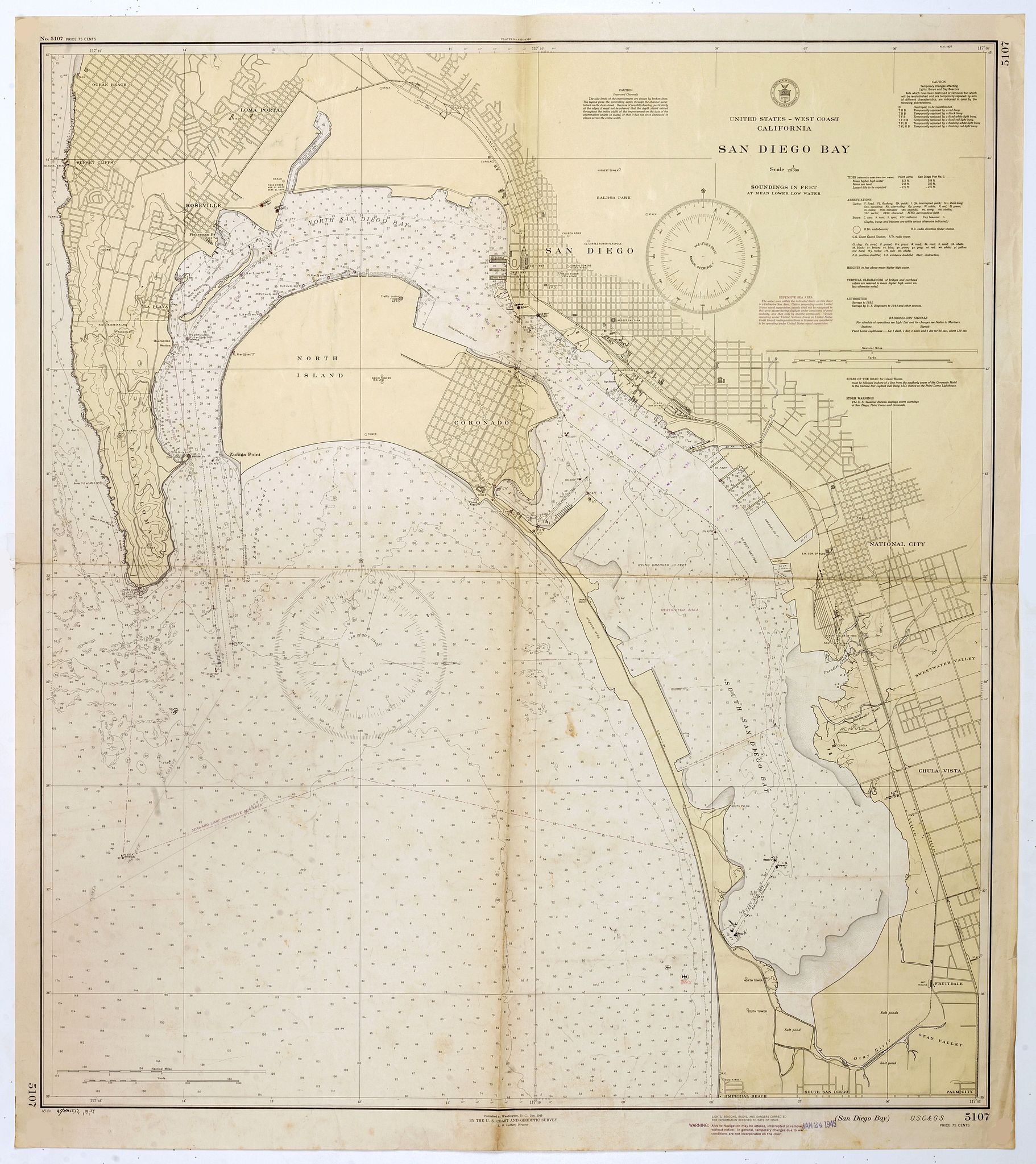
1945 U.S. COAST AND GEODETIC SURVEY - Nautical chart of San Diego Bay of 1945. Printed in black, yellow and purple the "Seaward limit defensive sea area".
San Diego Bay. (Chart 5107) |
||||||||||||||||||||
|
||||||||||||||||||||
|
|
||||||||||||||||||||
$500 / ≈ €439
This item is available for immediate sale
|
My Collection +
Add this or any of your favorite items in one place. If you want to save the items permanently, you have to sign in or create an account first. |
|||||||||||||||||||
Description
Nautical chart of San Diego Bay of 1945. Printed in black, yellow and purple the "Seaward limit defensive sea area". The water area within the indicated limits on this chart is a Defensive Sea Area. Unless proceeding under United States naval supervision, vessels shall not be navigated in this area except during daylight under conditions of good visibility, and then only under specific conditions.
In lower margin "WARNING : Aids to Navigate may be altered, interrupted or removed without notice. In general, temporary changes due to war conditions are not incorporated on the chart.
San Diego had long before the war become a "Navy town" because of the many naval and Coast Guard facilities here. Early in the war San Diego was chosen as the new headquarters of the Pacific Fleet after the headquarters left Honolulu.
During the first weeks of the war, fears of an invasion and/or air attacks were strong here as they were elsewhere in California. At that time, the city's only air defenses were the guns on the ships in the harbor. This was soon corrected as the Army moved in as soon as it could to provide adequate air defenses.
Arrangements were made between the U.S. Government and the Government of Mexico to allow joint teams of U.S. Army officers and Mexicans Army officers and soldiers to patrol the Mexican peninsula of Baja California.
The teams were platoon-size units and patrolled all the way to the southern tip of the peninsula. There were persistent rumors early in the war that the Japanese might have secret air bases in Baja California, but no evidence of this was ever found.
The American officers were required to wear civilian clothing and all U.S. markings had to be removed from U.S. Army vehicles and other equipment to accommodate Mexico's neutrality laws.
FAQ - Guarantee - Shipping
Buying in the BuyNow Gallery
This item is available for immediate purchase when a "Add to Cart" or "Inquire Now" button is shown.
Items are sold in the EU margin scheme
Payments are accepted in Euros or US Dollars.
Authenticity Guarantee
 We provide professional descriptions, condition report (based on 45 years experience in the map business)
Paulus Swaen warrants the authenticity of our items and a certificate of authenticity is provided for each acquired lot.
Condition and Coloring
We indicate the condition of each item and use our unnique HiBCoR grading system in which four key items determine a map's value: Historical Importance, Beauty, Condition/Coloring and Rarity.
Color Key
We offer many maps in their original black and white condition. We do not systematically color-up maps to make them more sellable to the general public or buyer.
Copper engraved or wood block maps are always hand colored. Maps were initially colored for aesthetic reasons and to improve readability. Nowadays, it is becoming a challenge to find maps in their original colors and are therefor more valuable.
We use the following color keys in our catalog:
Original colors; mean that the colors have been applied around the time the map was issued.
Original o/l colors; means the map has only the borders colored at the time of publication.
Colored; If the colors are applied recently or at the end of the 20th century.
Read more about coloring of maps [+]
Shipping fee
A flat shipping fee of $ 30 is added to each shipment by DHL within Europe and North America. This covers : International Priority shipping, Packing and Insurance (up to the invoice amount).
Shipments to Asia are $ 40 and rest of the world $50
We charge only one shipping fee when you have been successful on multiple items or when you want to combine gallery and auction purchases.
Read more about invoicing and shipping
FAQ
Please have a look for more information about buying in the BuyNow gallery
Many answers are likely to find in the general help section.
My Collection+
![]()
With My Collection+ you can collect all your favorite items in one place. It is free, and anyone can create his or her virtual collection.
Unless you are logged in, the item is only saved for this session. You have to be registed and logged-in if you want to save this item permanently to My Collection+.
Read More[+]
Register here, it is free and you do not need a credit card.
Add this item to
My Collection+
or click the following link to see My Collection+.
| Digital Image Download | |
|
Paulus Swaen maintains an archive of most of our high-resolution rare maps, prints, posters and medieval manuscript scans. We make them freely available for download and study. Read more about free image download |
Click the image for a free small image download. |
In accordance with the EU Consumer Rights Directive and habitually reside in the European Union you have the right to cancel the contract for the purchase of a lot, without giving any reason.
The cancellation period will expire 14 calendar days from the day after the date on which you or a third party (other than the carrier and indicated by you) acquires, physical possession of the lot. To exercise the right to cancel you must inform Paulus Swaen Inc, of your decision to cancel this contract by a clear statement (e.g. a letter sent by post, or e-mail.
To meet the cancellation deadline, it is sufficient for you to send your communication concerning your exercise of the right to cancel before the cancellation period has expired.
