Popular Listings in Europe

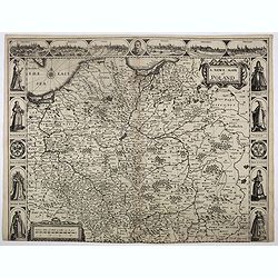
Hassia Landgraviatus.
Centered on the town of Kassel.
Date: Amsterdam, 1650

Typus Galliae Veteris, Ex conatib' Geograph. Abrah.Ortelii.
A very decorative map with countries of ancient France prepared by Abraham Ortelius and published by one of the most famous map publishers, Willem Blaeu.
Date: Amsterdam, 1645
Selling price: ????
Please login to see price!
Sold in 2026

Völker Europas wie schön sind eure Geschichter. (World War I post card)
During the Great War, when the only means of communicating news to the masses was by newspapers and weekly illustrated magazines, the ‘war’ or 'military' picture postcard...
Date: Germany, 1915

A view of Amsterdam taken from the Old Rampart.
So-called optical print of Amsterdam, published by Jean Mondhare after a print by Laurie and Wtitle. With captions in English and French above and belowIn the eighteenth ...
Date: Paris, ca. 1760

't dorp Aalst.
Rare print of the old church of Aalst (near Eindhoven), from Vaderlandsche gezichten of afbeeldingen.. by J.Bulthuis, printed by H.Gartman in Amsterdam.
Date: Amsterdam, 1786 / 1792

Het West Indisch Huys.
A decorative print of the West Indian House , the headquarters of the WIC, a place for meeting, trading and storage of spices and ship equipment. The maps and charts were...
Date: Amsterdam, J. van Meurs, 1663

Ruremunda Gelriae opp.
A bird's eye town-plan of the town of Roermond. From the first Dutch translation of Guicciardini's description of the Netherlands.
Date: Amsterdam, 1612

Vue générale d'Amsterdam.
A so-called optical prints, showing Amsterdam seen from the IJ. A lively scene with extensive shipping. To the left the headquarters of the V.O.C., nowadays the Maritime ...
Date: Paris, ca. 1750

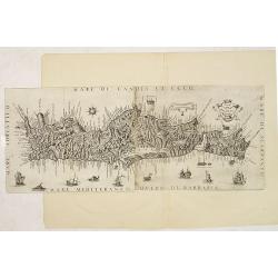
Plan de la Baye de Ville Franche et de celle de St. Souspir.
An attractive chart centered on the Mediterranean. With scale and large compass-rose. Dated 1727, with the privilege of the King. From : Recueil des Plusieurs plans des p...
Date: Marseille, 1730

Vue perspective edu fauxbourg et du port de Scheveningue a une lieue de la Haye, en Hollande.
Optical print showing the village and harbor of Scheveningen with the church at the right, in the background the North Sea. In the background, the summer residence Nieuw ...
Date: Paris, ca. 1750

Carte particuliere d'une grande partie des estats situez sur le haut rhein et sur les rivieres qui si déchargent comme sont L'Alsace, la Souabe et la Lorraine,&c. . .
Detailed map of Alsace, Lorraine and Souabe, centered on the River Rhine.
Date: Paris, 1705
![Stampalia. [Map of Astypalaia]](/uploads/cache/45244-250x250.jpg)
Stampalia. [Map of Astypalaia]
Very rare map of the Greek island Astypalaia. The island is known in Italian as Stampalia. Published in the first edition of "Viaggio da Venetia, a Costantinopoli. P...
Date: Venice, Giacomo Franco, 1598
![[Set of 6 maps] Charta öfver Storfurstendömet Finland på Friherre S. G. Hermelins Anstalt och Omkostnad. Sammandragen och författad af C. P. Hällström. Philos. Magister och Auscultant i Kongl. BergsColl. 1799.](/uploads/cache/34482-250x250.jpg)
[Set of 6 maps] Charta öfver Storfurstendömet Finland på Friherre S. G. Hermelins Anstalt och Omkostnad. Sammandragen och författad af C. P. Hällström. Philos. Magister och Auscultant i Kongl. BergsColl. 1799.
This is a beautiful set of a key map and five separate maps of Samuel Gustav Hermelin's map of Finland. The maps have been engraved by Fredrik Akrel, a very skilled and p...
Date: Källa: J.Strang & E.- S. Harju: Suomen karttakirja 1799

Plan de Paris commencé l'année 1734, Dessiné et gravé sous les ordres de Messire Michel Etienne Turgot, prévost des marchands.
FIRST EDITION of Turgot's Monumental Joined View of Paris, stretching to over 10 Feet. This expansive large-scale engraved view of Paris covers the first eleven arrondiss...
Date: Paris, 1739

Isola d'Oleron, nella piaggie occidentali della Francia.
A beautiful and rare map showing île d'Oleron.The remarkable Vincenzo Coronelli (1650-1718), encyclopaedist, geographer, inventor and Doctor of Theology, was citizen of t...
Date: Venice, 1690

Société de la Charité Maternelle à Paris. Plan de le ville de Paris, Divisé par Quartiers avec Nomenclature.
>Rare atlas de Paris dressé par E. Devrainne, divisé en 80 quartiers et colorié par Le Roux (Le Roux pinxit). Illustré d'une page de titre aux armes de Paris avec sa d...
Date: Imprimerie Mercier, Clichy, 1876

La pericolante ostinata. Papagallo No. 20 Anno II.
Design by Augusto Grossi. Taken from the Italian satirical newspaper Il Papagallo, a satirical magazine founded in January 1873 by Augusto Grossi (1835-1919), which speci...
Date: Bologne, 1874
![[ Map of the island Nexos]](/uploads/cache/45289-250x250.jpg)
[ Map of the island Nexos]
1598 - ROSACCIO, Giuseppe. - Very rare map of the island of Naxos published in the first edition of "Viaggio da Venetia, a Costantinopoli".
Date: Venice, Giacomo Franco, 1598
Selling price: ????
Please login to see price!
Sold in 2026

Plan de la ville de Maestricht avec ses attaques commandées par M. le maréchal de Saxe, depuis le 15 avril jusqu'au 3 may 1748 . . .
A plan of Maastricht rising after the capture of the city by the French troops led by the Marshal of Saxony. The city was besieged between 15 April and 3 May 1748, during...
Date: Paris, 1781

Het stadhuis, van vooren.
The former Amsterdam Town Hall, now the Royal Palace. Copper engraving by Frans de Bakker after Reinier Vinkeles (1741-1816).From the well-known description of Amsterdam ...
Date: Amsterdam, 1765

Urbium Londini et West-Monasterii nec non Surburbii Southwark Accurata Ichnographia ,., Neuester Grundris der Staedte London und West-Munster, Samt der Vorstadt Southwark ,.,
Detailed plan of London, extending from Grosvenor Square in the west to Mile End to the east, To the right inset views of St, James's Square, and Custom House, elevations...
Date: Nuremberg, 1736

A view of Westminster bridge. Vue du pont Westminster.
A very decorative and extremely rare collection of river Themes and Westminster Bridge in London, including a six-line description in French and English. Published by Jac...
Date: Paris, ca.1750
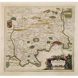
Middle-sexia.
Double-page map of the old Middlesex County, including a marvelous depiction of London on the Thames in the lower right corner. Decorative cartouche and coat of arms. Lat...
Date: Amsterdam, 1662
Selling price: ????
Please login to see price!
Sold in 2024

Languedoc - Foix Roussillon.
Very decorative, informative map of Languedoc - Foix Roussillon region in south eastern France. Including the towns of Carcassonne, Montpellier, Albi, Toulouse, etc.The m...
Date: France, 1943
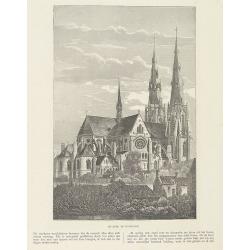
Sint Catharinakerk te Eindhoven.
Uncommon woodblock engraving of St.Catharina church of Eindhoven, built by the well-known architect P.Cuijpers. Published in Katholieke Illustratie.The "katholieke i...
Date: 'sHertogenbosch, Henri Bogaerts, 1875

Profil de la renomée ville et port d'Emstredam cappitalle des estats de Hollande.
Extremely rare panoramic town-view of Amsterdam seen from the river IJ.Exceptional bright, sharp example.The print is skillful copy of the print of Matthieu Merian, now w...
Date: Paris, 1647

Nieuwe kaart van het Koningrijk der Nederlanden. . .
Uncommon map of the Netherlands prepared by J.S. Smulders and P. H. Witkamp and lithographed by Z.M. den Koning in the Hague. Dated.Showing The Kingdom of the Netherlands...
Date: The Hague, 1874

Nova Germaniae Descriptio..
A finely engraved carte à figures, with the side borders depicting emperors, while the upper and lower panels contain finely engraved miniature town prospects, among them...
Date: Amsterdam, 1632

Optique de St.Cloud.
This perspective view of St. Cloud comprises 6 hand colored images of the grand Bassin d'Apollon viewed through an square and two round holes cut out from the front card ...
Date: Paris, ca.1845

Circoscrizione delle Provincie ecclesiastiche e Diocesi nei regni del Belgio, ed Olanda (Tav LXI)
This large-format map showing Belgium and Holland with its different dioceses. The map is finely engraved and beautifully colored and was prepared by Girolamo Petri, a la...
Date: Rome, 1858

Amsterdam Ville du Comté de Hollande et la plus considerable des Provinces Unies. . .
A very decorative and extremely rare town-view of Amsterdam, including a numbered (1-18) key in lower part. Extensive shipping on the IJ. To the left the headquarters of ...
Date: Paris, ca.1750

Neapolis.
A rare panoramic of Naples with over the whole length of the lower part 3 columns of poems in Latin, Dutch and French.Published by Dancker Danckerts (1634-1666).
Date: Amsterdam, 1660

Mappa Humoristico da Europa.
A really unusual and lovely map, published in Portugal at the outbreak of The Great War in 1914. This outbreak of war in Europe was the result of a complex sequence of ev...
Date: Lisbon, 1914

Tabula Episcopatuum Leodiensis et Coloniensis. . .
Rare issue of Cornelis Danckert's attractive map of Limburg, shows the area of Cologne, Mainz, Trier, Jülich, Mons, Antwerp and Liege in Belgium.Decorative title cartouch...
Date: Amsterdam, 1700
![Rodi [View of Rhodes]](/uploads/cache/45236-250x250.jpg)
Rodi [View of Rhodes]
Very rare view of the City of Rhodes on the island of Rhodes. Historically, Rhodes island was very famous worldwide for the Colossus of Rhodes, one of the Seven Wonders o...
Date: Venice, Giacomo Franco, 1598

Carro, che uà à vela Su le Piagge di Schevelingue.
Italian version of Prince Maurits' sailing carriage designed by Simon Stevin. The big sailing-carriage could seat 28 persons and could reach a speed of seven miles per ho...
Date: Venice, 1707

Vue du village de Maarsen en Hollande.
Showing the river Vecht at the town of Maarsen. Published by Jacques Chereau, who was a well-known publisher of optical prints, established in rue St. Jacques in Paris. I...
Date: Paris, ca. 1750

Vuë du dedans de l'Eglise de St. MARTIN à Londre.
So-called optical print illustrating a perspective view of the central aisle of St. Martin's church, in London.In the eighteenth and nineteenth centuries, many popular sp...
Date: Paris, 1760

Gesigt van den Vermaakelyken Overtoom ... der stad Amsterdam....
A view of the Overtoom in the eighteenth century. Etching on two joined sheets of paper, after A.Rademaker. By the eighteenth century, numerous country villas had been bu...
Date: Amsterdam, 1760

Teatro della guerra nelle Flandre Austriache e Francesi. . .
Rare folio-sized map of Belgium by Antonio Zatta e Figli, from a never-finished atlas by the ‘Società Calcografia’, a partnership of the two main Venetian publishers of t...
Date: Venise, 1803

St Tropez.
Early plan of St.Tropez. From his "Introduction à la fortification".
Date: Paris, 1693

Paris.
This is a spectacular panoramic view of Paris, with legends numbered from 1 to 70 in French. The title is in a banderol.After a design by Friedrich Bernhard Werner (1690-...
Date: Augsbourg, ca. 1740

De custen van een deel van Denemarken en Swede. . .
A detailed chart of the coast Skane and Kalmar, with the island Öland. Decorated by a title and scale cartouche, a compass rose, several vessels and sea monsters, and dep...
Date: Leiden, Plantijn, 1585

Latium.
Based on classical authors' sources, specifically Virgilius, Plinius, Varro, Halicarnasseus, Festus and Ausonius.Philip Wingius in his letter to Ortelius from 1592 mentio...
Date: Antwerp, 1595
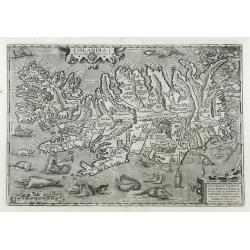
Islandia.
1603 ORTELIUS, A. - Perhaps the most famous map of Iceland. On the south side of the island, a collection of all possible sea monsters is depicted. Polar bears on ice flo...
Date: Antwerp, 1603

Dynastiae Comitat. Schoenburgici Penig, Remissa, Rochsburg, Wechselburg In Clientela Elect: Saxon Glaucha, Hartenstein, Lichtenststein, Walkenburg. . .
A very uncommon and superbly decorative map of Lower Saxony, the region southwest of Dresden. Including the towns of Rochlitz, Geringswalde, Mittweida, Frankenberg, Chemn...
Date: Augsburg, 1750
![[Voyage en Suisse / Reise die Schweiz.]](/uploads/cache/48396-250x250.jpg)
[Voyage en Suisse / Reise die Schweiz.]
A first edition children's folding board game of Switzerland and its many places and sights to visit. Although it is missing most of its original components (dice, cards,...
Date: Switzerland, 1891

(Lübeck) Lvbeca vrbs. imperialis libera. civitatvm. Wandalicarvm. . . .
Impressive, more than 3 meters wide panoramic town view after a woodblock engraving from Elias Diebel, initially made in 1552. Of this original woodblock, Bachmann mentio...
Date: Germany, c. 1855

Picardie Meridionale Le Cambresis et leurs Environs.
Map showing the region of Picardie in Northern France. Including the towns of Abbeville, Amiens, Compiegne, Soisson, Chambray, etc.
Date: Paris, 1737
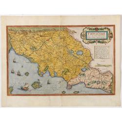
Thusciae Descriptio Auctore Hieronimo Bellarmato.
Decorative and detailed map of Tuscany, from the 1574 or 1575 Latin text edition of Ortelius' Theatrum Orbis Terrarum, the first modern atlas of the world. The map is bas...
Date: Antwerp, 1574-1575

Vuë de l'ancien Palais d'hiver de sa Majesté Imperiale et du Canal qui Joint la Moika avec la Neva, a St. Petersburg.
So-called optical print illustrating a perspective view of St. Petersburg, namely the ancient Winter Palace and the canal which joins the Moika to the Neva.In the eightee...
Date: Paris, 1760

(upper sheets only) Asia According to the Sieur D'Anville Divided into its Empires, Kingdoms and States Showing the European Settlements in the East Indies and all the New Discoveries . . . 1772
Highly detailed map of Russia, including Turkey, China and Korea. Based on the cartography of the famous French cartographer Jean Baptiste Bourguignon d' Anville. Only th...
Date: London, 1772
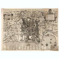
Palermo.
Rare bird's-eye view of Palermo, the plan showing the city and harbor within the city walls, with the surrounding countryside, title and dedicatory verse set in elaborate...
Date: Seina, ca. 1600

Beschrijving Gezicht van den Ykant af bezyden den Schreiers hoex Toren langs de Keulsche en Geldersche Kaei naer de Nieuwe Markt
This large engraving (560x920mm.) comes from a are series of 25 beautiful large views of Amsterdam and gives a colorful picture of the life and business of the city at th...
Date: Amsterdam, ca. 1720

Nouveau théâtre de la guerre entre les Russes les turcs et les polonois confédérés.
A very rare separately published map of Crime region. With a large title cartouche lower left "Nouveau theâtre de la guerre entre les russes, les turcs et les polono...
Date: Paris, 1769

Marchionatus Sacri Romani Imperii.
A wonderfully decorative map showing in the middle of the image a town plan from Antwerp and in the lower part an inset with a panoramic view of the city and harbour of A...
Date: Amsterdam, 1617- 1624

Chaerte vande Wieringer waert, de welcke inden jaere XVI… (Wieringerwaard)
Rare wall map of the Wieringerwaard polder, as raffled on 12 July 1611. The polder was laid dry in 1610. It border, and the municipality's border, were the Zuiderzee, the...
Date: 1741-1744

Vue du village de Maarsen en Hollande.
Showing the river Vecht at the town of Maarsen. Published by Jacques Chereau, who was a well-known publisher of optical prints, established in rue St. Jacques in Paris. I...
Date: Paris, ca. 1750

Kaerte van Bergen op Zoom, Steenbergen ende de nieuwe fortificatien gemaeckt tot bevrÿdinge van 't landt van ter Tolen in tjaar 1628.
Very detailed and scarce map showing Bergen Op Zoom, Steenbergen and its surrounding countryside. North to the left side.
Date: Amsterdam, after 1628

(Art déco gouache with winter scene of The Palace of Westminster )
Outstanding "art deco" gouache (unsigned) from the workshop of "Robert Pichon. Ateliers de Dessin et Lithographie – 10, rue Rochechouart – Paris. The goua...
Date: Paris, ca. 1930

Il vero ritratto di Nettvno al presente oaupato da gl'imperiali.
Rare and early town-plan of Nettuno, in the province of Rome, which is nowadays a touristic harbor.Issued by Joannes Orlandi who acquired many Lafreri plates, which he re...
Date: Rome, 1557 / 1602

Carte du Gouvernement de Provence, suivant les nouvelles observations...
Fine copper engraved and decorative map of the Provence region in the south of France. It includes the cities of Nimes, Viviers, Avignon, Aix and Nice. The pictorial cart...
Date: Amsterdam 1728

La Saxe Contenant le Routes et les postes. . .
Fine post-route map of Saxony in Germany with a splendidly engraved title cartouche. The map is centered on Leipzig. George Louis Le Rouge was active between 1740 and 178...
Date: Paris, 1756
Selling price: ????
Please login to see price!
Sold in 2025

Prospectus veteris castelli Graviae.
One of the earliest views of the ancient Castle of Grave. Engraved by Casper Bouttats. With a description in Latin, French and Dutch.
Date: Amsterdam, 1695

Nieuwe Kaart van de Westfaalse Kreits..
Isaac Tirion was born in Utrecht ca. 1705. He came to Amsterdam ca. 1725. Tirion published a number of important books, many of which are still in demand for their intere...
Date: Amsterdam, 1745
![[ Spitzbergen ]](/uploads/cache/27541-250x250.jpg)
[ Spitzbergen ]
Two aquatints depicting the northern coasts of the Spitzbergen engraved by Fumagalli. From Giulio Ferrario's work Le Costume Ancien et Moderne ou Histoire du gouvernemen...
Date: Milan, 1827

Nouvelle et exacte Carte du Duche de Brabant. . .
A very rare example of a map of the Duchy of Brabant. Title cartouche in the lower left-hand corner. A very rare issue of this map of Brabant. Cornelis Danckerts II. copi...
Date: Amsterdam, 1635

Provincie Noord-Braband. / Breda, de Langstraat. . .
Decorative and uncommon custume plate lithographed by R. de Vries and published by Frans Buffa & Zonen in Amsterdam. A group of 4 women from the area of Baronie van B...
Date: Amsterdam, 1857

Carte du Palatinat du Rhin.
Decorative "carte à figures"- map centered on Koblenz, Metz, Strasburg, Manheim and Heidelberg, with the river Rhine by François Jollain (ca. 1641 – 18 April 17...
Date: Paris, ca. 1688
Il Regno Di Candia.
This rare map is based on the important map of Crete by Basilicata. The maps by Marco Boschini reached a wider audience than the few individuals for whom the Basilicata m...
Date: Venice, 1660
A Newe mape of Poland Done into English by I.Speede.
A wonderful map of Poland. Incorporated into Speed's 'Prospect Of The Most Famous Parts Of The World'. Includes birds-eye views of Cracow, Dantzick, Posna, Crossen, Sando...
Date: London, 1627

s'Lands en Oost-Indische Lynbanen. & t'Oost-Indisch-Huys.
A decorative print of the Lynbanen a place were V.O.C. ship riggings and ropes were produced and kept.
Date: Amsterdam, 1760-1767

Le Cours de l'Elbe et de l'Oder où sont les Electorats de Saxe et de Brandebourg, les Duchés de Mekelbourg et de Pomeranie. . .
A detailed and scarce map showing the rivers Elbe and Oder in Germany and Poland. Dark engraving.This is one sheet of the four sheet wall map by Pierre Du Val entitled: &...
Date: Paris, 1684

Malte Vue prise de la Mer. - Malta Vista lomada del mar.
Very decorative view of the Grand Harbour of Malta by Louis Lebreton, published in "Ports de Mer d’Europe" in 1859 by L. Turgis in Paris.This lithography shows ...
Date: Paris, Turgis, 1859

Porte de Harlem (Heemstede/Haarlem)
Showing the Haarlemmer Poort (gate) in Heemstede near Haarlem. Likely published by Mondhard, who was a well-known publisher of optical prints, established in rue St.Marti...
Date: Paris, ca. 1750
Kasteel Heeswijk.
Very fine etching of the Castle of Heeswijk, by the well-known etcher Ludwig Willem Reymert Wenckebach. He was born in The Hague on 12 January 1860 and died in 1937. The ...
Date: Amsterdam, 1901

Kasteel Croij.
Decorative lithography of the castle of Croij.
Date: Den Haag, 1880
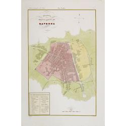
Pianta della citta di Ravenna.
Very finely engraved and detailed plan of Ravenna. Engraved by V.Angeli and included in: Atlante Geografico dell Italia. To the lower left a key to the principal building...
Date: Rome, 1860
![[Map of Corfu. View of the city of Corfu on the foreground. ]](/uploads/cache/45221-250x250.jpg)
[Map of Corfu. View of the city of Corfu on the foreground. ]
Very rare map of Corfu with a view of the city of Corfu on the foreground. Published in the first edition of "Viaggio da Venetia, a Costantinopoli. Per Mare, e per T...
Date: Venice, Giacomo Franco, 1598

Vue de la ville et du château de Heidelberg . . . Ansicht der stadt und des schlosses Heidelberger . . .
Engraving after Louis Charles François de Graimberg-Belleau. Engraved by Ch. Haldennvang.French artist. Son of Gilles-François Belleau Graimberg. Louis Charles François e...
Date: Graimberg, Heidelberg, ca. 1840
