Popular Listings in Europe

Wandkarte von Europa von H.Berghaus. . .
Large wall map of Europe printed in chromo-lithography. Prepared by Heinrich Berghaus and published by Justus Perthes in Gotha.Heinrich Berghaus, with support of Alexande...
Date: Gotha, Perthes, ca.1885

Die Stadt Narva. . .
An early of the town of Narva, located at the eastern tip of Estonia, on the Russian border.From the uncommon Hamburg edition "Viel Vermehrte Moscowitische und Pers...
Date: Hamburg, 1696

Nova XVII Provinciarum Inferioris Germaniae descriptio .
Extremely rare map of the Benelux by Frederick de Widt. Originally engraved and published by P.Kaerius in 1607. In 1662 the plate came in the possession of Frederick de W...
Date: Amsterdam, 1662
![Generalkarte vom Königreich Preussen u. d. Herz[ogtum] Warschau nach astronomischen Ortsbestim[m]ungen und geodätischen Messungen. . .](/uploads/cache/37060-250x250.jpg)
Generalkarte vom Königreich Preussen u. d. Herz[ogtum] Warschau nach astronomischen Ortsbestim[m]ungen und geodätischen Messungen. . .
Rare seemingly unrecorded map of Poland with its borders after the Congress of Vienna, probably based on a lost first edition of Daniel Friedrich Sotzmann's (1754-1840) m...
Date: Nuremberg, Schneider & Weigel 1815

Romani Imperii Imago.
Very rare map in a first edition by Jacques Honervogt. Copied after a map by Ortelius, but much rarer. The medallion portraits are of Romulus and Remus - the genealogical...
Date: Paris, 1630

Santorini.
Very rare map of Santorini published in the first edition of "Viaggio da Venetia, a Costantinopoli. Per Mare, e per Terra, & infieme quello di Terra Santa. Da Gi...
Date: Venice, Giacomo Franco, 1598

Sexta Etas Mundi. Folium. CCXVII (dancers of Maastricht).
Latin text page with woodcuts of male Siamese twins, a man headed lion. The large illustration is the only illustration related to the Netherlands : it shows a bridge col...
Date: Nuremberg, 12 July 1493
Selling price: ????
Please login to see price!
Sold in 2024

Langwasser Stanislau Neu Brandenburg Mei 1942 Juni 1945
Map met reproducties van crayontekeningen van Krijgsgevangenschap in Langwasser, Stanislau en Neu-Brandenburg, Mei 1942 -juni 1945.Uitgegeven april 1948 door het Minister...
Date: Den Haag, April 1948

Tableau des guerres de Frédéric le Grand: ou plans figurés de vingt-six batailles rangées, ou combats essentiels donnés dans les trois guerres de Silésie. . .
The book includes a large folded map "Tableaux des Guerres de Frédéric le Grand", showing a map of Prussia, with present-day Poland and Eastern Germany surround...
Date: Potzdam, Strasbourg, Paris, 1788

Statt Talbe an der Saal.
Very decorative and rare panoramic town view of Calbe a.d. Saale, Bez Magdeburg.The engraver and publisher of prints, Mrs. Anna Beek of the Hague, enlarged the print and ...
Date: The Hague, ca. 1642

s'Lants Zee-Magazyn en Scheeps Timmer-werf.
Decorative view of the back yard of the formerly the V.O.C. warehouse and arsenal for the Admiralty of Amsterdam, now-a-days the Scheepvaartmuseum (Maritime Museum).The p...
Date: Amsterdam, 1694
![Bamberga. Folium CLXXV [Bamberg]](/uploads/cache/47606-250x250.jpg)
Bamberga. Folium CLXXV [Bamberg]
Double page panoramic view of Bamberg. One of the earliest obtainable views of this period.Two pages from the richest illustrated Incunable, the famous Nuremberg Chronicl...
Date: Nuremberg, 12 July 1493

Paris, Lutetia, Parisii, Ville Capitale du Royaume de France.
View of Paris seen from the hill "Belleville based on that of Merian (1616) but updated with the new gates Saint-Denis and Saint-Martin. With a key 1-78 and A-Z. Sur...
Date: Paris, after 1676

Tabula Bergarum ad Zomam Stenbergae et novorum ibi operum.
The map gives an outline of the Scheldt from Bergen op Zoom to Antwerp, with all the ramparts built between 1622 and 1627.
Date: Amsterdam, 1647

Kaart van Zeeland.
Fine map of the province of Zeeland, with the fortified cities are highlighted in red. Isaac Tirion was born in Utrecht ca. 1705. He came to Amsterdam ca. 1725. Tirion pu...
Date: Amsterdam, 1747

Quarta pars Brabantiae cujus caput Sylvaducis.
A good and dark impression in strong original colors.The third state. The coat of arms of Brabant and 's-Hertogenbosch appears on the map. The municipal arms in the colum...
Date: Amsterdam, 1645

La Pologne Dressée sur ce qu'en ot donné Starovolsk, Beauplan, Hartnoch. . .
Large map of Poland, Lithuania, Belarus and part of Ukraine. The map is filled with detail and decorated with a title cartouche flanked by mythological figures.According ...
Date: Paris, 1773 - 1780

Vue perspective de l'interieur de la Salle du spectacle de Veronne en Italie.
Showing the Opera of Verona. Optical print published Mondhare, who was a well-known publisher of optical prints, established in rue St. Jacques in Paris. In the eighteent...
Date: Paris, ca. 1780

Les vallées du Piemont. Habitees par les Vaudois ou Berbets. . .
Detailed map of Piedmont region covering French and Italian territories. Surrounded by a French text description "Description des vallées du Piemont qu'habitent par ...
Date: Paris, 1690

Ultrajectum.
An original early 17th century copper engraved miniature antique map of the Dutch province of Utrecht by Petrus Bertius, that was published in Amsterdam at the beginning ...
Date: Amsterdam, 1606
![Larii Lacus Vulgo Comensis Descriptio . . . [and] Terretorii Romani Descrip. [and] Fori Iulii Vulgo Frivli Typus. . .](/uploads/cache/41008-250x250.jpg)
Larii Lacus Vulgo Comensis Descriptio . . . [and] Terretorii Romani Descrip. [and] Fori Iulii Vulgo Frivli Typus. . .
Set of 3 maps on one sheet of Lake Como, the region around Rome and the region around the Upper Adriatic, centered on Udinese from 'Theatrum Orbis Terrarum [Atlas of the ...
Date: Antwerp, 1598

Over deese grietenije.. Eerste van Wester Goo..
Very decorative map centered on Menaam, Marsum and Boxum from the Uitbeelding der Heerlijkheit Friesland prepared by Schotanus. With ornamental title cartouche lower righ...
Date: Leeuwarden, F.Halma, 1718

La Pieuvre Germanique.
Scarce lithographed plate not dated, by Eugène Danzanvilliers, printed by Grandremy in Paris. The plate listed by Adhemar is dated 1874. Eugène Danzanvilliers was a draug...
Date: Paris, 28 Quai de la Rapée, c.1874

Vue et description des principales villes de l'Armenie et de la Georgie avec les habillements des femmes du pays, et ceux des prêtres et religieux armeniens. . .Tom: V N° 11 Pag: 28
View and description of the principal Armenian and Georgian cities with illustrations of Armenian women's garments as well as priests' and monks' clothing. The views are ...
Date: Amsterdam, ca 1720

A Perspective View of the Admiralty Office, Dock-Yard, Storehouses &c. at Amsterdam.
Decorative engraving giving good detail of the intense activity in the Amsterdam dockyards.Engraved for BANKES's New System of Geography
Date: Amsterdam, 1780

Citta, porto, e rada di Brest, e . . . Nella Bretagna . . .
A beautiful and rare map of Bretagne. In top right an inset with the town of Brest.The remarkable Vincenzo Coronelli (1650-1718), encyclopaedist, geographer, inventor and...
Date: Venice, 1690

Imperii Russici et Tartariae Universae tabula novissima.
Decorative and rare map covering Russia, Tibet, China, Tartary, Korea, Taiwan and Japan prepared by J. M. Hasius. The sea between Japan and Korea is mentioned Mare Orient...
Date: Utrecht, 1743
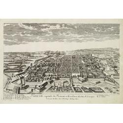
Turin ville capitale du Piémont, et Résidence du Duc de Savoye. . .
A very decorative and rareof Turin, including a numbered key (A-M) in lower part. Engraved by Pierre-Alexandre Aveline. With "fait par Aveline avec privilege du Roy ...
Date: Paris, ca.1692

Die Zyp / La Zype.
A miniature map showing the polder of De Zype. Title cartouche in the upper side.First published in 1598 in his Caert-Thresoor, the plates were executed by the most famou...
Date: Amsterdam / Frankfurt, 1609

III. Carte de la Hollande.. Over-Yssel.
Attractive small map centered on the delta of the River Ijssel, where it discharges into the Zuiderzee.From Atlas Portatif Universel, by Robert de Vaugondy. Unrecorded st...
Date: Paris, later than 1748

Carinthiae et Goritiae... / Histria tabula.../ Zarae, et Serebenici ..
Three maps on one sheet. The left hand is centered on the eastern part of Austria. The right upper hand map is centered on northern Yugoslavia, and the last map is center...
Date: Antwerp, 1598

Cajanie, ou Bothnie Orientale Tirée de celles d'Andr Burae et de Isaac Massa. . .
Map of the Northern part of Gulf of Bothnia, today's border area between Sweden and Finland. The map derive from the work of the Swedish cartographer Andreas Bureus and I...
Date: Paris, P.Mariette, 1666

Carte des Isles de Maiorque Minorque et Yvice dediée A.M. le Comte de Maurepas Ministre et secretaire d'Etat. . .
Fine map of the Baleares with much detail, in lower part inset "Plan du Port de Mahon du Fort St. Philippe et ses Fortifications". The map is dedicated to Jean ...
Date: Amsterdam, after 1740

Norimberga.
A spectacular panoramic town-view of Nuremberg, with legends numbered from 1-39 in German. With the title in a banderol.After a design by Friedrich Bernhard Werner (1690...
Date: Augsburg, ca. 1720
![Flandra parte occidentale: dedicata all'illustrissimo et eccelententissimo S. Giorgio Cocco, senatore meritissimo. . . [together with] Zelanda e Parte Orientale della Flandra. . . .](/uploads/cache/31286-250x250.jpg)
Flandra parte occidentale: dedicata all'illustrissimo et eccelententissimo S. Giorgio Cocco, senatore meritissimo. . . [together with] Zelanda e Parte Orientale della Flandra. . . .
Wall sized map of two joined sheets of Flanders, the coastline running from Calais to Zeeland in the Netherlands. Including major cities along the coast such as Dunkerque...
Date: Venice, 1696
![.[Georgia (Republic), Sarmatia, Ukraine]](/uploads/cache/33870-250x250.jpg)
.[Georgia (Republic), Sarmatia, Ukraine]
Wood block printed map and one of earliest printed representation of Georgia (Republic), Sarmatia, Ukraine prepared by Martin Waldseemüller. Based on the slightly larger ...
Date: Vienna, Trechsel, G., 1525 -1541

Madrid.
Extremely rare town-view of Madrid. Engraved by Francesco Ambrosi.With a second title in lower part "Madrid Ciudad Capital Del Reyno D'Espana y real corte de los rey...
Date: Bassano del Grappa, c.1780

La Basilica Vaticana consacrata al Principe de gli Apostoli . . .
Monumental engraving showing the Papal Basilica of St. Peter in the Vatican, in its setting, with below a coat of arms with dedication to Cardinal Sigismondo Chigi. Obili...
Date: Rome, 1693
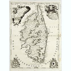
Isola di Corsica, Dedicata all' Em;mo e Rmo: Principe, il Sr. Cardinale Carpegna, Vicario di Sua Santita. . .
One of the most decorative maps of Corsica, with in the upper right, a draped fabric that bears the map's scales is dressed with two angels, one holding the cross, a coat...
Date: Venise, 1692

VI. Partie du Duche de Gueldre où se trouve la Veluwe.
Attractive small map covering the northwestern part of Gelderland. In the center "'t Loo". From Atlas Portatif Universel, by Robert de Vaugondy.Unrecorded state...
Date: Paris, later than 1748

Hongarije.
Poster made for Hungarian Tourist association. The uncommon Dutch version of this fine poster to promote Hungary in the 1930's. Arisztid Uher was a graphic designer. He d...
Date: Budapest, KLOSZ / Sohn., ca. 1930

Biturigum.
A miniature map of the Berry. Fine cartouche in the upper left corner.First published in 1598 in his Caert-Thresoor, the plates were executed by the most famous engravers...
Date: Amsterdam/Frankfurt 1609

Vue du Magazin de la Compagnie des Indes Orientales. . .
So-called optical print of the formerly the V.O.C. warehouse and arsenal for the Admiralty of Amsterdam, now-a-days the Scheepvaartmuseum (Maritime Museum).In the eightee...
Date: France, 1780

Florentini Dominii Fidelissima et nova descriptio.
The map is centered on the city of Florence and extends to Liguria, the Apennine Mountains, the Adriatic Coast, Siena and Lago di Perugia. The map is based upon Stefano B...
Date: Anvers, 1598

Coloniensis Archiepisscopatus.
Extremely rare first edition of this beautiful map of Cologne and Dusseldorff.Jodocus Hondius Jr. planned to produce a new modern atlas less dependent on the Mercator pla...
Date: Amsterdam, 1629

U.R.S.S. Energie Eléctrique. (5)
Map of Russia. Publicity poster for Russia's electrical production. Text in French. Editions de l'Agence de presse Novosti".More about War Maps & Propaganda maps...
Date: USSR, 1978

Nova et Accurata totius EUROPAE Descriptio Authore Frederico de Wit Amstelodami.
General map of Europe richly ornamented with small compass rose and Europa shown riding Zeus in the form of a bull, and several putti holding the title banner aloft.
Date: Amsterdam, 1680
![[ Manuscript map of the Ligurian coast from Pietra to Genova ].](/uploads/cache/26627-250x250.jpg)
[ Manuscript map of the Ligurian coast from Pietra to Genova ].
Very detailed French manuscript map of the Ligurian coast from Pietra and Finale, Savone to Genoa with the Maritime Alps in the background. The Liguria coast borders to n...
Date: France, ca. 1790-1800

La marca d'Ancona. Marchia Anconitana Picaenum olim dicta. . . Romae apud Joannem Orlandini formis Rome 1604.
A re-issue of the plate by Vicentium Luchinù of 1564 now with the address of Orlandini and the dates 1602 / 1604.A unique opportunity to acquire a fine example of a map f...
Date: Rome, 1604
![Basilae [ Basle, CCXLIIII ]](/uploads/cache/29714-250x250.jpg)
Basilae [ Basle, CCXLIIII ]
A very fine view of Basle (253x520 cm). Verso showing the councils of Florence and Basle and two portraits.Page from the richest illustrated Incunabel, the famous Nurembe...
Date: Nuremberg, 12 July 1493

Carte particulière des environs de St Peters-bourg. . . / Plan de la ville faubourg et environs de St Petersbourg. . . / Carte pour l'intelligence de la guerre de Moscovie et de Suede. . .
A scarce and unusual plan of Saint Petersburg shown at a large scale and also, in a separate compartment, shown in its geographical context between the Gulf of Finland an...
Date: Paris, c.1741

Fossa Sanctae Mariae.
Detailed map of part of the country between rivers Rhine and Meuse showing a canal to be dug between 1626 and 1628 between Rheinberg in Germany and Venlo. A deficiency of...
Date: Amsterdam, 1645

IX. Die Lepontier.
Very early wood cut printed regional map of Switzerland.Originally engraved in 1548. The map was prepared by Johannes Stumpf (1500-1576). Included in "Landtaflen. Hi...
Date: Zurich, Christoffel Froschover, 1548,1552-1566

Map of Russia and Poland.
Charming, folding map of Russia, Poland and Baltic States, still in its original publisher's blind stamped linen wrapper with yellow label. With yellow advertisements at ...
Date: London, ca. 1894
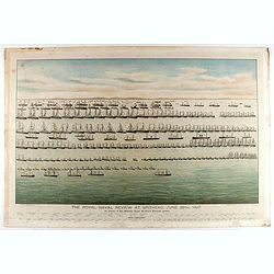
The Royal Naval review at Spithead, June 26th, 1897. In Honour of Her Majesty Queen Victoria's Diamond Jubilee.
A very decorative and large chromolithographed plate showing a line up of international vessels at Spithead, June 26th, 1897 In Honour of her Majesty Queen Victoria'a Dia...
Date: Portsea, ca. 1897

Riga metropolis Livoniae.
A spectacular panoramic view of Riga, with legends numbered from a-z and 1-16 in German. With the title in a banderol.After a design by Friedrich Bernhard Werner (1690-1...
Date: Augsburg, ca. 1720

Le Duché d'Aiguillon Tracé Par le Sr. Du Vall.
Home of the "Cahors” This AOC is the most famous of the sub-regions and home to the popular variety Malbec. These inky wines have been adored for centuries, especial...
Date: Amsterdam, 1650

Comitatus Zutphania.
A very detailed map of this area, including Arnhem, Nijmegen, Zutphen, Groenlo, etc. First imprint, from a Latin edition of the scarce Atlas Appendix.
Date: Amsterdam, 1637

Vue de Malthe du cote du Fort.
A so-called optical print of Valletta seen from the castle. This rare optical print shows people in typical French dresses in the foreground and placed in boats.In the ei...
Date: Paris, 1798

Province de Pologne contenant 22 Col. une M.on Prof 5 Pen. 2 Nov. 6 Rés. 30 Maisons 1050 Jésuites.
Rare map of Poland from "Atlas Universel indiquant les établissemens des Jésuites: avec la manière dont ils divisent la terre, suivi desévénemens remarquables de leu...
Date: Paris, Ambroise Dupont , 1826

IWAN ALEXEJEWITSCH - Ioann Alexejewitsch zar i camoderschez wserossinskij (rossice).Joann Alexiewicz tzaar et autocrator totius Russiae.
Extremely rare print of Czar Ivan Alexejewitsch, who was the brother of Peter the Great.Johann Stenglin was a well known engraver, born at Augsburg in 1715, he studied un...
Date: St. Petersburg 1743

Dominio Veneto nell' Italia.
With the Gulf of Venice. Including the towns of Cremona, Brescia, Venice, etc.As Willem Blaeu died in 1638 most of his maps are actually published by his son Joan. This m...
Date: Amsterdam, 1638

Ignographia candiae tertia a turcis obsessae in lucem edita a F. de Wit.
A scarce broadsheet plan and view of Heraklion on one sheet: prospect 180 x 495mm, map 395 x 495mm., in the lower part a printed description "Abbildung der starken S...
Date: Amsterdam, 1680
![[ The repositioning of the Vatican obelisk ]](/uploads/cache/49045-250x250.jpg)
[ The repositioning of the Vatican obelisk ]
Joan Blaeu published The Repositioning of the Vatican Obelisk. This large engraving on multiple sheets and in beautiful original colors is based on Domenico Fontana’s dra...
Date: Amsterdam, 1649

Pascaerte Van't Westelyckste der Middelandsche Zee. . .
An eye-catching chart of the western part of the Mediterranean Sea.Pieter Goos (ca. 1616-1675) was one of the most important cartographer, engraver, publisher and print s...
Date: Amsterdam, 1666
![Tabula electoratus Brandenburgici, Meckelenburgi, et maximae partis Pomeraniae, ex variis, famosissimisq[ue] auctoribus summo studio concinnata. . .](/uploads/cache/29543-250x250.jpg)
Tabula electoratus Brandenburgici, Meckelenburgi, et maximae partis Pomeraniae, ex variis, famosissimisq[ue] auctoribus summo studio concinnata. . .
Uncommon "carte à figures"- map engraved by the master engraver Abraham Goos and published by Claes Jansz. Visscher (1587-1652). Showing the area of Brandenburg...
Date: Amsterdam, 1630

Paskaert vande Bocht van Vranckrijck Biscajen. . .
An eye-catching chart of the coast of Bretagne from Brest running south till the coast of Biscay in Northern Spain.Including the towns of Ferrol in the west, Gijon, Santa...
Date: Amsterdam, after 1666

Wittstocs.
Very decorative and rare panoramic of Wittstock, Bez. Potsdam.The engraver and publisher of prints, Mrs. Anna Beek of the Hague, enlarged the print and mounted it on larg...
Date: The Hague, ca. 1642

Strasborcs In der Vocker Marckt.
Very decorative and rare panoramic town view of Völckermarckt in Kärten.The engraver and publisher of prints, Mrs. Anna Beek of the Hague, enlarged the print and mounted ...
Date: The Hague, ca. 1642

EUROP, and the cheife Cities contayned therin described. . .
A good impression from an early edition of this famous and decorative "carte à figures"- map from the first world atlas produced by an Englishman - John Speed's...
Date: London, 1627 - 1676

Plan de la Ville et Port d'Antibes.
An attractive chart centered on the Mediterranean. With a scale and large compass-rose. Dated 1727, with the privilege of the King. From : Recueil des Plusieurs plans des...
Date: Marseille, 1730
![[West Central London from Booth's Poverty Map of London]](/uploads/cache/40267-250x250.jpg)
[West Central London from Booth's Poverty Map of London]
A map of West Central London, one section (of twenty) of an extended version of the incredibly influential Poverty Map, originally published in Charles Booth's 'Life and ...
Date: London, 1900

Daniae regni typum . . .
Second Edition, now for the first time with a date (1630), this rare map which - like that of Janssonius-Kaerius - is based on John Speed's map of 1626. The side borders ...
Date: Amsterdam, 1630

Vue de Gattweick et de l'embouchure du Rhin, dans la Mer du Nord.
Very decorative view of Katwijk. Signed lower right, Louis Bleuler au chateau de Laufen . Original design by Louis Bleuer. This gouache was the model for his aquatint in ...
Date: 1820

Polonia regnum et Silesia ducatus.
Very decorative map of Poland embellished with two cartouches and two coats of arms surmounted by cherubs and female figures. Showing the region from the Oder east to Pod...
Date: Amsterdam, 1638

The Crimea, chiefly from surveys made by order of the Russian government. . .
Map of Crimea and the Sea of Azov. In lower right corner two inset maps showing Sebastopol inlet and harbour and a second one with the Black Sea. This second maps shows t...
Date: London, 1854
![Praga. [Prague]](/uploads/cache/28442-250x250.jpg)
Praga. [Prague]
A rare panoramic of Prague with over the whole length of the lower part 3 columns of poems in Latin, Dutch and French and a numbered key 1-34 to the principal buildings ...
Date: Amsterdam, 1660

Royaume de Bohéme, Marquisat de Moravie, et Silésie Autrichenne.
Small detailed map of today Czech Republic. From Atlas Portatif Universel, by Robert de Vaugondy.Unrecorded state with erased date. Page 32 outside border top right. Mary...
Date: Paris, later than 1749

Veue de la Ville, et du Port de Calais, di côte de la terre.
Showing the town of Calais; landscape with, in the left foreground, group of cavalrymen led by an officer and going to right, at right two soldiers walking alongside a ca...
Date: Paris, ca. 1680

39e Vüe d'Optique Representant L'Hotel du Lord Maire de Londre.
So-called optical print illustrating a perspective view of Somerset House on the Strand in London.In the eighteenth and nineteenth centuries, many popular specialty estab...
Date: Paris, 1760
