Popular Listings in Europe

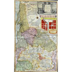
Silesiae typus..
Fine and early map of Silesia after Martin Helwig (1516-1574) and used by A.Ortelius in his atlas 'Theatrum Orbis Terrarum [Atlas of the Whole World].Only included in the...
Date: Antwerp, 1598

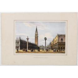
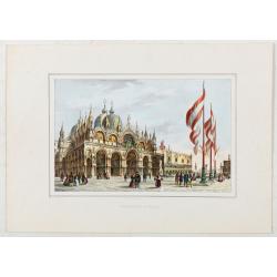
La Place de Saint Marc a Venise.
A very attractive Town plan of the place St Marc in Venice.Joan Blaeu published during his life three town books of Italy: Citta del Vaticano, Rome, and Napoli. By the ye...
Date: Amsterdam, 1705
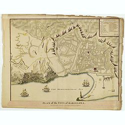
Plan of the City of Barcelona.
From Rapin's History of England , a nicely detailed plan of Barcelona, the capital of Catalonia. The plate contains a 19 point legend and the presentation is enhanced wit...
Date: London, c.1745
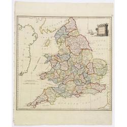
Present Britain.
A fully colored map of England and Wales from An Universal Atlas Consisting of a Complete Set of Maps, peculiarly adapted to illustrate and explain ancient and modern geo...
Date: London, 1797

II Regno di Francia Diviso in Provincie e Governi ove su`Le Frontiere di esso Rappresenta il Teatro della Guerre di Flandria Germania Savoja e Lombardia.
Very rare wall map of France depicting "The Kingdom of France divided into Provinces and Governments with on its borders the Theater of War of Flanders, Germany, Sav...
Date: Naples, 1704
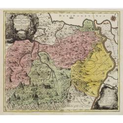
Pagus Helvetiae Abbatiscellanus .. Valle Rhenana. . .
Scarce. A splendid map of the Swiss Alps, the area south west of the Boden See and west of the River Rhine, centered on Appenzell, St. Gallen. Engraved by Tobias C. Lotte...
Date: Augsbourg, 1760

Schlavoniae, Croatiae, Carniale.. Bosniae. . .
First state. Fine and early map of former Yugoslavia after a map of Hirschvogel (1552-1565) and used by A.Ortelius in his atlas 'Theatrum Orbis Terrarum [Atlas of the Who...
Date: Antwerp, 1579
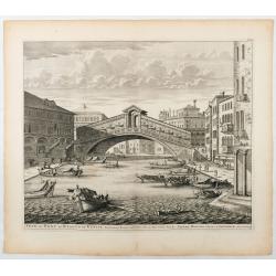
Veue du Pont de Rialto de Venise.
Spectaculair view of Rialto bridge in Venice. Joan Blaeu published during his life three town-books of Italy: Citta del Vaticano, Roma and Napoli. By the year 1672 a fire...
Date: Amsterdam, 1705
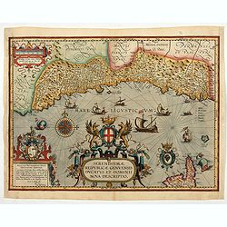
Serenissimae Reipublicae Genuensis Ducatus et Dominii.
Includes the coast of the Riviera from Nice to La Spezia. A most decorative and rare map because it was only included in the Vrients' editions of the Ortelius Theatrum . ...
Date: Antwerp, 1609-1641
Petite Place de S. Marc.
View of St Mark’s Square, lithographed in Venice by G. Brizeghel, published here with French captions in "Album delle principali vedute di Venezia". In origina...
Date: Venice, c.1855
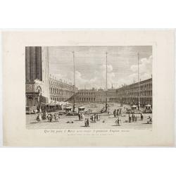
Qua late patet S. Marci area major novum Regim Palatium versus.
Qua late patet S. Marci area major novum Regim Palatium versus". View of piazza San Marco, the church of San Geminiano at the far end, figures and market stalls in t...
Date: Venice, 1763
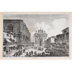
Aedis Divi Rocchi facies rudis…
The Campo San Rocco. Title centred in the lower margin; “Mich. Marieschi del.t et inci.t” at the right corner of the cartouche. From the series "Magnificentiores Sel...
Date: Venice, c. 1742
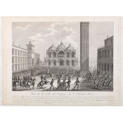
Prise de la ville de Venise le 3 floréal an 5.
Capture of the City of Venice on 3 Floréal, Year V", engraved by Pierre-Adrien Le Beau after Thomas-Charles Naudet. Deposited at the Bibliothèque nationale.During th...
Date: Paris, chez Jean, c. 1798

Prospectus Plateae ad Divum Iacobum de Rivoalto ubi Mercatores conveniunt.
Prospectus Plateae ad Divum Iacobum de Rivoalto ubi Mercatores conveniunt. From the series "Prospectum Urbis Venetiarum" (Views of Venice). Published by Lodovic...
Date: Venice, c. 1763
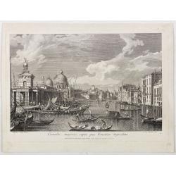
Pars Canalis Magni De Extendens A Laeva…
The Cannaregio on the Grand Canal, with the Ghetto in the background, seen from the Riva di Biasio. From the series "Magnificentiores Selectioresque Urbis Venetiarum...
Date: Venice, after 1757
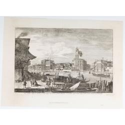
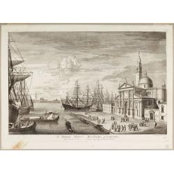
Canalis majoris caput qua Venetias ingreditur.
Canalis majoris caput qua Venetias ingreditur". A view of the Grand Canal with Santa Maria della Salute to the left after Canaletto.From the series of 12 views entit...
Date: Venice, c. 1766
Veduta della Magnifica REGATA seguita in Venezia li 2. Aprile 1791 alla quale intervennero li Augusti Viaggiator.
Decorative engraving of a Venice regatta on the Grand Canal, by Teodoro Viero (1740-1819) after a paining by Canaletto.The tradition of Venetian origin of the race is lin...
Date: Venice, c. 1791
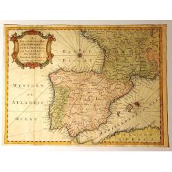
A New and Accurate Map of the Kingdoms of Spain, Portugal and Part of France, The Islands of Majorca, Minorca &c.
Produced for “Universal Magazine” by J. Hinton. It was engraved by Richard William Seale (1703-1762). The map features an attractive rococo cartouche and compass rose wi...
Date: London, ca. 1760
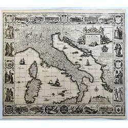
Tabulae Italiae, Corsicae, Sardiniae, et adjacentium..
A decorative map by this famous Dutch mapmaker. The border contains views of the main cities, largely inspired by the Civitates Orbis Terrarum by Braun & Hogenberg: R...
Date: Amsterdam, 1628,1640
Estat De La Seigneurie De Venize en Italie.
Map of The Venetian Dominion inspired by the map of Jodocus Hondius. Published "A Paris Chez Pierre Marietti (sic), Rue Sainct Jacques A l'esperance". Decorated...
Date: Paris, ca. 1670
![[Lot of 6 leaves] Civitas Augustana olim Vindelica…/Sueviae et Bavariae Descriptio/ Franckfordiae ad Oderam imago…/Franckofordianae civitatis…/Erdfordia magnifica …Thuringoru urbs…Fuldensis civitatis… / Lubecum una ex praeclarioribus. . .](/uploads/cache/48258-250x250.jpg)
[Lot of 6 leaves] Civitas Augustana olim Vindelica…/Sueviae et Bavariae Descriptio/ Franckfordiae ad Oderam imago…/Franckofordianae civitatis…/Erdfordia magnifica …Thuringoru urbs…Fuldensis civitatis… / Lubecum una ex praeclarioribus. . .
1522 MÜNSTER, S. - Six text leaves with wood block printed views and maps of Augsburg, Frankfurt /Oder, Frankfurt am Main, Erfurt and Fulda, Lübeck and a map of Swabia a...
Date: Basel, 1552
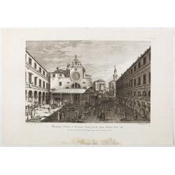
Prospectus Plateae et Ecclesiae Sancti Jacobi prope Pontem Rivi alti.
Prospectus Plateae et Ecclesiae Sancti Jacobi prope Pontem Rivi alti". The Church of San Giacomo di Rialto, at right Palazzo dei Dieci and the bridge of Rialto.From ...
Date: Venice, c. 1763
Basilique S. Marc.
St Mark’s Basilica, lithographed in Venice by G. Brizeghel, published here with French captions in "Album delle principali vedute di Venezia". In original colo...
Date: Venice, c.1855
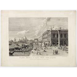
A publica Bibliotheca ad majoris Canalis initium prospectus.
A publica Bibliotheca ad majoris Canalis initium prospectus". View of the Biblioteca Nazionale Marciana, the column of San Teodoro at right, at left the Grand Canal,...
Date: Venice, 1763
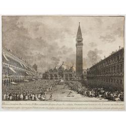
Habita a Serenissimo Duce in Basilica D.Marci ad populum allocutione…
Habita a Serenissimo Duce in Basilica D.Marci ad populum allocutione, ab eoque Dux salutatus, Armamentariorum humeris in sella gestatoria cum duobus proxime consanguineis...
Date: Venice, c. 1766-1770
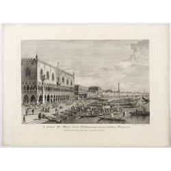
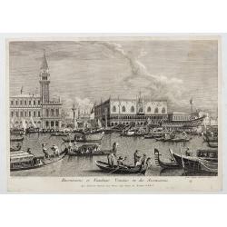
A minore D: Marci Area Dalmatarum ripam.
A minore D: Marci Area Dalmatarum ripam". View of the Riva degli Schiavoni from the east including the Palazzo Ducale in the foreground. Apud Ludovicum Furlanetto su...
Date: Venice, c. 1763
S. Georgii Majoris Ecclesiae prospectus.
S. Georgii Majoris Ecclesiae prospectus". S. Giorgio with the church and quay in sharp perspective.From the series "Prospectum Urbis Venetiarum" (Views of ...
Date: Venice, ca. 1791
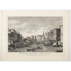
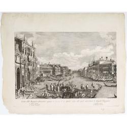
Pons Rivoalti, utriumqque Ripae, et Aedes ad Orientem.
Pons Rivoalti, utriumqque Ripae, et Aedes ad Orientem." From the series "Prospectum Urbis Venetiarum" (Views of Venice). 1st state. Published by Lodovico F...
Date: Venice, 1763
Canalis majoris caput qua Venetias ingreditur.
Bucentaurus et Nundinae Venetae in die Ascensionis". The Doge leaving for the Lido on the Bucintoro on Ascension Day.From the series of 12 views entitled Feste Ducal...
Date: Venice, c. 1766
![Ornithon sive Aviarum M. Varronis Pyrro.Ligorio.Neap.inv. [The reconstruction by Pirro Ligorio of the aviary of Marcus Varro].](/uploads/cache/49261-250x250.jpg)
Ornithon sive Aviarum M. Varronis Pyrro.Ligorio.Neap.inv. [The reconstruction by Pirro Ligorio of the aviary of Marcus Varro].
The print, depicting the reconstruction by Pirro Ligorio of the aviary of Marcus Varro in Rome, was printed by Giovanni Orlandi in 1602 from a copperplate originally eng...
Date: Rome, 1581-1602

Itinera Varia Auctoris.
From A Natural History of Uncommon Birds, and of some other rare and undescribed Animals, Quadrupeds, Reptiles, fishes, insects, &c.. The map shows Edwards' journeys ...
Date: London, 1746
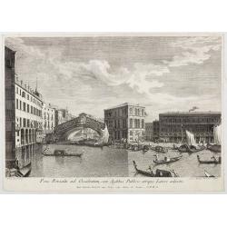
Pons Rivoalti ad Occidentem, cum Aedibus Publicis utrique Lateri adjectis.
Pons Rivoalti ad Occidentem, cum Aedibus Publicis utrique Lateri adjectis."From the series "Prospectum Urbis Venetiarum" (Views of Venice). 1st state. Publ...
Date: Venice, 1763
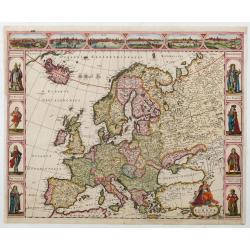
Nova Europae descriptio.
Four panels in columns on each side show portraits of the kings and Queens of European countries. The top border contains panoramas of Rome, Amsterdam, Paris, London, Sev...
Date: Amsterdam, c. 1660
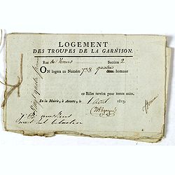
Logement des troupes de la garnison. . .
Seven coupons "Logement des troupes de la garnison ce billet servira pour trente nuits" giving a soldier the right for housing at 738 Rue de Venus in Antwerp in...
Date: Antwerp, 1813
![Venditori di pesci (Anguele). Marchands de petite poissons. [Fish Sellers of Venice]](/uploads/cache/49430-250x250.jpg)
Venditori di pesci (Anguele). Marchands de petite poissons. [Fish Sellers of Venice]
Small Fish Sellers. From a series of lithographs depicting various Venetian trades, published in Venice by Galvani. Subjects include genre figures such as fishmongers, ch...
Date: Venice, c. 1835
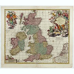
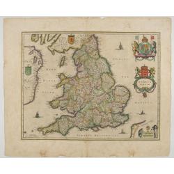
Magnae Britaniae Tabula; Comprehendens Angliae, Scotiae, Ac Hiberniae Regna . . .
Rare Dutch map of the British Isles in very attractive full original color. In this state the wording "Scilly Isles" is added. A decorative title cartouche in t...
Date: Amsterdam, after 1694
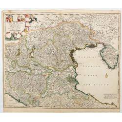
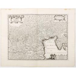
Accuratissima Dominii Veneti in Italia..
Detailed and decorative map centered on Venice, Vicenze, Mantova, Parma and Bologna, extending from Stato di Milano and Genoa to Istria. Decorative title cartouche in upp...
Date: Amsterdam, c. 1690

Walachia Servia, Bulgaria, Romania.
The cartographer of this map was Gerard Mercator. This attractive map of the Eastern Balkans is centered on Bulgaria and includes the Bosphorus and Constantinople. The Da...
Date: Oxford, 1680
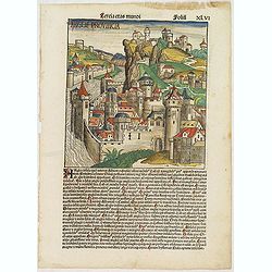
Tercia Etas Mundi. Folium.XLVI (An English town view)
Large woodcut depicting an imaginary English town (235x223mm.) and on the verso the genealogy of King David.Page from the richest illustrated Incunable, the famous: Chron...
Date: Nuremberg, 12 July 1493

Russia & Poland.
Charming, folding map of Russia and Poland, giving a detailed overview of Europe from Baltic to Caspian Sea. Railways and rivers prominently delineated.In lower left a ke...
Date: London, ca. 1890

Tabula Secunda Europe (Spain & Portugal)
Wood block printed large-format Ptolemaic map of the Iberian Peninsula from the 1513 edition of Waldseemüller's Geographia.This Ptolemaic map comes from the first so call...
Date: Strasburg, 1513
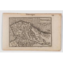
Norwegia.
An attractive and important miniature map Norway. The map is orientated to the west. The earliest map showing Norway.Prepared by Petrus Bertius, published in Amsterdam at...
Date: Amsterdam, 1606
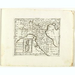
L'Italia Settentrionale presa da quella del Sig. Zannoni.
Rare map of Italy with inset map with Corsica and Sardinia, from "Atlante Novissimo ad uso Dei Giovani Studiosi Contenuto In Carte XXVII.", published by Giovann...
Date: Rome, 1780
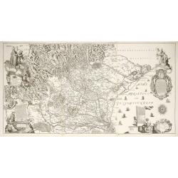
Diocesi Padovana Con Tutta La Sua Estensione Ne Vicini Territori.
This large map depicts the entire extent of the Diocese of Padua and the surrounding territories, with a detailed topographical rendering. It features rich Baroque ornam...
Date: Padova, 1720
Potentissimo Borussorum Regi Friderico Wilhelmo...
Large and sought-after 2-sheet map of an area of Lithuania and Eastern Prussia (Russian province of Kaliningrad) stretching from Klaipeda (Memel) in the north to Goldap i...
Date: Nuremberg, 1735
![Baltick or East Sea]](/uploads/cache/49464-250x250.jpg)
Baltick or East Sea]
A Chart of the Baltic or East Sea. Gulf of Finland & c. (date ca.1730). Image size: 357mm x 283mm.Herman Moll (1678-1732) was a German emigre from the Hanseatic port...
Date: London, ca. 1720-1730
Anglia Regnum.
Janssonius' map of England and Wales was one of the new maps prepared by him in 1636. His map closely copies the similar map issued two years earlier by Willem Blaeu.. Th...
Date: Amsterdam, 1642
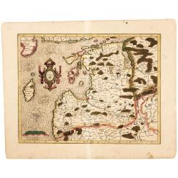
Latvia/ Estonia. Livonia.
A beautifully engraved map of Livonia – modern Latvia and Estonia – produced by two of the great fathers of modern cartography. Included are parts of the Baltic coasts of...
Date: Amsterdam, 1595-1609
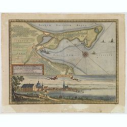
Neoburgum Fioniae oppidum. . .
Decorative plan and panoramic view of the town of Nyborg in Denmark at the coast of Baltic Sea in Fyn. Prepared by Count Erik Jönsson Dahlberg[h] (1625-1703). Military en...
Date: Stockholm, 1697
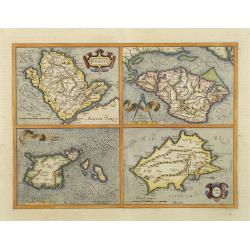
Anglesey. / Iarsay. / Carnesay. / Wight Vectis Olim.
Four maps on one sheet depicting the English islands Jersey, Guernsey, Wright and Alderney.
Date: Amsterdam, 1629
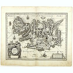
Tabula Islandiae. . .
With a very decorative cartouche and a very fine imprint. No text on verso; included in the rare "Appendix" of 1630. VERY RARE. This handsome map of Iceland was...
Date: Amsterdam, 1630
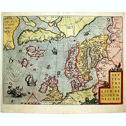
Septentrionalium Regionum Descrip.
1584 ORTELIUS, A. - Scandinavia, Iceland, Greenland and part of the North American continent, includes also the legendary islands of i.a. Drogeo, Frisland and Icaria.
Date: Antwerp, 1584
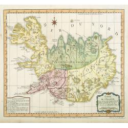
Carte de l'Islande pour servir á la continuation de l'histoire générale des voyages. Dressée sur celle de M. Horrebows.
A good engraved map of the island Iceland, prepared by Bellin after M. Horrebows, with rococo title cartouche in lower right. From l'Histoire générale des voyages.
Date: Paris, 1758
