Browse Listings
![[ Original Chinese advertising poster for ] Coat Clark British company.](/uploads/cache/45079-250x250.jpg)
[ Original Chinese advertising poster for ] Coat Clark British company.
This poster, an advertisement for Coat Clark British company from the 1930s, melds the meticulous detail of traditional Chinese painting with the craft of color lithograp...
- $300 / ≈ €260
Date: Shanghai, 1934
![[ Original Chinese advertising poster for ] [Google translate: Vendor Yiwei Shikou Supervisor Store Baishun Chengyan]](/uploads/cache/45082-250x250.jpg)
[ Original Chinese advertising poster for ] [Google translate: Vendor Yiwei Shikou Supervisor Store Baishun Chengyan]
This poster, an advertisement from the 1930s, melds the meticulous detail of traditional Chinese painting with the craft of color lithography. It depicts a beautiful woma...
- $300 / ≈ €260
Date: Shanghai, 1934
![[ Original Chinese advertising poster for ] [Google translate: The picture of Hong tao Carpet garden]](/uploads/cache/45083-250x250.jpg)
[ Original Chinese advertising poster for ] [Google translate: The picture of Hong tao Carpet garden]
This poster, an advertisement from the 1930s, melds the meticulous detail of traditional Chinese painting. It depicts a young woman posing. Google translate: "Americ...
- $300 / ≈ €260
Date: Shanghai, 1934
![[ Original Chinese advertising poster ]](/uploads/cache/45086-250x250.jpg)
[ Original Chinese advertising poster ]
This poster, an advertisement from the 1930s, melds the meticulous detail of traditional Chinese painting with the craft of color lithography. It depicts a young woman dr...
- $300 / ≈ €260
Date: Shanghai, 1934
![Mer Adriatique. Partie Sud.. [3976]](/uploads/cache/23549-250x250.jpg)
Mer Adriatique. Partie Sud.. [3976]
This large scale coastal chart centered on the southern part of the Adriatic sea. Showing the Dalmatian coast between Split in Croatia as far as the northernmost tip of C...
- $200 / ≈ €173
Date: Paris [1883] updated for 1935
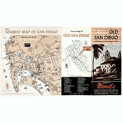
Welcome to old San Diego, birthplace of California 1769.
Publicity leaflet for "Manuel's Restauranté" in the Casa de Pedrorena. On one side a pictorial map of San Diego and "Tourist Map of Old San Diego", w...
- $75 / ≈ €65
Date: San Diego, ca. 1935
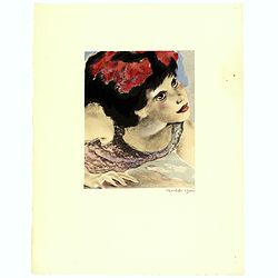
Dessins de Mariette Lydis pour illustrer les Fleurs du Mal. (PL X. Le Vampire)
"Le Vampire" - Etching enhanced with watercolors and signed in pencil by Mariette Lydis, to illustrate Baudelaire's poems of "Les Fleurs du Mal".Govo...
Date: Paris, G.Govane, 1928/1935
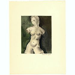
Dessins de Mariette Lydis pour illustrer les Fleurs du Mal. (PL VIII)
Etching enhanced with watercolors and signed in pencil by Mariette Lydis, to illustrate Baudelaire's poems of "Les Fleurs du Mal".Govone printed 353 copies of h...
- $45 / ≈ €39
Date: Paris, G.Govane, 1928/1935
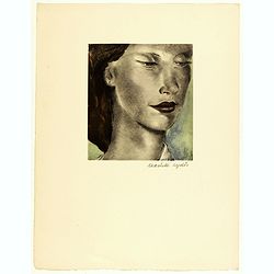
Dessins de Mariette Lydis pour illustrer les Fleurs du Mal. (PL IV. La Beauté)
"La Beauté" - Etching enhanced with watercolors and signed in pencil by Mariette Lydis, to illustrate Baudelaire's poems of "Les Fleurs du Mal".Govo...
- $45 / ≈ €39
Date: Paris, G.Govane, 1928/1935

Favor, Chocolat très fin de Favarger.
Original advertising poster for the Swiss chocolate brand Favor, and printed by Fiedler, la Chaux-de-Fonds.Read more about Poster History [+]
- $450 / ≈ €389
Date: France, ca. 1935
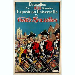
Bruxelles Avril Novembre 1935 Exposition Universelle Le Vieux Bruxelles.
Advertising poster for the Universal Exhibition "Old Brussels" of 1935 April - November , made by Thiriar James and printed by Ets. Gen. D'Imp., in Belgium.Thir...
- $400 / ≈ €346
Date: Brussels, 1935
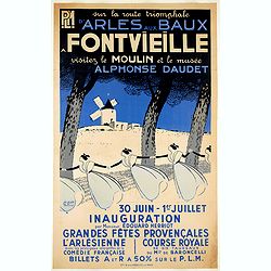
Sur la route triomphante d'Arles aux Baux - A Fontvieille visitez le moulin et le musée Alphonse Daudet.
Advertising poster for PLM created by the French artist Léo Lelée . " Sur la route triomphante d'Arles aux Baux " . " A Fontvieille visitez le moulin et ...
- $900 / ≈ €779
Date: Paris, G. de la Vasselais, 1935
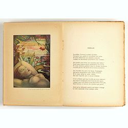
Les Fleurs du Mal by Charles Baudelaire ( Laboccetta )
Sought-after edition of the famous poems of the great French writer, in the called definitive, posthumous edition of 1868, to which the censored titles have been added. I...
- $250 / ≈ €216
Date: Paris, Gründ, 1935
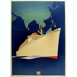
Poster, rare state before text . HAPAG
Original art deco cruise ship travel poster promoting HAPAG Line to Colombo, Singapore, Manilla, Hong Kong, Shanghai, Kobe and Yokohama. Great illustration by the German ...
- $1250 / ≈ €1082
Date: Hamburg, ca. 1935
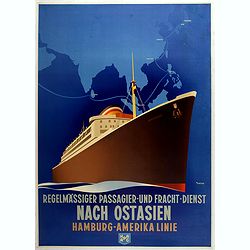
Regelmässiger passagier - und - fracht - dienst nach Ostasien Hamburg - Amerika Linie. (HAPAG)
Original art deco cruise ship travel poster promoting HAPAG Line to Colombo, Singapore, Manilla, Hong Kong, Shanghai, Kobe and Yokohama. Great illustration by the German ...
- $1900 / ≈ €1644
Date: Hamburg, ca. 1935
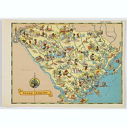
South Carolina.
A fun, humorous, whimsical map of South Carolina by Ruth Taylor White. With vibrant colors.The state is filled with delightful cartoonish characters, some pursuing assort...
- $125 / ≈ €108
Date: Boston, ca 1935
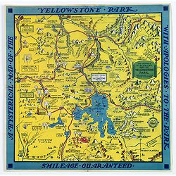
The Famous Hysterical Map of Yellowstone Park, including a few minor Changes.
A lovely whimsical map of America's Yellowstone Park, published about the time of President Franklin Roosevelt's "New Deal" for America in 1936. To emphasise th...
Date: America, ca 1936
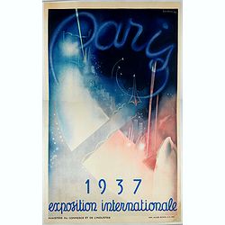
Paris 1937 - Exposition Internationale
Promoting poster for the International Exhibition of Arts and Techniques in Paris in 1937, made by Beaudoin - Lods and printed by Imp. Jules Simon. S.A. Paris, on behalf ...
- $850 / ≈ €736
Date: Paris, 1937
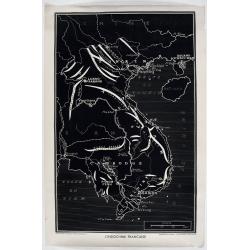
l'Indochine Française
Map of Indochina published ca 1937 by Fernand Nathan, a well-known publisher of school books, maps and material for teaching geography.
Date: Paris, ca. 1937
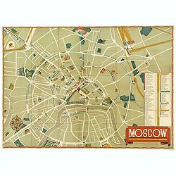
Moscow.
A nice colored lithographic town plan of the Russian capital, in English, published in 1938 in order to promote the U.S.S.R's cultural image overseas during Stalin's term...
- $750 / ≈ €649
Date: Moscow, ca 1938
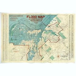
Flood Map of Louisville, KY.
A scarce folding map of the great flood of Louisville, KY, in 1937. The blue coloring highlights the flooded areas of the city, while the red numbers show the depth of th...
Date: Louisville, 1938
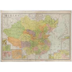
New China Map.
Very large and detailed map of China (1:6,000,000) printed in Shanghai, June 27th 1938 by JIN-SHIN GEOGRAPHICAL INSTITUTE.The title and place names in Chinese and Engli...
- $900 / ≈ €779
Date: Shanghai, June 27th 1938
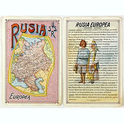
Rusia Europae U.S.S.R.
Detailed map of Russia. Unique manuscript map of Russia. Award-winning manuscript card, prepared by Antonio Raggio for the 11th Congreso de la Union Postal Universal (Wor...
- $450 / ≈ €389
Date: Buenos Aires, 1939
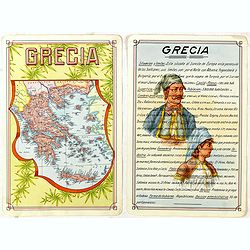
Grecia.
Unique manuscript map of Greece. Award-winning manuscript card, prepared by Antonio Raggio for the 11th Congreso de la Union Postal Universal (World Postal Congress) Expo...
- $250 / ≈ €216
Date: Buenos Aires, 1939
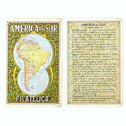
America del Sur Filatelica.
Unique manuscript map of South America. Award-winning manuscript card, prepared by Antonio Raggio for the 11th Congreso de la Union Postal Universal (World Postal Congres...
Date: Buenos Aires, 1939
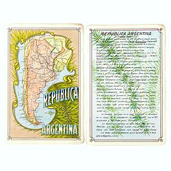
Republica Argentina.
Unique manuscript map of Argentina. Award-winning manuscript card, prepared by Antonio Raggio for the 11th Congreso de la Union Postal Universal (World Postal Congress) E...
Date: Buenos Aires, 1939
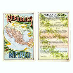
Republica Mejico
Unique manuscript map of Mexico. Award-winning manuscript card, prepared by Antonio Raggio for the 11th Congreso de la Union Postal Universal (World Postal Congress) Expo...
- $200 / ≈ €173
Date: Buenos Aires, 1939
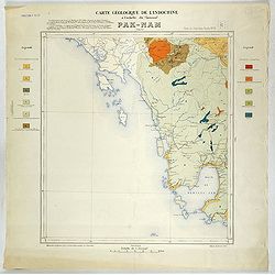
Carte géologique de l'Indochine à l'échelle du 1/500 000e. Pak-Nam Bang-Kok.
Map of Indochina Sheet N ° 16. Covers the area from Paknam (Thailand) to Kompong-Som Bay (Cambodia). On both sides a legend indicates the sedimentary and crystalline lan...
- $130 / ≈ €113
Date: Indo Chine, 1939
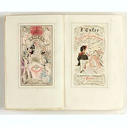
L'enfer de Joseph Prudhomme. Savoir Deux cougnottes et La grisette et l'étudiant. Monnier Henry.
With frontispiece: "In Paris, without the permission of Roy Louis-Philippe". One of the 300 copies printed on Montval vergé (our copy is numbered 68). With 8 e...
- $400 / ≈ €346
Date: Paris, ca. 1939
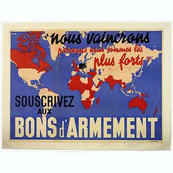
Nous vaincrons parce que nous sommes les plus forts. Souscrivez aux bons d'armement.
We win because we are the strongest. Support good armaments". Quote by the French Prime Minister Paul Reynaud. French wartime propaganda poster. colored world map - ...
- $600 / ≈ €519
Date: Paris ca 1939
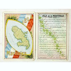
Isla Martinica.
A beautiful hand colored, hand drawn map of the French Caribbean island of Martinique, prepared for the Buenos Aires 1939 Philatelic Exhibition, with separate text with d...
- $100 / ≈ €87
Date: Buenos Aires, 1939
A cartograph of Treasure Island in San Francisco Bay Golden Gate International Exposition.
Ruth Taylor White's large format map of Treasure Island and the San Francisco Golden Gate Exposition Fairgrounds, published in 1940.The map provides an aerial panorama of...
- $200 / ≈ €173
Date: San Francisco, 1940
![Daily Telegraph War Map of The Far East. [No.11]](/uploads/cache/42244-250x250.jpg)
Daily Telegraph War Map of The Far East. [No.11]
A large and very detailed map of The Far East "Specially drawn for the Daily Telegraph by 'Geographia' Ltd". Printed in full color. Map extends from the norther...
- $125 / ≈ €108
Date: London, ca. 1940
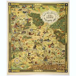
US ZONE. Bavaria, Hesse, Wurtemberg, Baden.
An unusual decorative pictorial map, from the years immediately following World War II, depicting the American Zone of Occupation in southern Germany. It portrays rural ...
- $450 / ≈ €389
Date: Munich, 1940
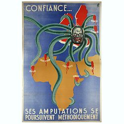
Confiance... Ses Amputations se Poursuivent Methodiquement.
Propaganda poster, produced under the NAZI collaborating Vichy French regime and designed to inspire revulsion and hatred of the English among the French, while frequentl...
Date: Paris, ca. 1941
![[Mussolini Celebrates Pearl Harbor] Grande Carta Del Pacifico](/uploads/cache/48536-250x250.jpg)
[Mussolini Celebrates Pearl Harbor] Grande Carta Del Pacifico
A world map issued four days after the Japanese attack on Pearl Harbor, which led England and the United States to declare war on Japan, this message from Mussolini, cele...
- $500 / ≈ €433
Date: Rome / Milan, 1941
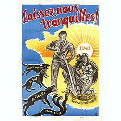
Laissez-nous tranquilles.
French propaganda poster printed by G. Mazeyrie and created by Jé. Dates back to the Vichy political regime. Very popular for the promotion of the National Revolution, t...
Date: Paris, 1941
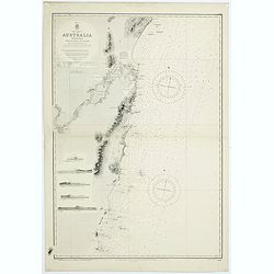
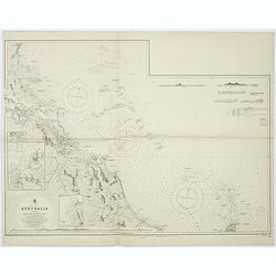
Sheet VI East coast of Australia. New South Wales Tacking Point to Coffs Islands surveyed by Comr. Fredk. W. Sidney R.N. . . 1862 - 1864. . .
Large chart representing East coast of Australia with New South Wales including Tacking Point to Coffs Islands surveyed by Comr. Fredk. W. Sidney R.N. from 1862 - 1864. F...
- $150 / ≈ €130
Date: London, 1939-1942
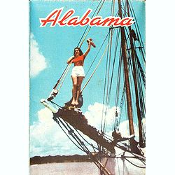
Alabama. Official Highway map 1942.
Folding road map of Alabama. Published in Montgomery, Alabama by Paragon Press. Mileage chart and six city plans in margin; verso includes text and photos. Scale [ca. 1:8...
- $100 / ≈ €87
Date: Alabama, Paragon Press, 1942
![Singapura em poder das Japoneses. [Singapore in Japanese Power]](/uploads/cache/48732-250x250.jpg)
Singapura em poder das Japoneses. [Singapore in Japanese Power]
An uncommon large Portuguese language and produced broadside celebrating the Japanese invasion of Singapore during WWII. It was published on behalf of the German Army Hig...
- $750 / ≈ €649
Date: Portugal, ca 1942
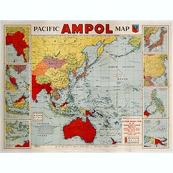
Pacific AMPOL Map
A large and very colorful World War II era map of the Pacific Ocean produced with the complements of the Australian Motorists Petrol Co. Ltd. The map itself shows the Pac...
- $1000 / ≈ €865
Date: Australia, ca 1942
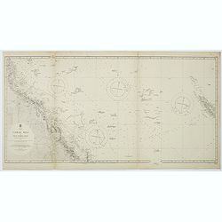
Australia, Coral Sea and Great Barrier Reefs shewing the inner and outer routes to Torres Strait. Sheet 1. . .
Large scale chart representing the Great Barrier Reef and the Coral Sea showing routes to the Torres Strait. Sheet 1.First published at the Admiralty 1860 with new editio...
- $150 / ≈ €130
Date: London, 1869-1943
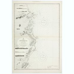
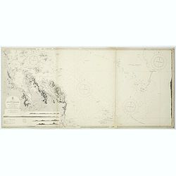
East coast of Australia. New South Wales. Sheet VII, Coffs Islands to Evans Head surveyed by Comr. Fredk. W. Sidney R.N. assisted by E.P. Bedwell & J.T. Gowlland, Masters & S. Guy, 2nd Master R.N. 1864-5
Large chart representing East coast of Australia with New South Wales including Coffs Islands to Evans Head surveyed by Comr. Fredk. W. Sidney R.N. First published at the...
- $150 / ≈ €130
Date: London, 1907-1943
Sheet V East coast of Australia. New South Wales Evans Head to Danger Pt. surveyed by Comr. Fredk. W. Sidney R.N. . . 1864-5. . .
Large chart representing East coast of Australia with New South Wales including Evans Head to Danger Pt. surveyed by Comr. Fredk. W. Sidney R.N. from 1864 - 1865. First p...
- $150 / ≈ €130
Date: London, 1866-1943
Australia - East coast Queensland Keppel Bay and Islands surveyed by staff Commr. J.Jeffery. . . 1864. . .
Large chart representing East coast of Australia with Queensland including Keppel Bay and Islands surveyed by Comr. J.Jeffery in 1864. First published at the Admiralty 3r...
- $150 / ≈ €130
Date: London, 1866-1943
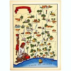
Cote d'Ivoire.
Very decorative, informative map of the Ivory coast. The map is filled with buildings, animals, a ship, figures and two locals in their typical dress.In lower left corner...
- $90 / ≈ €78
Date: France, 1943
Freedom of the Air.
A world map packed with information about aviation and the aluminum industry.The use of aircraft in warfare, especially in the roles of close ground support and strategic...
- $230 / ≈ €199
Date: United-States, 1943
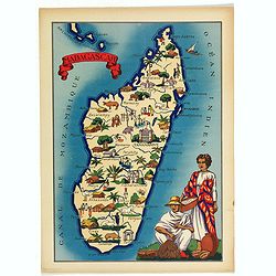
Madagascar.
Very decorative, informative map of Madagascar. The map is filled with buildings, animals, figures and two locals in their typical dress.In lower left corner "Imprim...
- $90 / ≈ €78
Date: France, 1943
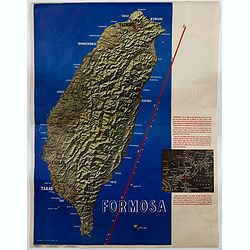
Formosa.
A large poster size map of the island of Formosa (Taiwan) off the Chinese mainland, prepared as a News Maps special edition during WWII. There is a red diagonal measureme...
- $750 / ≈ €649
Date: New York, 1943
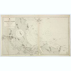
Sheet XI East coast of Australia - Sandy Cape to Keppel isles surveyed by Staff Commr. E.P. Bedwell, Navg. Lieutt. E.H.S. Bray, and Navg. Sub. Lieutt. E.R. Connor, 1870
Large chart representing East coast of Australia from Sandy Cape to Keppel isles surveyed by Staff Commr. E.P. Bedwell. With two inset charts of Pancake Creek. Scale 1:24...
- $150 / ≈ €130
Date: London, 1883-1944
Sheet XII East coast of Australia Queensland Keppel Isles to Percy Isles. . .
Large chart representing east coast of Australia's Queensland showing Keppel Isles to Percy Isles with relief shown by hachures, spot heights and bathymetric soundings. S...
- $150 / ≈ €130
Date: London, 1932-1944
![[Escape map] N°34 Southeast Asia + Northeast Asia.](/uploads/cache/40293-250x250.jpg)
[Escape map] N°34 Southeast Asia + Northeast Asia.
A fine "survival map" or "escape map" of China was compiled for the U.S. Army Air Forces. South China side has an inset of Taiwan (Formosa). These lig...
- $125 / ≈ €108
Date: Washington, D.C. 1944

China Southeast Coast.
A very large US Army and Naval map of the south east coast of China, published during the second world war. Map extent is from Kweichow Province in the west, to Kwangsi P...
- $1250 / ≈ €1082
Date: [New York], 1944
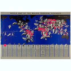
World Map of the Major Tropical Diseases.
A gruesome overview of some of the world’s deadliest tropical diseases designed by Boris Artzybasheff.This graphic world map uses hideous imagery and vivid color to hig...
- $270 / ≈ €234
Date: London, 1944
![Australia, E. coast - Queensland Percy isles to Whitsunday I. chiefly from a joint Admiralty & Colonial survey by Staff Commander Bedwell, R.N. 1873 to 1879 [1945]](/uploads/cache/36212-250x250.jpg)
Australia, E. coast - Queensland Percy isles to Whitsunday I. chiefly from a joint Admiralty & Colonial survey by Staff Commander Bedwell, R.N. 1873 to 1879 [1945]
Large chart representing East coast of Australia with Queensland from Percy isles to Whitsunday Island, with inset of Beverley Islands Anchorage. Scale 1:74,000. in lower...
- $150 / ≈ €130
Date: London, 1882-1945
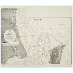
Australia, E. coast - Queensland Moreton Bay
Large chart representing East coast of Australia with Moreton Bay in Queensland.After a survey by Comr. J.Jeffery, etc. in 1865. New edition at the Admiralty 1870. With ...
Date: London, 1882-1945
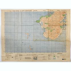
Hong Kong and New Territory - Tung Kwu.
A third edition air survey map of this portion of Lantau Island, to the west of Hong Kong, performed by the RAF. Originally published in 1931, then with minor corrections...
- $300 / ≈ €260
Date: London, 1945
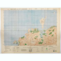
Hong Kong and New Territory - Tai O.
A third edition air survey map of this mainland portion of north west Hong Kong and New Territory, performed by the RAF. Originally published in 1931, then with minor cor...
- $400 / ≈ €346
Date: London, 1945
![Map of the Occupied Areas. Carte des Zones d'Occupation. Der Besatzungs-Zonen mit Neuen Postleitgebieten. Karta Okkupacionnych Zon [in Cyrillic.]](/uploads/cache/42060-250x250.jpg)
Map of the Occupied Areas. Carte des Zones d'Occupation. Der Besatzungs-Zonen mit Neuen Postleitgebieten. Karta Okkupacionnych Zon [in Cyrillic.]
A poster map of Germany and Austria showing the Allied occupation zones as agreed at the Potsdam Conference after the end of the Second World War, with an inset detail of...
Date: Frankfurt-am-Maine: Atlanta-Service, 1946
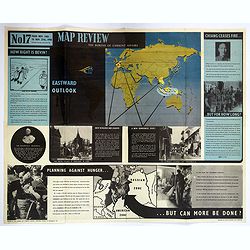
Map Review No.17. Eastwood Outlook.
A large double sided 'current affairs' poster. One side features a eastern hemisphere world map, and deals with matters arising in South East Asia, the Far East and Europ...
- $180 / ≈ €156
Date: London, 1946
MEMORANDUM Vlade Demokratske Federativne Jugoslavije po pitanju Juliske Krajine i drugih jugoslavenskih teritorija pod Italijom.
Memorandum of the government of the Democratic Federative Yugoslavia concerning the questions of the Jilian March and other Yugoslav territories under Italy.Julian March ...
- $300 / ≈ €260
Date: London, 1946
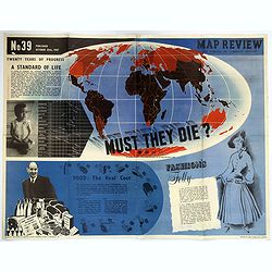
Map Review No.39. - Twenty Years of Progress, 'A Standard of Life'.
A large fully colored double-sided poster of the world colored to highlight the number of children who die each year before the age of one. This is accompanied by a short...
- $200 / ≈ €173
Date: London, 1947

Ile de France.
Touristic poster by Jean Moles depicting the Ile-de-France region, printed in France and published for the French government. Figurs Compiègne, Chantilly, Meaux, Fontain...
- $300 / ≈ €260
Date: France, 1947
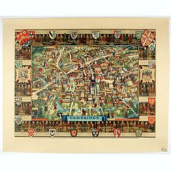
Cambridge.
Though the city had endured significant damage during the Second World War, which ended only a few years prior to publication, there is little indication of the destructi...
- $550 / ≈ €476
Date: London, 1948
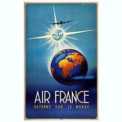
Air France Rayonne sur le monde.
Advertising poster from Air France, the french airline company. The poster has always occupied a special place in Air France's communication. With a heritage of more than...
Date: Imprimerie Goosens, Paris, ca. 1940-1950
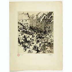
Mulhouse La Place
Etching of the town square of Mulhausen in Alsace, France. Collectors stamp in lower left margin, numbered 209/250 copies, signed in pencil in the margin "Rolle"...
- $100 / ≈ €87
Date: France, ca. 1950
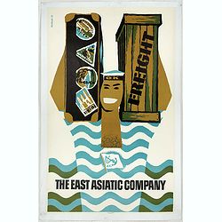
The East Asiatic Company.
Very decorative and uncommon 'The East Asiatic Company' poster by Kolind. Depicting a sailor loading or unloading a ship.The East Asiatic Company (EAC) came into being in...
- $650 / ≈ €563
Date: Egmont H. Petersen, København, 1950
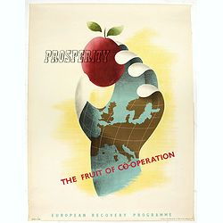
Prosperity - The Fruit of Cooperation.
NATO poster for European Cooperation by Brian E. Dear. On the poster the slogan "Prosperity the fruit of cooperation".The poster is showing a hand holding an ap...
- $500 / ≈ €433
Date: Kühn & Zoon Rotterdam, 1950
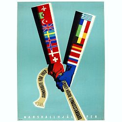
Samarbete för Frederihet-Högre Levnadsstandard. Marshall Hjälpen.
NATO poster for European Cooperation by Erik Oelmebo, depicting a red and a blue arm representing the American flag with the sleeves covered with the flags of the Europea...
- $250 / ≈ €216
Date: Kühn & Zoon Rotterdam, 1950
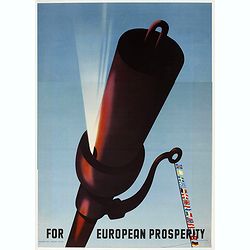
For European Prosperity.
Marshall Plan poster, 5th price winner by Wladimir Flem, a Russian poster artist born in St. Petersburg in 1910. This is one of the 25 finalists in the 1950 “Intra-Euro...
- $250 / ≈ €216
Date: Kühn en Zoon Rotterdam, 1950
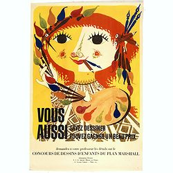
Vous aussi savez dessiner - Vous aussi pouvez gagner un beau prix . . .
Marshall Plan poster for a kid drawing contest. This is one of the 25 finalists in the 1950 “Intra-European Poster Competition” promoting the Marshall Plan to reconst...
- $150 / ≈ €130
Date: Kühn en Zoon Rotterdam, 1950
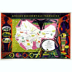
Afrique Occidentale Française AOF.
Beautiful and decorative lithograph pictorial map of Equatorial Africa, showing animals in a beautiful design… Made for Agence de la France d'Outre-Mer. The artist Alai...
- $1100 / ≈ €952
Date: Imprimerie Raidot, Paris, ca. 1950

Beer poster.
Official Oktoberfest posters started being produced each year beginning in 1952. This poster was created by German artist Theodor Abeking. Other artists who made posters ...
- $300 / ≈ €260
Date: Paris, ca. 1950
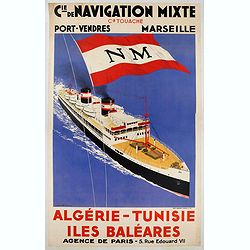
CIE. DE NAVIGATION MIXTE / ALGERIE - TUNISIE.
Advertising poster for Touache Cie, made by Sandy Hook and printed by Chaix, Paris. Sandy-Hook was a French painter, poster designer and illustrator specialized in repres...
- $900 / ≈ €779
Date: Paris, ca. 1950
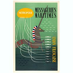
Metropole, Messageries Maritimes Union Française.
Original lithographed poster created by the artist Poulain for "Les Messageries Maritimes", showing several boats and a unicorn. Les Messageries Maritimes Compa...
Date: Paris, ca. 1950
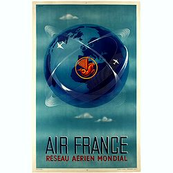
Réseau aérien mondial.
"Sur les ailes d'Air France, découvrez le monde à votre tour" advertising planisphere poster from AIR France, the French airline company. The poster has alway...
Date: Imprimerie Perceval Paris, ca. 1940-1950
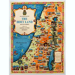
Ilustrated Map of The Holy Land for use in schools…
A visually striking and impressive pictorial map of The Holy Land, as issued by the National Savings Movement / Committee during the 1950s. In the upper left quadrant of...
- $250 / ≈ €216
Date: London, ca. 1950
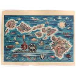
The Dole Map of the Hawaiian Islands.
A terrific, colorful poster of the Hawaiian Islands by Joseph Feher, commissioned for the Hawaiian Pineaple Co. The poster displays all eight of the major islands in the ...
- $250 / ≈ €216
Date: USA, 1950
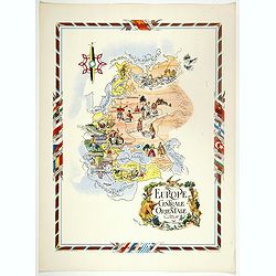
L'Europe Centrale et Orientale.
Pictorial tourism poster of central and eastern Europe, showing different life scenes relative to the culture's country.Learn more about pictorial maps. [+]
- $100 / ≈ €87
Date: Paris, 1951
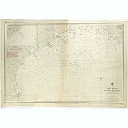
Gulf of Mexico. Ship Shoal to Brazos Santiago.
A large sea chart of the Gulf of Mexico, Ship Shoal to Brazos Santiago, 'from Admiralty Charts and US Government charts, corrected to 1943'. (In fact there are correction...
- $200 / ≈ €173
Date: London, 1943 updated to 1951