Browse Listings
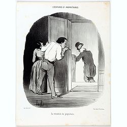
Locataires et Propriétaires. La reconduite du propriétaire. (Pl 27)
A couple is saying goodbye to their landlord as he leaves their apartment. From "Locataires et Propriétaires" [Tenants and Landlords], number 27, published in ...
- $175 / ≈ €151
Date: Paris, Le Charivari, December 2, 1847
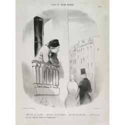
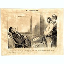
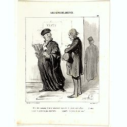
Tout ce qu'on voudra. Moi aussi j'ai été jeune …(Plate 3)
Translation in English of title text: I have also been young . . . I have also been an amiable person . . .I have also been loved . . . And all this did not stop me from ...
Date: Paris, 1847
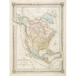
Carte L'Amérique Septentrionale..
Detailed map of North America, prepared by J.G.Barbié du Bocage.Engraved by Ch.Smith, published by Basset who was established in Paris, rue de Seine 33.
- $100 / ≈ €87
Date: Paris, 1848
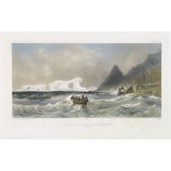
Débarquement sur les iles Powell, le 20 février 1838.
Exquisite contemporary colored lithograph of the Powell islands, situated near the South Orkney Islands, with Dumont D'Urville's officers leaving the island. Drawn by Lou...
- $400 / ≈ €346
Date: Paris, 1848
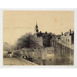
The Hague
Attractive lithography showing a street scene in The Hague. Lithographed by Jan Weissenbruch, published by K.Fuhri, included in Kunst Kroniek.
- $40 / ≈ €35
Date: The Hague, 1848
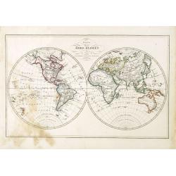
Karta öfver Jord-Globen (World map)
An very rare double hemisphere world map. This is an heavenly updated version of his map of 1817 and is now dated 1848, Australia with new nomenclature and the old title ...
Date: A. Wiborgs förlag, Stockholm, ca. 1848
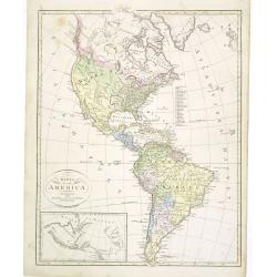
Karta öfver America.
An very rare map of the continent of America with Swedish text. This is an heavenly updated version of his map of 1818 and is now dated 1832.From his atlas "Geograph...
- $300 / ≈ €260
Date: A. Wiborgs förlag, Stockholm, ca. 1848
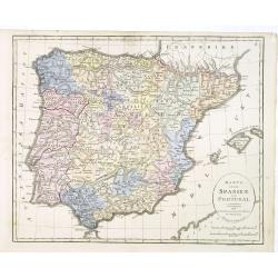
Karta öfver Spanien och Portugal.
An very rare map of Spain and Portugal with Swedish text. This is an updated version of his map of 1819 and is now dated 1833.From his atlas "Geographisk Hand-Atlas&...
- $100 / ≈ €87
Date: A. Wiborgs förlag, Stockholm, ca. 1848
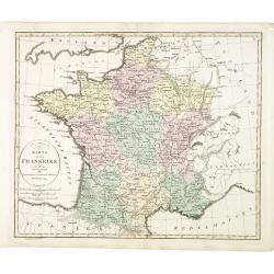
Karta öfver Frankrike.
An very rare map of France with Swedish text. This is an updated version of his map of 1819 and is now dated 1831.From his atlas "Geographisk Hand-Atlas" first ...
- $100 / ≈ €87
Date: A. Wiborgs förlag, Stockholm, ca. 1848
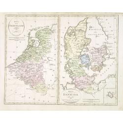
Karta öfver Nederland. / Karta öfver Danmark.
An very rare map of The Low Countries and Denmark with Swedish text. This is an updated version of his map of 1820 and is now dated 1832.From his atlas "Geographisk ...
- $110 / ≈ €95
Date: A. Wiborgs förlag, Stockholm, ca. 1848
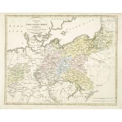
Karta öfver Preussiska riket.
An very rare map of Eastern part of Germany, with Pomerania and part of present-day Poland with Swedish text. This is an updated version of his map of 1820 and is now dat...
- $150 / ≈ €130
Date: A. Wiborgs förlag, Stockholm, ca. 1848
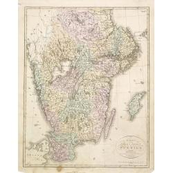
Karta öfver södra delen af Sverige.
An very rare map of Sweden with Swedish text. This is an updated version of his map of 1822 and is now dated 1839. In upper right corner Suppl. 1.From his atlas "Geo...
- $150 / ≈ €130
Date: A. Wiborgs förlag, Stockholm, ca. 1848
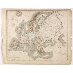
Karta öfver Europa.
An very rare map of Europe with a Swedish text. The map is dated 1839.Published as a supplement map in his atlas "Geographisk Hand-Atlas" first published in 181...
- $75 / ≈ €65
Date: A. Wiborgs förlag, Stockholm, ca. 1848
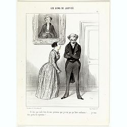
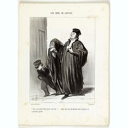
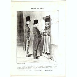
Les Gens de Justice. - Et dire que voilà trois de mes prévenus que je n'ai pas pu faire condamner! . . .
Second state (of 2), with text. From "Les Gens de Justice". Text below image : - Et dire que voilà trois de mes prévenus que je n'ai pas pu faire condamner! ....
Date: Paris, 1845-1848
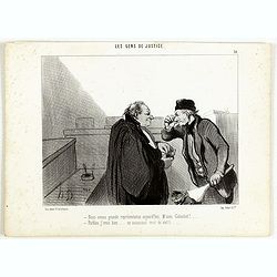
Les Gens de Justice. - Nous avons grande représentation aujourd'hui . . .
Second state (of 2), with text. From "Les Gens de Justice". Text below image : - Nous avons grande représentation aujourd'hui, M'sieu Galuchet! . . . - Parble...
Date: Paris, 1845-1848
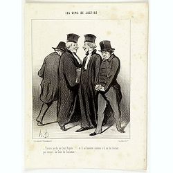
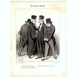
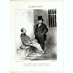
Les Gens de Justice. - Encore perdu en cour royale . . .
Second state (of 2), with text. From "Les Gens de Justice". Text below image : - Encore perdu en cour royale . . . et il se lamente comme s'il ne lui restait pa...
Date: Paris, 1845-1848
Les Gens de Justice. - Vous avez perdu votre procès c'est vrai . . .
Second state (of 2), with text. From "Les Gens de Justice". Text below image : - Vous avez perdu votre procès c'est vrai . . . mais vous avez du éprouver bien...
Date: Paris, 1845-1848
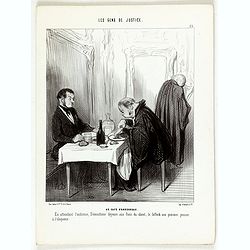
Les Gens de Justice. - Au café d'Aguesseau.
Second state (of 2), with text. From "Les Gens de Justice". Text below image : - Au café d'Aguesseau. En attendant l'audience, Démosthéne déjeune aux frais ...
Date: Paris, 1845-1848

FEMME DE NAZARETH (Palestine). Costumes Syriens 10.
A beautiful hand colored lithograph of a woman from Nazareth (Palestine) published in the French work "Galerie Royale de Costumes peints d´après nature par divers ...
- $300 / ≈ €260
Date: Paris, Chez Aubert & Cie., 1842-1848
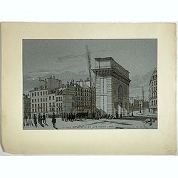
La Porte de S. Martin 24 Juin 3 heures du matin.
A view of St. Martin a well known place in Paris, by the French draughtsman André Durand.
- $100 / ≈ €87
Date: Paris, 1848
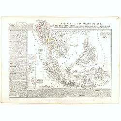
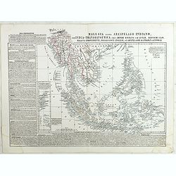
Malesia ossia Arcipelago Indiano, ed India-Transgangetica.
Attractive map of the Southeast Asia by a cartographer from Naples, listing his cartographic sources and giving political and statistical information on the areas covered...
- $500 / ≈ €433
Date: Naples, 1848
![The Cerographic Missionary Atlas. [Imprint inside front cover:] Entered according to Act of Congress, in the year 1848, By Se. E. Morse & Co.,....](/uploads/cache/41699-250x250.jpg)
The Cerographic Missionary Atlas. [Imprint inside front cover:] Entered according to Act of Congress, in the year 1848, By Se. E. Morse & Co.,....
An unusually and quite early American atlas of areas where missionary activity was being, or could be conducted. Including two global hemispheres showing North and South ...
- $1250 / ≈ €1082
Date: New York, 1848
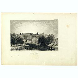
Czaritzana bei Moskau. (Tsaritsyno In Moscow)
Steel engraving with a panoramic view of the Tsaritsyn Palace In Moscow, published in "Meyers Universum oder Abbildung und Beschreibung des Sehenswerthesten und Merk...
- $20 / ≈ €17
Date: Hildburghausen, 1848
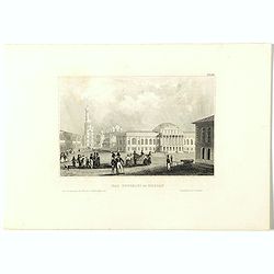
Das Zeughaus in Moscau.
Steel engraving of the Kremlin, published in "Meyers Universum oder Abbildung und Beschreibung des Sehenswerthesten und Merkwürdigsten der Natur und Kunst auf der g...
- $25 / ≈ €22
Date: Hildburghausen, 1848
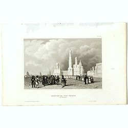
Kloster des Ivan Velekoi in Moscau.
Steel engraving of the Kremlin, published in "Meyers Universum oder Abbildung und Beschreibung des Sehenswerthesten und Merkwürdigsten der Natur und Kunst auf der g...
- $25 / ≈ €22
Date: Hildburghausen, 1848
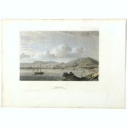
Kertsch im südlichen Russland. (Kerch)
Steel engraving with a panoramic view of the town of Krech, published in "Meyers Universum oder Abbildung und Beschreibung des Sehenswerthesten und Merkwürdigsten d...
- $15 / ≈ €13
Date: Hildburghausen, 1848

Zarskoe. (Tsarskoye Selo)
Steel engraving with a panoramic view of the town of Zarskoe, published in "Meyers Universum oder Abbildung und Beschreibung des Sehenswerthesten und Merkwürdigsten...
- $20 / ≈ €17
Date: Hildburghausen, 1848
Malesia ossia Arcipelago Indiano, ed India-Transgangetica . . .
Attractive map of the Southeast Asia by a cartographer from Naples, listing his cartographic sources and giving political and statistical information on the areas covered...
Date: Naples, 1848
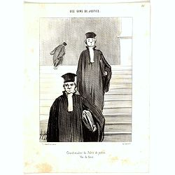
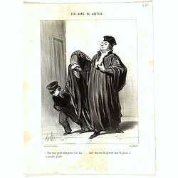
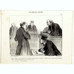
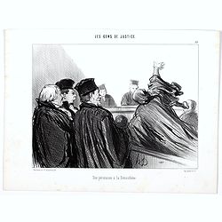
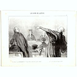
Grand escalier du Palais de justice, Vue de faces.
Third state (of 3), with text, number (36) erased. From "Les Gens de Justice", published " Chez Auber & Cie, Pl. de la Bourse,29". Text below imag...
Date: Paris, 1848
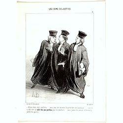
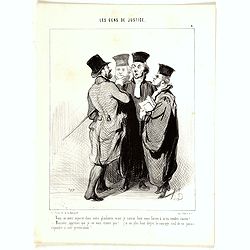
- Allons donc, chers confrères .... vous avez tort de vous disputer hors de l'audience..... ce lieu ci doit être la salle des pas perdus pour les plaideurs..... mais jamais les avocats ne doivent y perdre des paroles......
Second state (of 2), with text, numbered 7. From "Les Gens de Justice", published " Chez Auber & Cie, Pl. de la Bourse,29". Text below image : Com...
Date: Paris, 1848
Et dire que voilà trois de mes prévenus que je n'ai pas pu faire condamner! .... je vais être perdu de réputation!..
Second state (of 2), with text, numbered 12. From "Les Gens de Justice", published " Chez Auber & Cie, Pl. de la Bourse,29". Text below image : - ...
Date: Paris, 1848
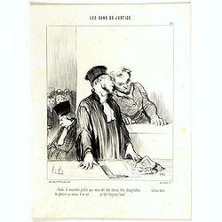
Mr. l'avocat a rendu pleine justice au rare talent déployé par le ministère public dans son réquisitoire; ...
Second state (of 2), with text, numbered 16. From "Les Gens de Justice", published " Chez Auber & Cie, Pl. de la Bourse,29". Text below image : Th...
Date: Paris, 1848
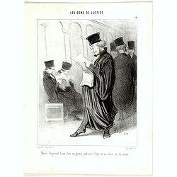
Maitre Chapotard lisant dans un journal judiciaire l'éloge de lui même par lui même.
Second state (of 2), with text, numbered 18. From "Les Gens de Justice", published "Chez Auber & Cie, Pl. de la Bourse,29". Text below image : Law...
Date: Paris, 1848
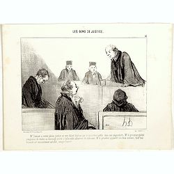
Voilà le ministère public qui vous dit des choses très désagréables........ tâchez donc de pleurer au moins d'un oeil ... ça fait toujours bien!......
Second state (of 3), with text, numbered 21. From "Les Gens de Justice", published " Chez Auber & Cie, Pl. de la Bourse,29". Text below image : He...
Date: Paris, 1848

Il défend l'orphelin et la veuve, à moins pourtant qu'il n'attaque la veuve et l'orphelin.
Second state (of 2), with text, numbered 22. From "Les Gens de Justice", published " Chez Auber & Cie, Pl. de la Bourse,29". Text below image : He...
Date: Paris, 1848
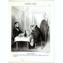
AU CAFÉ D'AGUESSEAU. En attendant l'audience, Démosthène déjeune aux frais du client, le bifteck aux pommes pousse à l'éloquence...
Third state (of 3), with text, numbered 23. From "Les Gens de Justice", published " Chez Auber & Cie, Pl. de la Bourse,29". Text below image : AT ...
Date: Paris, 1848
Encore perdu en Cour Royale .... et il se lamente comme s'il ne lui restait pas encore la Cour de Cassation!...
Second state (of 2), with text, number (34) erased. From "Les Gens de Justice", published " Chez Auber & Cie, Pl. de la Bourse,29".Text below imag...
- $750 / ≈ €649
Date: Paris,1848
Vous avez perdu votre procès c'est vrai ..... mais vous avez du éprouver bien du plaisir à m'entendre plaider.
Second state (of 2), with text, number (35) erased. From "Les Gens de Justice", published " Chez Auber & Cie, Pl. de la Bourse, 29". Text below im...
- $750 / ≈ €649
Date: Paris,1848
La cour, vidant le déliberé,...
Second state (of 2), with text, numbered 4. From "Les Gens de Justice", published " Chez Auber & Cie, Pl. de la Bourse,29". Text below image : - &...
- $750 / ≈ €649
Date: Paris, 1848
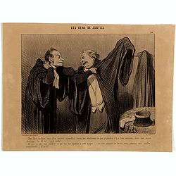
Comme je vous ai bien dit vertement votre fait!... Mais aussi, que je vous ai cruement riposté les choses les plus désagréables!... - Nous avons été beaux!... - Nous avons été magnifiques!...
Second state (of 2), with text, numbered 8. From "Les Gens de Justice", published " Chez Auber & Cie, Pl. de la Bourse,29". Translated text below ...
- $750 / ≈ €649
Date: Paris, 1848
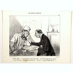
Vous aviez faim ... vous aviez faim...ça n'est pas une raison ... mais moi aussi presque tous les jours j'ai faim et je ne vole pas pour cela!....vol j'espère être plus heureux!......
Second state (of 3), with text, numbered 15. From "Les Gens de Justice", published " Chez Auber & Cie, Pl. de la Bourse,29". Translated text below...
- $300 / ≈ €260
Date: Paris, 1848
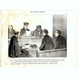
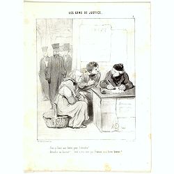
Voyons témoin il serait important de nous faire le détail exact et complet de l'emploi de votre journée du 12 Avril dernier?..
Second state (of 2), with text, numbered 17. From "Les Gens de Justice", published " Chez Auber & Cie, Pl. de la Bourse,29". Translated text below...
- $750 / ≈ €649
Date: Paris, 1848
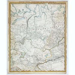
Western siberia, independent tartary, khiva, bokhara.....
This map was originally published by The Society for the Diffusion of Useful Knowledge in 1838, this date is printed on the map. This edition of the map was printed and p...
- $75 / ≈ €65
Date: London, 1848
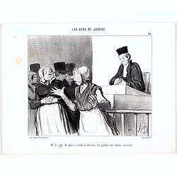
Les Gens de Justice. - Mr. le juge de paix a rendu sa décision, les parties sont censées conciliées. (pl 25).
Second state, with letters. From "Les Gens de Justice". Text below image : - Mr. le juge de paix a rendu sa décision, les parties sont censées conciliées. (T...
Date: Paris, 1845-1848
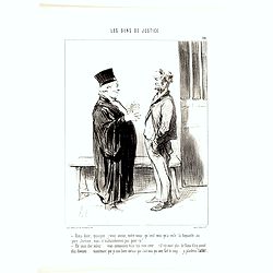
Les Gens de Justice. - Un plaideur peu satisfait. (pl 26).
Second state, with letters. From "Les Gens de Justice". Text below image : -Un plaideur peu satisfait. (A rather unsatisfied litigant). Around the mid-1840s Dau...
Date: Paris, 1845-1848
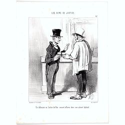
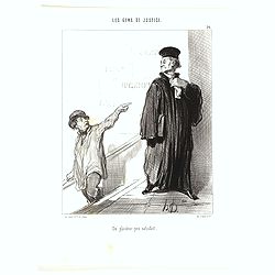
Les Gens de Justice. - Un défenseur en Justice de Paix causant des affaires dans son cabinet habituel. (pl 27).
Second state, with letters. From "Les Gens de Justice". Text below image : -Un défenseur en Justice de Paix causant des affaires dans son cabinet habituel. (A ...
Date: Paris, 1845-1848
Les Gens de Justice. - Ainsi donc, quoique j'vous avoue, entre nous, qu'cest moi qu'a volé la toquante au pere Jérôme . . . (pl 28)
Second state, with letters. From "Les Gens de Justice". Text below image : - Ainsi donc, quoique j'vous avoue, entre nous, qu'cest moi qu'a volé la toquante au...
Date: Paris, 1845-1848
Les Gens de Justice. - Plaidez, plaidez . . . ça sera un bon tour à jouer à votre voisin. . . (pl 29)
Second state (of 2), with letters. From "Les Gens de Justice". Text below image : - Plaidez, plaidez . . . ça sera un bon tour à jouer à votre voisin . . . v...
Date: Paris, 1845-1848

Les Gens de Justice. - L'avocat qui se trouve mal - dernière ressource quand la cause est bien malade. (pl 30)
Third state (of 3), with letters, "l'avocat" (with small a). From "Les Gens de Justice". Text below image : - L'avocat qui se trouve mal - dernière r...
Date: Paris, 1845-1848
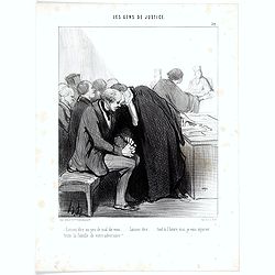
Les Gens de Justice. - Laissez dire un peu de mal de vous ... Laissez dire . . . (pl 32)
Second state, with letters. From "Les Gens de Justice". Text below image : - Laissez dire un peu de mal de vous … Laissez dire . . . (Don't you worry... just ...
Date: Paris, 1845-1848
Les Gens de Justice. - Une Péroraison à la Démosthène (pl 33)
Second state (of 2), with text. From "Les Gens de Justice". Text below image : - Une Péroraison à la Démosthène . Around the mid-1840s Daumier started publi...
Date: Paris, 1845-1848
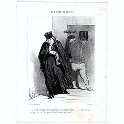
Les Gens de Justice. - Il parait décidement que mon gaillard est un grand scélérat . . . (pl 37)
Second state (of 2), with letters. From "Les Gens de Justice". Text below image : - Il parait décidement que mon gaillard est un grand scélérat. (It really s...
Date: Paris, 1845-1848
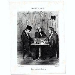
Les Gens de Justice. - Quand le crime ne donne pas . (pl 38)
Second state (of 3), with letters. From "Les Gens de Justice". Text below image : - Quand le crime ne donne pas. (When crime doesn't pay). Around the mid-1840s ...
Date: Paris, 1845-1848
Mon cher Monsieur, il m'est absolument impossible de plaider votre affaire..... il vous manque les pièces les plus importantes...... (à part) les pièces de cent sous!....
Second state (of 2), with text, numbered 20. From "Les Gens de Justice", published " Chez Auber & Cie, Pl. de la Bourse,29". Text below image :...
- $400 / ≈ €346
Date: Paris, 1848
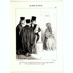
Quel dommage que cette charmante petite femme ne m'ait pas chargé de défendre sa cause...... comme je plaiderais que son mari est un gredin!....
Second state (of 2), with text, numbered 24. From "Les Gens de Justice", published " Chez Auber & Cie, Pl. de la Bourse,29". Text below image :...
- $400 / ≈ €346
Date: Paris, 1848
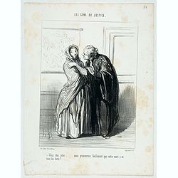
Les Gens de Justice. - Vous êtes jolie … Nous prouverons facilement que votre mari a eu tous les torts! ... (pl 39)
Second state (of 2), with text. From "Les Gens de Justice". Text below image : - Vous êtes jolie … Nous prouverons facilement que votre mari a eu tous les ...
- $150 / ≈ €130
Date: Paris, 1845-1848
Vous m'avez injurié dans votre plaidoirie, mais je saurai bien vous forcer à m'en rendre raison!... - Monsieur, apprenez que je ne vous crains pas!.. J'ai au plus haut degré, le courage civil ...
Second state (of 2), with text, numbered 9. From "Les Gens de Justice", published " Chez Auber & Cie, Pl. de la Bourse,29". Text below image ...
- $300 / ≈ €260
Date: Paris, 1848
Et parlant à sa portière ainsi déclarée, lui ai signifié qu'il eut à obtempérer à la dite sommation, sinon et faute de ce faire,…
Third state (of 3), with text, numbered 10. From "Les Gens de Justice", published " Chez Auber & Cie, Pl. de la Bourse, 29". Text below image :...
- $200 / ≈ €173
Date: Paris, 1848
Ce qui m'chiffonne c'est que j'suis accusé de douze vols!.. - Il y en a douze... tant mieux... je plaiderai la monomanie!…
Second state (of 2), with text, numbered 19. From "Les Gens de Justice", published " Chez Auber & Cie, Pl. de la Bourse, 29". Text below image ...
- $400 / ≈ €346
Date: Paris, 1848
Faut-y faire une lettre pour l'attendrir?....
Third state (of 3), with text, numbered 3. From "Les Gens de Justice", published " Chez Auber & Cie, Pl. de la Bourse,29". Text below image : -...
- $200 / ≈ €173
Date: Paris, 1848
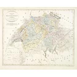
Karta öfver Helvetien.
An very rare map of Switzerland with Swedish text. This is an updated version of his map of 1820 and is now dated 1833.From his atlas "Geographisk Hand-Atlas" f...
Date: A. Wiborgs förlag, Stockholm, ca. 1848
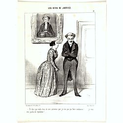
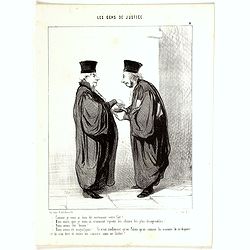
Un avocat qui évidemment est rempli de la conviction la plus intime.......... que son client le paiera bien.
Second state (of 2), with text, numbered 6. From "Les Gens de Justice", published " Chez Auber & Cie, Pl. de la Bourse,29". Text below image : A...
Date: Paris, 1848
Dites donc, confrère, vous allez soutenir aujourd'hui contre moi absolument ce que je plaidais il y a trois semaines, dans une cause identique... hé hé hé!.. c'est drôle!..
Second state (of 2), with text, numbered 14. From "Les Gens de Justice", published " Chez Auber & Cie, Pl. de la Bourse,29". Translated text below...
Date: Paris, 1848
Shipping
Attractive lithography showing Dutch vessels off the Dutch coast, by F.A.Breuhaus de Groot. Published in Kunst Kroniek.
Date: The Hague, 1849
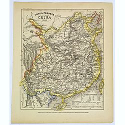
China-Propria oder das eigentliche China.
Map number 48 from Meyer's 'Zeitung's Atlas', a popular German 'pocket atlas', published during the mid nineteenth century. This map of China shows the mainland, and the ...
Date: Hildburghausen / Philadelphia, 1849
![Bataille de Pultusk, le 26 Decembre 1806. [manuscript map]](/uploads/cache/38810-250x250.jpg)
Bataille de Pultusk, le 26 Decembre 1806. [manuscript map]
Manuscript map of the siege of Pultusk (located on the west bank of the River Narew approximately 50 kilometres (31 mi) north of Warsaw), on 26 December 1806. With a colo...
- $1750 / ≈ €1515
Date: Breda, 1849
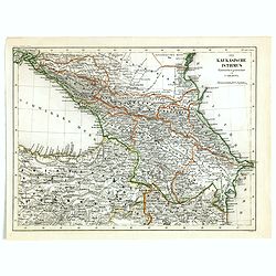
Der Kaukasische Istmus . . .
Detailed contemporary colored map of the countries of the Caucasus Mountains. Steel engraving appeared in "Meyer's Lexicon. Atlas der Geographie". Engraved by C...
Date: Hildburghausen, 1849
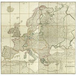
Carta geografica statistica e stradale d'Europa diseguata ed insica da Stanislao Stucchi. . . in Milano 1849.
Large engraved folding map of Europe (1545x1570 mm), consisting of 54 plates linen backed, the boundaries in early hand-color.Stanislao Stucchi was an engraver and printe...
- $600 / ≈ €519
Date: Milan, Turin, 1849
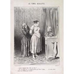
Les femmes socialistes. Comme vous vous faites belles. . . (Plate 2)
Translation in English of title text: You are really getting dressed up, my dear! - I am going to a banquet presided by Pierre Leroux. And you know how he enjoys beautifu...
Date: Paris, 23 April 1849
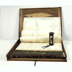
J.Horsburgh/ R.H.Bate / G.H.Stapleton. The two chart books are bound in contemp. half calf, and include together 57 of the most up-to-date French (Depot général de la marine) and English (Hydrographic Office) charts available in 1847 for sailing t
BOOK 1 : Mainly charts by "Dépôt Général de la Marine" including 20 folding charts. The binding measuring 665x275mm, the charts mostly 595x910mm.1. Dépôt ...
- $50000 / ≈ €43272
Date: Paris, London, Hong Kong, 1835 - 1849
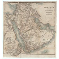
A Map of Arabia and Syria Laid Down Chiefly From Original Surveys Under the Superintendence of Lieut. Colonel Chesney, R.A.F.R.S. and drawn by W. H. Plate. L.L. D
This is one of the most significant and detailed maps of Arabia and the Persian Gulf. It is drawn by Plate using various sources. As stated below the cartouche the source...
Date: London, 1849
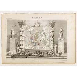
Europe.
While the map itself is quite simple without a great deal of detail, the surrounding engravings make this one of the most decorative 19th century maps. The map is frame...
- $150 / ≈ €130
Date: Paris 1850
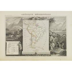
Amérique Méridionale.
A very decorative 19th century map of the continent colored to show political divisions. The map is surrounded by steel engraved scenes including horses, Indians, mining ...
Date: Paris, c. 1850
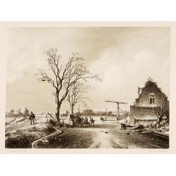
Dutch ice-scene.
Attractive lithography showing a typical Dutch ice-scene, lithographed by C.W. Mieling after a painting by J.B. Jongkind. Published in Kunst Kroniek.
- $75 / ≈ €65
Date: The Hague, 1850
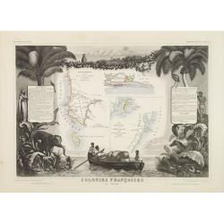
Colonies Françaises (en Afrique.)
A very decorative 19th century map of western coast of Africa and includes a map of the coast of Madagascar. The map is surrounded by portraits, animals, vegetation, etc....
- $100 / ≈ €87
Date: Paris, 1850

La Perruche Souris / La Perruche à moustaches / La Perruche à collier rose.
Two illustrations on one page Blue-winged Grass Parakeets.
Date: Paris, ca. 1850
![Oceanie. [Manuscript on paper]](/uploads/cache/01830-250x250.jpg)
Oceanie. [Manuscript on paper]
Decorative manuscript map on paper covering South East Asia, Australia and New Zealand.
Date: France ?, ca. 1850

OISEAUX. 1. Le Perroquet vert - 2. Le Mascarin.
Noteworthy bird print engraved by Massard after a drawing by Vauthier.
- $80 / ≈ €69
Date: Paris ca.1850

OISEAUX. 1. Le Kakatoes à huppe jaune - 2. Le Kakatoes à huppe rouge.
Noteworthy bird print engraved by Aubert after a drawing by Vauthier.
- $150 / ≈ €130
Date: Paris, ca.1850
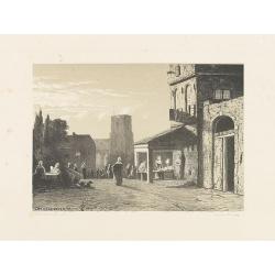
Dordrecht.
Attractive lithography showing a Dutch street scene, printed by C.W.Mieling and lithographed by Jan Weissenbruch. Published in Kunst Kroniek .
- $50 / ≈ €43
Date: The Hague 1850