Browse Listings

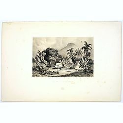
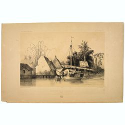
Mosquee du Village de Warou.
A lithograph of the mosque in the village of Waro, on the Indonesian island of Seram. Plate 128 taken from the 'Voyage au Pole et dans L'Oceanie…' Departing in late 183...
- $100 / ≈ €87
Date: Paris, 1842
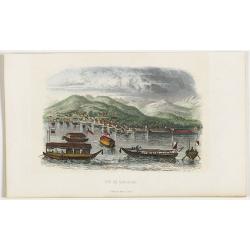
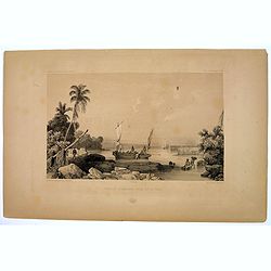
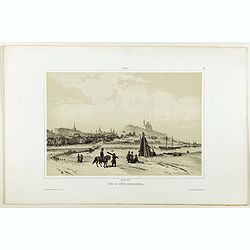
Vue de Nangasaki
View over the town from the water, identifying clearly Deshima with Japanese sloops in the fore ground. Engraved by Alp.Boilly.
- $120 / ≈ €104
Date: Paris, 1842
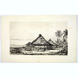
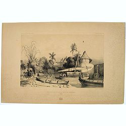
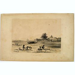
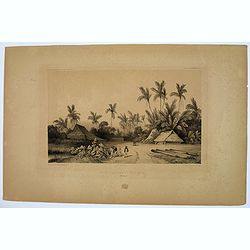
Rade et Village de Warrou.
An impressive lithograph of the dwellings to be found in the village of Waru, on the Indonesian island of Seram. Plate 126 taken from the 'Voyage au Pole et dans L'Oceani...
- $100 / ≈ €87
Date: Paris, 1842
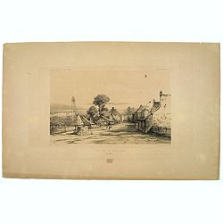
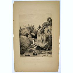
Site sur la Cote de Sumatra.
A lovely lithograph of a small settlement somewhere along the coast of Sumatra. Plate 154 taken from the 'Voyage au Pole et dans L'Oceanie…' Departing in late 1837 in t...
- $100 / ≈ €87
Date: Paris, 1842
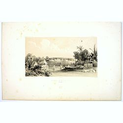
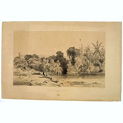
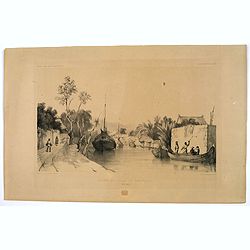
Riviere de Batou-Mera.
A lithograph of a simple bridge crossing the Batou-Mera river on the island of Ambone in the Moluccas, part of the Indonesian archipelago. Plate 110 taken from the 'Voyag...
- $100 / ≈ €87
Date: Paris, 1842
Une rue de Macassar.
A pretty lithograph of a street scene in the village of Makassar, on the southern edge of the Indonesian island of Sulawesi, formerly the Celebes Island. Plate 130 taken ...
- $30 / ≈ €26
Date: Paris, 1842
Une rue du Quartier Malais a Macassar.
An attractive lithograph of the Malay living quarters in the southern village of Makassar in Sulawesi, formerly the Celebes island in Indonesia. Plate 131 taken from the ...
- $30 / ≈ €26
Date: Paris, 1842
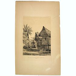
Case de Pecheurs dans la riviere Sambas.
A fishing hut seen along the Sambas River in Borneo. Plate 137 taken from the 'Voyage au Pole et dans L'Oceanie…' Departing in late 1837 in the Astrolabe and Zélée, D...
- $30 / ≈ €26
Date: Paris, 1842
Canal de Samarang.
A tranquil lithograph showing a wealthy man being gently rowed up the canal in Semerang, on the Indonesian island of Java Plate 148 taken from the 'Voyage au Pole et dans...
- $50 / ≈ €43
Date: Paris, 1842
Site sur les bords du canal de Samarang.
A lithograph showing a Canalside scene of activity in the northeastern Javanese city of Semarang. Plate 149 taken from the 'Voyage au Pole et dans L'Oceanie…' Departing...
- $50 / ≈ €43
Date: Paris, 1842
Quartier Malais a Samarang.
A fine lithograph depicting the Malay quarter in the north eastern Javanese city of Semarang in Indonesia. Plate 150 taken from the 'Voyage au Pole et dans L'Oceanie…' ...
- $75 / ≈ €65
Date: Paris, 1842
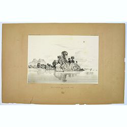
Entrée de la Riviere de Paiou.
A lithograph showing the entrance to the river Paiou on Vanikoro Island, a part of the Santa Cruz Group and the Solomon Islands in the Pacific. Plate 97 taken from the 'V...
- $50 / ≈ €43
Date: Paris, 1842
Aiguade d'Amboine.
Men with barrels in a river on the Indonesian island of Ambone. Plate112 taken from the 'Voyage au Pole et dans L'Oceanie…' Departing in late 1837 in the Astrolabe and ...
- $40 / ≈ €35
Date: Paris, 1842
Rade de Ternate.
A peaceful harbour scene on the Moluccan island of Ternate in Eastern Indonesia. Plate 106 taken from the 'Voyage au Pole et dans L'Oceanie…' Departing in late 1837 in ...
- $50 / ≈ €43
Date: Paris, 1842
Entrée du Canal de Samarang.
A lovely lithograph of the canal entrance to the north eastern city of Semarang, on the Indonesian island of Java. Plate 147 taken from the 'Voyage au Pole et dans L'Ocea...
- $50 / ≈ €43
Date: Paris, 1842
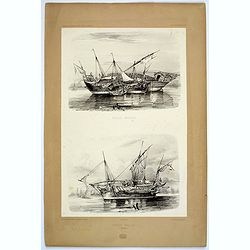
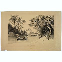
Praos Malais.
A pair of attractive Malay fishing boats. Plate 133 taken from the 'Voyage au Pole et dans L'Oceanie…' Departing in late 1837 in the Astrolabe and Zélée, Dumont D'Urv...
- $50 / ≈ €43
Date: Paris, 1842
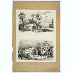
Tombeaux Malais pres de Coupang.
A lithograph displaying a pair of funeral monuments of both the Chinese and Malays, on the Indonesian island of Timor. Plate 192 taken from the 'Voyage au Pole et dans L'...
- $30 / ≈ €26
Date: Paris, 1842
Ancien Etablissement Hollandais.
An ancient Dutch settlement in S.E. Asia. Plate123 taken from the 'Voyage au Pole et dans L'Oceanie…' Departing in late 1837 in the Astrolabe and Zélée, Dumont D'Urvi...
- $50 / ≈ €43
Date: Paris, 1842
Aiguade d'Amboine pres de la Mer.
A lithograph of sailors unloading stores from a small sail boat in a tropical bay on the island of Amboina in Indonesia. Plate 112 taken from the 'Voyage au Pole et dans ...
- $50 / ≈ €43
Date: Paris, 1842

Les Baigneurs. Une Facétie. Cocher! Cocher! Avez-vous deux places en lapins? (Plate 24)
Translation in English of title text: A PRACTICAL JOKE. Driver! Driver! Do you still have two seats in the rabbit section??LES BAIGNEURS (the bathers) is a series of 30 n...
Date: Paris, 30-31 07 1842

Porteuse d'Eau à Venise, N.° 16.
Water Carrier in Venice, published in "Galerie Royale de Costumes. Costumes italiens". Lithographed by Alophe after E. Pingret. Published in Paris by Aubert &a...
Date: Paris, Aubert et C.ie, 1842

Pondichery - Vue de l'Eglise des Jésuites.
Constructed in 1791, it is regarded as the main mother church of Roman Catholic Archdiocese of Pondicherry and Cuddalore. To one’s surprise, this famous church in Pondi...
- $300 / ≈ €260
Date: Paris, 1843
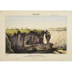
Southern - Concan.. - Nalkind or Kates Point..
Lithography representing a rocky landscape in the Western Ghats. Plate N° 12. From Souvenirs d'un voyage dans l'Inde, exécuté de 1834 à 1839, by A. Delessert.Adolphe ...
- $300 / ≈ €260
Date: Paris, 1843
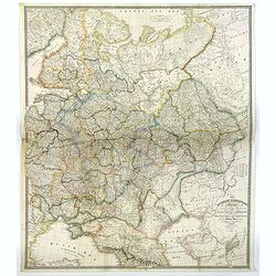
The Russian Dominions in Europe ... with the Post Roads & New Governments from the Russian Atlas of 1806 by Jasper Nantiat.
A two-sheet wall map of Russia covering from the Artic Sea to the Black and Caspian Seas and from East Prussia and Moldova to the Aral Sea and Tobolsk. Modern day nations...
- $500 / ≈ €433
Date: London, ca. 1843
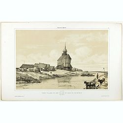
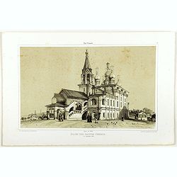
Vieux village et son église en bois du XIIIe siècle près de Rostow.
A view of an old village and its church. Figures are lithographed by Raffet. Plate taken from the first illustrated account of Russian architecture. This publication wa...
- $100 / ≈ €87
Date: Paris, 1844

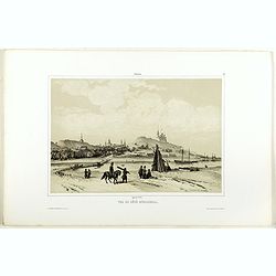
Village entre Novgorod et Tver.
A view of a village between Novgorod and Tver, as on 12 of August 1839. River Volga on foreground. Figures are lithographed by Raffet. Plate taken from the first illustra...
- $150 / ≈ €130
Date: Paris, 1844
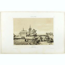
Vue de côté merodional.
A view of the village Vladimir. Figures are lithographed by Raffet. Plate taken from the first illustrated account of Russian architecture. This publication was the proje...
- $150 / ≈ €130
Date: Paris, 1844

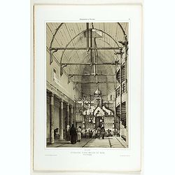
Intérieur de l'église du Monastère de la Ste Trinité.
A view of the Ste Trinity Monastery. Figures are lithographed by Raffet. Plate taken from the first illustrated account of Russian architecture. This publication was the ...
- $100 / ≈ €87
Date: Paris, 1844
Intérieur d'une église en bois, près de Kineschma.
A view of a church's inside, made of wood. Figures are lithographed by Raffet. Plate taken from the first illustrated account of Russian architecture. This publication wa...
- $100 / ≈ €87
Date: Paris, 1844

The church of Vasili Blagennoi Moscow.
Original steel engraving of St. Basil's Cathedral in Moscow, after a design by Alfred Gomersal Vickers (1810-1837) engraved by James Harfield Kernot (1802-1858).
- $20 / ≈ €17
Date: London and Paris, 1844
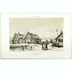
Village de Goumnisthe entre Kostroma et Yaroslaw..
A view of Goumnisthe village. Figures are lithographed by Raffet. Plate taken from the first illustrated account of Russian architecture. This publication was the project...
Date: Paris, 1844
Eglise des saintes femmes.
A view of a church, the 5 of September 1839. Figures are lithographed by Raffet. Plate taken from the first illustrated account of Russian architecture. This publication ...
Date: Paris, 1844
Nikolskoï paroisse entre les villes de Soudogda et Mouroum.
A view of an old church. Figures are lithographed by Raffet. Plate taken from the first illustrated account of Russian architecture. This publication was the project of C...
- $150 / ≈ €130
Date: Paris, 1844
Vue du côté méridional.
A view of an old village. Figures are lithographed by Raffet. Plate taken from the first illustrated account of Russian architecture. This publication was the project of ...
- $150 / ≈ €130
Date: Paris, 1844

ÉGLISE SAINT OUEN, A ROUEN. Dessiné d'après nature par Chapuy. Lith. par Deroy.
Original lithograph of Saint Ouen cathedral, situated in Rouen. Lithographed by Deroy after a design by Chapuy and printed in Paris by Lemercier, Bernard Cie.
- $125 / ≈ €108
Date: Paris, 1844

FACADE DE LA CATHÉDRALE A CHARTRES. Dessiné d'après nature par Chapuy. Lith. par Deroy.
Original lithograph of Chartres Cathedral's facade. Lithographed by Deroy after a design by Chapuy and printed in Paris by Lemercier, Bernard Cie.
- $125 / ≈ €108
Date: Paris, 1844

INTERIEUR DE L'EGLISE SAINT OUEN A ROUEN. Dessiné d'après nature par Chapuy. Lith. Par Arnout. Fig par Bayot.
Original lithograph of the inside of Saint Ouen chruch, situated in Rouen. Lithographed by Arnout and Adolphe-Jean-Baptist Bayot (Alessandria 1810 - 1866) after a design ...
- $50 / ≈ €43
Date: Paris, 1844

ÉGLISE St. VINCENT A ROUEN. Dessiné d'après nature par Chapuy. Lith. par Monthelier. Fig. par Bayot.
Original lithograph of St Vincent cathedral, situated in Rouen. Lithographed by Jules Monthelier (1801-1883) and Adolphe-Jean-Baptist Bayot (Alessandria 1810 - 1866) afte...
- $80 / ≈ €69
Date: Paris, 1844

TOMBEAU DU DUC DE BREZE, DANS LA CATHEDRALE DE ROUEN. Dessiné d'après nature par Chapuy. Lith. par Monthelier. Fig. par Bayot.
Original lithography of the tomb of the duke of Brézé, in the cathedral of Rouen. Lithographed by Jules Monthelier (1801-1883) and Adolphe-Jean-Baptist Bayot (Alessandr...
- $50 / ≈ €43
Date: Paris, 1844

INTERIEUR DE LA CATHEDRALE A CHARTRES. Dessiné d'après nature par Chapuy. Lith. Par Bachelier.
Original lithograph of the inside of the cathedral situated in Chartres. Lithographed by Bachelier after a design by Chapuy and printed in Paris by Lemercier, Bernard Cie...
- $50 / ≈ €43
Date: Paris, 1844
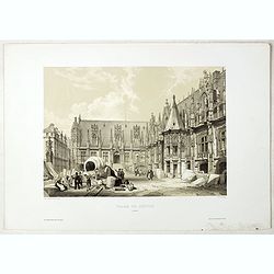
PALAIS DE JUSTICE A ROUEN. Dessiné d'après nature par Chapuy. Lith. par Rouargue.
Original lithograph of the courthouse of justice in Rouen. Lithographed by Rouargue after a design by Chapuy and printed in Paris by Lemercier, Bernard Cie.
- $150 / ≈ €130
Date: Paris, 1844

ARC DE TRIOMPHE A ORANGE. Dessiné d'après nature par Guesdon. Lith. par Ad. Cuvellier. Fig. par Bayot.
Original lithograph of the Triumph Arc of Orange. Lithographed by A. Cuvillier and Adolphe-Jean-Baptist Bayot (Alessandria 1810 - 1866) after a design by Chapuy and print...
- $100 / ≈ €87
Date: Paris, 1844

PORTAIL SEPTENTRIONAL DE LA CATHÉDRALE A CHARTRES. Dessiné d'après nature par Monthelier. Lith. par Monthelier.fig. par Bayot.
Original lithograph of the northern portal of Chartres cathedral. Lithographed by Jules Monthelier (1801-1883) and Adolphe-Jean-Baptist Bayot (Alessandria 1810 - 1866) af...
- $75 / ≈ €65
Date: Paris, 1844
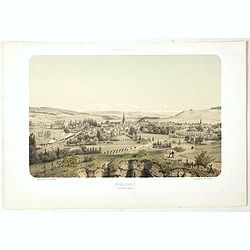
COMMERCY, Vue prise de la Garenne - Chemins de fer de l'Est. Dessiné d'après nat. et Lith. par A.Maugendre.
Original lithograph eye-bird view of Commercy, as seen from La Garenne. Lithographed by Jules Monthelier (1801-1883) and Adolphe-Jean-Baptist Bayot (Alessandria 1810 - 18...
Date: Paris, 1844
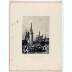
The church of Vasili Blagennoi Moscow.
Steel engraving of St. Basil's Cathedral in Moscow, after a design by Alfred Gomersal Vickers (1810-1837) engraved by James Harfield Kernot (1802-1858).
Date: London, 1844
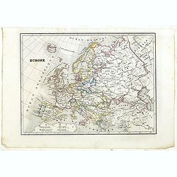
Europe.
Detailed Europe map, prepared by Charles V. Monin (fl.1830-1880) a French cartographer of Caen and Paris. Published in Atlas Universel de Géographie Ancienne &c Mode...
- $50 / ≈ €43
Date: Paris, 1845
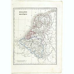
Hollande et Belgique.
Detailed Holland and Belgium map, prepared by Charles V. Monin (fl.1830-1880) a French cartographer of Caen and Paris. Published in Atlas Universel de Géographie Ancienn...
- $50 / ≈ €43
Date: Paris, 1845
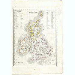
Iles Britanniques.
Detailed British Islands map, prepared by Charles V. Monin (fl.1830-1880) a French cartographer of Caen and Paris. Published in Atlas Universel de Géographie Ancienne &a...
- $25 / ≈ €22
Date: Paris, 1845
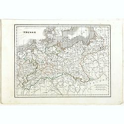
Prusse.
Detailed map of Prussia, prepared by Charles V. Monin (fl.1830-1880) a French cartographer of Caen and Paris. Published in Atlas Universel de Géographie Ancienne &c ...
- $40 / ≈ €35
Date: Paris, 1845
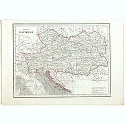
Empire d'Autriche.
Detailed map of Austria, prepared by Charles V. Monin (fl.1830-1880) a French cartographer of Caen and Paris. Published in Atlas Universel de Géographie Ancienne &c ...
- $25 / ≈ €22
Date: Paris, 1845
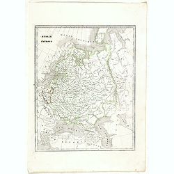
Russie d'Europe.
Detailed map of European Russia, prepared by Charles V. Monin (fl.1830-1880) a French cartographer of Caen and Paris. Published in Atlas Universel de Géographie Ancienne...
- $25 / ≈ €22
Date: Paris, 1845
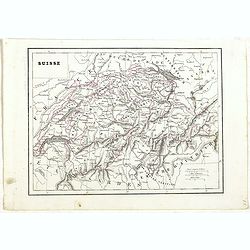
Suisse.
Detailed map of Switzerland, prepared by Charles V. Monin (fl.1830-1880) a French cartographer of Caen and Paris. Published in Atlas Universel de Géographie Ancienne &am...
- $45 / ≈ €39
Date: Paris, 1845
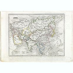
Asie.
Detailed map of Asia, prepared by Charles V. Monin (fl.1830-1880) a French cartographer of Caen and Paris. Published in Atlas Universel de Géographie Ancienne &c Mod...
- $50 / ≈ €43
Date: Paris, 1845
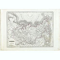
Sibérie ou Russie d'Asie.
Detailed map of Siberia, prepared by Charles V. Monin (fl.1830-1880) a French cartographer of Caen and Paris. Published in Atlas Universel de Géographie Ancienne &c ...
- $40 / ≈ €35
Date: Paris, 1845
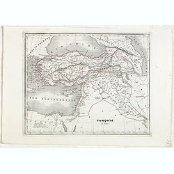
Turquie d'Asie.
Detailed map of Asian Turkey with Cyprus, prepared by Charles V. Monin (fl.1830-1880) a French cartographer of Caen and Paris. Published in Atlas Universel de Géographie...
- $45 / ≈ €39
Date: Paris, 1845
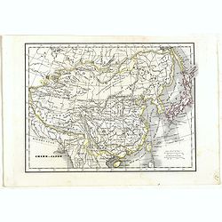
Chine et Japon.
Detailed map of China, Korea, Taiwan and Japan, prepared by Charles V. Monin (fl.1830-1880) a French cartographer of Caen and Paris. Published in Atlas Universel de Géog...
- $75 / ≈ €65
Date: Paris, 1845
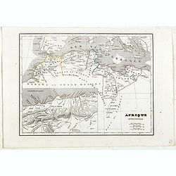
Afrique Septentrionale.
Detailed map of the Northern part of Africa, prepared by Charles V. Monin (fl.1830-1880) a French cartographer of Caen and Paris. Published in Atlas Universel de Géograp...
- $45 / ≈ €39
Date: Paris, 1845
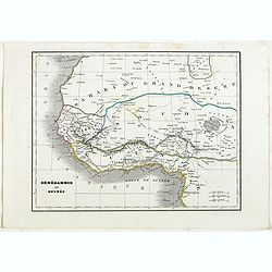
Sénégambie et Guinée.
Detailed map of the western part of Africa, prepared by Charles V. Monin (fl.1830-1880) a French cartographer of Caen and Paris. Published in Atlas Universel de Géograph...
- $45 / ≈ €39
Date: Paris, 1845
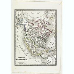
Amérique Septentrionale.
Detailed map of America, prepared by Charles V. Monin (fl.1830-1880) a French cartographer of Caen and Paris. Published in Atlas Universel de Géographie Ancienne &c ...
- $50 / ≈ €43
Date: Paris, 1845
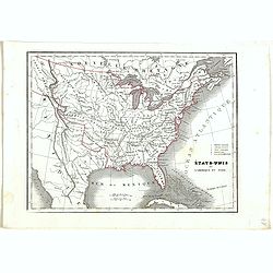
Etats-Unis de l'Amérique du nord.
Detailed map of North America, prepared by Charles V. Monin (fl.1830-1880) a French cartographer of Caen and Paris. Published in Atlas Universel de Géographie Ancienne &...
- $75 / ≈ €65
Date: Paris, 1845
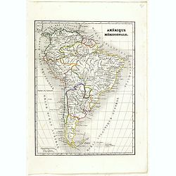
Amérique méridionale.
Detailed map of South America, prepared by Charles V. Monin (fl.1830-1880) a French cartographer of Caen and Paris. Published in Atlas Universel de Géographie Ancienne &...
- $45 / ≈ €39
Date: Paris, 1845
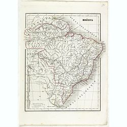
Brésil.
Detailed map of Brazil, prepared by Charles V. Monin (fl.1830-1880) a French cartographer of Caen and Paris. Published in Atlas Universel de Géographie Ancienne &c M...
- $45 / ≈ €39
Date: Paris, 1845
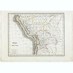
Pérou et Bolivia.
Detailed map of Peru and Bolivia, prepared by Charles V. Monin (fl.1830-1880) a French cartographer of Caen and Paris. Published in Atlas Universel de Géographie Ancienn...
- $45 / ≈ €39
Date: Paris, 1845
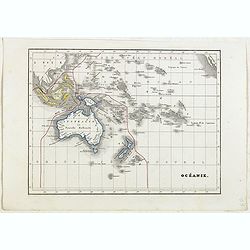
Océanie.
Detailed map of Oceania, including Indonesia and the Pacific Ocean with Hawaii, prepared by Charles V. Monin (fl.1830-1880) a French cartographer of Caen and Paris. Publi...
- $50 / ≈ €43
Date: Paris, 1845
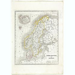
Suède, Norvège et Danemark.
Detailed map of Sweden, Norway and Denmark, prepared by Charles V. Monin (fl.1830-1880) a French cartographer of Caen and Paris. Published in Atlas Universel de Géograph...
- $35 / ≈ €30
Date: Paris, 1845
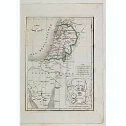
Carte de la Terre Sainte.
Detailed map of Israel, prepared by Charles V. Monin (fl.1830-1880) a French cartographer of Caen and Paris. Published in Atlas Universel de Géographie Ancienne &c M...
- $25 / ≈ €22
Date: Paris, 1845
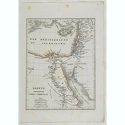
Egypte, Palestine, Syrie et Phoenicie.
Detailed map of Egypt, Palestine, Syria and Phoenicia, prepared by Charles V. Monin (fl.1830-1880) a French cartographer of Caen and Paris. Published in Atlas Universel d...
- $25 / ≈ €22
Date: Paris, 1845
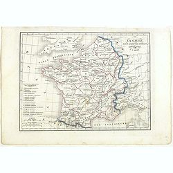
La Gaule sous l'Empire Romain.
Detailed map of France, prepared by Charles V. Monin (fl.1830-1880) a French cartographer of Caen and Paris. Published in Atlas Universel de Géographie Ancienne &c M...
- $25 / ≈ €22
Date: Paris, 1845
![[Shells] Planche 16.](/uploads/cache/14143-250x250.jpg)
[Shells] Planche 16.
An attractive collection of shells, from Jules-Sébastien-César Dumont d'Urville (1790-1842) Voyage au Pole Sud et dans l'Océanie sur les Corvettes L'Astrolabe et la Z�...
- $125 / ≈ €108
Date: Paris, 1846
![[Shells] Planche 9.](/uploads/cache/14145-250x250.jpg)
[Shells] Planche 9.
An attractive collection of shells. From Jules-Sébastien-César Dumont d'Urville (1790-1842) Voyage au Pole Sud et dans l'Océanie sur les Corvettes L'Astrolabe et la Z�...
- $150 / ≈ €130
Date: Paris 1846
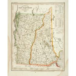
Neueste Karte von New Hampshire und Vermont.
Detailed map of New Hampshire and Vermont with numerous physical and political features including mines, settlements, trails/roads, forts and Indian areas. From Meijers H...
- $150 / ≈ €130
Date: Hildburghausen/ Philadelphia, 1846
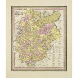
Russia in Europe.
From S. Augustus Mitchell’s "A New Universal Atlas". Philadelphia. Lithographic transfer from engraved plate. A fine map of Russia in Europe from the mid-nine...
- $80 / ≈ €69
Date: Philadelphia, c.1846
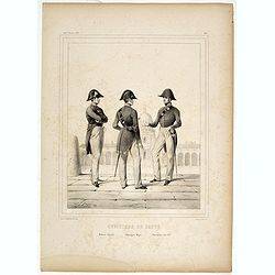
Officiers de santé. Médecin Adjoint - Chirurgien Major - Pharmacien Aide M.or.
Plate # 48 of the series "Uniformes de l'Armée Francaise en 1848", drawn and lithographed by Janet-Lange, printed by d'Aubert & C.ie. Figurs a medical offi...
- $50 / ≈ €43
Date: Paris, 1846
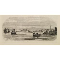
Der Hafen von Nangasaki auf Kiusiu.
A panoramic view of the harbour and city of Nagasaki with extensive shipping.
- $100 / ≈ €87
Date: Germany, 1847

Les temps sont durs, et il faut vivre dé privations cette anné ! . . . . A qui le dites-vous, mon cher Ducorneau . . . (Plate 2 from Tout ce qu'on voudra.)
Translation in English of title text: Times are difficult, this year we must learn to be more modest. . . - Don't tell me, my dear Ducorneau…. As far as I am concerned,...
Date: Paris, April 17, 1847
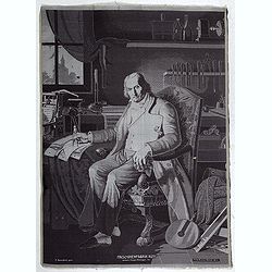
Maschinenfabrik Rüti, vormals Caspar Honegger tex.
Extremely rare woven silk portrait of Jean-Marie Jacquard drawn by Fritz Kaeser after the painting by C. Bonnefond, produced on the famous Honneger mechanical loom in Rü...
Date: Zürich, Rüti, ca. 1847
![[Untitled map of Black Sea].](/uploads/cache/37349-250x250.jpg)
[Untitled map of Black Sea].
Very detailed and rare map of Black Sea region. The map has elaborate floral borders. Prepared by Joseph Scheda in Vienna.
- $200 / ≈ €173
Date: Vienna, 1845-1847
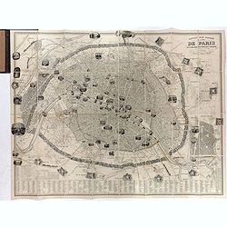
Nouveau plan illustré de la ville de Paris . . .
Fine plan of Paris, engraved by Taylor. "With the complete system of its fortifications and strong detached". Adorned with many vignettes engraved with monument...
- $900 / ≈ €779
Date: Paris, 1847
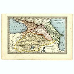
Armenia major, Iberia etc. by J.Archer.
Early Missionary map of Armenia from the "Atlas of educational maps for the use of schoolmasters" (1847), published by SPCK - the Society for Promoting Christia...
- $150 / ≈ €130
Date: London, 1847

Locataires et Propriétaires. Inconvénient de demander des réparations à son propriétaire. (Pl 24)
Locataires et Propriétaires [Tenants and Landlords], number 24: Inconvénient de demander des réparations à son propriétaire [Inconvenience of asking the landlord to ...
- $150 / ≈ €130
Date: Paris, Le Charivari, October 23, 1847