Browse Listings

Karsten Niebuhr.
Stipple engraved portrait of Carsten Niebuhr or Karsten Niebuhr (1733 – 1815), published in F. J. Bertuch "Allgemeine geographische Ephemeriden".Niebuhr was a...
Date: Weimar, 1810
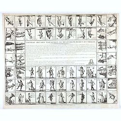
Nouveau jeu des théatres de Melpomene, Momus et Thalie.
Game board with 63 numbered pictorial compartments, each showing an actor or actress in role, lettered with his or her name, the name of the character, the play and the t...
- $1100 / ≈ €952
Date: Paris, ca. 1810
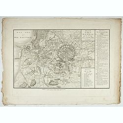
Accueil Consultation Plan du Siège de Danzig par le 10me. Corps de la Grande Armée, Avec les travaux des Français, tels qu'ils étaient le 25 Avril 1807.
A map of the siege of Danzig, 19 March-24 May 1807, showing the positions of the French siege works as they stood on 23 April. Napoleonic Wars (1803-15). Oriented with so...
Date: Paris, after 1810

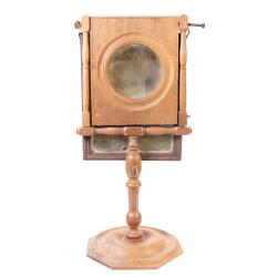
Elegant parlor Zograscope or optical mirror.
Rare so-called zograscope or optical mirror. A zograscope is an optical device for enhancing the sense of depth perception from a flat picture. It consists of a large mag...
- $1500 / ≈ €1298
Date: France or England, c. 1790-1810
Elegant parlor Zograscope or optical mirror.
Rare so-called zograscope or optical mirror. A zograscope is an optical device for enhancing the sense of depth perception from a flat picture. It consists of a large mag...
- $1500 / ≈ €1298
Date: France or England, c. 1790-1810
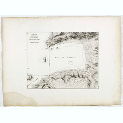
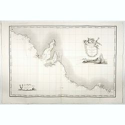
Esquisse de la Baie de Coupang (cote S.O. Ile de Timor) par M. M. Peron et Lesueur, an 1803.
Map of Kupang Bay on the Indonesian Island Timor, prepared by Louis Freycinet during his voyage under Captain Thomas Baudin in 1800-1803. Plate no. 14 from the atlas part...
- $100 / ≈ €87
Date: Paris, Langois, 1811
Carte Generale de la Terre Napoleon (à la Nouvelle Hollande)... par M.L. Freycinet an 1808.
Fine map of part of Australia prepared by Louis Freycinet during his voyage under Captain Thomas Baudin in 1800-1803. The longitude is calculated from Paris.The cartouche...
- $4000 / ≈ €3462
Date: Paris, Imprimerie Royale, 1811
Esquisse de la Baie de Coupang (cote S.O. Ile de Timor) par M. M. Peron et Lesueur, an 1803.
Map of Kupang Bay on the Indonesian Island Timor, prepared by Louis Freycinet during his voyage under Captain Thomas Baudin in 1800-1803. Plate no. 14 from the atlas part...
- $150 / ≈ €130
Date: Paris, Langois, 1811
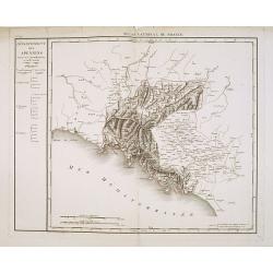
Département des Apennins Divisé en 3 Arrondissemens et en 18 cantons.
Published in the "Atlas National de France" at Chanlaire. Engraved by P.A.F. Tardieu. Represents the department of Apennines which was under French administrati...
Date: Paris, 1790-1811
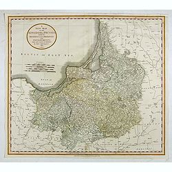
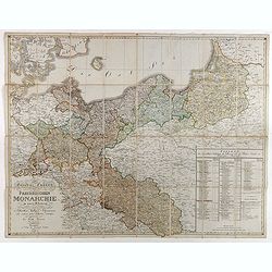
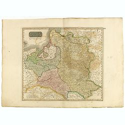
A New Map of the Kingdom of Prussia with its Divisions Into Provinces and Governments. . .
A fine map by John Cary of Prussia, in what is now northern Poland and Lithuania. John Cary was considered "the most representative, able and prolific of English car...
- $250 / ≈ €216
Date: London, 1811
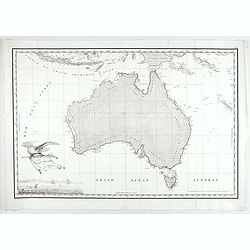
Carte Generale de la Nouvelle Hollande.
Fine map of the continent of Australia prepared by Louis Freycinet during his voyage under Captain Thomas Baudin in 1800-1803. Freycinet's map of New Holland was the firs...
- $5000 / ≈ €4327
Date: Paris, Imprimerie Royale, 1811

Voyage de découvertes aux Terres Australes. Historique. Atlas Deuxième partie.
First edition of the second part of the atlas by Freycinet, part of his important book "Voyage de découvertes aux Terres Australes". Illustrated with two foldi...
- $7500 / ≈ €6491
Date: Paris, Langlois, 1811
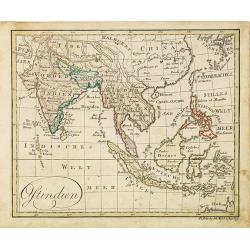
Ostindien.
Nice small map of South East Asia published by Johannes Walch in his rare Allgemeiner Atlas Nach den bewährsten Hülfsmitteln und astronomischen Ortsbestimungen…, edit...
- $160 / ≈ €138
Date: Augsburg, 1812
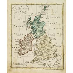
Grossbritanien und Irland.
Nice small map of the British isles and Ireland by Johannes Walch in his rare Allgemeiner Atlas Nach den bewährsten Hülfsmitteln und astronomischen Ortsbestimungen…, ...
- $50 / ≈ €43
Date: Augsburg, 1812
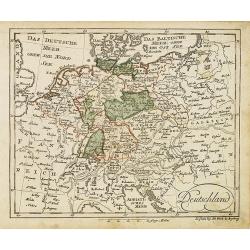
Deutschland (with Poland)
Nice small map of Germany by Johannes Walch in his rare Allgemeiner Atlas Nach den bewährsten Hülfsmitteln und astronomischen Ortsbestimungen…, edition of 1812.Johann...
- $75 / ≈ €65
Date: Augsburg, 1812
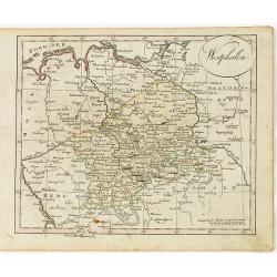
Westphalen.
Nice small map of Westphalia in Germany by Johannes Walch in his rare Allgemeiner Atlas Nach den bewährsten Hülfsmitteln und astronomischen Ortsbestimungen…, edition ...
- $50 / ≈ €43
Date: Augsburg, 1812
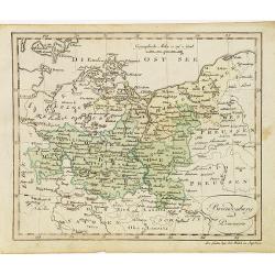
Brandenburg und Pommern.
Nice small map of Brandenburg and Pommeren, centered on Berlin by Johannes Walch in his rare Allgemeiner Atlas Nach den bewährsten Hülfsmitteln und astronomischen Ortsb...
- $75 / ≈ €65
Date: Augsburg, 1812
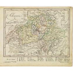
Schweiz.
Nice small map of Switzerland by Johannes Walch in his rare Allgemeiner Atlas Nach den bewährsten Hülfsmitteln und astronomischen Ortsbestimungen…, edition of 1812.Jo...
- $60 / ≈ €52
Date: Augsburg, 1812
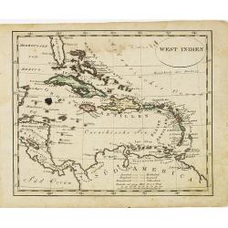
West indien.
Nice small map of The West Indies, with Cuba, Jamaica, S.Domingo, etc. Southern tip of Florida is included. Map by Johannes Walch in his rare Allgemeiner Atlas Nach den b...
Date: Augsburg, 1812
![[No Tittle] Map of the Easteren Hemisphere.](/uploads/cache/29385-250x250.jpg)
[No Tittle] Map of the Easteren Hemisphere.
Nice small map of eastern hemisphere by Johannes Walch in his rare Allgemeiner Atlas Nach den bewährsten Hülfsmitteln und astronomischen Ortsbestimungen…, edition of ...
- $120 / ≈ €104
Date: Augsburg, 1812
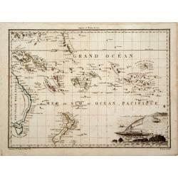
Océanique Oriente.
Drom the Carolines to New Zealand and east to Pitcairn Island with Australia from Torres Strait to Tasmania. Engraved by J.B.Tardieu and prepared by Giraldon.From Conrad ...
- $300 / ≈ €260
Date: Paris, 1809/1812
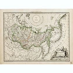
Sibérie avec l'Amérique Russe.
Prepared by Pierre Lapie and published by François Buisson and included in "Atlas Complet Du Precis De La Geographie Universelle De M. Malte-Brun". Engraved by...
- $120 / ≈ €104
Date: Paris, 1812
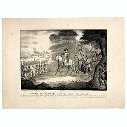
Entrée des Français dans la ville de Moscou . . .
View of the French's army entering Moscow on 14 September 1812 during the Napoleonic Wars (1800-1815) in Russia.
- $75 / ≈ €65
Date: Brussels, ca. 1812
![[assorted Chinese musical instruments].](/uploads/cache/37968-250x250.jpg)
[assorted Chinese musical instruments].
A delightful copperplate print of 15 assorted Chinese musical instruments including gong, bell, drum, cymbals etc.
- $35 / ≈ €30
Date: Germany, ca. 1812
![[assorted Chinese musical instruments].](/uploads/cache/37969-250x250.jpg)
[assorted Chinese musical instruments].
A delightful copperplate print of 15 assorted Chinese musical instruments including violin, flute, trumpet, guitars, cymbals etc.
- $30 / ≈ €26
Date: Germany, ca. 1812
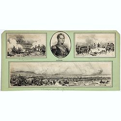
Passage de la Berezinas.
Set of four views of The Battle of Berezina (or Beresina) which took place from 26 to 29 November 1812, between the French army of Napoleon, retreating after his invasion...
Date: ca. 1812

Carte des routes de poste de la Russie européenne, exécutée par ordre de S.E.M. le duc de Feltre ministre de la Guerre, ...
Post-route map on a scale of 1:2 500 000 made during the French campaign in Russia, which began June 24, 1812. With a table of the conventional signs and a table of conve...
Date: Paris, Dépôt Général de la Guerre 1812
General Charte der Preussischen Monarchie in zwey Blattern. . .
Uncommon and detailed map of Kingdom of Prussia with present day Poland and Germany. Uncommon map engraved by Ludwig Hess and published in Weimar by Fr. Wilhelm Streit.
- $1000 / ≈ €865
Date: Weimar, 1812
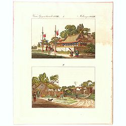
Verm Gegenstaende. CXIII. 1 Melandes CCXIII.
A Chinese Mandarin house and below a Chinese village scene with farmers.
- $50 / ≈ €43
Date: Germany, 1812
Amerique ou Indes Occidentales..
Fine map of the Western Hemisphere with on right hand side geographical index tables with also mentioning the Spanish, English, French, Danish possessions. Prepared by Ro...
Date: Paris, 1812
![Ansicht von Megasaky. [Nagasaki - title also in Russian characters]](/uploads/cache/24829-250x250.jpg)
Ansicht von Megasaky. [Nagasaki - title also in Russian characters]
The print shows Nagasaki harbor with n the foreground the Russian delegation with Krusenstern in a boat with 3 Chinese. Japanese junks and the town of Nagasaki in the ba...
- $1500 / ≈ €1298
Date: St.Petersburg, 1810-1814
![Ansicht der stadt Nangasaky. [Nagasaki - title also in Russian characters]](/uploads/cache/24839-250x250.jpg)
Ansicht der stadt Nangasaky. [Nagasaki - title also in Russian characters]
A lively scene in Nagasaki harbor. In the foreground, Japanese junks and the town of Nagasaki in the background, with the warehouses on Deshima, the trading post of the D...
- $3000 / ≈ €2596
Date: St.Petersburg, 1810-1814
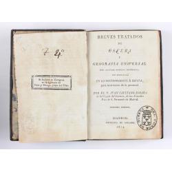
Breves tratados de esfera y geografía universal, con algunas noticias históricas, en especial en lo perteneciente a España, para instruccion de la juventud.
Third edition of this popular Spanish Atlas for children, illustrated with 6 folding engraved "blind" maps, all finely colored by hand, in the main part in orig...
- $750 / ≈ €649
Date: Madrid, Impreta de Collado, 1814
Smolensko.
View of this small town in Russia just before the First Battle of Smolensk which took place on August 17, 1812, between 175,000 men of the army under Napoleon Bonaparte a...
- $225 / ≈ €195
Date: London, 1814
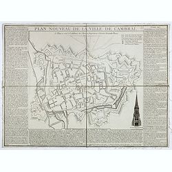
Plan nouveau de la ville de Cambrai.
Nice town-plan of Cambrai, with its fortifications and the citadel, decorated with the cathedral in lower right corner. The borders contain a historical description of th...
Date: Cambrai, 1814

Juan II Jvanovitz, il monta sur le trône en 1353, et mourut en 1358.
Portrait of Juan II Jvanovitz., engraved by Louis Legrand (1723-1807).
- $50 / ≈ €43
Date: Paris, 1814
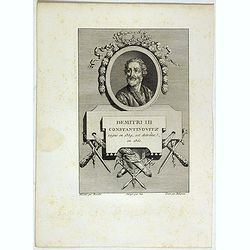
Demitri III Constantinovitz, regne en 1359, est detrône en 1361.
Portrait of Demitri III Constantinovitz., Grand Duke of Russia, engraved by C.-N. Malapeau.
- $75 / ≈ €65
Date: Paris, 1814
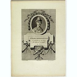
Fédor Borissovitz il succéda a son père, fut détroné et étouffé en 1505.
Portrait of Fédor Borissovitz. (1589 - 1605), engraved by Louis Pauquet (1759-1824).
- $75 / ≈ €65
Date: Paris,1814
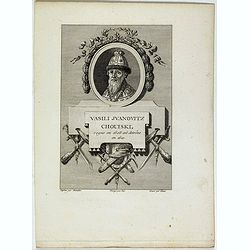
Vasili Juanovitz Chouiski regne en 1606 est detrône en 1610.
Portrait of Vasili Juanovitz Chouiski or Vasili IV of Russia (1552 – 1612) was Tsar of Russia between 1606 and 1610 after the murder of False Dmitriy I. His reign fell ...
- $45 / ≈ €39
Date: Paris, 1814
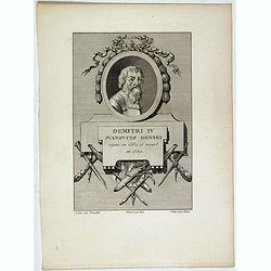
Demitri IV Juanovitz Donski regne en 1362, et meurt en 1389.
Portrait of Demitri IV Juanovitz or Vasili IV of Russia who was Tsar of Russia between 1606 and 1610 after the murder of False Dmitriy I. His reign fell during the Time o...
- $75 / ≈ €65
Date: Paris, 1814
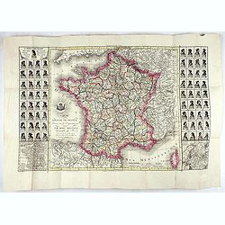
Carte du royaume de France divisé en 87 départemens / dressée par Brion de la Tour..., où sont tracées les nouvelles limites fixées par le traité de paix du 30 mai 1814. . .
Very decorative and uncommon map of France, with Corsica prepared by Brion de la Tour showing the new border set by the Peace Treaty of May 30, 1814. Engraved by Chaumier...
Date: Paris, ca. 1814

The World, Surrounded with Emblematical Figures of Europe, Asia, Africa, & America.
Fine title page showing a globe surrounded with emblematical figures of Europe, Asia, Africa, & America. From 'Kelly's System of Geography'.
- $300 / ≈ €260
Date: London, 1815
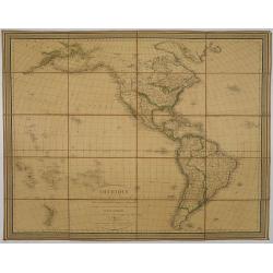
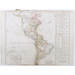
Amérique, réduite d'après celles d'Arrowsmith en 4 flles Par J.N.Champion, Ingénieur-Geographe et . . . Nouvelles découvertes de Clacke et du Major Pike . . .
A charming folding-map of America, drawn by J.N. Champion. The title explains that the map used the latest information by Alexander Humboldt and Clarck and Pike. Dated 18...
- $500 / ≈ €433
Date: Paris, 1815
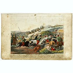
Gefecht bei Daoughelichki, den July 1812.
Rare German print showing the siege of Daoughelichki, July 1812, during the French Russian Campaign, which ended in Napoleon's defeat.
- $150 / ≈ €130
Date: Nuremberg, ca. 1815
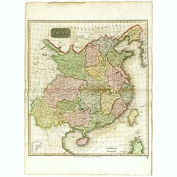
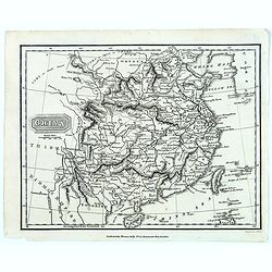
China.
Highly detailed map of China including Formosa (Taiwan), Hainan, and part of Luzon in the Philippines. The map show the Tract of the Hindoostan and Lion with the British ...
Date: Edinburgh, 1815
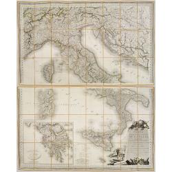
Carte Statistique, Politique, et Mineralogique de l'Italie o'u sont tracées toutes les routes, relais, et distances de postes. . .(2 Maps)
Folding map, extending west to east from Monaco to Otranto and north to south from The Alps to Malta, inset of Greece,. Cartouche depicting Rome and her classical past. P...
Date: Paris, 1816
![Plan d'une partie de la Terre Napoléon [with] Plan des Iles Joséphine et de la Baie Murat.](/uploads/cache/46367-250x250.jpg)
Plan d'une partie de la Terre Napoléon [with] Plan des Iles Joséphine et de la Baie Murat.
Two maps showing Descartes Bay and Bridgewater Bay in Victoria and Murat Bay in South Australia showing French discoveries prepared by Louis Freycinet during his voyage u...
- $100 / ≈ €87
Date: Paris, 1807-1816
![Plan des Iles Jérôme [with] Plan des Iles Berthier [with] Plan du Comté de Cumberland.](/uploads/cache/46370-250x250.jpg)
Plan des Iles Jérôme [with] Plan des Iles Berthier [with] Plan du Comté de Cumberland.
Three maps on one sheet, Jérôme islands, Berthier islands and Cumberland county, from Voyage de découvertes aux terres Australes by François Péron, 1824. The French ...
- $100 / ≈ €87
Date: Paris, 1807-1816
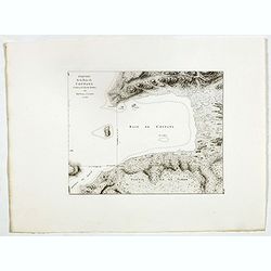
![Plan du Port du Roi-George [with] Plan de la Baie du Geographe.](/uploads/cache/46371-250x250.jpg)
Plan du Port du Roi-George [with] Plan de la Baie du Geographe.
Two maps on one sheet, King George Sound and Geographe Bay, now Busselton and Dunsborough area and the earliest chart of this area, from Voyage de découvertes aux terres...
- $500 / ≈ €433
Date: Paris, 1807-1816
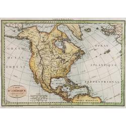
Carte d' Amérique Septentrionale 1817.
Map of North and Central America. Engraved by E.Collin, active at 23, quai des Augustins, Paris.
- $300 / ≈ €260
Date: Paris, 1817
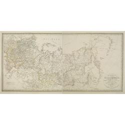
Charte des ganzen Russischen Reichs in Europa und Asien : Nach den neuesten und sichersten astronomischen Ortsbestimmungen entworfen und berichtiget auf der Sternwarte Seeberg bey Gotha gezeichnet von I. C. M. Reinecke. . .
Uncommon two-sheet map of Russia, prepared by Johann Matthias Christoph Reinecke (1770-1818). The map's information is off by 20 degrees longitude as the prime meridian ...
Date: Weimar, 1817
Nouveau voyage pittoresque de la France Orné de trois cent soixante gravures exécutées sur des dessins fait d'après nature, et représentant des Vues des principales Villes de France, ...
Large paper copy, printed on quarto format (210x235mm.) on heavy paper. Illustrated with 360 engraved plates, many by Jean-Jerome Baugean. Without the large folding map....
- $2200 / ≈ €1904
Date: Paris, 1817
China.
From the atlas the 'Universal Geography' by Thos. Kelly, and engraved by Finlay. This copper plate maps shows the mainland of China, together with the islands of Formosa ...
Date: London, ca. 1817
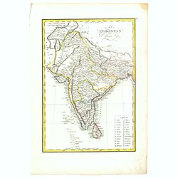
El Indostan por D. Juan Lopez.
Uncommon map of India and Shri Lanka published by Juan Lopez (1765-1830) and included in his "Atlas Universal o collection de mapas nuevos. . ." first published...
- $375 / ≈ €325
Date: Madrid, 1817
Poland As Divided.
This map covers Poland following Napoleonic Wars and the treaties of the 1815 Congress of Vienna.This map was first published in Thomson's New General Atlas of 1814. John...
Date: Edinburgh, 1817
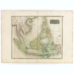
East India Isles.
Somewhat later but very finely engraved and detailed map of the Indonesian archipelago, including Thailand, Philippines and southern part of Taiwan.
Date: Edinburgh, 1817
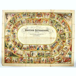
The Royal Game of British Sovereigns Exhibiting the Most Remarkable Events in Each Reign From Egbert to George III,
Engraved goose game with 53 illustrations culminating in a view of Napoleon on the Bellerophon, four further spandrel vignettes, and a central oval filled with title and ...
- $900 / ≈ €779
Date: London, ca. 1817
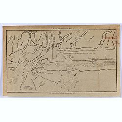
Little Egg Harbour.
A small sea chart showing Little Egg Harbour east of Tucker's Island. This map was published in the “American Coast Pilot”, a detailed guide to harbors, capes and hea...
- $50 / ≈ €43
Date: New York, 1817

Mellon Scarlet fresh Rock.
Color aquatint and stipple engraved plate of fruits by George Brookshaw (1751-1823) from his "Pomona Britannica; or, a Collection of the most esteemed fruits at pres...
Date: London, Bensley and son, 1817

Quartett.
Engraved by Joseph Stöber, (born in Vienna 13. June 1768, died 12 March 1852) after design of Matthäus Loder (1781-1828). From Castelli, "Zerrbilder menschlicher T...
Date: Wien, 1818

Karten Sibylle.
Engraved by Joseph Stöber, (born in Vienna 13. June 1768, died 12 March 1852) after design of Matthäus Loder (1781-1828). From Castelli, "Zerrbilder menschlicher T...
Date: Wien, 1818

Pferde Liebhaberey.
Engraved by Joseph Stöber, (born in Vienna 13. June 1768, died 12 March 1852) after design of Matthäus Loder (1781-1828). From Castelli, "Zerrbilder menschlicher T...
Date: Wien, 1818

Eifersucht.
Engraved by Joseph Stöber, (born in Vienna 13. June 1768, died 12 March 1852) after design of Matthäus Loder (1781-1828). From Castelli, "Zerrbilder menschlicher T...
Date: Wien, 1818
Abbozzo della mappa dei viaggi di Marco Polo nella sala dello Scudo del Palazzo ducale di Venezia.
Rare map showing the travels of Marco Polo, taken from "Sulle antiche mappe idro-geografiche lavorate in Venezia: Commentario.", by Placido Zurla (1769-1834), p...
Date: Venice, 1818
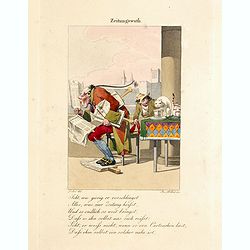
Zeitungswuth.
Engraved by Joseph Stöber, (born in Vienna 13. June 1768, died 12 March 1852) after design of Matthäus Loder (1781-1828). From Castelli, "Zerrbilder menschlicher T...
- $150 / ≈ €130
Date: Wien, 1818
Situations = Plan. Der gegend zwischen der Kayserlich Königlichen Granitz Festung Essegg, und dem Dorffe Bellia....
Manuscript plan showing the Kopački Rit nature park a swampy area of Baranja between Osijek (Essegg) and Bilje. The river Drava in upper right corner. The pen an...
Date: Vienna, 1819

Anti-dandy infantry triumphant or the velocipede cavalry unhobby'd. (pl 353)
Scene on a high-road passing through a village. Those who see their livelihood threatened by mechanical transport attack the riders of velocipedes. In the foreground a di...
Date: London, 1819
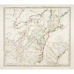
Gedeelte van den Vereenigden Staat van Noord Amerika.
A rare an detailed map of the eastern part of the United States of America. After Isaac Weld's map from his Travels through the States of North America 1799. Barbara Back...
- $650 / ≈ €563
Date: Netherlands c. 1820

Coiffure ornee de marabouts. . . (1875)
From Costume Parisien (1797-1839).Paris was the capital for fashion innovation and design. After the final defeat of Napoleon, English and French fashions merged to close...
Date: Paris, 1820
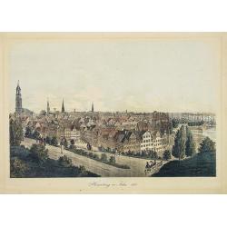
Hamburg im Jahre 1813
Decorative lithographed view of Hamburg. The print is issued in colors but finished by hand.
- $150 / ≈ €130
Date: Germany,1820
![[No tittle] Partie de la Prusse.](/uploads/cache/30632-250x250.jpg)
[No tittle] Partie de la Prusse.
Detailed map of the south of Baltic Sea. With a paper printed label of the Paris map seller Jean Goujon who was active from 1793-1826. The label carries the address of Ru...
- $90 / ≈ €78
Date: Paris, c. 1820
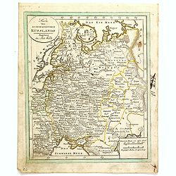
Karte des Europaeischen Russland. . ..
Nice small map of Russia.
- $100 / ≈ €87
Date: Augsburg, 1820
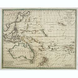
Australien (Südland) auch Polynesien oder Inselwelt..
SECOND EDITION of the Johann Walch map of Australasia and the South Pacific. Australia lettered Neu Holland, the name given to it by Able Tasman that was still in use un...
Date: Augsburg, 1802-1820
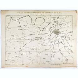
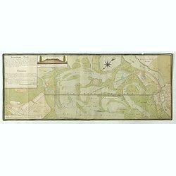
Tableau d'assemblage de la carte des environs de Versailles dite chasses impériales.
Key sheet to the rare 12 sheet map "Carte topographique des environs de Versailles dite des Chasses Impériales, levée et dressée de 1764 à 1773 par les ingénieu...
Date: Paris, ca. 1820
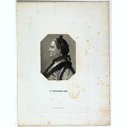
Catharina II.
Portrait of Catharina II (1729-1796) or Catherine the Great, Empress of Russia. During the reign of the flamboyant and powerful Empress Catherine II of Russia, whose long...
- $60 / ≈ €52
Date: Germany, ca. 1820
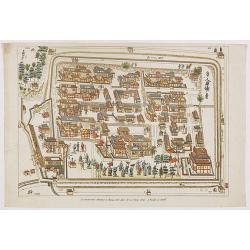
La factorerie chinoise a nagasaki, dans la rue Teng-chan (fondée en 1688).
The Chinese traders at Nagasaki were confined to a walled compound which was located in the same vicinity as Dejima island; and the activities of the Chinese, though less...
- $500 / ≈ €433
Date: Paris, A. Nepveu, 1820
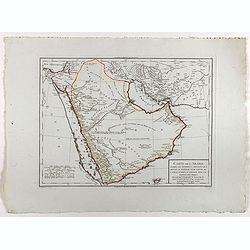
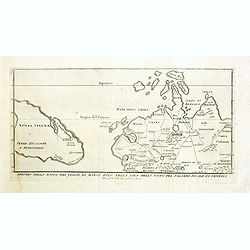
Carte de l'Arabie d'après les différents morceaux qu'a donnés M. Niebuh...
Detailed map of the Arabian peninsular, after Niebuhr, with scales in lower left corner. Engraved by Pierre-Paul Dubuisson.More about Mapping of Arabia [+]
Date: Paris, ca. 1820
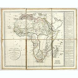
Carte générale de L'Afrique divisée en ses principaux états par Fx Delamarche. . .
Uncommon map of Africa prepared by Felix Delamarche, after R.de Vaugondy. The "Zahara ou Grand désert" and Congo and Zambia "Contrée tout-a-fait Inconnue...
- $300 / ≈ €260
Date: Paris, 1820
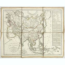
Carte générale de L'asie . . .
Uncommon map of Asia prepared by Felix Delamarche, after R.de Vaugondy. In the right hand a lengthy description of geographical details of the different European countrie...
Date: Paris, 1820