Browse Listings
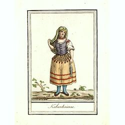
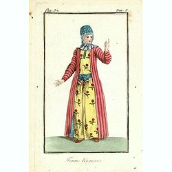
Kabardinienne.
Originally hand-colored costume mezzotint of a Kabardian woman from the Northwest Caucasus, engraved by Félix Mixelle and Lachaussée Jeune after Jacques Grasset de Sain...
Date: Paris,1801-1806
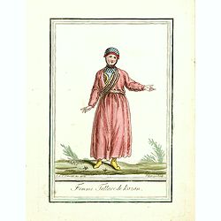
Femme Tattare de Kazan.
Originally hand-colored costume mezzotint of a Kazakhstan women engraved by Félix Mixelle and Lachaussée Jeune after Jacques Grasset de Saint-Sauveur.As an etcher, draw...
Date: Paris,1801-1806
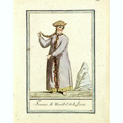
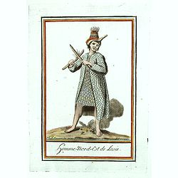
Femme du nord est de l'Asie.
Originally hand-colored mezzotint of a woman from Nord East Russia engraved by Félix Mixelle and Lachaussée Jeune after Jacques Grasset de Saint-Sauveur.As an etcher, d...
Date: Paris,1801-1806
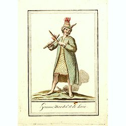
Homme nord est de l'Asie.
Originally hand-colored mezzotint of Native Americans engraved by Félix Mixelle and Lachaussée Jeune after Jacques Grasset de Saint-Sauveur.As an etcher, drawer and wri...
- $50 / ≈ €43
Date: Paris,1801-1806
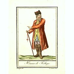
Homme de Kaluga.
Originally hand-colored costume mezzotint of a man from Kaluga engraved by Félix Mixelle and Lachaussée Jeune after Jacques Grasset de Saint-Sauveur.As an etcher, drawe...
Date: Paris,1801-1806
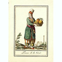
Femme de la Carie.
Originally hand-colored mezzotint costume plate of a woman from the Republic of Karelia, engraved by Félix Mixelle and Lachaussée Jeune after Jacques Grasset de Saint-S...
Date: Paris,1801-1806
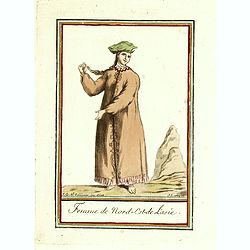
Femme de nord ets de l'Asie.
Originally hand-colored mezzotint of a woman from Nord West Asia engraved by Félix Mixelle and Lachaussée Jeune after Jacques Grasset de Saint-Sauveur.As an etcher, dra...
Date: Paris,1801-1806
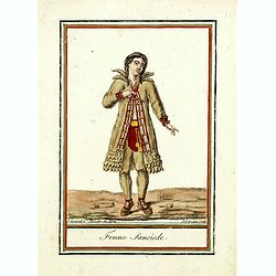
Femme Samoïede.
Originally hand-colored mezzotint of a Samoïede woman engraved by Félix Mixelle and Lachaussée Jeune after Jacques Grasset de Saint-Sauveur.As an etcher, drawer and wr...
Date: Paris,1801-1806
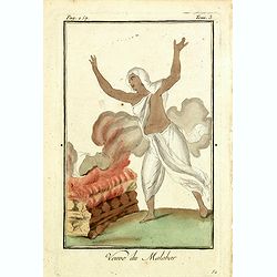
Venue du Malabar.
Originally hand-colored mezzotint of a widow of Malabar engraved by Félix Mixelle and Lachaussée Jeune after Jacques Grasset de Saint-Sauveur.As an etcher, drawer and w...
Date: Paris,1801-1806
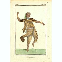
Bayadere.
Originally hand-colored mezzotint of a Temple Dancer engraved by Félix Mixelle and Lachaussée Jeune after Jacques Grasset de Saint-Sauveur.As an etcher, drawer and writ...
Date: Paris,1801-1806
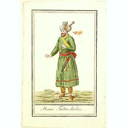
Homme Tartare d'Usbec.
Originally hand-colored costume mezzotint of a man from Uzbekistan engraved by Félix Mixelle and Lachaussée Jeune after Jacques Grasset de Saint-Sauveur.As an etcher, d...
Date: Paris,1801-1806
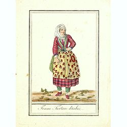
Femme Tartare d'Usbec.
Originally hand-colored costume mezzotint of a woman from Uzbekistan engraved by Félix Mixelle and Lachaussée Jeune after Jacques Grasset de Saint-Sauveur.As an etcher,...
Date: Paris,1801-1806
Homme-nord-est de l'Asie.
Originally hand-colored costume mezzotint of a man of Nord East Russia engraved by Félix Mixelle and Lachaussée Jeune after Jacques Grasset de Saint-Sauveur.As an etche...
- $25 / ≈ €22
Date: Paris,1801-1806
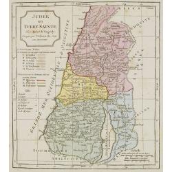
Judée ou Terre Sainte.
Map of the Holy Land, Judea. By C. F. Delamarche, successor of Robert de Vaugondy, Geographer.
- $75 / ≈ €65
Date: Paris, 1794 -1806
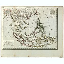
Presqu'Île au dela du Gange et Archipel de l'Inde.
Detailed map of Indonesia with Philippines and Taiwan. Engraved by P.F.Tardieu. From "Mentelle's Atlas Universe".
- $150 / ≈ €130
Date: Paris, ca 1784 / 1806
![Fille Mordwine en habits de nôces [together with] Fille Mordwine.](/uploads/cache/36932-250x250.jpg)
Fille Mordwine en habits de nôces [together with] Fille Mordwine.
Set of two originally hand-colored mezzotints of Native Russians engraved by Félix Mixelle and Lachaussée Jeune after Jacques Grasset de Saint-Sauveur.As an etcher, dra...
- $50 / ≈ €43
Date: Paris,1801-1806
![Femme Baschkir [together with] Homme Baschkir.](/uploads/cache/36933-250x250.jpg)
Femme Baschkir [together with] Homme Baschkir.
Set of two originally hand-colored mezzotints of Native Russians engraved by Félix Mixelle and Lachaussée Jeune after Jacques Grasset de Saint-Sauveur.As an etcher, dra...
- $50 / ≈ €43
Date: Paris,1801-1806
![Kirguise [together with] Fille Fatar Kastchintz.](/uploads/cache/36937-250x250.jpg)
Kirguise [together with] Fille Fatar Kastchintz.
Set of two originally hand-colored mezzotints of Native Russians engraved by Félix Mixelle and Lachaussée Jeune after Jacques Grasset de Saint-Sauveur.As an etcher, dra...
- $50 / ≈ €43
Date: Paris,1801-1806
![Homme Fatar Kastchintz [together with] Femme Fatar Kastchintz.](/uploads/cache/36938-250x250.jpg)
Homme Fatar Kastchintz [together with] Femme Fatar Kastchintz.
Set of two originally hand-colored mezzotints of Native Russians engraved by Félix Mixelle and Lachaussée Jeune after Jacques Grasset de Saint-Sauveur.As an etcher, dra...
- $50 / ≈ €43
Date: Paris,1801-1806
![Homme de Tobolsk [together with] Femme Fatar Tobolsk.](/uploads/cache/36939-250x250.jpg)
Homme de Tobolsk [together with] Femme Fatar Tobolsk.
Set of two originally hand-colored mezzotints of Native Russians engraved by Félix Mixelle and Lachaussée Jeune after Jacques Grasset de Saint-Sauveur.As an etcher, dra...
- $50 / ≈ €43
Date: Paris,1801-1806
![Homme Morwine [together with] Femme Mordwine.](/uploads/cache/36920-250x250.jpg)
Homme Morwine [together with] Femme Mordwine.
Set of two originally hand-colored mezzotints of Native Russians engraved by Félix Mixelle and Lachaussée Jeune after Jacques Grasset de Saint-Sauveur.As an etcher, dra...
- $50 / ≈ €43
Date: Paris,1801-1806
![Femme Tscheremisse [together with] Homme Tscheremisse.](/uploads/cache/36921-250x250.jpg)
Femme Tscheremisse [together with] Homme Tscheremisse.
Set of two originally hand-colored mezzotints of Native Russians engraved by Félix Mixelle and Lachaussée Jeune after Jacques Grasset de Saint-Sauveur.As an etcher, dra...
- $50 / ≈ €43
Date: Paris,1801-1806
![Homme Kamtschadale [together with] Femme Kamtschadale.](/uploads/cache/36922-250x250.jpg)
Homme Kamtschadale [together with] Femme Kamtschadale.
Set of two originally hand-colored mezzotints of Native Russians engraved by Félix Mixelle and Lachaussée Jeune after Jacques Grasset de Saint-Sauveur.As an etcher, dra...
Date: Paris,1801-1806
![Femme Samoïede [together with] Homme Samoïede.](/uploads/cache/36923-250x250.jpg)
Femme Samoïede [together with] Homme Samoïede.
Set of two originally hand-colored mezzotints of Native Russians engraved by Félix Mixelle and Lachaussée Jeune after Jacques Grasset de Saint-Sauveur.As an etcher, dra...
- $50 / ≈ €43
Date: Paris,1801-1806
![Femme Ostyack [together with] Homme Ostyack.](/uploads/cache/36924-250x250.jpg)
Femme Ostyack [together with] Homme Ostyack.
Set of two originally hand-colored mezzotints of Native Russians engraved by Félix Mixelle and Lachaussée Jeune after Jacques Grasset de Saint-Sauveur.As an etcher, dra...
- $50 / ≈ €43
Date: Paris,1801-1806
![Kabardinien [together with] Kabardinienne.](/uploads/cache/36925-250x250.jpg)
Kabardinien [together with] Kabardinienne.
Set of two originally hand-colored mezzotints of Native Russians engraved by Félix Mixelle and Lachaussée Jeune after Jacques Grasset de Saint-Sauveur.As an etcher, dra...
- $50 / ≈ €43
Date: Paris,1801-1806
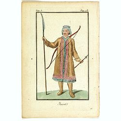
![Homme Jacout [together with] Femme Jacout.](/uploads/cache/36928-250x250.jpg)
Homme Jacout [together with] Femme Jacout.
Set of two originally hand-colored mezzotints of Native Russians engraved by Félix Mixelle and Lachaussée Jeune after Jacques Grasset de Saint-Sauveur.As an etcher, dra...
- $50 / ≈ €43
Date: Paris,1801-1806
![Homme Tongouse [together with] Femme Tongouse.](/uploads/cache/36929-250x250.jpg)
Homme Tongouse [together with] Femme Tongouse.
Set of two originally hand-colored mezzotints of Native Russians engraved by Félix Mixelle and Lachaussée Jeune after Jacques Grasset de Saint-Sauveur.As an etcher, dra...
- $50 / ≈ €43
Date: Paris,1801-1806
![Femme de Tschutskÿ [together with] Homme de Tschutskÿ.](/uploads/cache/36930-250x250.jpg)
Femme de Tschutskÿ [together with] Homme de Tschutskÿ.
Set of two originally hand-colored mezzotints of Native Russians engraved by Félix Mixelle and Lachaussée Jeune after Jacques Grasset de Saint-Sauveur.As an etcher, dra...
- $50 / ≈ €43
Date: Paris,1801-1806
![Fille Barabinze [together with] Homme Barabinze.](/uploads/cache/36931-250x250.jpg)
Fille Barabinze [together with] Homme Barabinze.
Set of two originally hand-colored mezzotints of Native Russians engraved by Félix Mixelle and Lachaussée Jeune after Jacques Grasset de Saint-Sauveur.As an etcher, dra...
- $50 / ≈ €43
Date: Paris,1801-1806
![Femme de Nord-Est-de l'Asie [together with] Homme-Nord-Est de l'Asie.](/uploads/cache/36935-250x250.jpg)
Femme de Nord-Est-de l'Asie [together with] Homme-Nord-Est de l'Asie.
Set of two originally hand-colored mezzotints of Native Russians engraved by Félix Mixelle and Lachaussée Jeune after Jacques Grasset de Saint-Sauveur.As an etcher, dra...
- $50 / ≈ €43
Date: Paris,1801-1806
![Indous [together with] Habitants de la Carie.](/uploads/cache/36936-250x250.jpg)
Indous [together with] Habitants de la Carie.
Set of two originally hand-colored mezzotints of Native Russians engraved by Félix Mixelle and Lachaussée Jeune after Jacques Grasset de Saint-Sauveur.As an etcher, dra...
- $50 / ≈ €43
Date: Paris,1801-1806
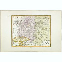
Partie Méridionale de la Russie Européenne, Tartarie, Russienne, Petite Tartarie.
Map of the southern part of Russia and Tartary. The Caspian Sea in lower right corner. By C. F. Delamarche, successor of Robert de Vaugondy, Geographer.
- $50 / ≈ €43
Date: Paris, 1806
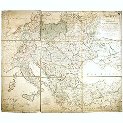
THEATRE Géographique des Guerres du Continent, OU SE TROUVENT EN ENTIER Les Royaumes de Hollande, ...
Large wall map of Central Europe, centered on Poland and including present-day Germany, the Low Countries, Italy, Greece, Bulgaria, Turkey and the Black Sea in the lower ...
Date: Paris, Paul-André Basset, 1806
![Femme de la Carie [together with] Pretre Indous.](/uploads/cache/36926-250x250.jpg)
Femme de la Carie [together with] Pretre Indous.
Set of two originally hand-colored mezzotints of a woman from the region of Bodrum in Turkey and an Hindu Priest engraved by Félix Mixelle and Lachaussée Jeune after Ja...
- $50 / ≈ €43
Date: Paris,1801-1806
![Femme Kourilienne [together with] Homme Kourilien.](/uploads/cache/36927-250x250.jpg)
Femme Kourilienne [together with] Homme Kourilien.
Set of two originally hand-colored mezzotints of Native Russians engraved by Félix Mixelle and Lachaussée Jeune after Jacques Grasset de Saint-Sauveur.As an etcher, dra...
- $50 / ≈ €43
Date: Paris,1801-1806
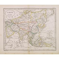
Carte d'Asie . . .
Map of the Asian continent, from Atlas moderne portatif composé de vingt-huit cartes sur toutes les parties du globe terrestre .. A l'usage des Colléges, des Pensions &...
- $230 / ≈ €199
Date: Paris, Prudhomme, Levrault, Debray, 1806
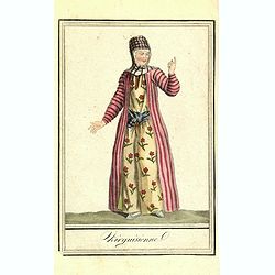
Kirguisienne.
Originally hand-colored mezzotint from 'Costumes civils actuels de tous les peuples connus', showing a native of Kyrgyzstan, a Central Asian country along the Silk Road, ...
- $25 / ≈ €22
Date: Paris,1801-1806
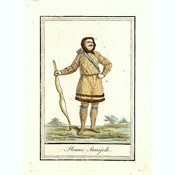
Homme Samojede.
Originally hand-colored mezzotint costume plate of a man from Samojede engraved by Félix Mixelle and Lachaussée Jeune after Jacques Grasset de Saint-Sauveur.As an etche...
Date: Paris,1801-1806
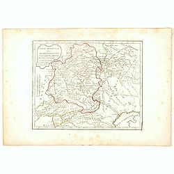
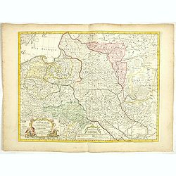
Partie Méridionale de la Russie Européenne, Tartarie Russienne, Petite Tartarie.
Map of the southern part of Russia and Tartary. The Caspian Sea in lower right corner. By C. F. Delamarche, successor of Robert de Vaugondy, Geographer.
- $90 / ≈ €78
Date: Paris, 1806
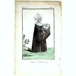
Femme d'Ausbourg.
Originally hand-colored mezzotint from 'Costumes civils actuels de tous les peuples connus'. After Jacques Grasset de Saint-Sauveur. As an etcher, drawer and writer, Gras...
- $50 / ≈ €43
Date: Paris,1806
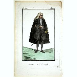
Homme d'Ausbourg.
Originally hand-colored mezzotint from 'Costumes civils actuels de tous les peuples connus'. After Jacques Grasset de Saint-Sauveur. As an etcher, drawer and writer, Gras...
- $50 / ≈ €43
Date: Paris,1806
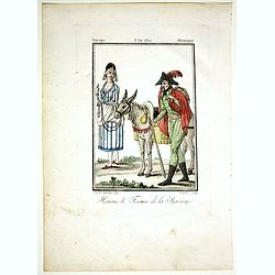
Homme & Femme de la Baviere.
Originally hand-colored mezzotint from 'Costumes civils actuels de tous les peuples connus'. Engraved by Félix Mixelle after Jacques Grasset de Saint-Sauveur.As an etche...
- $50 / ≈ €43
Date: Paris,1806
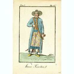
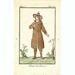
Homme Kouritien.
Originally hand-colored mezzotint of Siberian man dressed in native garb engraved by Félix Mixelle and Lachaussée Jeune after Jacques Grasset de Saint-Sauveur.As an etc...
- $25 / ≈ €22
Date: Paris,1801-1806
Homme Tschoukotske.
Originally hand-colored mezzotint of a man from Tschukotka, Syberia engraved by Félix Mixelle and Lachaussée Jeune after Jacques Grasset de Saint-Sauveur.As an etcher, ...
- $25 / ≈ €22
Date: Paris,1801-1806
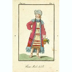
Femme Kamls chadalle.
Originally hand-colored mezzotint of native woman from Kams, Siberia, Russland engraved by Félix Mixelle and Lachaussée Jeune after Jacques Grasset de Saint-Sauveur.As ...
- $50 / ≈ €43
Date: Paris,1801-1806
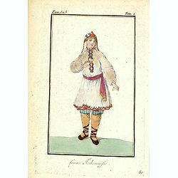
Femme Tschermifse.
Originally hand-colored mezzotint from 'Costumes civils actuels de tous les peuples connus'. Originally hand-colored mezzotint of Native Americans engraved by Félix Mixe...
- $50 / ≈ €43
Date: Paris,1801-1806
Femme Touralinze.
Originally hand-colored mezzotint from 'Costumes civils actuels de tous les peuples connus'. Originally hand-colored mezzotint of Native Americans engraved by Félix Mixe...
- $50 / ≈ €43
Date: Paris,1801-1806
La Pologne Dressée sur ce qu'en ont donné Starovolsk, Beauplan, Hartnoch. . .
This is a late edition of the De L'Isle copper plate with a date of 1806. The copper plate was used many times and has several erased addresses. This one with address &qu...
- $750 / ≈ €649
Date: Paris, 1806
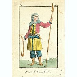
Femme Kourilienne.
Originally hand-colored mezzotint of a native Kourilles lady engraved by Félix Mixelle and Lachaussée Jeune after Jacques Grasset de Saint-Sauveur. From 'Costumes civil...
- $25 / ≈ €22
Date: Paris,1801-1806
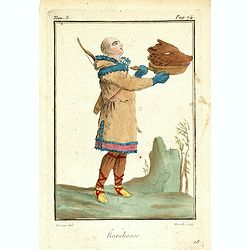
Karakasse.
Originally hand-colored mezzotint of a native Tartary man holding a bear's head engraved by Félix Mixelle and Lachaussée Jeune after Jacques Grasset de Saint-Sauveur. F...
- $25 / ≈ €22
Date: Paris,1801-1806
Femme Kirguisses.
Originally hand-colored mezzotint of Native Tartary lady engraved by Félix Mixelle and Lachaussée Jeune after Jacques Grasset de Saint-Sauveur. From 'Costumes civils ac...
- $25 / ≈ €22
Date: Paris,1801-1806
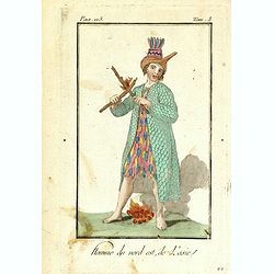
Homme du nord est de l'Asie.
Originally hand-colored mezzotint of a native from North Eastern Russia engraved by Félix Mixelle and Lachaussée Jeune after Jacques Grasset de Saint-Sauveur. From 'Cos...
- $50 / ≈ €43
Date: Paris,1801-1806
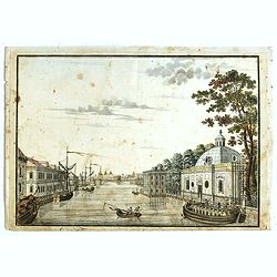
(Die Fontanka beim kaiserlichen Garten in Petersbourg.)
Fontanka River at the Summer Garden in Saint Petersburg. Part of a set of 14 loose and individually mounted plates of views of St. Petersburg and Moscow, plus one plate o...
- $100 / ≈ €87
Date: St. Peterdburg, 1806
![Fille Wotÿake [together with] Femme Wotÿake.](/uploads/cache/36934-250x250.jpg)
Fille Wotÿake [together with] Femme Wotÿake.
Set of two originally hand-colored mezzotints of Native Russians engraved by Félix Mixelle and Lachaussée Jeune after Jacques Grasset de Saint-Sauveur.As an etcher, dra...
- $35 / ≈ €30
Date: Paris,1801-1806
![[Title page] Atlas Universel. . .](/uploads/cache/48053-250x250.jpg)
[Title page] Atlas Universel. . .
Beautiful title-frontispiece from the famous universal atlas initiated by geographers Gilles Robert and his son Didier Robert de Vaugondy, revised, corrected and enhanced...
Date: Paris, 1806
Jacout.
Originally hand-colored mezzotint from 'Costumes civils actuels de tous les peuples connus'. Originally hand-colored mezzotint of Native Americans engraved by Félix Mix...
- $50 / ≈ €43
Date: Paris,1801-1806
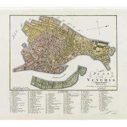
Plan von Venedig.
An uncommon and finely rendered town-plan of Venice. The work is highly detailed and provides a 133-point legend identifying the town's key sites and places of import. L...
Date: Weimar, 1807
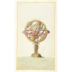
Sphere (No title)
Rare Italian print of a sphere. Paper size 350x225mm. From his "Atlante della geografia antica e moderna".
- $120 / ≈ €104
Date: Milan, 1807
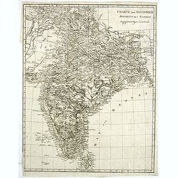
Charte von Ostindien disseits des Ganges im gegenwärtigen Zustande.
A uncommon issue of this detailed map of India, including Ceylon.
Date: Weimar, 1807
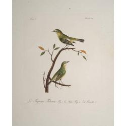
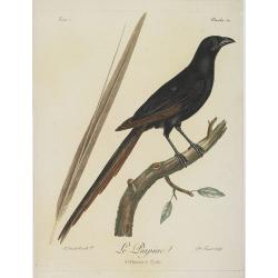
Le Figuier Tcheric.
Very decorative plate from Histoire naturelle des oiseaux d'Afrique , published by Delachaussée. Levaillant's interest in natural history led him to explore Africa as th...
- $180 / ≈ €156
Date: Paris 1796-1808
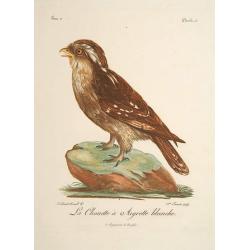
La Chouette a Aigrette Blanche.
Very decorative plate from Histoire naturelle des oiseaux d'Afrique , published by Delachaussée. Levaillant's interest in natural history led him to explore Africa as th...
- $120 / ≈ €104
Date: Paris, 1796-1808
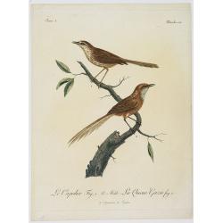
Le Capolier. Fig. 1 Le Mâle. La Queue Gazée Fif. 2. Planche 130.
Very decorative plate from Histoire naturelle des oiseaux d'Afrique , published by Delachaussée. Levaillant's interest in natural history led him to explore Africa as th...
Date: Paris, 1796-1808
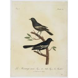
La Mésange noir. Fig.1 Le Mâle. Fig.2. La Femelle. Planche 137.
Very decorative plate from Histoire naturelle des oiseaux d'Afrique , published by Delachaussée. Levaillant's interest in natural history led him to explore Africa as th...
Date: Paris, 1796-1808
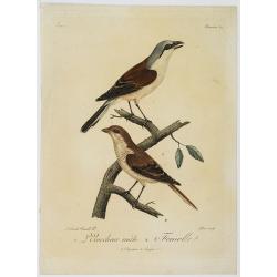
1. L'Ecorcheur mâle. 2. Femelle. Planche 64.
Very decorative plate from Histoire naturelle des oiseaux d'Afrique , published by Delachaussée. Levaillant's interest in natural history led him to explore Africa as th...
Date: Paris, 1796-1808
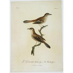
Le Grivetin mâle fig. 1. La Femelle fig. 2. Planche 118.
Very decorative plate from Histoire naturelle des oiseaux d'Afrique , published by Delachaussée. Levaillant's interest in natural history led him to explore Africa as ...
Date: Paris, 1796-1808
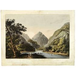
(RESERVED) A view in Oheitepeha Bay in the Island of Otaheite. (Tahiti)
A view of Vaitepiha Bay (Tahiti), with a mountainous landscape, with a river in the centre, a small canoe, Tahitian houses to the right, and a Tahitian couple in the left...
Date: London, Boydell and Co., 1808
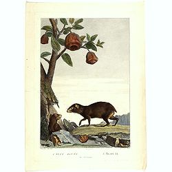
Cavia Aguti - L'Agouti - Tiers de la grandeur. (Cavia)
Fine illustration of two cavia's, from the book "Illustrations de La Ménagerie du Muséum National d'Histoire Naturelle" or "The Menagerie of the National...
- $75 / ≈ €65
Date: Paris, 1808
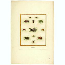
Hannetons. (Beetels)
Fine illustration of 12 beetles, from the book "Illustrations de La Ménagerie du Muséum National d'Histoire Naturelle" or "The Menagerie of the National ...
- $75 / ≈ €65
Date: Paris, 1808
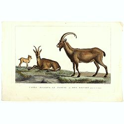
Capra Aegagrus, Le Paseng ou Bouc sauvage, Septieme de la Grandeur. (Wild goat)
Fine illustration of a Wild goats, from the book "Illustrations de La Ménagerie du Muséum National d'Histoire Naturelle" or "The Menagerie of the Nationa...
- $50 / ≈ €43
Date: Paris, 1808
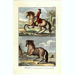
Manège, La Galop uni à gauche et le faux à gauche. (PL IV)
Copperplate engraving of horses by Robert Bénard (1734, Paris – 1777) taken from Encyclopédie de Diderot et d'Alembert.
- $60 / ≈ €52
Date: Paris, 1808
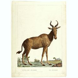
Antilope Bubalis - Le Bubale - Sisieme de la grandeur. (Antilope)
Fine illustration of an Antilope, from the book "Illustrations de La Ménagerie du Muséum National d'Histoire Naturelle" or "The Menagerie of the National...
- $75 / ≈ €65
Date: Paris, 1808
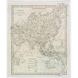
Asia, drawn from the latest Astronomical Observations.
This finely engraved, and detailed, map of Asia shows the extent of knowledge from astronomical observations at the time. It is also of interest for showing Australia her...
- $100 / ≈ €87
Date: London ca. 1808
Le Piacpiac. Planche 54. Tome 2.
This is a very decorative plate from Histoire naturelle des Oiseaux d'Afrique, published by Delachaussée. Levaillant's interest in natural history led him to explore Af...
Date: Paris, 1796-1808
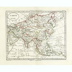
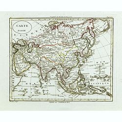
Carte d'Asie.
Fine map of Asia, with an interesting representations of Japan, Hokkaido, Sakhalin Island, Kamchatka and Korea. Engraved by Alexandre Blondeau, who also worked for Depot ...
- $150 / ≈ €130
Date: Paris, c. 1810
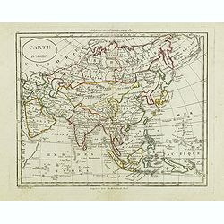
Carte d'Asie.
Fine map of Asia, with an interesting representations of Japan, Hokkaido, Sakhalin Island, Kamchatka and Korea. Engraved by Alexandre Blondeau, who also worked for Depôt...
Date: Paris, c. 1810
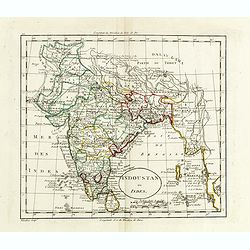
Indoustan ou Inde.
Map of India. The map is based on the Paris Meridian, only in 1884, at the International Meridian Conference in Washington DC, the Greenwich Meridian was accepted.Engrave...
- $100 / ≈ €87
Date: Paris, c. 1810
Carte d'Asie.
Fine map of Asia, with an interesting representation of Japan, Hokkaido, Sakhalin Island, Kamchatka, and Korea. Engraved by Alexandre Blondeau, who also worked for Depôt...
- $175 / ≈ €151
Date: Paris, c. 1810
Carte d'Asie.
Fine map of Asia, with an interesting representations of Japan, Hokkaido, Sakhalin Island, Kamchatka and Korea. Engraved by Alexandre Blondeau, who also worked for Depôt...
- $150 / ≈ €130
Date: Paris, c. 1810
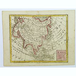
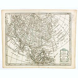
L'Asia...
A small, uncomplicated map of Asia with outline coloring. Map extends down from the Arctic Circle to Java and New Guinea. From Arabia in the west to Japan in the east.Sma...
- $175 / ≈ €151
Date: Venezia, 1810