Browse Listings
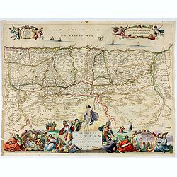
![[Map of the Holy Land, Israel, and Palestine.]](/uploads/cache/43037-250x250.jpg)
[Map of the Holy Land, Israel, and Palestine.]
A fine example of the six sheet map by Georgius Hornius map of the Holy Land. Each of the maps is embellished with countless vignettes and other images drawn from Biblica...
Date: Amsterdam, Janssonius, 1662
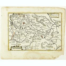
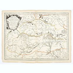
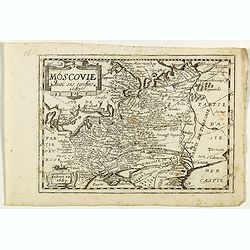
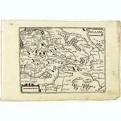
Moscovie. (34).
Scarce map of Muscovy and part of Poland and Lithuania published by Antoine de Fer in 1661 or 1662 in "Cartes de géographie revues et augmentées". The series ...
- $150 / ≈ €130
Date: Paris, Antoine de Fer, 1657 but 1661 or 1662
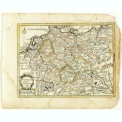
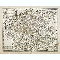
Nouvelle Carte d'Allemagne 1651. (29).
Scarce map of Germany, Poland and the Low Countries, published by Antoine de Fer in 1661 or 1662 in "Cartes de géographie revues et augmentées". With number 2...
- $50 / ≈ €43
Date: Paris, Antoine de Fer, 1657 but 1661 or 1662
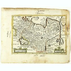
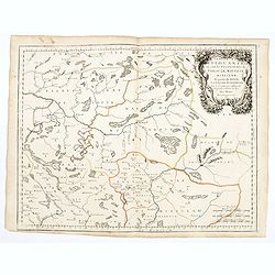
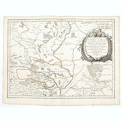
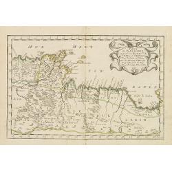
Tartarie. (20).
Scarce map of Tartary published by Antoine de Fer in 1661 or 1662 in "Cartes de géographie revues et augmentées". With number 20 in lower right bottom of the ...
- $100 / ≈ €87
Date: Paris, Antoine de Fer, 1657 but 1661 or 1662
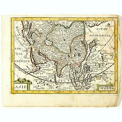
Asie. (8).
Scarce map of Asia published by Antoine de Fer in 1661 or 1662 in "Cartes de géographie revues et augmentées". With number 8 in lower right bottom of the map....
- $200 / ≈ €173
Date: Paris, Antoine de Fer, 1657 but 1661 or 1662
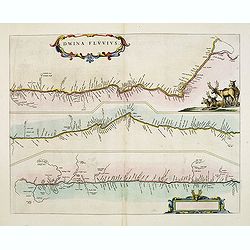
Dwina Fluvius.
An interesting strip-style map showing the course of the Dvina River in three sections from the Black Sea into the White Sea at Archangel. A group of reindeer and two str...
- $500 / ≈ €433
Date: Amsterdam, 1662
Benevole Lector, in hac tabulâ Urbis Moskuae . . .
Rare from his atlas Major. An extremely fine plan of Moscow, which is likely to have been based upon the survey ordered by Boris Fyodorovich Godunov. With a 60-point key,...
- $2750 / ≈ €2380
Date: Amsterdam, 1662
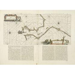
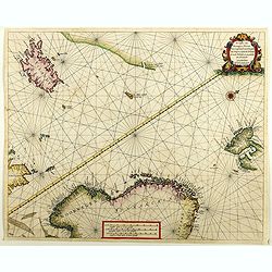
Fretum Nassovium vulgo de Straet Nassou.
Decorative map of the Nassau Strait, from the Atlas Major. Includes 2 compass roses, sailing ships, rhumb lines and 2 elaborate cartouches. Latin text below and on verso....
Date: Amsterdam, 1662
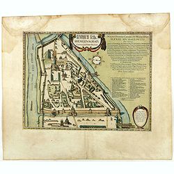
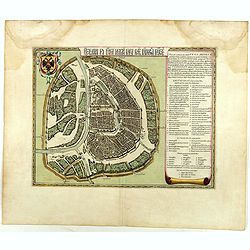
Kremlenagrad, Castellum urbis Moskvae . . .
Rare plan of the Kremlin, which appeared only in his Atlas Major. The map shows exceptional detail inside the heart of Moscow's inner walled fortress and the Kitai Gorod ...
- $2750 / ≈ €2380
Date: Amsterdam, 1662

Mappa Aestivarum Insularum alias Barmudas.
Blaeu based his work on John Speed's remarkably accurate map of 1626-1627. It shows the island divided into tribes and lots, and below the map itself appear the names of ...
Date: Amsterdam, 1662
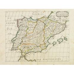
![L'Espagne subdivisée en tous ses royaumes, princip[au]tés, seign[eu]ries. . .](/uploads/cache/33236-250x250.jpg)
L'Espagne subdivisée en tous ses royaumes, princip[au]tés, seign[eu]ries. . .
Map of Spain, Portugal, Majorca and Minorca with original outline hand-color. Numerous place-names of counties, cities, towns, physical features.
- $400 / ≈ €346
Date: Paris, 1663
Le Païs de Canaan traversé par notre seigneur Iesus Christ et les apostres.
Fine map of Israel with north oriented to right. Large decorative title cartouche at bottom surrounded by vignettes depicting the life of Christ. At top, putti hold banne...
- $450 / ≈ €389
Date: Amsterdam, 1663
![Noweav Mexiqve [California as an Island]](/uploads/cache/03796-250x250.jpg)
Noweav Mexiqve [California as an Island]
Uncommon miniature map of California as a island, from Pierre Duval's La Geographie Universeille in a second state. The map is derived from Audience de Guadalajara (1657)...
Date: Paris, 1663
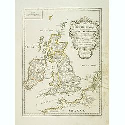
Carte des Isles Britanniques où sont les Royaumes d'Angleterre et d'Ecosse que nous appellons Grande Bretagne et celui d'Irlande avec les isles qui en sont proche . . .
General map of the British isles, with a fine title cartouche upper right with the date 1663 and the complete title reads : "Carte des Îles britanniques où se trou...
- $250 / ≈ €216
Date: Paris, 1663
La Livonie duché divisée en ses princip. parties Esten & Letten & c. / par le Sr. Sanson. . .
Fine map of the Baltic Coast from Riga to the Gulf of Finland, with the islands of Saaramaa and Hiiumaa off the coast of Estonia. Title cartouche in lower left corner and...
Date: Paris, 1663
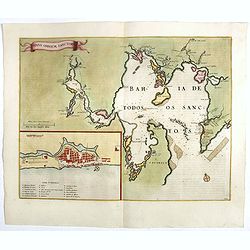
Sinus Omnium Sanctoru. Bahia de Todos os Sanctos.
RARE. First Atlas Major issue: originally issued by Blaeu in Casper van Baarle's 'Rerum per Octennium in Brasilia' (1647) dedicated to the former Governor of the Dutch co...
Date: Amsterdam, 1664
Empire d'Allemagne, divisé en ses dix Cercles ... Royaume de Boheme...
Covering Germany, Low Countries, Poland, Switzerland, Austria and Czech Republic. Nicolas Sanson was to bring about the rise of French cartography, although the fierce co...
- $250 / ≈ €216
Date: Paris, 1665
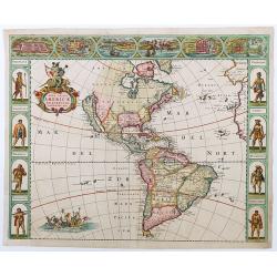
Nova Totius Americae descriptio.
First state of de Wit's first map of America, with figured borders on three sides. North America has a good overall outline, with a completed Hudson Bay and Baffin Island...
Date: Amsterdam, 1665
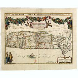
Situs Terrae Promissionis.
Superb map with north oriented to the left. It is finely engraved with numerous biblical scenes including the Exodus, the wandering of the Children of Israel, and several...
- $700 / ≈ €606
Date: Amsterdam, 1665
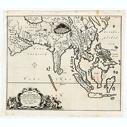
Tabula Geographica Hydrophylacium Asiae Majoris exhibens, quo Omnia Flumina sive proxime sive remote per occultos maeandros Originem suam Sortiuntur.
Rare and Interesting map showing Asia from Arabia in the west until China, Japan, Korea and Philippines with Indonesia. From Kircher's "Mundus Subterranaeus". ...
- $300 / ≈ €260
Date: Amsterdam, 1665

Pas-Caart van de ZUYDER-ZEE, Texel ende Vlie-stroom.als mede 't Amelander gat (Hollandt/Vrieslandt)
An attractive chart of the Zuiderzee, now the inland water het IJselmeer.HOLLANDT / VRIESLANDTPas-Caart van de Zuyder-Zee, Texel ende Vlie-stroom.als mede 't Amelander g...
- $1000 / ≈ €865
Date: Amsterdam, c. 1665
Partie de Lithuanie ou est en partie le Palatinat de Nowogrodeck Litawiski, subdivisé en leurs Chastellenies , le Palatinat de Bressici en Polesie, avec les duchés de Neswies, et Slusck, et partie du Palatinat de Minsk.
Scarce regional map, centered on Pinsk and showing Polish Lithuania, including part of modern Poland, Belarus, etc. This edition carries the date 1665. Nicolas Sanson was...
Date: Paris, 1665
Partie de Lithuanie où sont les palatinats de Poloczk, Witepsk, Mseislaw, et partie de Minsk avec le duché de Smolensko.
Scarce and fine map of Belarus, including Smolensko in Russia and the region northeast of Minsk. This edition carries the date 1665 and the publishers address "A Par...
Date: Paris, 1665

.Pascaerte Vande Zuyd-Zee tusschen California, en Ilhas de Ladrones. . .
A decorative and most interesting map - being one of the earliest of the Pacific to record the observations of Tasman's voyages. The northern part of the island of Califo...
Date: Amsterdam, 1666

Noordoost Cust van Asia van Japan tot Nova Zemla.
An eye-catching chart of Japan, Hokkaido and the Islands to the North of Japan. In the lower left Korea and part of northern China. Korea has three names mentioned: "...
- $2000 / ≈ €1731
Date: Amsterdam, 1666
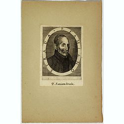
P. Famiano Strada.
Portrait of Famiano Strada, published in "Elogii D' Hvomini Letterati Scritti", by Lorenzo Crasso. Famiano Strada (1572–1649) was a Jesuit writer, who was bor...
- $120 / ≈ €104
Date: Venice, 1666

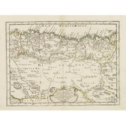
De Cust van Barbaryen van out Mamora tot Capo Blanco..
Six charts on one sheet. The two upper charts covering an area from Cape Blanc to Casablanca. In lower part four insets with detailed charts of islands as Madera, Porto S...
Date: Amsterdam, 1666

De Cust van Barbaria, Gualata, Arguyn, en Gene..heo, van Capo S.Vincente tot Capo Verde.
An eye-catching chart of the north western coast of Africa. Including Canary Islands, Cape Verde Islands and Azores.Pieter Goos (ca. 1616-1675) was one of the most import...
Date: Amsterdam, 1666

Pas-Caart van Guinea en den Custen daer aen gelegen Van C..
A decorative chart of the southwest coast of Africa, embellished with an elaborate, finely colored title-cartouche, and 2 compass-roses. Pieter Goos (ca. 1616-1675) was o...
Date: Amsterdam, 1666
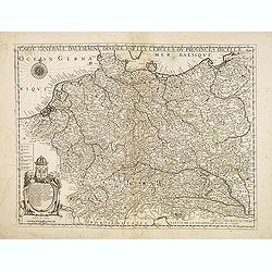
Carte générale d'Alemagne divisée par les cercles ou provinces d'icelle.
Rare and detailed map of Germany, Poland and Austria, engraved by H. le Roy in 1643 or 1666 for Jacques L'Agniet. The publishing house Jollain bought the copper plate and...
Date: Paris, 1666
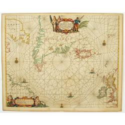
De custen van Noorwegen, Finmarcken, Laplandt, Spitsbergen . . .
Detailed sea chart of Norway, Finland, Iceland, Spitsbegen and part of Scotland published by Hendrik Donker. The Greenwich meridian is in the middle of the chart. The ch...
Date: Amsterdam, 1666
Pascaerte van Groen-Landt, Yslandt, Straet Davids en Ian Mayen eylandt. . .
An eye-catching chart of the North Atlantic, showing prominent Greenland, Iceland, and parts of the North American continent. The map is decorated with a large figurative...
- $1000 / ≈ €865
Date: Amsterdam, 1666

.Caarte voor een gedeelte der Canarise Eylanden als Canaria, Tenerifa, Forteventura, etc.
Very rare chart of the Canaries. Showing Palma, Ferro, Tenerife, Gran Canaria, Forteventura, Lancerota. In upper right hand corner inset of harbour of Lancerota.
- $1000 / ≈ €865
Date: Amsterdam, 1666
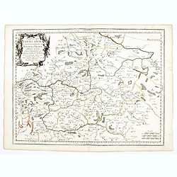
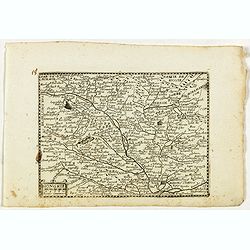
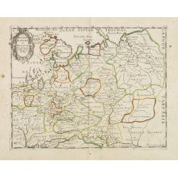
Partie de Lithuanie ou sont en partie les Palatinats de Wilna, et Troki, subdivisés en leurs Chastellenies et partie du Palatinat de Minsk.
Fine map of Lithuania. This edition carries the date 1665 and the publishers address "A Paris, chez Pierre Mariette, rue Saint Jacques a l'Esperance…"Nicolas ...
Date: Paris, 1666
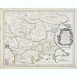
Illyricum Orientis In quo Partes II. Moesia et Thracia. Provinciae XI.
Attractive historical map of the area west of the Black Sea, today's Bulgaria, Rumania, etc. Based on the cartography of Nicolas Sanson and published by P.Mariette. With ...
- $400 / ≈ €346
Date: Paris, 1666
Partie de Lithuanie ou sont en partie les Palatinats de Minsk, et Mseislaw, we les Seign.Ries ou Terres de Rohaczow, Rzeczica, Zernobee, et partie des. . .
Fine map of Lithuania. This edition carries the publishers address "chez l'Autheur Avec privilege pour vingt ans 1666". Nicolas Sanson was to bring about the ri...
Date: Paris, 1666
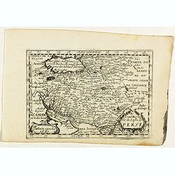
Le grand Royaume du Sophi de Perse.
Rare map of Persia with present-day Iran and Iraq published by Jollain in 1667. Published in "Trésor Des Cartes Geographiques Des Principaux Estats de Lunivers"...
- $250 / ≈ €216
Date: Paris, 1667
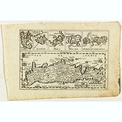
Candie.
Rare map of Crete with in top six small inset maps of Greek islands, published by Jollain in 1667. Published in "Trésor Des Cartes Geographiques Des Principaux Esta...
- $350 / ≈ €303
Date: Paris, 1667
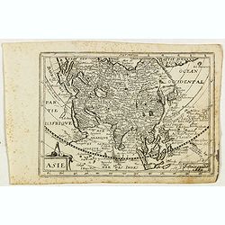
Asie.
Rare map of Asia, published by Jollain in 1667. The name of Korea placed in the sea in between Korea and Japan. In top right part of North America. Published in "Tr�...
- $400 / ≈ €346
Date: Paris, 1667
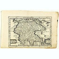
Moree jadis Peloponese.
Rare map of Peloponnese, published by Jollain in 1667. Published in "Trésor Des Cartes Geographiques Des Principaux Estats de Lunivers".This atlas is based upo...
- $300 / ≈ €260
Date: Paris, 1667
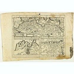
Royaume de Fez. . .
Map of Morocco prepared by N.Sanson and published by Pierre Mariette.Published in an early edition of the small Sanson atlas L'Europe Dediée a Monseigneur . . . Le Telli...
- $120 / ≈ €104
Date: Paris, P. Mariette, 1667
Moscovie avec ses confins.
Rare map of Russia, published by Jollain in 1667. Published in "Trésor Des Cartes Geographiques Des Principaux Estats de Lunivers".This atlas is based upon Boi...
- $450 / ≈ €389
Date: Paris, 1667
Hongrie.
Rare map of Hungary, published by Jollain in 1667. Published in "Trésor Des Cartes Geographiques Des Principaux Estats de Lunivers".This atlas is based upon Bo...
- $300 / ≈ €260
Date: Paris, 1667
Russie.
Rare map of Russia, published by Jollain in 1667. Published in "Trésor Des Cartes Geographiques Des Principaux Estats de Lunivers".This atlas is based upon Boi...
- $250 / ≈ €216
Date: Paris, 1667
Partie de la Barbarie ou est le royaume d'Alger. . .
Coastal map of North Africa prepared by N.Sanson and published by Pierre Mariette.Published in an early edition of the small Sanson atlas L'Europe Dediée a Monseigneur ....
- $80 / ≈ €69
Date: Paris, P. Mariette, 1667
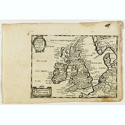
Angleterre Ecosse et Hibernie.
Rare map of the British islands, published by Jollain in 1667. Published in "Trésor Des Cartes Geographiques Des Principaux Estats de Lunivers".This atlas is b...
- $250 / ≈ €216
Date: Paris, 1667
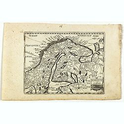
Norvege et Suede.
Rare map of Norway, Sweden and Finmark published by Jollain in 1667. Published in "Trésor Des Cartes Geographiques Des Principaux Estats de Lunivers".This atla...
- $250 / ≈ €216
Date: Paris, 1667
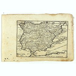
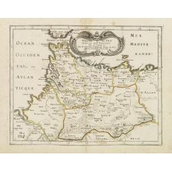
Espagne.
Rare map of Spain and Portugal, published by Jollain in 1667. Published in "Trésor Des Cartes Geographiques Des Principaux Estats de Lunivers".This atlas is ba...
- $200 / ≈ €173
Date: Paris, 1667
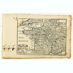
France nouvellement descripte.
Rare map of France, published by Jollain in 1667. Published in "Trésor Des Cartes Geographiques Des Principaux Estats de Lunivers".This atlas is based upon Boi...
- $150 / ≈ €130
Date: Paris, 1667
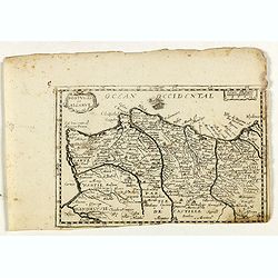
Portugal et Algarve.
Rare map of Portugal, published by Jollain in 1667. Published in "Trésor Des Cartes Geographiques Des Principaux Estats de Lunivers".This atlas is based upon B...
- $150 / ≈ €130
Date: Paris, 1667
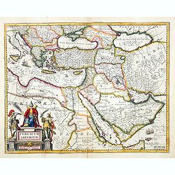
Turcicum Imperium. Concordia res parvæ crescunt discordia maximæ dilabuntur.
An impressive and attractive map with a particularly fine cartouche showing the Turkish Sultan on his throne and allegorical figures at either side brandishing weapons.Sa...
- $1100 / ≈ €952
Date: Amsterdam, 1667
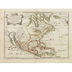
Americque Septentrionale. . .
A general map of North America shows California as an island, but with few names and a flat northern coastline. Prepared by N. Sanson and engraved by A.Peyrounin. A firs...
- $1000 / ≈ €865
Date: Paris, P. Marriete, 1667
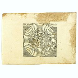
Le monde et sa disposition suivant Ptolomée.
The Christian Aristotelian cosmos. Ptolemy accepted the following order for celestial objects in the solar system: Earth (center), Moon, Mercury, Venus, Sun, Mars, Jupite...
- $150 / ≈ €130
Date: Paris, 1667
![[Title page] Tables de la Géographie ancienne et nouvelle… De toutes les parties du monde …](/uploads/cache/47927-250x250.jpg)
[Title page] Tables de la Géographie ancienne et nouvelle… De toutes les parties du monde …
Title page of "Tables de la Géographie ancienne et nouvelle… De toutes les parties du monde..."Read more about decorative atlas title pages [+]
- $350 / ≈ €303
Date: Paris, 1667
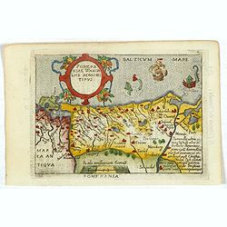
Pomeraniae Wandalice Regionis Tipus.
Miniature map of Pomerania embellished by rich cartouche, vessel and sea monsters in the Baltic. Abraham Ortelius (1527-1598) was a cartographer and publisher, who is bor...
- $250 / ≈ €216
Date: Antwerp, 1667
![[Title page for ] Nuevo Atlas o Teatro De todo el Mundo . . . Otra parte del Tomo Primero.](/uploads/cache/47925-250x250.jpg)
[Title page for ] Nuevo Atlas o Teatro De todo el Mundo . . . Otra parte del Tomo Primero.
Title page to the Spanish text edition : Nuevo Atlas o Teatro De todo el Mundo . . . Otra parte del Tomo Primero.Read more about decorative atlas title pages [+]
- $300 / ≈ €260
Date: Amsterdam, 1667
Russie Blanche ou Moscovie.
Map of the European part of Russia prepared by N.Sanson and published by Pierre Mariette.Published in an early edition of the small Sanson atlas L'Europe Dediée a Monsei...
Date: Paris, P. Mariette, 1667
Espagne. . .
Map of Spain and Portugal prepared by N.Sanson and published by Pierre Mariette.Published in an early edition of the small Sanson atlas L'Europe Dediée a Monseigneur . ....
Date: Paris, P. Mariette, 1667
Nouvelle description de lamerique.
Jollain published this rare map of America in 1667. State 3, with the scale, erased, as it fictitious strait on the west coast of North America which Le Royaume de Quiuer...
- $450 / ≈ €389
Date: Paris, 1667
Mer Noire ou Mer Maievre, . . .
Map of the Black Sea prepared by N.Sanson and published by Pierre Mariette.Published in an early edition of the small Sanson atlas L'Europe Dediée a Monseigneur . . . Le...
Date: Paris, P. Mariette, 1667
Le Royaume de Fez.
Rare map of Morocco published by Jollain in 1667. Published in "Trésor Des Cartes Geographiques Des Principaux Estats de Lunivers".This atlas is based upon Boi...
- $150 / ≈ €130
Date: Paris, 1667
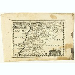
Le Royaume de Marroc.
Rare map of Morocco published by Jollain in 1667. Published in "Trésor Des Cartes Geographiques Des Principaux Estats de Lunivers".This atlas is based upon Boi...
- $100 / ≈ €87
Date: Paris, 1667
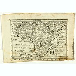
Nouvelle description d'Afrique.
Rare map of Africa published by Jollain in 1667. Published in "Trésor Des Cartes Geographiques Des Principaux Estats de Lunivers".This atlas is based upon Bois...
- $250 / ≈ €216
Date: Paris, 1667
Barbarie.
Rare map of the Barbary Coast of Africa published by Jollain in 1667. Published in "Trésor Des Cartes Geographiques Des Principaux Estats de Lunivers".This atl...
- $100 / ≈ €87
Date: Paris, 1667
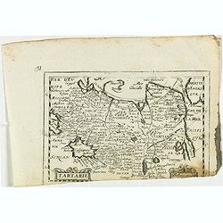
Tartarie.
Rare map of Tartary published by Jollain in 1667. In lower right corner Korea as a peninsular and part of America in upper right corner. Published in "Trésor Des Ca...
- $150 / ≈ €130
Date: Paris, 1667

La Chine.
Rare map of China, Korea (as an island) and Japan, published by Jollain in 1667. In upper right corner part of North America. Published in "Trésor Des Cartes Geogra...
- $350 / ≈ €303
Date: Paris, 1667
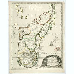
Isle D'Auphine, communement Nommée pae les Europeens Madagascar. . .
One of the most UpToDate maps of Madagascar, also showing the Comoros Islands in the North West and the Reunion Island in the South East.With decorative title cartouche r...
- $900 / ≈ €779
Date: Paris, 1667
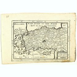
Natolie ou Asie mineur, Lieües d'Alemag.
Rare map of Turkey and Cyprus published by Jollain in 1667. Published in "Trésor Des Cartes Geographiques Des Principaux Estats de Lunivers".This atlas is base...
- $250 / ≈ €216
Date: Paris, 1667
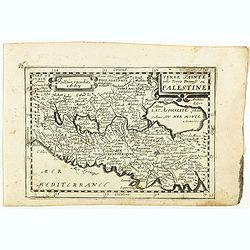
Terre Sainte jadis Terre Promise ou Palestine.
Rare map of the Holy Land published by Jollain in 1667. Published in "Trésor Des Cartes Geographiques Des Principaux Estats de Lunivers".This atlas is based up...
- $300 / ≈ €260
Date: Paris, 1667
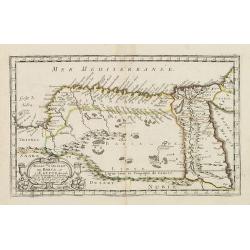
Royaume et desert de Barca, et Aegypte divisee. . .
Map of Egypt prepared by N.Sanson and published by Pierre Mariette.Published in an early edition of the small Sanson atlas L'Europe Dediée a Monseigneur . . . Le Tellier...
- $100 / ≈ €87
Date: Paris, P. Mariette, 1667
Partie de la Barbarie ou sont les royaumes de Tunis et Tripoli. . .
Coastal map of Tunisia and Libya prepared by N.Sanson and published by Pierre Mariette.Published in an early edition of the small Sanson atlas L'Europe Dediée a Monseign...
- $750 / ≈ €649
Date: Paris, P. Mariette, 1667
(Title page) Plans et Profils des principales Villes des Duchez de Loraine et de Bar. . .
Decorative title page by Ch. De Beaulieu.
- $80 / ≈ €69
Date: Paris, 1668
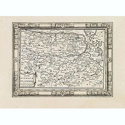
Carte du Comté de Flandre. . .
Decorative map of Flanders from Plans, et Profils des principales villes.. by Ch. De Beaulieu. Etched by mr. Romeijn de Hooghe.
- $80 / ≈ €69
Date: Paris, 1668
![[Title page] Les Plans et Profils des principales Villes et lieux considérables Du Duché de Gueldre. . .](/uploads/cache/33213-250x250.jpg)
[Title page] Les Plans et Profils des principales Villes et lieux considérables Du Duché de Gueldre. . .
Decorative title page from Plans, et Profils des principales villes.. by Ch. De Beaulieu. Etched by mr. Romeijn de Hooghe.
Date: Paris, 1668
![[Title page] Les Plans et Profils des principales Villes et lieux considérables du Comté de Flandre. . .](/uploads/cache/33218-250x250.jpg)
[Title page] Les Plans et Profils des principales Villes et lieux considérables du Comté de Flandre. . .
Decorative title page from Plans, et Profils des principales villes.. by Ch. De Beaulieu. Etched by mr. Romeijn de Hooghe.
- $80 / ≈ €69
Date: Paris, 1668
![[Title page] Les Plans et Profils des principales Villes du Comté de Namur. . .](/uploads/cache/33217-250x250.jpg)
[Title page] Les Plans et Profils des principales Villes du Comté de Namur. . .
Decorative title page from Plans, et Profils des principales villes.. by Ch. De Beaulieu. Etched by mr. Romeijn de Hooghe.More about title pages [+]
- $80 / ≈ €69
Date: Paris, 1668
![[Title page] Les Plans et Profils des principales Villes et lieux considérables du Comté de Haynaut. . .](/uploads/cache/33216-250x250.jpg)
[Title page] Les Plans et Profils des principales Villes et lieux considérables du Comté de Haynaut. . .
Decorative title page from Plans, et Profils des principales villes.. by Ch. De Beaulieu. Etched by mr. Romeijn de Hooghe.
- $80 / ≈ €69
Date: Paris, 1668
![[Title page] Les Plans et Profils des principales Villes et lieux considérables Du Duché de Brabant. . .](/uploads/cache/33214-250x250.jpg)
[Title page] Les Plans et Profils des principales Villes et lieux considérables Du Duché de Brabant. . .
Decorative title page from Plans, et Profils des principales villes.. by Ch. De Beaulieu. Etched by mr. Romeijn de Hooghe.
- $80 / ≈ €69
Date: Paris, 1668

Paskaart van Guinea van C.Verde tot R. deGalion.
Rare edition of Doncker's sea chart of Guinea coast. From an atlas printed in 1668, "l'Atlas de MER ou MONDE AQUATIQUE, Remontrant toutes lescôtes de la Mer…"...
- $1000 / ≈ €865
Date: Amsterdam, 1660-1668

Pascaart van de west cust van Engeland en Wales Van S. Davids Point tot de Moul van Dalway.
Rare Doncker's sea chart of the Irish Sea with the west Coast of England (Liverpool), the Island of Man and the western-most tip of Northern Ireland (Bangor) and Souther...
Date: Amsterdam, 1660-1668