Browse Listings
![[Title page] Les Plans et Profils des principales Villes et lieux considérables Du Duché de Gueldre. . .](/uploads/cache/33213-250x250.jpg)
[Title page] Les Plans et Profils des principales Villes et lieux considérables Du Duché de Gueldre. . .
Decorative title page from Plans, et Profils des principales villes.. by Ch. De Beaulieu. Etched by mr. Romeijn de Hooghe.
Date: Paris, 1668
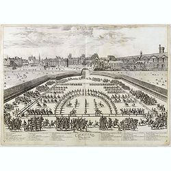
Comparse des Cinq Quadrilles dans l'Amphitheatre.
An early and intriguing engraving recording one of the most celebrated and spectacular festivals held at Paris by the young Louis XIV. The multi-day tournament took place...
Date: Paris, imprimerie royale, 1670
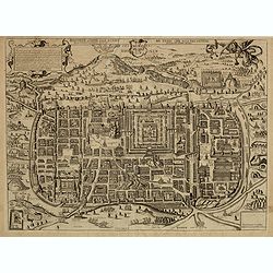
Jerusalem comme elle estoit du temps que nostre Sauveur Jesus-Christ souffrit mort et passion pour nous.
Rare and decorative view imaginary plan of ancient Jerusalem and its suburbs published by Gérard Jollain after Christian van Adrichom (1533-1595) plan.The plan itself is...
Date: Paris, ca.1670
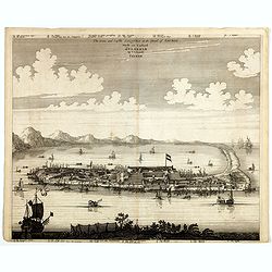
Peking.
Fine panoramic view of Peking. From Olfert Dapper mission to China, 1662-1663. Printed by Jacob van Meurs, title of the book: Gedenckwaerdig bedrijf der Nederlandsche Oos...
- $200 / ≈ €173
Date: Amsterdam, 1670
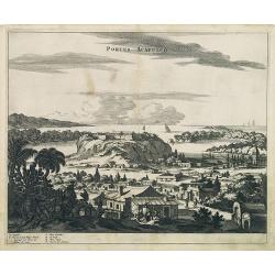
Portus Acapulco.
Attractive view of the city and harbor of Acapulco, showing fortifications, outlying buildings, ships in the harbor, costumed locals, etc.This map is taken from Ogilby's ...
- $300 / ≈ €260
Date: London, 1671
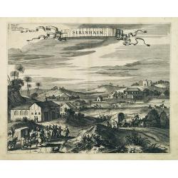
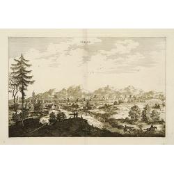
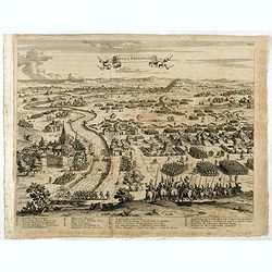
Serinhaim.
Fine view of a fort in Serinhaim, Brazil, with numbered key at the base. A procession of Portuguese or Dutch soldiers advance along the road carrying a litter. To the lef...
Date: London, 1671
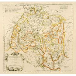
![Nova & exacta Chorographia Latii sive Territorii Romani iuxta veterem et novum situm parallela nomimu[m] comparatione elaborata.](/uploads/cache/44863-250x250.jpg)
Nova & exacta Chorographia Latii sive Territorii Romani iuxta veterem et novum situm parallela nomimu[m] comparatione elaborata.
Map of central Italy, centered on Rome from "Latium" by A. Kircher and designed by Innocenzo Mattei. The title cartouche in the lower right, small legend with 1...
Date: Amsterdam, 1671
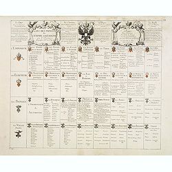
Petites tables Geneologiques touchant les droits et les interests des Princes.
Compilation of Duval's Pocket Atlas, with an archbishoprics and dioceses description of the world, here right at the beginning with the rare genealogical tables of variou...
- $3000 / ≈ €2596
Date: Paris, P. Duval, ca. 1667-1672
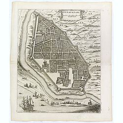
Negapatam.
Bird's-eye view of Nagapattinam or Negapatam, India, printed for the first Dutch edition of Baldaeus' work "A true and exact description of the most celebrated East-...
- $200 / ≈ €173
Date: Amsterdam, 1672
![[Title page from ] Ierusalemsche Reyse.](/uploads/cache/30784-250x250.jpg)
[Title page from ] Ierusalemsche Reyse.
Decorative title page with 2 views of Jerusalem flanked by S. Franciscus and S. Helena. From a very rare travel book by Anthonius Gonsales, "Hierusalemsche Reyse&quo...
- $50 / ≈ €43
Date: Antwerpen, Michiel Cnobbaert, 1673
![[Illustration from Hierusalemsche Reyse.] Interieur of Church of the Holy Sepulchre.](/uploads/cache/30796-250x250.jpg)
[Illustration from Hierusalemsche Reyse.] Interieur of Church of the Holy Sepulchre.
Interior of a Church of the Holy Sepulchre. Below a decorative cartouche with lettered key and surrounded by 2 cherubins.Taken from a very rare travel book by Anthonius G...
- $30 / ≈ €26
Date: Antwerpen, Michiel Cnobbaert, 1673
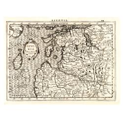
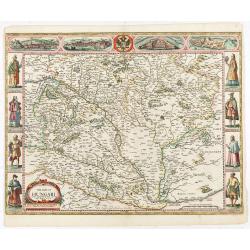
Livonia.
Finely engraved map of the Baltic states Estonia and Latvia filled with forests, rivers and lakes. French text on verso. Engraved by Petrus Kaerius for Janssonius' pocket...
Date: Amsterdam, Jan Cloppenburgh, 1673
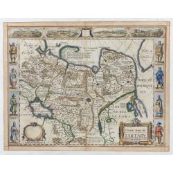
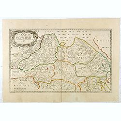
La Souabe.
Fine map of Swabia.This edition carries the date 1674 and the publishers address A PARIS chez l'Autheur aux Galleries du Louvre. Nicolas Sanson was to bring about the ris...
- $75 / ≈ €65
Date: Paris, 1674
![[Lot of 8 maps and prints] Norvegiae Maritimae ab Elf-burgo ad Dronten / Pascaert van Noorwegen streckende van Elf-burg tot Dronten.](/uploads/cache/84130-250x250.jpg)
[Lot of 8 maps and prints] Norvegiae Maritimae ab Elf-burgo ad Dronten / Pascaert van Noorwegen streckende van Elf-burg tot Dronten.
Norvegiae Maritimae ab Elf-burgo ad Dronten / Pascaert van Noorwegen streckende van Elf-burg tot Dronten. Frederick de Wit's fine sea chart of southern Norway. An attr...
- $900 / ≈ €779
Date: Amsterdam, 1675
The citie and Castle Zelandia in the Island of Taywan. / Stadt en casteel Zelandia op 't Eilant Taywan.
This important copperplate engraving is one of the earliest European views of Taiwan, depicting the Dutch fortifications and trading settlements on the island's West coas...
Date: Amsterdam, 1675
Les Estats De L'Empire Du Grand Seigneur Des Turcs En Europe. . .
Prepared by N.Sanson. The map represents the Ottoman Empire based on Sanson's 1654 map. The Arabian Peninsula is shown with much detail, including towns, villages, mounta...
Date: Paris, 1675
The siege of Lagny.
Very rare etching of the siege of Lagny-sur-Marne by the Duc of Parma. Etched by Johann Azelt (1654-1692). A similar print but with the number in the upper right corner i...
- $150 / ≈ €130
Date: Nuremberg, ca 1675
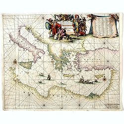
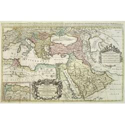
Orientalior districtus Maris Mediterranei.
Beautiful chart of the eastern part of the Mediterranean. Including Italy, the north coast of Africa and part of the Black Sea.The entire sheet is covered with rhumb line...
Date: Amsterdam, 1675
La Ville et le Château de Zélandia dans l' île de Tayovan.
This important copperplate engraving is one of the earliest European views of Taiwan, depicting the Dutch fortifications and trading settlement on the West coast of the i...
- $1800 / ≈ €1558
Date: Amsterdam, 1675

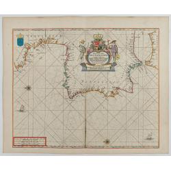
Cimbebas et Caffariae Littora a Catenbela ad Promontorium. . .
The coast of Angola, South-West Africa and South Africa up to Port Elizabeth. Classic sea chart of Dutch school with excellent baroque embellishment. North oriented to th...
Date: Amsterdam, 1675
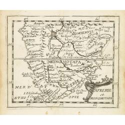
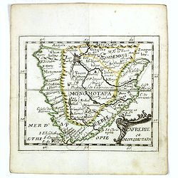
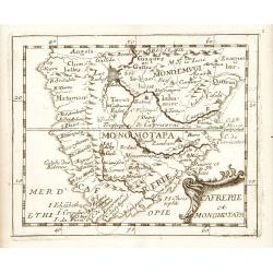
Cafrerie et Monomotapa.
Uncommon miniature map of South Africa from Pierre Duval's "La Geographie Universeille" dated 1676. Following his Cartes de géographie in 1657, Pierre Duval pu...
- $150 / ≈ €130
Date: Paris, 1676

Paskaerte Vande Bocht van Vranckrijk Biscajen en Galissen
An eye-catching chart of Spain and France, including a large part of Brittany, including Isle de Reé , Isle Saint Martin ...Shows the gulf of the northeast Atlantic Ocea...
Date: Amsterdam, 1669-1676
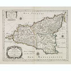
La Sicile, avec les anciens noms de presque toutes ses Places, Rivières, Chateaux &c. et diverses observations nouvelles . . .
Uncommon map of Sicily with fine title cartouche lower right . Original date of 1675 now altered to 1676.More about [+]
Date: Paris, 1676
Cafrerie et Monomotapa.
Uncommon miniature map of South Africa from Pierre Duval's "La Geographie Universeille" dated 1676. Following his Cartes de geographie in 1657, Pierre Duval pub...
- $175 / ≈ €151
Date: Paris, 1676
Introductio in universam geographiam tam veterem, quám novam... et tabulis geographicis aucta studio & operâ Johannis Bunonis. . .
Engraved title with minor ink dash, title with former owner's signatures Joannes Steuchig, (could be the Swedish archbishop Johannes Steuchius (1676-1742). D. Hildebrand ...
- $3000 / ≈ €2596
Date: Amsterdam, 1676
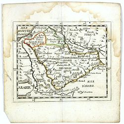
Arabie.
Scarce miniature map of the Arabian peninsular, from Pierre Duval's La Geographie Universeille dated 1676. Following his Cartes de géographie in 1657, Pierre Duval publi...
- $300 / ≈ €260
Date: Paris, 1676
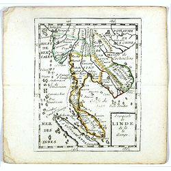
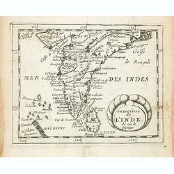
Presqu''isle de LINDE de là le Gange.
Scarce miniature map of Southeast Asia extends from Burma and China in the north to a portion of Sumatra in the south. From Pierre Duval's La Geographie Universeille date...
- $250 / ≈ €216
Date: Paris, 1676
Pas-Caart van Hispangien vertoonde de Custen van Granade…
An eye-catching chart of Spain and Portugal, including a large part of Brittany and the southwestern coast of France, including Isle de Reé , Isle Saint Martin ...Pieter...
Date: Amsterdam, 1669-1676
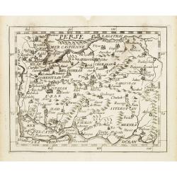
Perse.
Uncommon miniature map of Persia, from Pierre Duval's La Geographie Universeille dated 1676. Following his Cartes de Géographie in 1657, Pierre Duval published this smal...
- $150 / ≈ €130
Date: Paris 1676
Cafrerie et Monomotapa.
Uncommon miniature map of South Africa, from Pierre Duval's "La Geographie Universeille" dated 1676. Following his Cartes de geographie in 1657, Pierre Duval pu...
- $200 / ≈ €173
Date: Paris, 1676
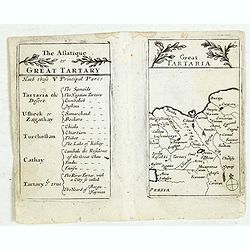
A newe mape of Tartary.
An early edition of one of the most decorative maps of Tartary, known for its figured borders with costume figures, while above are vignettes of the cities of Astrakhan, ...
- $2000 / ≈ €1731
Date: London, 1676
Le jeu des Princes de l'empire d'Allemagne par P. du Val. . .
One of Du Val's magnificent sets of game cards, included in his atlas "Cartes de Geographie".Dated 1674. By the Peace of Westphalia (1648) sovereignty was grant...
- $2000 / ≈ €1731
Date: Paris, 1675-1676
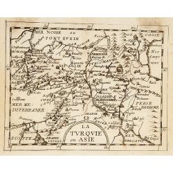
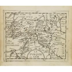
La Turquie en Asie.
Uncommon miniature map of Turkey, Cyprus, Palestine, Iran, and Iraq. From Pierre Duval's "La Geographie Universeille" dated 1676. Following his "Cartes de ...
- $75 / ≈ €65
Date: Paris, 1676

A new mape of Ye XVII Provinces of Low Germanie.
Showing all 17 Provinces of the Netherlands before the split between Spain and the Protestant Provinces under the House of Orange.The map was first published. At the same...
Date: London, 1676
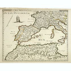
La mer mediterrannée, vers l'Occident. . .
Uncommon map of the western Mediterranean Sea, including France, Spain, Italy, Corsica Sardinia and North Africa. In upper left corner a large sailing vessel.
- $300 / ≈ €260
Date: Paris, 1676
The mape of Hungari newly augmented by John Speede.
A wonderful carte-a-figures map of ‘Hungari’, comprising modern-day Hungary and parts of Slovakia. Showing two sets of four costumed figures on each side of the map a...
Date: Londres, Bassett and Chiswell, 1626 / 1676
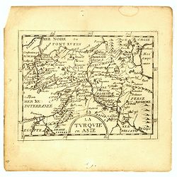
La Turquie en Asie.
Uncommon miniature map of Turkey, Cyprus, Palestine, Armenia, Iran and Iraq. From Pierre Duval's La Geographie Universeille dated 1676. Following his Cartes de geographie...
- $90 / ≈ €78
Date: Paris, 1676
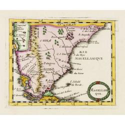
Magellani Que.
Uncommon miniature map of Argentina and Strait of Magellan from Pierre Duval's La Geographie Universeille dated 1676. Following his Cartes de geographie in 1657, Pierre D...
Date: Paris, 1676

Les Isles Terceres. . .
Uncommon map of the Azores. Engraved by Sommer. Du Val is mentioned as the cartographer and the publisher was Pierre Mariette.
Date: Paris, c. 1650 - 1676
La Turquie en Asie.
Uncommon miniature map of Turkey, Cyprus, Palestine, Iran, Iraq. From Pierre Duval's "La Geographie Universeille" dated 1676. Following his "Cartes de geog...
- $100 / ≈ €87
Date: Paris,1676
Presqu''isle de L'Inde de ça le Gange.
Uncommon miniature map of India from Pierre Duval's La Geographie Universeille dated 1676. Following his Cartes de geographie in 1657, Pierre Duval published this smaller...
- $150 / ≈ €130
Date: Paris, 1676
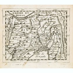
Empire du Mogol.
Uncommon miniature map of the Mongol empire from Pierre Duval's La Geographie Universeille dated 1676. Following his Cartes de geographie in 1657, Pierre Duval published ...
- $150 / ≈ €130
Date: Paris, 1676
Grande Tartarie vers l'orient où sont le Turquestan, la Tartarie septentrionale, et la Tartarie du Kin. . .
Early edition of this rare map of Tartary which incorporates Turkestan (including East Turkestan), Greater Mongolia, Giacathai.The Great Wall is shown in the lower center...
- $750 / ≈ €649
Date: Paris, 1677
![Hardales in Hispanien. [Spain].](/uploads/cache/13750-250x250.jpg)
Hardales in Hispanien. [Spain].
A very nice view of the city Hardales On the foreground, a man hunting a beaver. With a verse in Latin and German underneath the image.The poet and topographer from Comot...
- $60 / ≈ €52
Date: Frankfurt, 1623-1678
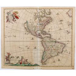
Novissima et Accuratissima Totius Americae descriptio..
Third state of one of the classic Dutch maps of the Americas and one of the most often copied.Lower right hand corner F. de Wit excudit. Longitudinal lines numbered to th...
Date: Amsterdam, [1678
![S. Laurens in Franckr. [France].](/uploads/cache/13810-250x250.jpg)
S. Laurens in Franckr. [France].
A very nice view of the town of Saint Laurens in Alsace, with a church. On the foreground, an elephant and a rhinoceros are depicted. With a verse in two languages undern...
- $40 / ≈ €35
Date: Frankfurt, 1623-1678
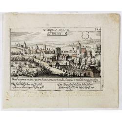
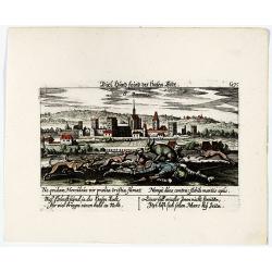
Villec.
A very nice view of Villec in Hungary (Fülek, Filakovo). In background a castle and in the foreground, a man examining a painting. With a verse in two languages undernea...
- $90 / ≈ €78
Date: Frankfurt, 1623-1678
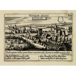
S. Iulius.
A very nice view of the castle. On the foreground, several frogs are depicted with a verse in two languages underneath the picture.The poet and topographer from Comothau,...
- $60 / ≈ €52
Date: Frankfurt 1623-1678
S. Iulius.
A very nice view of the castle of Saint Julius. On the foreground, several frogs are depicted. With a verse in two languages underneath the picture.The poet and topograph...
- $60 / ≈ €52
Date: Frankfurt, 1623-1678
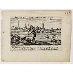
Aeqvum est, tristes secludere curas (Lianges.)
A very nice view of the city Lianges. With a verse in two languages underneath the picture.The poet and topographer from Comothau, Daniel Meisner (1585-1625), started his...
- $60 / ≈ €52
Date: Frankfurt, 1623-1678
![S. Victor in Franckr. [France].](/uploads/cache/13770-250x250.jpg)
S. Victor in Franckr. [France].
A very nice view of the church. On the foreground, a night watchman is depicted. With a verse in two languages underneath the picture.The poet and topographer from Comoth...
- $40 / ≈ €35
Date: Frankfurt, 1623-1678
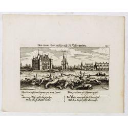
In einem Todt wollen alle zu Ritter werden.
A very nice view of a dead lion, surrounded by rabbits and in the background a French castle. With a verse in two languages underneath the picture. "In einem Todt, n...
- $70 / ≈ €61
Date: Frankfurt, 1623-1678
![S. Victor in Franckr. [The Abbey of St. Victor near Paris.].](/uploads/cache/13769-250x250.jpg)
S. Victor in Franckr. [The Abbey of St. Victor near Paris.].
A very nice view of the Abbey of St. Victor near Paris. On the foreground, a night watchman is depicted. With a verse in two languages underneath the picture.The poet Dan...
- $60 / ≈ €52
Date: Frankfurt, 1623-1678
S. Iulius.
A very nice view of the town. In the foreground, a bridge with several frogs are depicted with a verse in two languages underneath the picture.The poet and topographer fr...
- $80 / ≈ €69
Date: Frankfurt, 1623-1678
![In einem Todt. . . [ Chateau Chenonceaux ]](/uploads/cache/13817-250x250.jpg)
In einem Todt. . . [ Chateau Chenonceaux ]
A very nice depiction of Chateau Chenonceaux near Tours, France within the foreground is a dead lion, surrounded by rabbits. With a verse in two languages underneath the ...
- $50 / ≈ €43
Date: Frankfurt, 1623-1678
![Cordelirs in Franckr. [France].](/uploads/cache/13811-250x250.jpg)
Cordelirs in Franckr. [France].
A panoramic view of the town of Cordelirs (probably imaginary) with in center the church. On the foreground a man hunting a wolve. With a verse in two languages underneat...
- $35 / ≈ €30
Date: Frankfurt 1623-1678
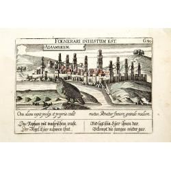
Azaamurum.
A very nice view of the town of Azemmour in Morocco. With a verse in two languages underneath the picture.The poet and topographer from Comothau, Daniel Meisner (1585-162...
- $80 / ≈ €69
Date: Frankfurt, 1623-1678
![Merla in Ob. Hessen. [Merlau]](/uploads/cache/13826-250x250.jpg)
Merla in Ob. Hessen. [Merlau]
A panoramic view of the castle and town of Merlau in Hessen. In the foreground, two men fighting each other are depicted. With a verse in two languages underneath the pic...
- $40 / ≈ €35
Date: Frankfurt, 1623-1678
![Cordelirs in Franckr. [France].](/uploads/cache/13799-250x250.jpg)
Cordelirs in Franckr. [France].
A very nice view of the town of Cordeliers. On the foreground, a man hunting a wolf is depicted. With a verse in German and Latin underneath the picture.The poet and topo...
- $80 / ≈ €69
Date: Frankfurt, 1623-1678
![Cordelirs in Franckr. [France].](/uploads/cache/13812-250x250.jpg)
Cordelirs in Franckr. [France].
A panoramic view of the town of Cordeliers (probably imaginary) with in the center the church. In the foreground a man hunting a wolf. With a verse in two languages under...
- $50 / ≈ €43
Date: Frankfurt 1623-1678
Stati della Corona di Polonia Divisa nella sue Principali Provincie e Palatinati da Guglielmo Sansone. . .
Rare map of Poland, Lithuania and the Ukraine. Copies of his first edition of 'Mercurio Geografico', published in 1674, do not contain a map of Poland. Only added in late...
- $1250 / ≈ €1082
Date: Rome, 1678
![S. Victor in Franckr. [Paris].](/uploads/cache/13781-250x250.jpg)
S. Victor in Franckr. [Paris].
A very nice view of St. Victor church in Paris. In the foreground, a night watchman is depicted. With a verse in Latin and German underneath the picture. The German text ...
- $60 / ≈ €52
Date: Frankfurt, 1623-1678
Vincennes - Viel hund Feind.des Hasen Todt.
A very nice picture representing Vincennes. With a verse in German and Latin. The German text reads : "Viel Hundt feind ja des Hasen Todr, Ihr viel bringn einen bald...
- $70 / ≈ €61
Date: Frankfurt, 1623-1678
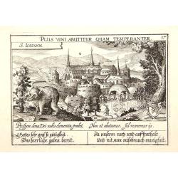
S. Iohann. Plus vini abutitur quam temperanter.
A very nice view of S.Johann Kloster with in the foreground, a wolf eating grapes. The Abbey of Saint John is an ancient Benedictine monastery in the Swiss municipality o...
- $70 / ≈ €61
Date: Frankfurt, 1623-1678
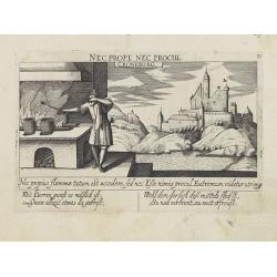
Croneburg.
A very nice picture representing the castle of Croneburg, of the German town of Kronenburg (now part of Dahlem). On the foreground, a man entertaining a fire is depicted....
- $75 / ≈ €65
Date: Frankfurt, 1623-1678
![Cordelirs in Franckr. [France].](/uploads/cache/13736-250x250.jpg)
Cordelirs in Franckr. [France].
A very nice view of a monastery. With a verse in two languages underneath the picture.The poet and topographer from Comothau, Daniel Meisner (1585-1625), started his firs...
- $40 / ≈ €35
Date: Frankfurt, 1623-1678
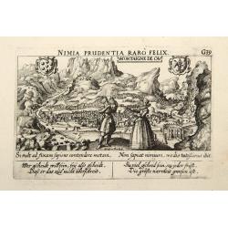
Montaigne de Ca.
In the foreground, a couple of which the man is holding a quadrant with a verse in two languages underneath the picture.The poet and topographer from Comothau, Daniel Mei...
- $85 / ≈ €74
Date: Frankfurt, 1623-1678
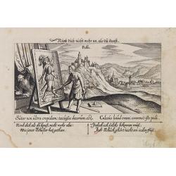
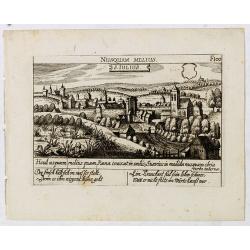
Villec.
A very nice view the town of Villeck in Czechoslovakia. On the foreground, a man examining a painting is depicted. With a verse in two languages underneath the picture.Th...
- $75 / ≈ €65
Date: Frankfurt, 1623-1678
S. Laurens in Escurial.
A very nice picture representing the monastery of San Lorenzo del Escorial. On the foreground the god Jano, with two faces. With a verse in two languages underneath the p...
- $90 / ≈ €78
Date: Frankfurt 1623-1678
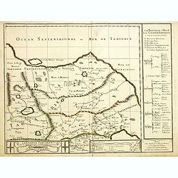
Lesser Tartaria.
A late seventeenth-century English map of Siberia / Tartary.A scarce little map with accompanying engraved text (94x55mm) from "Atlas Minimus, or, A book of geograph...
- $200 / ≈ €173
Date: London, 1679
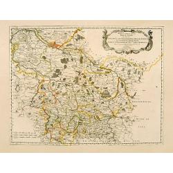
Haute Partie de la Basse Saxe..
Fine map of the northeastern part of Germany, including Hamburg and the rivers Wesel and Elbe. This edition carries the date 1679. Nicolas Sanson was to bring about th...
Date: Paris, 1679
![[Title page] Theatri Europaei, oder Beschreibung . . .](/uploads/cache/41395-250x250.jpg)
[Title page] Theatri Europaei, oder Beschreibung . . .
Title page.
- $80 / ≈ €69
Date: Frankfurt, Johann Görlin, 1679
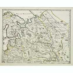
Moscovie dite autrement Grande et Blanche Russie.
Somewhat scarce map of the Russia centered on Moscow, including Finland.
- $450 / ≈ €389
Date: Paris, 1679
Description de la Tartarie. . .
Detailed map of Tartary, northern China and Korea as an island. The Caspian Sea in the utmost left. Numerous place-names of counties, cities, towns, physical features.Ala...
- $250 / ≈ €216
Date: Paris, 1679
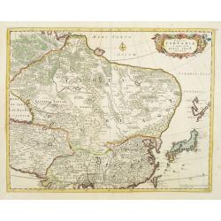
Tabula Tartariae et majoris partis regni Chinae.
Stretching from the Caspian Sea in the west to Formosa in the south-east. Including the peninsula of Korea, Japan and the east coast of Yedso. The Great Wall of China is ...
Date: Amsterdam, 1680
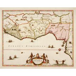
Guinea.
A close copy of the map by Blaeu. Covers the Guinea and Benin coast. A very decorative map with a large title cartouche. At bottom right two putti area carrying an elepha...
- $1000 / ≈ €865
Date: Amsterdam, 1680
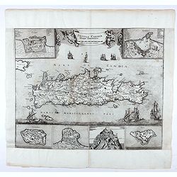
Insula Candia ejusque fortificatio.
An earlier and smaller version of De Wit's map of Candia. Richly engraved work, one of the most beautiful ever produced of Crete. There are insets of the fortifications a...
- $2500 / ≈ €2164
Date: Nuremberg, 1680
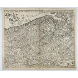
Comitatus Flandriae Tabula, In Lucem Edita A Frederico De Wit.
Double page map of Flanders, the whole Belgian region northwest of Brussels, confined by Antwerp, Brussels, valenciennes, Arras, St. Omer and the Channel. Title heading a...
Date: Amsterdam, 1680
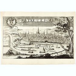
Treves (Trier)
Rare and decorative view of the city of Trier and the river Moselle in the foreground. In the upper left corner the coat of arms of France. The Jollain family was a famil...
Date: Paris, 1680
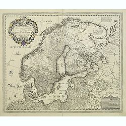
Tabula exactissima Regnorum Sueciae et Norvegiae..
Very fine and uncommon map of Scandinavia, after Andreas Buraeus, the father of Swedish cartography, whose map was compiled from original survey work. Dedicated to Gustav...
- $750 / ≈ €649
Date: Amsterdam, 1680