Browse Listings

'T Ryk van Persien.
An attractive miniature prepared by N. Sanson. Engraved by A.de Winter.
- $100 / ≈ €87
Date: Amsterdam, Utrecht, Halma, 1680
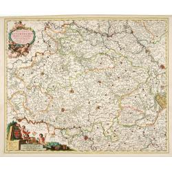
Ducatus Lutzenburgi Novissima et Accuratissima Delineatio.
West to the top. Very detailed and fine map of Luxembourg, including the towns of Namur, Liege, Trier and Metz.
Date: Amsterdam, 1680
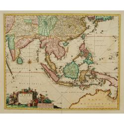
Indiae Orientalis nec non Insularum adiacentium.
Fine map of South East Asia from India to New Guinea with Japan and the southern tip of Korea in the upper right. The map leaves the question of Torres Straits unanswered...
- $1800 / ≈ €1558
Date: Amsterdam, 1680
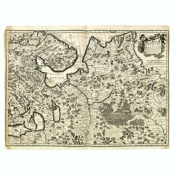
Nouvelle Carte geographique du Grand Royaume de Moscovie. . .
Scarce and detailed map centered on Moscow. Showing to the right the river Wolga and Azof in the south.
- $600 / ≈ €519
Date: Amsterdam, 1680
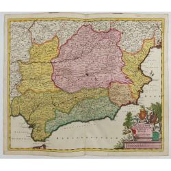
Regnorum Castellae, Novae, Andalujsae, Granadae, Valentae, et Murciae Accurata Tabula
Decorative map of Southern Spain, extending from Salamanca and Segovia in the North, to the Gulfs of Valentia, Alicante and Cartagena in the east, the Straits of Gibralta...
Date: Amsterdam, 1645-1680
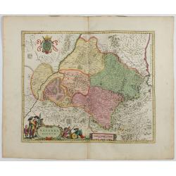
Navarra Regnum.
RARE : The signature by Willem Blaeu in the lower right corner has been erased. The copperplate was published by Frederick de WitDecorative map of the region which includ...
Date: Amsterdam, 1645-1680
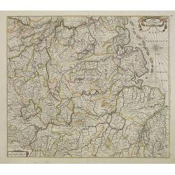
Nova Totius Westphaliae descriptio.
Map of the northern provinces of Germany, including the Wad islands. West to the top. Including Bremen, Hildesheim, Kassel, Düsseldorf, etc. Also including the Dutch pro...
Date: Amsterdam, 1680
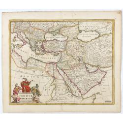
Turcicum Imperium.
Detailed map of the Turkish Empire by Holland's leading mapmaker at the end of the seventeenth century. The cartouche shows an Ottoman administrator or possibly the Sulta...
Date: Amsterdam, 1680
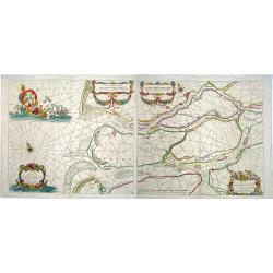
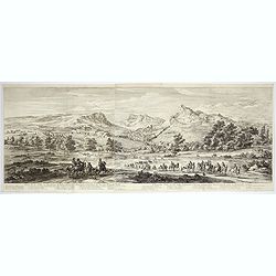
Paskaerte van het inkoomen van de MAES, Tot aen 't Eylandt Roosenburgh als mede 't Inkoomen van 't Goereesche Gat.. / Pascaert van 't Eylandt Roosenburg door de Oude en Nieuwe Maes....
A very attractive sea chart on two sheets of the mouth of the river Maas. The left sheet shows Dordrecht, Rotterdam and the fortress at Willemstad. Rghthand sheet dep...
Date: Amsterdam, 1680
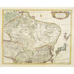
Tabula Tartariae et majoris partis regni Chinae.
Stretching from the Caspian Sea in the west to Formosa in the south-east. Including the peninsula of Korea, Japan and the east coast of Yedso. The Great Wall of China is ...
Date: Amsterdam, 1680
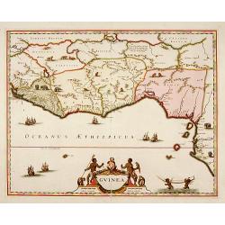
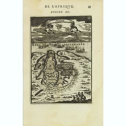
Guinea.
A close copy of the map by Blaeu. Covers the Guinea and Benin coast. A very decorative map with a large title cartouche. At bottom right two putti area carrying an elepha...
- $1000 / ≈ €865
Date: Amsterdam, 1680

Belgium Foederatum emendate auctum et novissimé editum.
Fine detailed map of the area of the modern Netherlands less the southern part of Limburg. Title cartouche representing the commerce, the arts and the sciences. The Lion ...
Date: Amsterdam, 1680
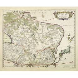
Tabula Tartariae et majoris partis regni Chinae.
Stretching from the Caspian Sea, Central Asia, and the West to Formosa, in the southeast. Including the peninsula of Korea, Japan, Taiwan and the east coast of Yedso. It ...
- $750 / ≈ €649
Date: Amsterdam, 1680
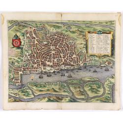
Goa.
A finely engraved, detailed town-plan of Goa, the main Portuguese trading post in India. It also appeared in Gottfried’s Archontologia (1649). There is a cartouche iden...
Date: Frankfurt, 1680

Sinus Gangeticus vulgo Golfo de Bengala Nova descriptio.
Showing the east coast of India and Sri Lanka. West to the top. Decorated with two compass roses, six vessels, a figurative title cartouche and a scale cartouche. The map...
- $500 / ≈ €433
Date: Amsterdam, 1680

Pas-kaart vande Zee kusten van Venecuela met de Byleggende Eylanden. . .
Rare chart of the coast of Venezuela, including the islands of Curaçao, Bonaire, Aruba, etc.The chart has two insets, one (15x22cm) with a map of Curaçao, one smaller w...
Date: Amsterdam, 1680
Veue de la ville, et fauxbourg de Salins…
Showing the town of Salins, a commune with salt works (Salines) in the Jura department in the region of Bourgogne-Franche-Comté in eastern France. With a key (1-15) in ...
- $700 / ≈ €606
Date: Paris, ca. 1680
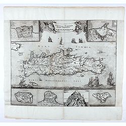
Insula Candia ejusque fortificatio.
An earlier and smaller version of De Wit's map of Candia. Richly engraved work, one of the most beautiful ever produced of Crete. There are insets of the fortifications a...
- $2500 / ≈ €2164
Date: Nuremberg, 1680
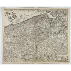
Comitatus Flandriae Tabula, In Lucem Edita A Frederico De Wit.
Double page map of Flanders, the whole Belgian region northwest of Brussels, confined by Antwerp, Brussels, valenciennes, Arras, St. Omer and the Channel. Title heading a...
Date: Amsterdam, 1680
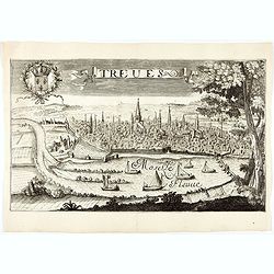
Treves (Trier)
Rare and decorative view of the city of Trier and the river Moselle in the foreground. In the upper left corner the coat of arms of France. The Jollain family was a famil...
Date: Paris, 1680
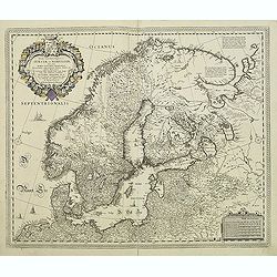
Tabula exactissima Regnorum Sueciae et Norvegiae..
Very fine and uncommon map of Scandinavia, after Andreas Buraeus, the father of Swedish cartography, whose map was compiled from original survey work. Dedicated to Gustav...
- $750 / ≈ €649
Date: Amsterdam, 1680
Naukeurige Beschryving van Asie: behelsende de Gewesten van Mesopotamie, Babylonie, Assyrie, Anatolie, of Klein Asie: beneffens eene volkome Beschrijving van gansch Gellukigh, Woest, en Petreesch of Steenigh Arabie.
Fine large paper copy of this important description of the Near East and Arabia, illustrated with numerous text engravings, 15 double page engraved maps (3) and views (12...
Date: Amsterdam, Jacob van Meurs, 1680

Mare Balticum. . . / Nieuwe Pascaert van de Oost Zee. . .
Decorative chart showing the Baltic sea, with a splendid cartouche of royal figures. A re-issue of the De Wit copper plates, now with many improvements.
- $2500 / ≈ €2164
Date: Amsterdam ca.1680
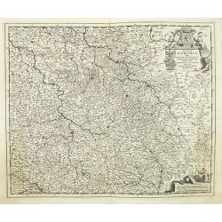
Regnum Bohemia.. Silesia.. Moravia, et Lusatia..
Detailed map of Czechoslovakia including the towns of Dresden, Prague, Breslau, etc. With fine title cartouche upper left, putti carrying the coats of arms of Bohemia, Mo...
- $400 / ≈ €346
Date: Amsterdam, 1680

The Sea Coasts of France from Olone to Cape Machicaca in Biscay . . .
Detailed chart of Biscay Bay, showing the Coast of Brittany. The chart is oriented with north-east at the top and includes two large insets of the Loire River with Nantes...
Date: London, ca. 1680
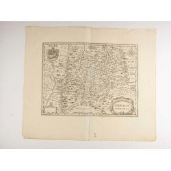
Erpach.
The town of Heidelberg is in most southern point on the map, including the rivers Rhine, Necker and Main.Rare issue published in Oxford. In 1680 the copper plates of Jans...
- $100 / ≈ €87
Date: Oxford, 1680

The Sea Coast of France from Ushent to Olone.
Chart showing the Brittany coast from Ushent to Ollone, with Belle-Ile. In insets : Rade de Brest and Mouth of the Loire between St. Nazaire and Nantes.Originally engrave...
Date: London, ca. 1680
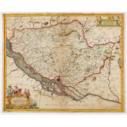
Tabula Geographica Novissima Ducatus Stormariae in Meridionali Parte Holsatiae.
A rare and beautiful map of the region of Germany around Hamburg. Fine detailed topography, including roads, fortifications, cities and villages. The title cartouche is s...
Date: Amsterdam, 1681

Pascaerte van Carybes, Nieu Neder landt, Brazil. . .
This progenitor chart covers the American shores of the Atlantic Ocean. This chart by Theunis Jacobsz. was most probably engraved close to his death in 1650 or shortly af...
- $2200 / ≈ €1904
Date: Amsterdam, 1653-1681
![Abbaye d'Hautecombe. [Hautecombe Abbey]](/uploads/cache/45512-250x250.jpg)
Abbaye d'Hautecombe. [Hautecombe Abbey]
Showing in great detail a bird's-eye view of the Hautecombe Abbey, a former Cistercian monastery, later a Benedictine monastery, in Saint-Pierre-de-Curtille near Aix-les-...
- $150 / ≈ €130
Date: Amsterdam, 1682
![Rumiliacum vulgo Rumilix. [Rumilly]](/uploads/cache/45513-250x250.jpg)
Rumiliacum vulgo Rumilix. [Rumilly]
Showing in great detail a bird's-eye view of the city of Rumilly in the Haute-Savoie, decorated with the coat of arms and a lettered key.From "Theatrum Sabaudiæ&quo...
- $150 / ≈ €130
Date: Amsterdam, 1682
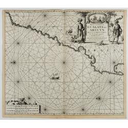
Paskaart van de Kuste van, Gualate en Arguyn. Beginnende van C. Bajador tot C. Blanco. . .
A nautical showing the northwestern coast of Africa, along Western Sahara from Cape Bojador to Cape Blanc. Ornate title cartouche in top right corner shows two main figur...
Date: Amsterdam, ca.1682

Histoire de la République de Venise.
The History of the Republic of Venice Historia della Republica Veneta (dal 1613 al 1671), in Italian, which goes from 1613 to 1671, was translated by François Tallemant,...
- $1800 / ≈ €1558
Date: Cologne, Pierre Marteau, 1682
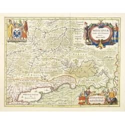
Moscovia pars Australis.
Prepared by Isaac Massa, a Dutch map-maker who traveled to Russia, returning to Holland in 1609, bringing with him a large amount of original cartographic manuscript mate...
- $1000 / ≈ €865
Date: Oxford, 1682
![Abbaye d'Hautecombe. [Hautecombe Abbey]](/uploads/cache/45509-250x250.jpg)
Abbaye d'Hautecombe. [Hautecombe Abbey]
Showing in great detail a bird's-eye view of the Hautecombe Abbey, a former Cistercian monastery, later a Benedictine monastery, in Saint-Pierre-de-Curtille near Aix-les-...
Date: Amsterdam, 1682

Paskaart van de kust van Maroca beginnende van Larache tot aan C. Cantin. . .
A nautical sea chart of the coast of Morocco. Insert at top right: 'Nieuwe Afbeelding van de Rivier Rio Rebata in 't Groot".Bottom right: chart number '32'. Compass ...
Date: Amsterdam, ca.1682
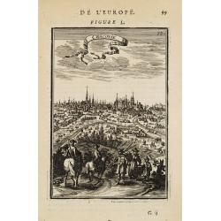
![France en general. [de l'Europe / Figure LXVII] 147](/uploads/cache/38437-250x250.jpg)
France en general. [de l'Europe / Figure LXVII] 147
A fine and uncommon early 17th century map of France.From the French text edition of "Description d'Univers", 1683. by Allain Manneson Mallet (1630-1706), a wel...
- $30 / ≈ €26
Date: Paris, 1683
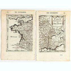
Carte generale de France.
A two-page map of France.Title in curtain draped at top. French text on verso.From the original 1683 text edition of "Description d'Univers. . ." by Allain Mane...
Date: Paris, 1683
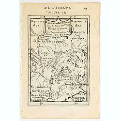
Royaume des… Royaume de Bourgogne sous la race des rois Bourguigons.
Map of Bourgogne region.Title in curtain draped at topFrom the original 1683 text edition of "Description d'Univers. . ." by Allain Manesson Mallet (1630-1706),...
Date: Paris, 1683
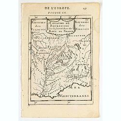
Royaume de Bourgogne sous la seconde race des roys de France.
Map of Bourgogne region.Title in a curtain draped at topFrom the original 1683 text edition of "Description d'Univers. . ." by Allain Manesson Mallet (1630-1706...
Date: Paris, 1683
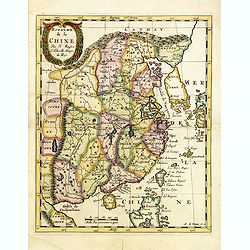
Royaume de la Chine. . .
Detailed map of China. Engraved by A.Winter. Attractive miniature map, depicting Korea as an island and parts of Japan, i.e. western part of Honshu and Kyushu.
- $450 / ≈ €389
Date: Utrecht, 1683
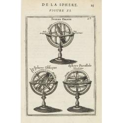
De la Sphere. Figure XI.
Appealing print of three armillary spheres.From the French text edition of Description d'Univers.. (5 volumes), 1683. By Allain Manneson Mallet (1630-1706), a well travel...
Date: Paris, 1683
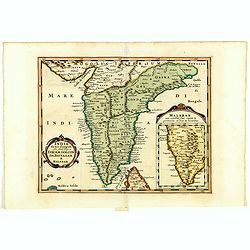
India extra Gangem . . .
Map covering the subcontinent from the Bay of Bengal and the Gulf of Cambay to Ceylon (Sri Lanka) and offers impressive detail given that the interior of India was largel...
- $300 / ≈ €260
Date: Utrecht / Amsterdam, J.Halma, 1683
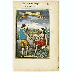
P.les du Chile.
A charming copper engraving depicting a town surrounded by a luxuriant landscape on the background and a couple of indigenous on the foreground.From the French text editi...
- $60 / ≈ €52
Date: Paris, 1683
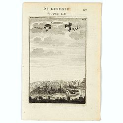
![Ancienne Gavle. [de l'Europe]](/uploads/cache/38440-250x250.jpg)
Ancienne Gavle. [de l'Europe]
A fine and uncommon early 17th century map of France.From the French text edition of "Description d'Univers", 1683. by Allain Manneson Mallet (1630-1706), a wel...
- $50 / ≈ €43
Date: Paris, 1683
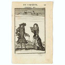
François.
A charming engraving of a French couple in 17th-century dress.Title in a curtain draped at top. French text on verso.From the original 1683 text edition of "Descript...
Date: Paris, 1683
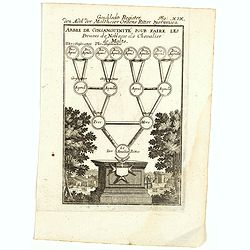
Arbre de Consanguinite Pour Faire Les Preuves de Noblesse de Chevalier de Malte.
An attractive piece that loosely translates to: Tree of Consanguinity To prove of Nobility of Knight of Malta. From Mallet's monumental Description de l' Univers, first p...
- $80 / ≈ €69
Date: Paris, 1683
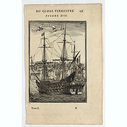
Vaisseau.
Miniature view of a vessel, showing its various corposants. With key list on verso.From the French text edition of Description d'Univers.. (5 volumes), 1683. By Allain Ma...
- $80 / ≈ €69
Date: Paris, 1683
Chamberi.
A charming view of Chambery. Title in a curtain draped at top. French text on verso.From the original 1683 text edition of "Description d'Univers. . ." by Allai...
Date: Paris, 1683
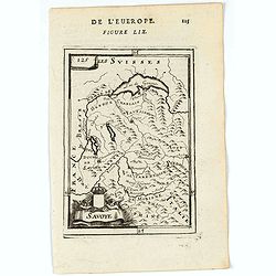
Savoye.
A charming map of Savoy. Title in a curtain draped at top. French text on verso.From the original 1683 text edition of "Description d'Univers. . ." by Allain Ma...
Date: Paris, 1683
Molucquois (De L'Asie / figure LX).
A fine and uncommon early 17th century print of two people from Moluccas.From the French text edition of "Description d'Univers", 1683. by Allain Manneson Malle...
- $80 / ≈ €69
Date: Paris, 1683
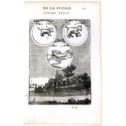
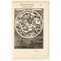
DE LA SPHERE. Figure XXXVII. 103.
Fine celestial map depicting three constellations in allegorical form. The 3 spheres are suspended above an engraved scene of a harbor on a moonlit night.From the French ...
- $100 / ≈ €87
Date: Paris, 1683
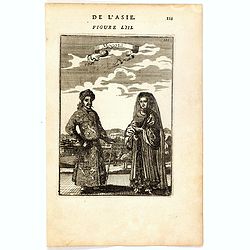
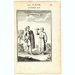
Mongols (De L'Asie / figure LIII).
A fine and uncommon early 17th century print of a Mogol couple.From the French text edition of "Description d'Univers", 1683. by Allain Manneson Mallet (1630-17...
- $80 / ≈ €69
Date: Paris, 1683
Ardeuil ou Ardebil.
A fine and uncommon early 17th century birds-eye view of Ardeuil in Iran, Persia.From the French text edition of Description d'Univers, 1683. by Allain Manneson Mallet (1...
- $80 / ≈ €69
Date: Paris, 1683
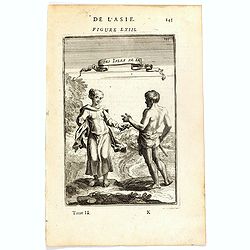
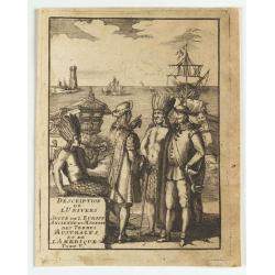
Habitants des Isles de la Sonde.
A fine and uncommon early 17th century print of two inhabitants of the Sunda Islands, East Indies (Indonesia).From the French text edition of Description d'Univers, 1683....
- $75 / ≈ €65
Date: Paris, 1683
(title page) Description de L'Univers suite de L'Europe ancienne et moderne des terres Australes et de L'Amerique Tome V.
Showing arrival of Francis Drake in the New World.
- $150 / ≈ €130
Date: France, 1683
Cracovie.
View of Krakow. From the French text edition of Description d'Univers... By Allain Manesson Mallet (1630-1706), a well-traveled military engineer and geographer who worke...
- $300 / ≈ €260
Date: Paris, 1683

Allain Manesson Mallet Pairisi, Ingeni Des Camps Et Armees du Roy de Protugal.
Portrait of Alain Manesson Mallet, engraved by Pierre Landry, from "Description de l'Univers".
- $110 / ≈ €95
Date: Paris, 1683
![La Voye Laictee, Pole Arctique. [Figure XXXIX. On verso]](/uploads/cache/22619-250x250.jpg)
La Voye Laictee, Pole Arctique. [Figure XXXIX. On verso]
Nice small celestial chart showing the northern sky with ten major constellations named. Fine engravure on verso depicting a cherubin using an astronomical telescope.From...
- $200 / ≈ €173
Date: Paris, 1683
DE LA SPHERE. Figure XXXVI.
A fine celestial map depicting the southern constellations in allegorical form. Fully engraved, it presents a landscape with some sailing ships on the background.From the...
- $200 / ≈ €173
Date: Paris, 1683
Isle de Malthe.
A charming late 17th century French map of Malta and Gozo with a large pictorial cartouche depicting Neptune and a mermaid, a nautical sailing ship scene across the botto...
- $250 / ≈ €216
Date: Paris, 1683
Malte.
A charming late 17th century French plan of La Valletta. With a ribbon style title cartouche and a nautical sailing ship scene across the top.By Allain Manneson Mallet (1...
- $225 / ≈ €195
Date: Paris, 1683
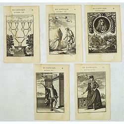
Set of 5 Malta related copper engravings.
Set of 5 Malta-related copper engravings from the French edition of the "Description De L'Univers" by Allain Manesson Mallet. French edition, 1683..By Allain Ma...
- $200 / ≈ €173
Date: Paris, 1683
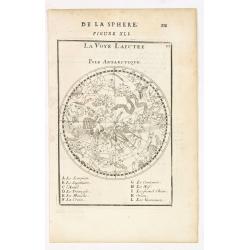
La Voye Laictee, Pole Antarctique.
Nice small celestial chart showing the southern sky with eleven major constellations named.From the French text edition of Description d'Univers.. (5 volumes), 1683. By A...
- $300 / ≈ €260
Date: Paris, 1683
![Carte generale de France. [de l'Europe]](/uploads/cache/38442-250x250.jpg)
Carte generale de France. [de l'Europe]
A fine and uncommon early 17th century map of France printed from two copper plates. Engraved by Liébaux.From the French text edition of "Description d'Univers"...
- $80 / ≈ €69
Date: Paris, 1683
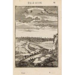
Iedo. (Tokyo)
A late 17th-century miniature view of the skyline of Edo (Tokyo). By Allain Manesson Mallet (1630-1706), a well-traveled military engineer and geographer who worked in 17...
- $200 / ≈ €173
Date: Paris, 1683
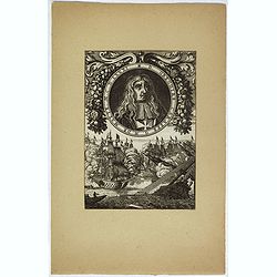
D. Gregoire Caraffe G. M. de Malte. M.C.D.LXXXI.
Portrait of Gregorio Carafa (1615 - 1690), 62nd Prince and Grand Master of the Order of Saint John (Knights of Malta) 1680 until his death in 1690.The sea battle undernea...
- $30 / ≈ €26
Date: Paris, Denys Thierry, 1683
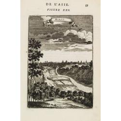
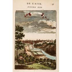
Miaco.
A late 17th-century miniature view of the skyline of Miaco (Kyoto). By Allain Manesson Mallet (1630-1706), a well-traveled military engineer and geographer who worked in ...
- $200 / ≈ €173
Date: Paris, 1683
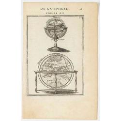
DE LA SPHERE. Figure XII.
A fine 17th-century depiction of a floor globe with a turned wooden leg base, the globe displaying an enormous southern continent. Atop this is a wonderful miniature tabl...
- $150 / ≈ €130
Date: Paris, 1683
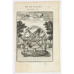
Des Colures.
Appealing print focused on an armillary sphere showing the equinoctial and the solstitial colures.From the French text edition of Description d'Univers.. (5 volumes), 168...
- $150 / ≈ €130
Date: Paris, 1683
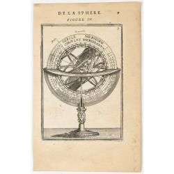
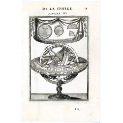
DE LA SPHERE. Figure III.
Appealing print focused on an armillary sphere. The latter is surmounted by a cartouche containing some angles in a circle.From the French text edition of Description d'U...
- $200 / ≈ €173
Date: Paris, 1683
DE LA SPHERE. Figure II.
Appealing print depicting an armillary sphere.From the French text edition of Description d'Univers.. (5 volumes), 1683. By Allain Manneson Mallet (1630-1706), a well tra...
- $150 / ≈ €130
Date: Paris, 1683
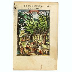
Hurons.
Attractive copper engraving, depicting Huron Indians or Wynadot / Wendat people hunting and gathering .From the French text edition of Description d'Univers, 1683. by All...
- $75 / ≈ €65
Date: Paris, 1683
Tartaria sive Magni Chami imperium.
Detailed and decorative map of Tartary and Northern part of China. Northern tip of Korea included. The Chinese Great Wall is depicted.
- $120 / ≈ €104
Date: Amsterdam, 1683
![De l'Europe. [ Figure LXXXV].](/uploads/cache/38452-250x250.jpg)
De l'Europe. [ Figure LXXXV].
Decorative engraving showing "Ludovicus Magnus" or Louis XIV King of France, Coin Portrait.From the French text edition of "Description d'Univers", 16...
- $50 / ≈ €43
Date: Paris, 1683
![Isole dell 'India cioè le Molucche le Filippine e della Sonda . . . [East Indies].](/uploads/cache/39593-250x250.jpg)
Isole dell 'India cioè le Molucche le Filippine e della Sonda . . . [East Indies].
In lower left hand corner a large title cartouche, decorated with mermaids, mermen and playful putti. A scarce, uncommon, late 17th century map of South East Asia, based ...
- $1800 / ≈ €1558
Date: Rome, 1683
Miaco.
A late 17th-century miniature view of the skyline of Miaco (Kyoto). By Allain Manesson Mallet (1630-1706), a well-traveled military engineer and geographer who worked in ...
- $225 / ≈ €195
Date: Paris, 1683
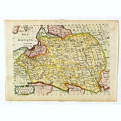
Estats de la Couronne de Pologne.
Map of Poland prepared by N.Sanson and published by F. Halma.Published in an Dutch edition of the small Sanson atlas L'Europe Dediée a Monseigneur . . . Le Tellier Secre...
Date: Amsterdam, Utrecht, 1683
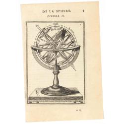
DE LA SPHERE. Figure III. 7
Appealing print focused on an armillary sphere. The latter is surmounted by a cartouche containing some angles in a circle.From the French text edition of Description d'U...
- $150 / ≈ €130
Date: Paris, 1683
![Grande prefecture des Gavels. [de l'Europe / Figure LX] 135](/uploads/cache/38436-250x250.jpg)
Grande prefecture des Gavels. [de l'Europe / Figure LX] 135
A fine and uncommon early 17th-century map of Europe.From the French text edition of "Description d'Univers," 1683. by Allain Manneson Mallet (1630-1706), a wel...
- $30 / ≈ €26
Date: Paris, 1683