Browse Listings
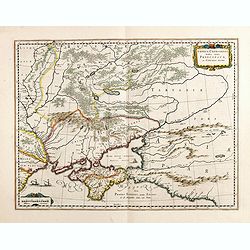
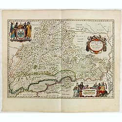
Taurica Chersonesus, Nostra aetate Przecopsca, et Gazara dicitur.
Detailed map of the Ukraine, Russia with in the north Smolensk and Moscow and in the south the Black Sea. Shows ports, fortified cities and the mouths of the Danube. Mino...
- $750 / ≈ €649
Date: Amsterdam, 1645
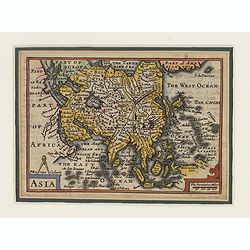
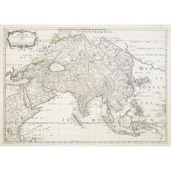
Asia.
This lovely rare miniature map of the continent of Asia is a single page with text on verso taken from John Speed's folio atlas, and is signed with Van den Keere's Latini...
- $275 / ≈ €238
Date: London, 1646
![Ins. de Cerno a. Nostatibus Mauritius Nominata [on sheet with] Gunnanappi Labetacq [and] Civitas Gammelamme [and] Rex Tubatus.](/uploads/cache/48504-250x250.jpg)
Ins. de Cerno a. Nostatibus Mauritius Nominata [on sheet with] Gunnanappi Labetacq [and] Civitas Gammelamme [and] Rex Tubatus.
Three views and one map on one page: Shows natives on Mauritius fishing and building a boat, with a dodo and two turtles at right; The Banda islands; A procession for th...
Date: Amsterdam, c.1646
Territorium Abbatiae Herefeldensis - 't Stift Hirszfeldt.
Detailed map centered on Hirschfelt. Title cartouche embellished with two cherubs.
- $250 / ≈ €216
Date: Amsterdam, 1647
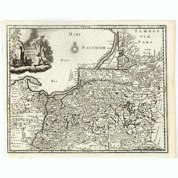
Prussiae nova tabula.
Rare map of Prussia with nowadays Poland. The map features a bold title cartouche, a ship, compass rose, and a sea monster in the Baltic Sea. The map was prepared by the ...
- $550 / ≈ €476
Date: Amsterdam, 1647
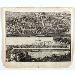
Kom - Kaschan.
An early of Kom and Kaschan on one sheet. From the rare first edition "Offt begehrte Beschreibung der newen orientalischen Rejse, so durch Gelegenheit einer Holstei...
- $250 / ≈ €216
Date: Schleßwig, Zur Glocken, 1647
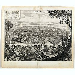
Isfahan.
An early of Isfahan in central Iran,. From the rare first edition "Offt begehrte Beschreibung der newen orientalischen Rejse, so durch Gelegenheit einer Holsteinisc...
- $250 / ≈ €216
Date: Schleßwig, Zur Glocken, 1647
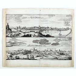
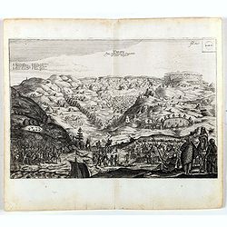
Die stadt Narva . . .
Two panoramic views of the city of Narva, on one sheet. Narva is the third largest city in Estonia. It is located at the eastern extreme point of Estonia, at the Russian...
- $250 / ≈ €216
Date: Schleßwig, Zur Glocken, 1647
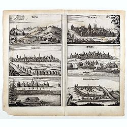
Tetus - Samara - Soratof - Zariza - Tzornogar - Kusmamedianski.
Panoramic views of Tetus, Samara, Soratof, Zariza, Tzornogar and Kusmamedianski on one sheet. From the rare first edition "Offt begehrte Beschreibung der newen orien...
- $300 / ≈ €260
Date: Schleßwig, Zur Glocken, 1647
Tarku.
An early of Tarku in the Republic of Dagestan. From the rare first edition "Offt begehrte Beschreibung der newen orientalischen Rejse, so durch Gelegenheit einer Ho...
- $250 / ≈ €216
Date: Schleßwig, Zur Glocken, 1647
![De Bello Belgico, Decas PrimaDeces II. [with 2 Leo Belgicus maps]](/uploads/cache/21542-250x250.jpg)
De Bello Belgico, Decas PrimaDeces II. [with 2 Leo Belgicus maps]
Each volume contains an engraved title with a representation of the Netherlands and Belgium in the shape of a lion, with one paw resting on a shield bearing the title, a ...
Date: Rome, Franciscus Corbelletus, 1632-1647
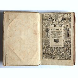
Traduzida palabra por palabra de la verdad Hebrayca, por muy excelentes letrados.
Complete title : Traduzida palabra por palabra de la verdad Hebrayca, por muy excelentes letrados. Vista y examinad a per el officio de la Inquisicion. Con Privilegio del...
- $8500 / ≈ €7356
Date: Ampsterdam, Gillis Ioost, 1647
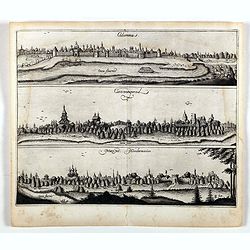
Colomna - Cassimogorod - Moruma.
Three panoramic views of Colomna - Cassimogorod - Moruma on one sheet. From the rare first edition "Offt begehrte Beschreibung der newen orientalischen Rejse, so dur...
- $300 / ≈ €260
Date: Schleßwig, Zur Glocken, 1647
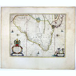
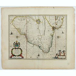
Brasilia.
Striking old color example of Blaeu's second map of Brazil prepared by Krystof Arciszewski, a Polish general who worked for the Dutch West Indian Company. The map perpetu...
- $750 / ≈ €649
Date: Amsterdam, 1647
Brasilia.
Fine copy of this map by Krystof Arciszewski, a Polish general who worked for the Dutch West Indian Company. The map perpetuates various myths including the Parime Lago ,...
Date: Amsterdam, 1647
Geographische Beschryvinge van de wandeling der Apostelen. . .
Finely engraved detailed map covering the whole of the eastern Mediterranean. Showing the travels of the apostles after the death of Christ, with episodes from the life o...
Date: Amsterdam, 1648
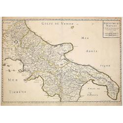
Royaume de Naples..
Fine map of the southern part of Italy.This edition carries the date 1648, engraved by AB. De la plaets. With the manuscript number in the upper right corner.Nicolas Sans...
Date: Paris, 1648
La ville archie-piscopale et primatiale de Vienne en Dauphiné.
View of Vienne, engraved by François de La Pointe.
- $600 / ≈ €519
Date: Paris, 1648
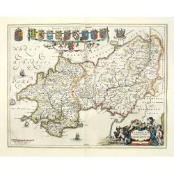
Penbrochia Comitatus et Comitatus Caermaridunum.
Attractive map of the country of Pembroke shire in UK by J. Blaeu. From a Dutch edition of "Atlas Maior" in beautiful color. With 13 coats of arms, the feathere...
Date: Amsterdam, 1648
Ducatus Silesiae Glosani.
Charming map of the Silesia from the Mercator Hondius “Atlas Minor” published in Amsterdam in 1648 at Janssonius with German text on verso. Engraved by Petrus Kaerius...
- $200 / ≈ €173
Date: Amsterdam, 1648
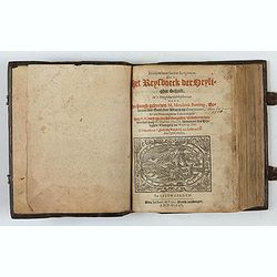
Itinerarium Sacrae Scripturae, dat is, Het Reysboeck der heyligher Schrift
This is a scarce 1648 Dutch edition of Büntings "Itinerarium Sacrae Scripturae" printed in Leeuwarden. The book includes 6 folding maps and 2 plates. The book ...
- $3000 / ≈ €2596
Date: Leeuwarden, de Vries, Jan Jansz., 1648
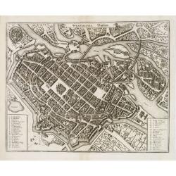
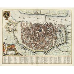
Wratislavia. Bresslaw.
Decorative town-plan of the Polish city of Wroclaw, once known as Breslau. The engraving is by the famed Swiss engraver Matthew Merian. A numbered key (1 - 38) the corner...
- $600 / ≈ €519
Date: Frankfurt, ca. 1649
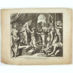
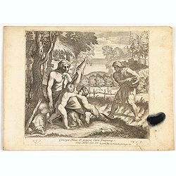
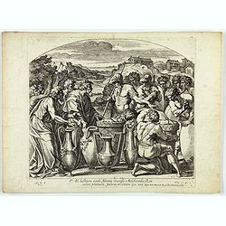
Saba Aethiopum Regina venit ad Salomonem, cum magnis Opibus aromatum, Auri, ac Gemmarum. ( Plate 47)
Very nice etching by Nicolas Chapron, after Raphaël's (Raffaello Sanzio) frescoes in the Vatican Loggia. Scene illustrating the visit of the Queen of Sheba at her visit ...
Date: Paris, Petrus Mariette, 1649
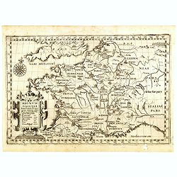
Regnum Galliae. . .
Map of France from the rare atlas of the Capucin order: "Chorographica descriptio provinciarum, et conventum fratrum minorum S. Francisci Capucinorum…".
Date: Turin, 1649
Antverpia, Gallis Anvers. Vernacule Antwerpen.
Detailed plan of the city of Antwerp with extensive key to principal buildings. Lower left title cartouche with two coats of arms and Mercurius.
Date: Amsterdam, 1649
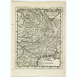
La partie orientale de la Grande Aquitaine.
Map taken from "Geographique Theater de l'Europe …, a rare work by the Jesuit priest Briet.
Date: Paris, 1649
Cataractae coeli apertoe funt: Et aguae proealuerunt super terram comfumptag Est omnis caro . . . (Plate 10)
Very nice etching by Nicolas Chapron, and after Raphaël's (Raffaello Sanzio) frescoes in the Vatican Loggia. Scene illustrating the moment when God said to Noah "Go...
- $50 / ≈ €43
Date: Paris, Petrus Mariette, 1649
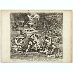
Concepit Heua & peperit Cain fratremg eius Abel. . . . (Plate 8)
Very nice etching by Nicolas Chapron, after Raphaël's (Raffaello Sanzio) frescoes in the Vatican Loggia. Scene illustrating Cain and Abel, a scene from Genesis IV.From t...
- $50 / ≈ €43
Date: Paris, Petrus Mariette, 1649
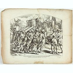
Portantes Arcam sacerdotes . . . (Plate 37)
Very nice etching by Nicolas Chapron, after Raphaël's (Raffaello Sanzio) frescoes in the Vatican Loggia. Scene illustrating Priests carrying the Ark through the River Jo...
- $25 / ≈ €22
Date: Paris, Petrus Mariette, 1649
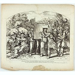
Arca Dni septies circuit Ciuitatem et clangentib tubis. Jericho corruerunt Moenia. Iosue. CVI. ( Plate 38)
Very nice etching by Nicolas Chapron, after Raphaël's (Raffaello Sanzio) frescoes in the Vatican Loggia. Scene illustrating the walls of Jericho crumbling.From the first...
- $25 / ≈ €22
Date: Paris, Petrus Mariette, 1649
Cataractae coeli apertoe funt: Et aguae proealuerunt super terram comfumptag Est omnis caro . . . (Plate 13)
Very nice etching by Nicolas Chapron, and after Raphaël's (Raffaello Sanzio) frescoes in the Vatican Loggia. Scene illustrating the moment when God said to Noah "Go...
- $25 / ≈ €22
Date: Paris, Petrus Mariette, 1649
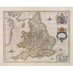
Anglia Regnum.
Willem Blaeu was the first publisher to bring out a new map of England and Wales. The outline and place names are taken from Speed with county boundaries marked but no bo...
- $500 / ≈ €433
Date: Amsterdam, 1650
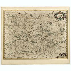
Aniou. . .
Decorative map centered on the Loire valley. Fine title cartouche in upper right corner.
Date: Amsterdam, 1650
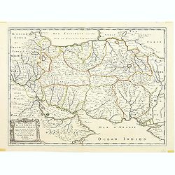
Description de l'Empire du Sophi des Perses tiree en partie de l'Arabe de Nubie, et en partie de plusieurs et diverses Relations.
The map of the Empire of Persia is shown to extend from Baghdad almost to the present-day borders of India. Including part of Saudi Arabia and Oman. Including "Golfe...
Date: Paris, 1650
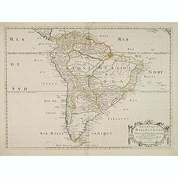
Amerique Meridionale. Par N.Sanson d'Abbeville. . .
The first edition of a cornerstone South America map, the first to show the boundaries of many countries, regions, and provinces. Peru is shown governing a huge tract of ...
- $500 / ≈ €433
Date: Paris, after 1650
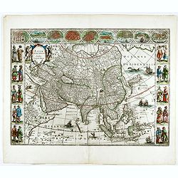
Asia noviter delineata..
From 1633 the members of the Blaeu family were official cartographers to the United East India Company and, as such, had access to the most up-to-date cartographic inform...
- $3500 / ≈ €3029
Date: Amsterdam, 1650
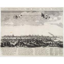
Constantinopolitanae urbis effigies ad vivum expressa.
Extremely rare panoramic view of Istanbul published by Rombout van den Hoeye. With a numbered key (1-29) to principal places in town and a Latin, Dutch, and French poem. ...
Date: Amsterdam, 1650
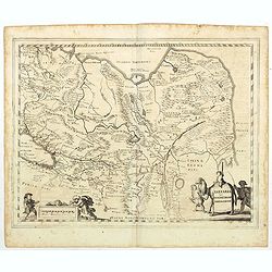
Tartaria sive Magnichami Imperiorum.
Stretching from the Caspian Sea in the west to the top of the island Korea . Decorated with finely engraved mountains and the Chinese wall.
- $175 / ≈ €151
Date: Frankfurt, 1650
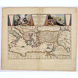
Descriptio Peregrinationis D. Pauli, Apostoli. . .
A striking map of the Mediterranean Sea and its surrounding areas. It depicts the travels of the Apostle St. Paul.The pair of decorative cartouches, presented in a curtai...
Date: Amsterdam, 1650
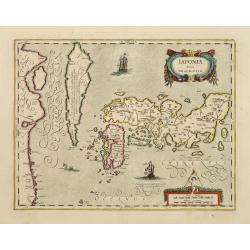
Japoniae Nova Descriptio.
The map is identical in cartographic detail to the Hondius map of 1606 but newly designed ornate cartouches have been added. The three main islands of Japan are shown wit...
Date: Amsterdam 1650
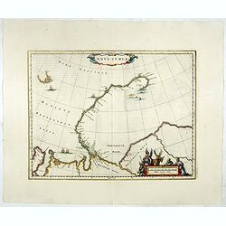
Nova Zemla.
Decorative sea chart decorated with hunters, polar foxes, polar bears and a sea monster.The scalebar in the lower right is in the form of a skewed 'checker-board', to ref...
- $900 / ≈ €779
Date: Amsterdam, 1650
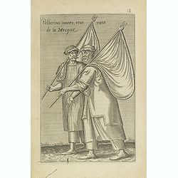
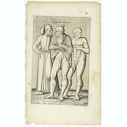
Pellerins mores, reue nuns de la Mecque.
Sought-after copper engraved plate from Laonikos Chalcocondyle’s "L'histoire de la décadence de l'empire grec et establissement de celuy des Turcs." by Thoma...
Date: Paris, Mathieu Guillemot, 1650
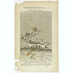
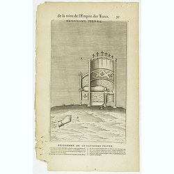
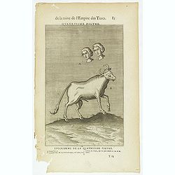
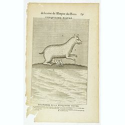
De la Ruine de l'Empire des Turcs Onziesme figure / Epigramme de la Onziesme figure. (99)
Sought-after copper engraved plate taken from Laonikos Chalcocondyle’s "L'histoire de la décadence de l'empire grec et establissement de celuy des Turcs", th...
- $25 / ≈ €22
Date: Paris, Mathieu Guillemot, 1650
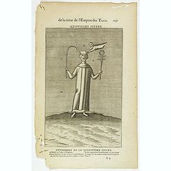
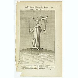
De la Ruine de l'Empire des Turcs Quinziesme figure / Epigramme de la Quinziesme figure. (107)
Sought-after copper engraved plate taken from Laonikos Chalcocondyle’s "L'histoire de la décadence de l'empire grec et establissement de celuy des Turcs", th...
- $25 / ≈ €22
Date: Paris, Mathieu Guillemot, 1650
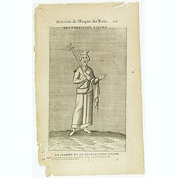
De la Ruine de l'Empire des Turcs Quatorziesme figure / Epigramme de la Quatorziesme figure. (105)
Sought-after copper engraved plate taken from Laonikos Chalcocondyle’s "L'histoire de la décadence de l'empire grec et establissement de celuy des Turcs", th...
- $25 / ≈ €22
Date: Paris, Mathieu Guillemot, 1650
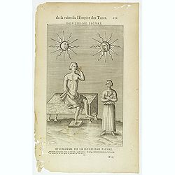
De la Ruine de l'Empire des Turcs Douziesme figure / Epigramme de la Douziesme figure. (101)
Sought-after copper engraved plate taken from Laonikos Chalcocondyle’s "L'histoire de la décadence de l'empire grec et establissement de celuy des Turcs", th...
- $25 / ≈ €22
Date: Paris, Mathieu Guillemot, 1650
Asie.
Map of Asia still showing Corey as an island. Including America's West Coast.More about Western mapping of Korea maps. [+]
- $500 / ≈ €433
Date: Paris, 1650
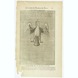
De la Ruine de l'Empire des Turcs Neufiesme figure / Epigramme de la Neufiesmie figure. (95)
Sought-after copper engraved plate taken from Laonikos Chalcocondyle’s "L'histoire de la décadence de l'empire grec et establissement de celuy des Turcs", th...
- $25 / ≈ €22
Date: Paris, Mathieu Guillemot, 1650
![[Four cartouche cuttings one sheet]](/uploads/cache/30307-250x250.jpg)
[Four cartouche cuttings one sheet]
Four cut-outs of scale cartouches from Johannes Janssonius plates. Cartouches featuring natives and merchants.
Date: Amsterdam, c.1650
Brabantia Ducatus.
West is at the top. On the lower left a magnificent cartouche with a sitting female figure carrying a globe and compasses and the coat of arms of Brabant. Like all other ...
- $500 / ≈ €433
Date: Amsterdam, 1650
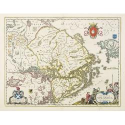
Ducatus Uplandia.
Covers the area of the modern Uppsala land in the vicinity of Stockholm, and includes most of Aland. With a Swedish coat of arms, a figural cartouche with rural people an...
Date: Amsterdam, 1650
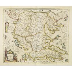
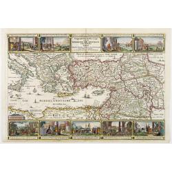
Macedonia, Epirus et Achaia.
Nice map of northern Greece with the southern parts of present day Macedonia and Albania. Includes the region of Athens. Strapwork title cartouche and Spanish text on ver...
Date: Amsterdam, 1650
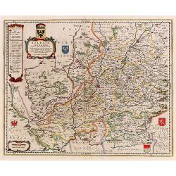
Silesia Inferior..
Decorative map prepared by Jonas Scultetus, a Silesian cartographer (1603-1664).
- $400 / ≈ €346
Date: Amsterdam, 1650
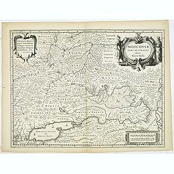
MOSCOVIAE Pars Australis. Auctore Isaaco Massa.
Very decorative map of the region north of the Sea of Azov. The map is based on the travels of Isaac Massa who visited Moscow in 1600 and thus was in the midst of the tur...
- $350 / ≈ €303
Date: Amsterdam, 1650
Estats de la Succession de Cleves/ Iuliers..
Fine map of western Germany.This edition carries the date 1650 and the publishers address A PARIS chez l'Autheur aux Galleries du Louvre. Nicolas Sanson was to bring abou...
Date: Paris 1650
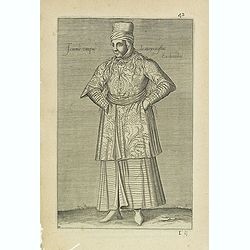
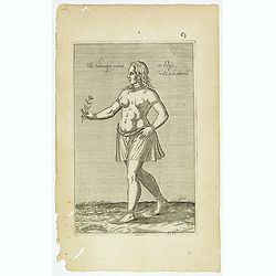
Femme Turque de moyen estat En chambre. (42)
Sought-after copper engraved plate from Laonikos Chalcocondyle’s "L'histoire de la décadence de l'empire grec et establissement de celuy des Turcs." by Thoma...
Date: Paris, Mathieu Guillemot, 1650
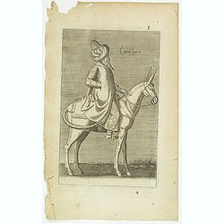
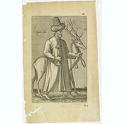
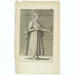
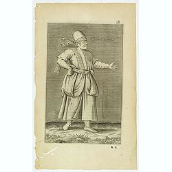
Calidesquer. (5)
Sought-after copper engraved plate from Laonikos Chalcocondyle’s "L'histoire de la décadence de l'empire grec et establissement de celuy des Turcs." by Thoma...
Date: Paris, Mathieu Guillemot, 1650
![[Title page] Theatrum orbis Terrarum sive Atlas Novus pars Tertia.](/uploads/cache/43695-250x250.jpg)
[Title page] Theatrum orbis Terrarum sive Atlas Novus pars Tertia.
Glorious mid-seventeenth century engraved frontispiece by Joan and Cornelis Blaeu from the third part of his 'Theatrum Orbis Terrarum'. Finely decorated with a pair of te...
- $350 / ≈ €303
Date: Amsterdam, 1650
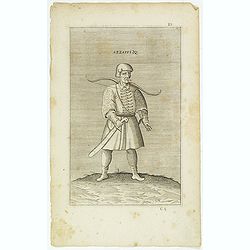
Azzappi. (10)
Sought-after copper engraved plate from Laonikos Chalcocondyle’s "L'histoire de la décadence de l'empire grec et establissement de celuy des Turcs." by Thoma...
- $50 / ≈ €43
Date: Paris, Mathieu Guillemot, 1650
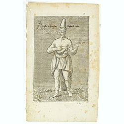
Azaoglan ou Iamoglan Enfant du tribut. (11)
Sought-after copper engraved plate taken from Laonikos Chalcocondyle’s "L'histoire de la décadence de l'empire grec et establissement de celuy des Turcs." by...
- $50 / ≈ €43
Date: Paris, Mathieu Guillemot, 1650
Russiae vulgo Moscovia pars australis. . .
Shows southern Russia from Crimea to 60 degrees north and from the Volga west to Smolensk. Centered on Moscow. Prepared by Isaac Massa, a Dutch mapmaker who traveled to R...
Date: Amsterdam, 1650
Pleuianders Luyteurs. (16)
Sought-after copper engraved plate taken from Laonikos Chalcocondyle’s "L'histoire de la décadence de l'empire grec et establissement de celuy des Turcs." by...
- $50 / ≈ €43
Date: Paris, Mathieu Guillemot, 1650
Delli de nation Parthique qui signifie Sol Harfy ou Enfant Perdu. (17)
Sought-after copper engraved plate taken from Laonikos Chalcocondyle’s "L'histoire de la décadence de l'empire grec et establissement de celuy des Turcs." by...
- $50 / ≈ €43
Date: Paris, Mathieu Guillemot, 1650
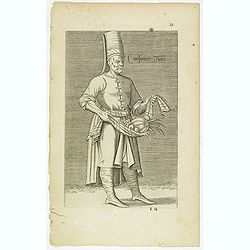
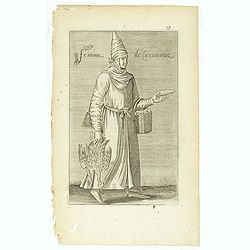
Cuisinier Turc. (19)
Sought-after copper engraved plate taken from Laonikos Chalcocondyle’s "L'histoire de la décadence de l'empire grec et establissement de celuy des Turcs." by...
Date: Paris, Mathieu Guillemot, 1650
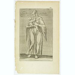
Religieux Turc. (26)
Sought-after copper engraved plate taken from Laonikos Chalcocondyle’s "L'histoire de la décadence de l'empire grec et establissement de celuy des Turcs." by...
Date: Paris, Mathieu Guillemot, 1650
Femme moresque de Tripoly en Barbarie. (60)
Sought-after copper engraved plate of a woman with child from Tripoli. Plate from Laonikos Chalcocondyle’s "L'histoire de la décadence de l'empire grec et establi...
- $45 / ≈ €39
Date: Paris, Mathieu Guillemot, 1650
Imperii Caroli Magni.
Wall map, prepared by Petrus Bertius in 1616. Extensive historical map (four sheets joined) depicting the empire of Charles the Great. Fully engraved with mountains, fore...
- $500 / ≈ €433
Date: Amsterdam, 1650
De la Ruine de l'Empire des Turcs Quatriesme figure / Epigramme de la Quatriesme figure. (85)
Sought-after copper engraved plate taken from Laonikos Chalcocondyle’s "L'histoire de la décadence de l'empire grec et establissement de celuy des Turcs", th...
- $50 / ≈ €43
Date: Paris, Mathieu Guillemot, 1650
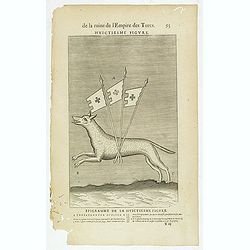
De la Ruine de l'Empire des Turcs Huictiesme figure / Epigramme de la Huictiesme figure. (93)
Sought-after copper engraved plate taken from Laonikos Chalcocondyle’s "L'histoire de la décadence de l'empire grec et establissement de celuy des Turcs", th...
- $50 / ≈ €43
Date: Paris, Mathieu Guillemot, 1650
De la Ruine de l'Empire des Turcs Seconde figure / Epigramme de la Seconde figure. (81)
Sought-after copper engraved plate taken from Laonikos Chalcocondyle’s "L'histoire de la décadence de l'empire grec et establissement de celuy des Turcs", th...
- $50 / ≈ €43
Date: Paris, Mathieu Guillemot, 1650
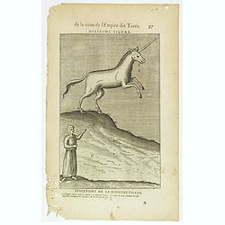
De la Ruine de l'Empire des Turcs Dixiesme figure / Epigramme de la Dixiesmie figure. (97)
Sought-after copper engraved plate taken from Laonikos Chalcocondyle’s "L'histoire de la décadence de l'empire grec et establissement de celuy des Turcs", th...
- $25 / ≈ €22
Date: Paris, Mathieu Guillemot, 1650
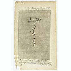
De la Ruine de l'Empire des Turcs Première figure / Epigramme de la première figure. (79)
Sought-after copper engraved plate taken from Laonikos Chalcocondyle’s "L'histoire de la décadence de l'empire grec et establissement de celuy des Turcs", th...
- $50 / ≈ €43
Date: Paris, Mathieu Guillemot, 1650
Fille Moresque esclave en Alger ville de Barbarie. (63)
Sought-after copper engraved plate of a young slave from Algeria. Plate from Laonikos Chalcocondyle’s "L'histoire de la décadence de l'empire grec et establisseme...
- $45 / ≈ €39
Date: Paris, Mathieu Guillemot, 1650
De la Ruine de l'Empire des Turcs Cinquiesme figure / Epigramme de la Cinquiesme figure. (87)
Sought-after copper engraved plate taken from Laonikos Chalcocondyle’s "L'histoire de la décadence de l'empire grec et establissement de celuy des Turcs", th...
- $50 / ≈ €43
Date: Paris, Mathieu Guillemot, 1650
Gentille Femme Perotte Franque. (48)
Sought-after copper engraved plate of a woman from Pera, taken from Laonikos Chalcocondyle’s "L'histoire de la décadence de l'empire grec et establissement de cel...
- $100 / ≈ €87
Date: Paris, Mathieu Guillemot, 1650
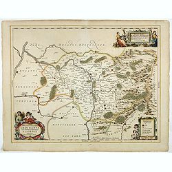
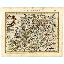
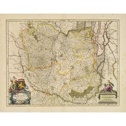
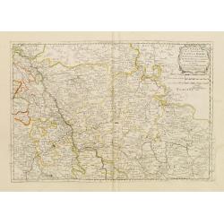
Ducatus Silesiae Grotganus cum Districtu Episcopali Nissensi Delineatore Iona Sculteto, Silesio.
Attractive engraved map of Upper Silesia prepared by Joanus Scultetus, a Silesian cartographer (1603-1664) and published by J. Janssonius. Showing the area around Nysa an...
- $400 / ≈ €346
Date: Amsterdam, 1650
Esclave More. (38)
Sought-after copper engraved plate of a Moor slave from North Africa. Plate from Laonikos Chalcocondyle’s "L'histoire de la décadence de l'empire grec et establis...
- $75 / ≈ €65
Date: Paris, Mathieu Guillemot, 1650
De la Ruine de l'Empire des Turcs Sixiesme figure / Epigramme de la Sixiesme figure. (89)
Sought-after copper engraved plate taken from Laonikos Chalcocondyle’s "L'histoire de la décadence de l'empire grec et establissement de celuy des Turcs", th...
- $50 / ≈ €43
Date: Paris, Mathieu Guillemot, 1650
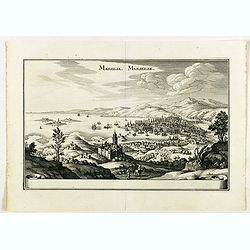
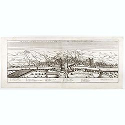
Massilia - Marseille.
Detailed bird's-eye view of the town of Marseille. From Merian's Theatrum Europaeum. To the bottom a lettered key to the principal places in town.
Date: Frankfurt 1650
Femme de la Caramanie. (57)
Sought-after copper engraved plate taken from Laonikos Chalcocondyle’s "L'histoire de la décadence de l'empire grec et establissement de celuy des Turcs." by...
- $50 / ≈ €43
Date: Paris, Mathieu Guillemot, 1650