Browse Listings
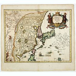
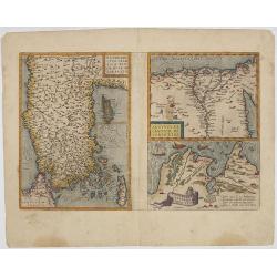
China Veteribus Sinarum Regio nunc Incolis Tame dicta.
Fine map of China, based on the first of Blaeu's maps of China. In the west by the Great Wall is shown, among Taiwan is named Pakan al I. Formosa, although Tayoan is name...
- $950 / ≈ €822
Date: Frankfurt am Main, 1638
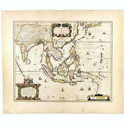
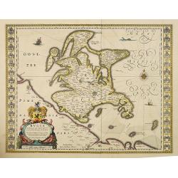
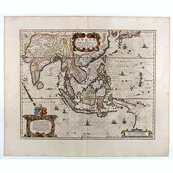
India quae Orientalis dicitur, et Insulae Adiacentes.
Map of South East Asia, noteworthy for being one of the first maps to include, albeit incompletely, the discoveries made by the Dutch vessel Duyfken in 1605-1606 in the G...
- $1750 / ≈ €1515
Date: Amsterdam, 1638
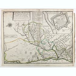
Carte du siège présidial Dax et seneschaucee des Lannes et des sieges de Bayonne sainct sever et Tartas qui en dependent Nouvellement dessignee Par le Sr de Classun.
Very rare map including Bayonne and Dax in the south west of France. With inset plan of "Plan de la ville Dax.". Engraved by Henri le Roy. With the address &quo...
Date: Paris, 1638
Osnabrugensis episcopatus.
A beautiful map of Munster centered on the city of Osnabruck. Prepared by Joannes Michael Gigas (1580-1650+), a doctor, mathematician and geographer. Showing an inset wit...
Date: Amsterdam, 1638
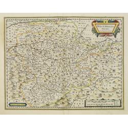
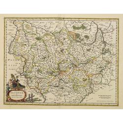
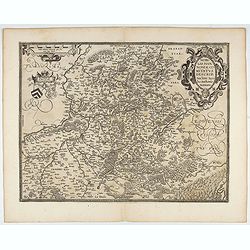
Westphalia Ducatus.
Elegantly engraved map of Westphalia including Hamm and Lippstadt. The mountainous topography is graphically depicted and several small coats of arms dot the map. Strapwo...
Date: Amsterdam, 1638
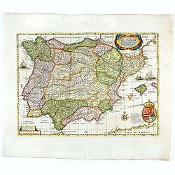
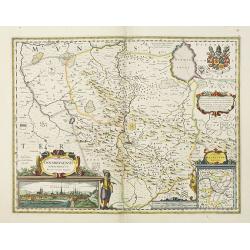
Typus Hispaniae ab Hesselo Gerardo delineata. . .
Decorative map of the kingdom of Spain and Portugal by Joan. Janssonius after the cartographic source by Hessel Gerard. Embellished by sailing ship, compass roses, and co...
Date: Amsterdam, 1638
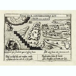
Malta maris medit.inf.
The representation of the town of Valletta on MaltaMeisner added in its center point a metaphorical representation of a medical doctor speaking out a baroque sentence of ...
- $400 / ≈ €346
Date: Frankfurt, 1638
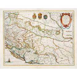
Sclavonia, Croatia cum Dalmatiae Parte.
Excellent map with coat-of-arms focusing specifically on the embattled nations of the former Yugoslavia.
Date: Amsterdam, 1638
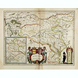
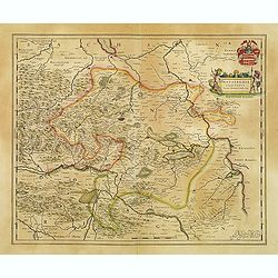
Comitatus Marchia et Ravensberg.
With an inset of Ravensberg comitatus. Decorative title cartouche with coats of arms. Scale cartouche with a surveyor.As Willem Blaeu died in 1638 most of his maps are ac...
- $80 / ≈ €69
Date: Amsterdam, 1638
Bravnswyck et Meydburg. . .
As Willem Blaeu died in 1638 most of his maps are actually published by his son Joan. This maps carries his (engraved) signature and was actually published in volume II o...
Date: Amsterdam, 1638
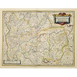
Monasteriensis Episcopatus.
A very detailed map of Germany centered on Munster and Linge. Also showing Wessel to the top of the map and Oldenburg to the right. North to the right. The map is adorned...
Date: Amsterdam, 1638
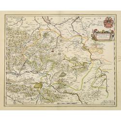
Mansfeldia Comitatus. . .
Centered on Mansfield and prepared by Telemann Stella (1527-1589) a German cartographer who made maps of Germany and the Holy Land.As Willem Blaeu died in 1638 most of hi...
Date: Amsterdam, 1638
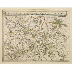
Saxonia Superior, cum Lusatia et Misnia.
Finely engraved and detailed map of Saxony including Halle, Leipzig, Meissen, and Dresden. Filled with forests and tiny villages. It presents Prague close to the centre o...
Date: Amsterdam, 1638
Rugia Insula ac ducatus. . .
Willem Blaeu's highly decorative map of the island of Rugen in the Baltic Sea from a map by Eihard Lubin. Embellished with a title-cartouches, and 30 coats-of-arms in the...
- $300 / ≈ €260
Date: Amsterdam, 1638
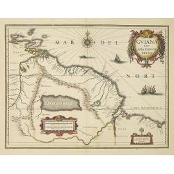
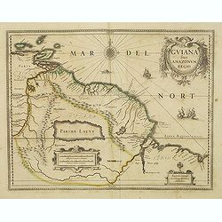
Guiana sive Amazonum Regio.
Willem Blaeu’s decorative map of the Guianas, Lake Parima (Parime Lacus), and the route to El Dorado was initially issued in 1630 (with some variants were published wel...
- $400 / ≈ €346
Date: Amsterdam, 1638
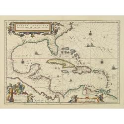
Insulae Americanae in Oceano Septentrionali cum Terris adiacentibus.
General map of the West Indies extending from Virginia to the mouth of the Orinoco, and destined to be copied in various shapes by many other publishers.Title cartouche t...
- $1800 / ≈ €1558
Date: Amsterdam, 1638
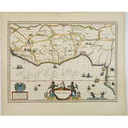
Guinea.
An attractive map covered with intersecting rhumb lines and decorated with monkeys, lions, elephants and native figures. With a dedication to Dr. Nicolas Tulp.As Willem B...
- $750 / ≈ €649
Date: Amsterdam, 1638
Tartaria sive Magni Chami imperium.
Detailed and decorative map of Tartary and Northern part of China. Northern tip of Korea included. The Chinese Great Wall is depicted, with Central Asia, extending from M...
- $500 / ≈ €433
Date: Amsterdam, 1638
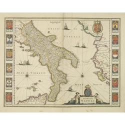
Regno di Napoli.
To the left and right 12 coats of arms of different regions.As Willem Blaeu died in 1638 most of his maps are actually published by his son Joan. This map was actually pu...
Date: Amsterdam, 1638
Mediolanum Ducatus.
Very fine map centered on Milan Including Lake Como, Lake Garda, Lake Majore, Parma, etc.As Willem Blaeu died in 1638 most of his maps are actually published by his son J...
Date: Amsterdam, 1638
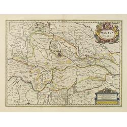
Mantua ducatus.
Centered at the town of Mantua.As Willem Blaeu died in 1638 most of his maps are actually published by his son Joan. This map carries his (engraved) signature and was act...
Date: Amsterdam, 1638
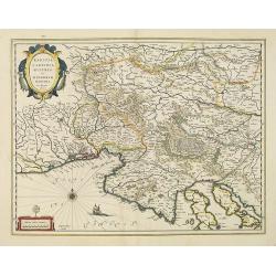
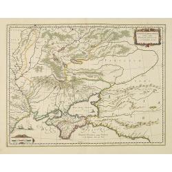
Karstia, Camiola, Histria et Windorum Marchia.
Including the Gulf of Trieste, Venice and the northern part of former Yugoslavia. Prepared by Gerard Mercator.As Willem Blaeu died in 1638 most of his maps are actually p...
Date: Amsterdam, 1638
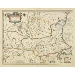
Walachia, Servia, Bulgaria, Romania.
Striking map of the region centered on the Lower Danube, Bulgaria, Romania, Serbia and Macedonia. Includes decorative cartouche, coat of arms, etc. Latin text on verso.Th...
Date: Amsterdam, 1638
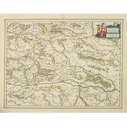
Stiria Steyermarck.
Covering the eastern part of Austria, Styria and Carinthia, centered on the town of Graz.As Willem Blaeu died in 1638 most of his maps are actually published by his son J...
Date: Amsterdam, 1638
Taurica Chersonesus, Nostra aetate Przecopsca, et Gazara dicitur.
Part of Russia with in the north Smolensk and Moscow and in the south the Black Sea.As Willem Blaeu died in 1638 most of his maps are actually published by his son Joan. ...
Date: Amsterdam, 1638
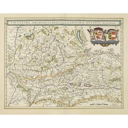
Saltzburg Archiepiscopatus, et Carinthia Ducatus
Handsome map of the archbishopric of Salzburg and the Duchy of Carinthia.Title in banner form with two coats of arms and three cherubs decorating the map.As Willem Blaeu ...
Date: Amsterdam, 1638
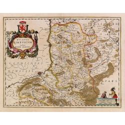
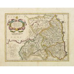
Ducatus Limburg.
In 1616 prepared by Aegidio Martini. Includes the towns of Maastricht as well as of Aachen. A very large title cartouche with two putti.
Date: Amsterdam 1639
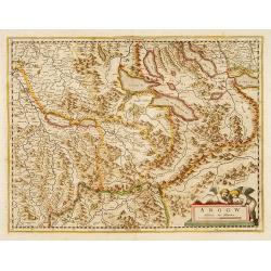
Argow .
Centered on the Bernese and Lucerne. Including the towns of Lucerne, Bern and Thuner- and Lucerner See. Prepared by Gerard Mercator.
Date: Amsterdam, 1639
![[Title page] Theatri Europaei, oder historischer chronicken Beschreibung . . .](/uploads/cache/41394-250x250.jpg)
[Title page] Theatri Europaei, oder historischer chronicken Beschreibung . . .
Title page, lavishly decorated with in the middle Fama who blows trumpets on a fortress tower, with another trumpet held in the other hand. Fama can proclaim war glory, b...
- $100 / ≈ €87
Date: Frankfurt, ca. 1639
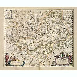
Comitatus Glatz.
Handsome map of the Silesia region with Glatz (Klodzko) at center. The forested region was renowned for its wild game and the map includes tiny illustrations of the wildl...
- $450 / ≈ €389
Date: Amsterdam, 1640
Carte de l'Amérique, corrigée et augmentée…1640.
State 2. Re-edition of the map by Bertius of 1624, the name of Bertius removed and dated 1640. Inset maps of the Arctic and Antarctic. The map is based on the Jodocus Hon...
Date: Amsterdam, 1640
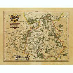
Waldeck Comitatus.
Map centered on Waldeck, Korbach, etc.
- $100 / ≈ €87
Date: Amsterdam, 1640
![[Title page from] Le Theatre du Monde ou Nouvel Atlas.](/uploads/cache/06754-250x250.jpg)
[Title page from] Le Theatre du Monde ou Nouvel Atlas.
Architectural frontage without the usual title and imprint printed on paste-on slips.More about title pages [+]
- $250 / ≈ €216
Date: Amsterdam, 1640
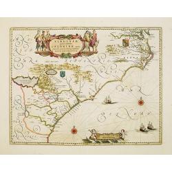
Virginiae Partis Australis, et Floridae Partis Orientalis.
Blaeu based this map on the Mercator-Hondius of 1606. A number of geographical improvements, however were incorporated, although two large fictions lakes accompanied by e...
- $1400 / ≈ €1212
Date: Amsterdam, 1640
Guiana sive Amazonum Regio.
Nice map extending from the Isla Margarita in the northwest to the coast of northern Brazil near Sao Luis east of the Amazon delta. The map locates at its center a large ...
- $500 / ≈ €433
Date: Amsterdam, 1640
![[Title page] Theatrum orbis Terrarum sive Atlas Novus pars Secunda.](/uploads/cache/47922-250x250.jpg)
[Title page] Theatrum orbis Terrarum sive Atlas Novus pars Secunda.
Glorious mid-seventeenth century engraved frontispiece by Joan and Cornelis Blaeu from the second part of his 'Theatrum Orbis Terrarum'.Read more about decorative atlas ...
- $350 / ≈ €303
Date: Amsterdam, 1640
India quae Orientalis dicitur, et Insulae adiacentes.
A fine map of South East Asia, extending from India to Tibet to Japan to New Guinea. Formosa appears on this map, and even parts of Japan and Australia are seen. A handso...
- $1850 / ≈ €1601
Date: Amsterdam, 1640

Asia secunda pars terrae in forma Pegasi.
Asia is depicted as the flying horse Pegasus. This cartographical curiosity, double-page copper engraved map, was published in Heinrich Bünting's “Itinerarium Sacrae S...
Date: Brunswick, 1640
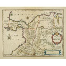
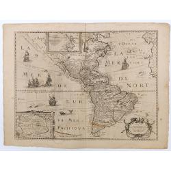
Terra Firma et Novum regnum Granatense et Propayan.
Fine copy, with wide margins of this handsome map of the Isthmus of Panama and northwestern South America including most of present day Columbia and part of Venezuela. Te...
- $400 / ≈ €346
Date: Amsterdam, 1640
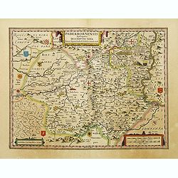
Paderbornensis Episscopatus Descriptio Nova.
Detailed map by Willem Blaeu., centered on Paderborn. Embellished with several coats of arms. Prepared by Joannes Michael Gigas (1580-1650+), a doctor, mathematician and ...
- $175 / ≈ €151
Date: Amsterdam, 1640
Mansfeldia Comitatus..
Centered on Mansfeld and prepared by Tilemano Stella (1527-1589) a German cartographer who made maps of Germany and the Holy Land.
- $100 / ≈ €87
Date: Amsterdam, 1640
Guinea.
An attractive map covered with intersecting rhumb lines and decorated with monkeys, lions, elephants and native figures. A coat of arms and a dedicatory cartouche in the...
Date: Amsterdam, 1640
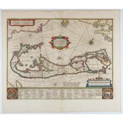
Mappa Aestivarum Insularum, alias Barmudas...
This magnificent map is based on the famous survey by John Norwood of the Bermuda Company in 1618. The map shows the division into the original Tribes and shows the vario...
- $1700 / ≈ €1471
Date: Amsterdam, 1640

Venezuela cum parte Australi novae Andalusiae.
RARE. A finely engraved, decorative map with no text on the verso. The islands Trinidad, Margarita, Aruba and Curaçao are shown as well.
Date: Amsterdam, c. 1640
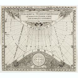
N°2. Horologium Horizontale Paralle los Horizontis cum Hor: a meridie numeratis ostendens.
This beautiful engraving is a horological diagram with at bottom a 32-point wind rose and signed underneath "Franciscus Ritter N fac:".Remarkable for the elabor...
- $750 / ≈ €649
Date: Nuremberg 1640
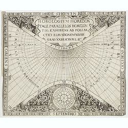
N°5. Horologium Horizontale signa zodiaci ascendentia : ec.cotinens ad latitud XLVIIII : GR: XXIIII: SCR ee.
This beautiful engraving is a horological diagram with at bottom a 32-point wind rose and signed underneath "M:Franciscus Ritter N fac A° 1640".Remarkable for ...
- $400 / ≈ €346
Date: Nuremberg 1640
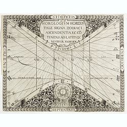
N°7. Horologium Horizontale parallelos Horizontis Exhibens ad Poliarctici elevationem XLVIIII Grad XXIIII Scrupul Ec.
This beautiful engraving is a horological diagram with at bottom a 32-point wind rose and signed underneath "M:Franciscus Ritter N fac A° 1640".Remarkable for ...
- $750 / ≈ €649
Date: Nuremberg 1640
![[Horological diagrams surrounding a smaller world map]](/uploads/cache/45027-250x250.jpg)
[Horological diagrams surrounding a smaller world map]
This beautiful engraving has nine (of ten) horological diagrams surrounding a smaller map, which omits any delineation of the British Isles. Projected from the North Pole...
- $2000 / ≈ €1731
Date: Nuremberg 1640
![[Title page] Le Theatre du Monde ou Nouvel Atlas . . .](/uploads/cache/27212-250x250.jpg)
[Title page] Le Theatre du Monde ou Nouvel Atlas . . .
Architectural frontage with the title and imprint printed on paste-on slips decorated by a heraldic shield, with crown and garters.
- $200 / ≈ €173
Date: Amsterdam, 1640
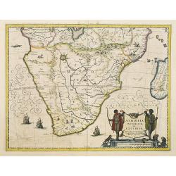
Aethiopia Inferior vel Exterior.
The standard map of South Africa throughout the 17th century. The lake out of which the 'Zambere' -the Zambesi- flows is probably based on reports of Lake Ngami, undiscov...
- $750 / ≈ €649
Date: Amsterdam, 1640
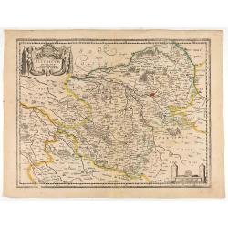
Bituricum Ducatus. Duche de Berri.
A very decorative map with beautiful cartouches of a province of France by one of the most famous map publishers. Berry is a region located in the center of France. It wa...
Date: Amsterdam, 1640

Carte de l'Asie, corrigée et augmentée, dessus toutes les aultres Faict L année 1640.
Map of Asia with a dedication to Pierre Petit. The map bears a very close resemblance to the Asia maps of the Hondius family. Michael Van Lochom (1601-1647) was a Calvini...
Date: [Paris], 1640
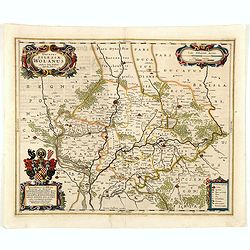
Ducatus silasiae Wolanus. . .
An engraved 17th-century map of the Duchy of Wohlau in Poland with four cartouches in the corners. Orientated with east at the top. The decorative cartouche displaying th...
- $550 / ≈ €476
Date: Amsterdam, ca. 1641
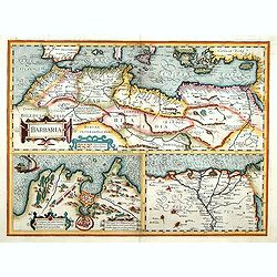
Barbaria. / Egypt / Tunesia.
Three maps on one sheet. Upper part, it shows the coast of Barbaria from Morocco to Egypt: the map on the left corner of Tunis includes a plan of Goletiae, and the right ...
- $300 / ≈ €260
Date: Amsterdam, 1641
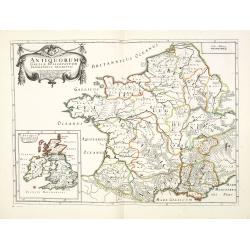
Antiquorum Galliae episcopatuum geographica descriptio. . . / Antiqui magnae Britaniae Episcopatus.
Detailed map of France during Ancient times. In lower left corner inset map of England "Antiqui magnae Britaniae Episcopatus." (160x146mm.) First published in &...
Date: Paris, ca.1641
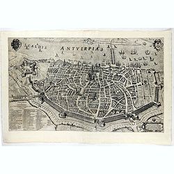
Scaldis Antverpia - Locorum Insignium ac viae triumphalis qua ser.mus princeps, Ferdinandus Austriacus, Hispaniar, Infans. etc. Antverpiam est ingressus, designatio . . .
Bird's-eye view of the city of Antwerp and the River Schelde, numbered (1-59 ) with important sites along the entry of the Cardinal Infant Ferdinand of Austria into Antwe...
- $2000 / ≈ €1731
Date: Antwerp, 1635-1641
Natoliae.. Aegypti recentior.. Carthaginis (3 maps on 1 sheet)
Map to the left east to the top. Detailed map Turkey, including Cyprus and Crete. Also map of the Nile delta and another map of Tunis. From "Theatrum Orbis Terrarum&...
Date: Antwerp, 1609-1641
![[Title page] Le Nouveau Theatre du Monde Nouvel Atlas Tome Troisieme.](/uploads/cache/47946-250x250.jpg)
[Title page] Le Nouveau Theatre du Monde Nouvel Atlas Tome Troisieme.
A very attractive title page from Le Nouveau Theatre du Monde Nouvel Atlas Tome Troisieme. .
Date: Amsterdam, 1641
Nobilis Hannoniae Comitatus Descrip.
Fine map of Hannonia (Hainaut), with ornate cartouches, two coats of arms, etc. Showing the cities of Charleroi, Mons, Ath, Tournay, Valenciennes, Maubeuge, etc. in Belgi...
- $600 / ≈ €519
Date: Antwerp, 1612-1641
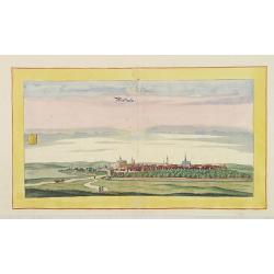
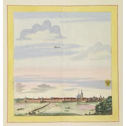
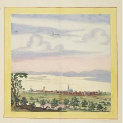
Newstatt an der Orla.
Very decorative and rare panoramic of Neustadt a.d. Donau, Kr. Kelheim, Ndb.The engraver and publisher of prints, Mrs. Anna Beek of the Hague, enlarged the print and mou...
Date: The Hague, ca. 1642
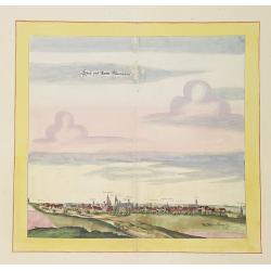
Hertzberg.
Very decorative and rare panoramic town view of Herzberg a.d. Schwarzen Elster, Bez. Cootbus.The engraver and publisher of prints, Mrs. Anna Beek of the Hague, enlarged t...
Date: The Hague, ca. 1642
Weissensee.
Very decorative and rare panoramic town view of Weissensee in Thürigen, Bez. Erfurt.The engraver and publisher of prints, Mrs. Anna Beek of the Hague, enlarged the print...
Date: The Hague, ca. 1642
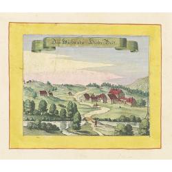
Das Wiesen oder Hiobs Badt.
Very decorative and rare panoramic town view of Wiensenbad near Annaberg im Erzgebirge.The engraver and publisher of prints, Mrs. Anna Beek of the Hague, enlarged the pri...
Date: The Hague, ca. 1642
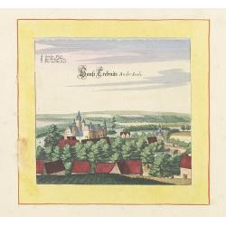
Haus trebnits an der saale.
Very decorative and rare panoramic of Trebnitz a.d Saale , Bez. Halle.The engraver and publisher of prints, Mrs. Anna Beek of the Hague, enlarged the print and mounted i...
Date: The Hague, ca. 1642

Greüssen.
Very decorative and rare panoramic town view of Greussen (Thür.),Bez. Erfurt .The engraver and publisher of prints, Mrs. Anna Beek of the Hague, enlarged the print and m...
Date: The Hague, ca. 1642
Schweet.
Very decorative and rare panoramic town view of Schwedt a.d Oder, Bez. Frankfurt a.d. Oder.The engraver and publisher of prints, Mrs. Anna Beek of the Hague, enlarged the...
Date: The Hague, ca. 1642
Northumbria, Cumberlandia et Dunelmensis Episcopatus..
Showing the most northern part of England, including Sunderland.
- $400 / ≈ €346
Date: Amsterdam, 1642
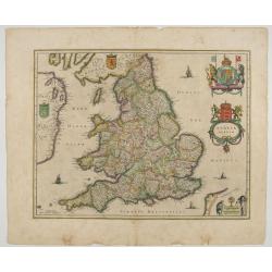
Anglia Regnum.
Janssonius' map of England and Wales was one of the new maps prepared by him in 1636. His map closely copies the similar map issued two years earlier by Willem Blaeu.. Th...
Date: Amsterdam, 1642
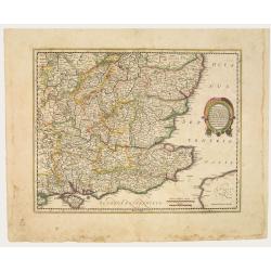
Warwicum Northamtonia Huntingdonia Cantabrigia..
Showing the south-eastern part of England.
Date: Amsterdam, 1642
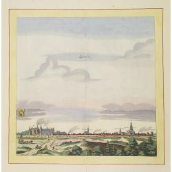
Werben.
Very decorative and rare panoramic town view of Werben a.d. Elbe, Bez. Magdeburg.The engraver and publisher of prints, Mrs. Anna Beek of the Hague, enlarged the print and...
Date: The Hague, ca. 1642
Bützom.
Very decorative and rare panoramic town view of Bützom.The engraver and publisher of prints, Mrs. Anna Beek of the Hague, enlarged the print and mounted it on larger pap...
Date: The Hague, ca. 1642
Statt und Ambtt Wantzleben.
Very decorative and rare panoramic town view of Wanzleben, Bez. Magdeburg.The engraver and publisher of prints, Mrs. Anna Beek of the Hague, enlarged the print and mounte...
Date: The Hague, ca. 1642
![[Title page] Provincia di Bertagna.](/uploads/cache/48049-250x250.jpg)
[Title page] Provincia di Bertagna.
Title page by Tassin.
Date: Paris, 1643
![[Title page] Figura di tutta la francia.](/uploads/cache/48046-250x250.jpg)
[Title page] Figura di tutta la francia.
Title page by Tassin.
Date: Paris, 1643
-250x250.jpg)
Helvetia cum finitimis regionibus confoederatis.
A typically detailed and finely engraved map of Switzerland by Blaeu, including the cities of Basel, Zürich, Bern, Lucerne, Fribourg, etc. The map is embellished with tw...
Date: Amsterdam, 1643
Title page : Topographia Sueviae dasist . . .
Title page from Casper Merian's Topographia Suevia..
- $50 / ≈ €43
Date: Frankfurt, 1643
![[Title page] Figura Universale](/uploads/cache/48045-250x250.jpg)
[Title page] Figura Universale
Title page by N.Tassin.
Date: Paris, 1643
![[Title page] Provincia di Bertagna.](/uploads/cache/48042-250x250.jpg)
[Title page] Provincia di Bertagna.
Title page by N. Tassin.
Date: Paris, 1643
(Title page) Topographia Sueviae dasist . . .
Title page from Casper Merian's Topographia Sueviae. . ..
- $50 / ≈ €43
Date: Frankfurt, 1643
![[Title page] Provincia di Bertagna.](/uploads/cache/48043-250x250.jpg)
[Title page] Provincia di Bertagna.
Title page by N.Tassin.
Date: Paris, 1643