Browse Listings
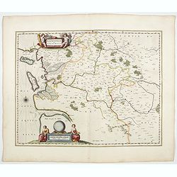
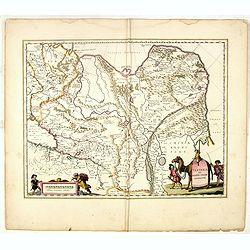
Xaintonge et Angoumois.
This map features a portion of western coastal France, north of Bordeaux with Ile de Ré and Ile Oléron. Two large cartouches show cherubs with grapes and wheat, and tw...
- $450 / ≈ €389
Date: Amsterdam, 1644
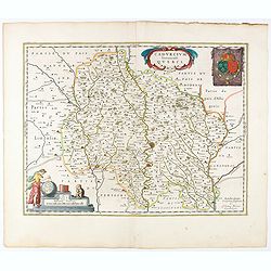
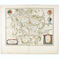
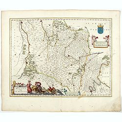
Cadurcium Vernaculé Querci.
Detailed map of a province of France by one of the most famous map publisher. Centered on Cahors.In the lower-left corner, a colored scale cartouche surmounted by a monke...
Date: Amsterdam, 1644
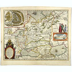
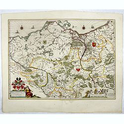
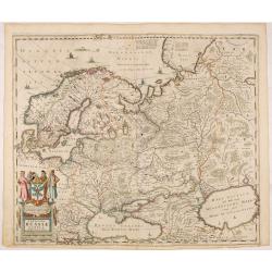
Tabula Russiae.
A re-issue, by Willem Blaeu, of Hessel Gerritsz' rare and influential map of Russia.This fine map was compiled from manuscripts brought back from Russia, by Isaac Massa, ...
Date: Amsterdam, 1644

Europa recens descripta à Guilielmo Blaeuw.
On either side, columns depicting the manner of dress in the major countries of Europe, surmounted by nine city views and plans.For European mapmakers their own continent...
Date: Amsterdam, 1644
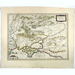
Taurica Chersonesus, Nostra aetate Przecopsca, et Gazara dicitur.
Part of Russia with in the north Smolensk and Moscow and in the south the Black Sea. More about Willem Blaeu. [+]
- $300 / ≈ €260
Date: Amsterdam, 1644
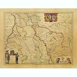
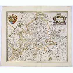
Ducatus Silesiae Glogani Vera Delineatio . . .
Map of Silesia showing the area of Glogow. French text on back. More about Willem Blaeu. [+]
- $350 / ≈ €303
Date: Amsterdam, 1644
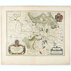
Picardia Regio Belgica.
Map of the northern region of Picardy. The region is well known due to the 4 major battles fought between France, Britain and Germany between 1915-18 during World War I. ...
- $400 / ≈ €346
Date: Amsterdam, 1644
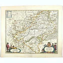
Veromanduorum.. Vermandois / Gouvernement de la Capelle.
A very decorative map with beautiful cartouches of a province of France by one of the most famous map publishers. Signed by Guilielmus Blaeu.From early on Willem Jansz. B...
- $220 / ≈ €190
Date: Amsterdam, 1644
Comitatus Glatz.
Nice map by Willem Blaeu of the Silesia region with Glatz (Klodzko) at center. The forested region was renowned for its wild game and the map includes tiny illustrations ...
- $450 / ≈ €389
Date: Amsterdam, 1644
Les Souverainetez de Sedan et de Raucourt.. Doncheri.
A very decorative map with beautiful large cartouches of a province of France by one of the most famous map publishers. From early on Willem Jansz. Blaeu aimed of publis...
- $175 / ≈ €151
Date: Amsterdam, 1644
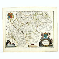
Le Gouvernement de l'Isle de France.
A very detailed map of Ile de France centered on Paris. Showing Beauvais, Compiègne, Noyon, Laon, Soisson, Vernon, Mante, Pontoise, Meaux, etc.Adorned with the royal arm...
- $300 / ≈ €260
Date: Amsterdam, 1644
Brandeburgum Marchionatus. . .
Decorative map by Willem Blaeu centered on Berlin and Brandenburg, and part of Poland and Pomerania, Mecklenburg and Rugia with excellent detail of forests, rivers, towns...
- $250 / ≈ €216
Date: Amsterdam, 1644
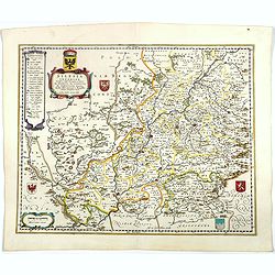
Territorium Metense. Auctore Ab. Fabert.. Le Pais Messin.
A very decorative map of part of Lorraine with beautiful cartouches. Orientated with West on top. Centered on Metz. From early on Willem Jansz. Blaeu aimed of publishing...
- $300 / ≈ €260
Date: Amsterdam, 1644
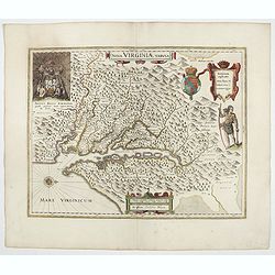
Nova Virginiae Tabula.
The map is based on the first state of Smith's map, 1612, and is slightly larger and more expertly engraved. In 1629 the Hondius plate was purchased by Blaeu who deleted ...
Date: Amsterdam, 1644
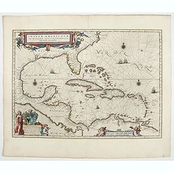
Insulae Americanae in Oceanus Septentrionali cum Terris..
General map of the West Indies extending from Virginia to the mouth of the Orinoco, and destined to be copied in various shapes by many other publishers.Title cartouche t...
- $2500 / ≈ €2164
Date: Amsterdam, 1644

Americae Nova Tabula.
An inset shows Greenland and Iceland. Decorative elements include ships, sea monsters, and vignettes of native Americans within South America. In addition, the map is bor...
- $6500 / ≈ €5625
Date: Amsterdam, 1644
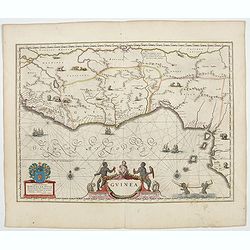
Guinea.
An attractive map covered with intersecting rhumb lines and decorated with monkeys, lions, elephants and native figures. With a dedication to Amsterdam anatomist and phys...
- $750 / ≈ €649
Date: Amsterdam, 1644
Silesia Inferior. . .
Decorative map prepared by Jonas Scultetus, a Silesian cartographer (1603-1664). More about Willem Blaeu. [+]
- $300 / ≈ €260
Date: Amsterdam, 1644
![[Title page ] Duo Pro-regit Vnus.](/uploads/cache/47930-250x250.jpg)
[Title page ] Duo Pro-regit Vnus.
Blank frontispiece of Blaeu.More about Willem & Joan Blaeu and decorative atlas title pages [+]
- $300 / ≈ €260
Date: Amsterdam, 1644
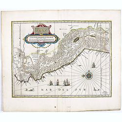
Peru.
FIRST EDITION, FIRST ISSUE OF THIS MAP. Decorated with ships and monsters in the sea. Orientated with east at the top. With the signature of G. Blaeuw lower right corner....
- $900 / ≈ €779
Date: Amsterdam, 1644
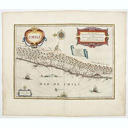
Chili.
Willem Blaeu's very decorative map of Chili with two large and beautiful cartouches, a compass and ships. From early on Willem Jansz. Blaeu aimed of publishing an atlas ...
- $900 / ≈ €779
Date: Amsterdam, 1644
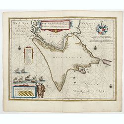
Tabula Magellanica.
A map with Willem Blaeu's signature, but published by his son Joan, of South America's extremity. A dedication to Constantijn Huygens. From early on Willem Jansz. Blaeu ...
- $1000 / ≈ €865
Date: Amsterdam, 1644
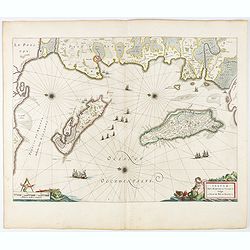
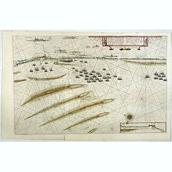
Insulae Divi Martini et Uliarus, vulgo L'Isle de Ré.. Oleron.
Map of Ré and Oléron islands. Depicting the west coast of France, showing La Rochelle. Several vessels and sailing ships dot the Atlantic ocean.Three windroses indicate...
- $950 / ≈ €822
Date: Amsterdam, 1644
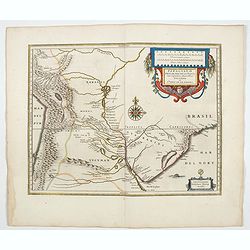
Paraguayo prov. de Rio de La Plata cum regionibus..
A beautiful map of Paraguay, and parts of Peru, Chile, Argentina, Brazil and Bolivia. Much of the area was still "Terra Incognita" so there are few towns and ci...
- $600 / ≈ €519
Date: Amsterdam, 1644
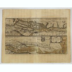
Celeberrimi Fluvis Albis nova delineatio. . .
A decorative map from a 1640's Latin text edition of Blaeu's "Theatrum Orbis Terrarum, Sive Atlas Novis." The River Elbe is depicted in two sections from the mo...
- $80 / ≈ €69
Date: Amsterdam, 1644
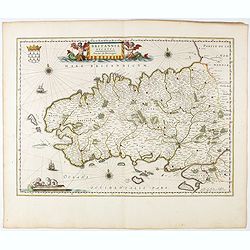
Britannia Ducatus. Duché de Bretaigne.
Map of Bretagne in France. From early on Willem Jansz. Blaeu aimed of publishing an atlas to compete with the Hondius-Jansson Atlas. By 1630, he had published at least 1...
- $650 / ≈ €563
Date: Amsterdam, 1644
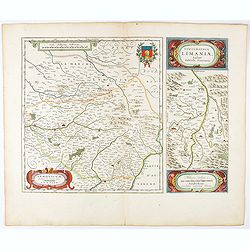
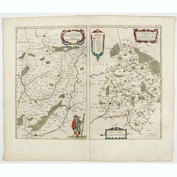
Lemovicum.. Lymosin. / Topographia Limaniae. . .
Two maps on one sheet. The author of the map of Lymosin was the French physician and cartographer Jean du Fayen. From early on Willem Jansz. Blaeu aimed of publishing an...
- $175 / ≈ €151
Date: Amsterdam, 1644
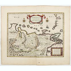
Venezuela cum parte Australi Novae Andalusiae.
A finely engraved, decorative map of Venezuela. The islands of Trinidad and Tobago, Margarita, Aruba and Curaçao are shown. Local animals are depicted, sheep, birds, mon...
- $800 / ≈ €692
Date: Amsterdam, ca. 1644
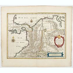
Terra Firma et Novum regnum Granatense et Propayan.
Handsome map of the Isthmus of Panama and north-western South America, including most of present day Columbia and part of Venezuela.Terra Firma is Panama, Veragua is Cost...
- $350 / ≈ €303
Date: Amsterdam, ca. 1644
Belsia vulgo La Beausse.
In the left-hand lower part of the image a beautiful contemporary cartouche with goddess Ceres [agricultural] holding a reaping-hook in her right hand and receiving with ...
- $200 / ≈ €173
Date: Amsterdam , 1644
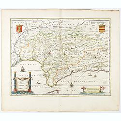
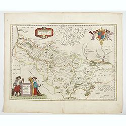
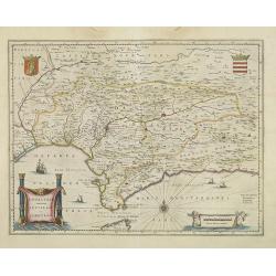
Andaluzia continens Sevillam.
Features the province of Andalucia and the city of Seville, but also depicts the Straights of Gibraltar, know in classical times as the Pillars of Hercules. Córdoba, Má...
- $350 / ≈ €303
Date: Amsterdam, 1644
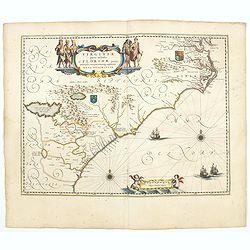
Virginiae Partis Australis, et Floridae Partis Orientalis.
Blaeu based this map on the Mercator-Hondius of 1606. A number of geographical improvements, however were incorporated, although two large fictions lakes accompanied by e...
- $1500 / ≈ €1298
Date: Amsterdam, 1644
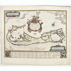
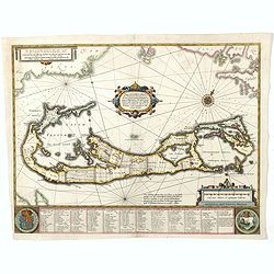
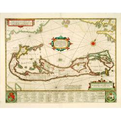
Mappa Aestivarum Insularum alias Barmudas.
Blaeu based his work on John Speed's remarkably accurate map of 1626-1627. It shows the island divided into tribes and lots, and below the map itself appear the names of ...
- $2000 / ≈ €1731
Date: Amsterdam, 1644
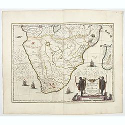
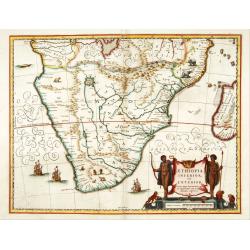
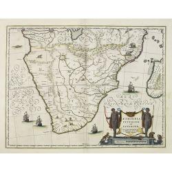
Aethiopia inferior, vel exterior.
The standard map of South Africa throughout the 17th century. The lake out of which the 'Zambere' -the Zambesi- flows is probably based on reports of Lake Ngami, undiscov...
- $1100 / ≈ €952
Date: Amsterdam, 1644
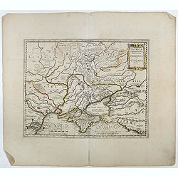
Taurica Chersonesus.
One of the earliest detailed maps of the Crimea and Ukraine between the northern coast of the Black Sea and Moscow.With the engraved signature of Gerard Mercator in lower...
- $300 / ≈ €260
Date: Amsterdam, 1639-1644
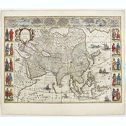
Asia noviter delineata. . .
From 1633 the members of the Blaeu family were official cartographers to the United East India Company and, as such, had access to the most up-to-date cartographic inform...
Date: Amsterdam, 1644
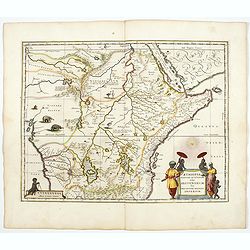
Aethiopia Superior vel Interior vulgo Abissinorum.
An attractive map of Eastern Africa and the fictitious kingdom of Prester John. The map shows a significant section of central and eastern Africa, including Mozambique, n...
- $700 / ≈ €606
Date: Amsterdam, 1644
Fezzae et Marocchi regna Africae celeberrima.
North to the right. Showing the Atlas Mountains in the south to the southern coast of Spain, along the coast at Ceuta, Tangiers, and Arzilla.A finely engraved, decorative...
- $500 / ≈ €433
Date: Amsterdam, 1644
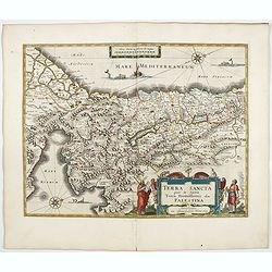
TERRA SANCTA quae in Sacris Terra Promissionis...
The Holy Land, Promised Land or Palestine. Oriented to the west. Shows the entire Palestine on both sides of the Jordan, the shore line running from Tripoli as far as the...
- $1000 / ≈ €865
Date: Amsterdam, 1644
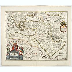
Turcicum Imperium.
A very handsome map with a particularly fine cartouche showing the Turkish Sultan on his throne and allegorical figures at either side brandishing weapons. At the right i...
- $1800 / ≈ €1558
Date: Amsterdam, 1644
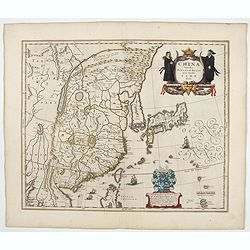
China Veteribus Sinarum Regio.
This was the first of Blaeu's maps of China. In 1655 he was to publish the famous map of Father Martini, with many of the earlier inaccuracies present on this map correct...
- $2200 / ≈ €1904
Date: Amsterdam, 1644
Magni Mogolis Imperium.
An attractive map of the region from Iran through Afghanistan, Tibet, and northern India across to Burma. The travel route from Kabul to Surat is the most prominent featu...
- $350 / ≈ €303
Date: Amsterdam, 1644
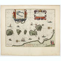
Moluccae Insulae Celeberrimae.
Showing the geographical features of the islands, and decorated with ships, sea monsters and a handsome cartouche. With an inset of Bachian island. From early on Willem ...
- $750 / ≈ €649
Date: Amsterdam, 1644
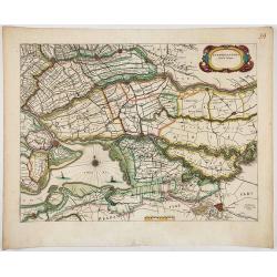
Afbeeldinge vande vermaerde seehaven .. Duynkerken..
Blaeu's map of the coast of the French coast from Duinkerk till Waldamme. In an inset, lower right the continuation till Calais. Many ships offshore Duinkerk, with soundi...
- $500 / ≈ €433
Date: Amsterdam, 1645
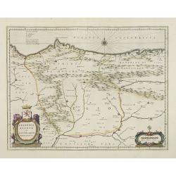
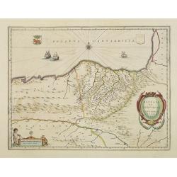
Legionis Regnum et Asturiarum Principatus.
A very decorative map by Willem Blaeu of the Spanish Province Asturias, Castile and Léon, including the towns of Oviedo, Leon, Santander, Valladolid, etc. With two fine ...
Date: Amsterdam, 1645
Andalusia continens Sevillam et Cordubam.
Features the province of Andalusia and the city of Seville, but also depicts the Straights of Gibraltar, know in classical times as the Pillars of Hercules. The title car...
Date: Amsterdam, 1645
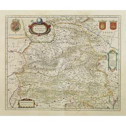
Utriusque Castillae nova descriptio.
Blaeu's map of León-Castilla, showing Zaragoza, Valencia, Alicante, Cartagena, Madrid, Cordoba, Seville, Salamanca, Palencia, Segovia, Toledo, Cuenca, Granada, etc. Incl...
Date: Amsterdam, 1645
Biscaia et Guipuscoa Cantabriae veteris Pars.
Shows cities of Bilbao and Laredo, and includes a charming vignette of a putti with surveying equipment, being observed by a kitten. With Dutch text on verso.More about m...
Date: Amsterdam, 1645
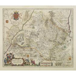
Navarra Regnum.
Decorative map of the region which includes the city of Pamplona at the centre of the map, Bayonne and San Sebastian. Highly decorative figured cartouche bottom left. Fou...
Date: Amsterdam, 1645
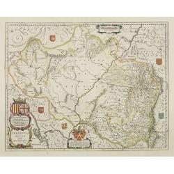
Arragonia Regnum.
A beautiful, highly decorative map of Aragon, centered on Saragossa and extending to Balbasdtor, Huesca, Calataiud, Tortosa, Tervel, Albarrazin and Cuenca. Towns, rivers,...
Date: Amsterdam, 1645
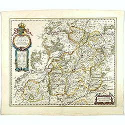
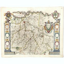
Archiepiscopatus Maghdeburgensis et Anhaltinus Ducatus.
A very nice, decorative copper engraved map of Lower-Saxony and Saxony-Anhalt by Blaeu. With one figural cartouche. Bounded on the west by the River Wesel between Nienbur...
- $80 / ≈ €69
Date: Amsterdam, 1645
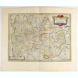
Monasteriensis Episcopatus.
A very detailed map of Germany centered on Linge. Showing Wessel to the top of the map, and Oldenburg to the right. North is oriented to the right. The map is further ado...
- $80 / ≈ €69
Date: Amsterdam 1645
Quarta pars Brabantiae cujus caput Sylvaducis.
The coat of arms of Brabant and 's-Hertogenbosch do appear on the map. But the municipal arms in the columns on right and left-hand side have not yet been filled in. The ...
Date: Amsterdam, 1645
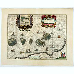
Moluccae Insulae Celeberrimae.
Showing the geographical features of the islands and decorated with ships, sea monsters and a handsome cartouche. With an inset of Bachian island. From early on Willem J...
- $750 / ≈ €649
Date: Amsterdam, ca.1645
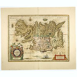
Tabula Islandiae..
This handsome map of Iceland was based on information from a Dutch navigator named Joris Carolus in about 1620. The map shows the influence of both versions of bishop Gud...
- $1100 / ≈ €952
Date: Amsterdam, 1645
Tartaria sive Magni Chami Imperium.
Detailed and decorative map of Tartary and Northern part of China. Northern tip of Korea included. The Chinese Great Wall is depicted, with Central Asia, extending from M...
- $550 / ≈ €476
Date: Amsterdam, 1645
Mappa Aestivarum Insularum, alias Barmudas..
Based closely on Blaeu's map of 1630 but with a simpler centered title piece. The map includes the arms of Bermuda and England, and lists proprietors of the various tribe...
Date: Amsterdam, 1645
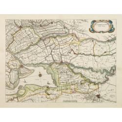
Zuydhollandia stricte sumta.
The count ship of Holland was subdivided into a number of bailiwicks. The most southerly bailiwick, bordering on Brabant was named Zuid-Holland. Many floods changed the a...
Date: Amsterdam, 1645
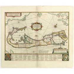
Mappa Aestivarum Insularum, alias Barmudas.
This magnificent map is based on the famous survey by John Norwood of the Bermuda Company in 1618. The map shows the division into the original Tribes and shows the vario...
- $2000 / ≈ €1731
Date: Amsterdam, 1645
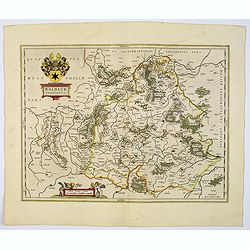
Juliacensis et Montensis Ducatus / De Hertoghdomen Gulick en Berghe.
Detailed map centered on Cologne. Embellished with scale cartouche with cherubs, a cartouche with a putti inside holding two coats of arms. Lower left corner, the title c...
- $150 / ≈ €130
Date: Amsterdam, 1645
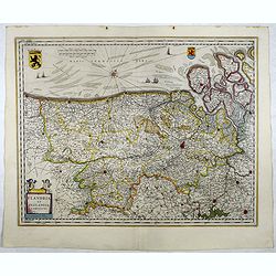
Flandria et Zeelandia Comitatus.
Includes Flanders and Zeeland. The map originally engraved in 1641 for Sanderus 'Flandria Illustrata', was used several times in Blaeu's atlases.More about maps by Willem...
- $250 / ≈ €216
Date: Amsterdam, 1645
Aethiopia inferior, vel exterior.
The standard map of South Africa throughout the 17th century. The lake out of which the 'Zambere' -the Zambesi- flows is probably based on reports of Lake Ngami, undiscov...
- $575 / ≈ €498
Date: Amsterdam, 1645
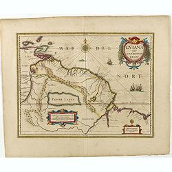
Guiana sive Amazonum Regio.
Copper engraving, hand colored in outline when published. A highly decorative map showing Guiana extending westwards to Trinidad and Margarita Island, dominated by a huge...
Date: Amsterdam, 1645
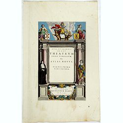
Title page from Theatrum Orbis Terrarum sive Atlas Novus Partis Prime Pars Altera.
Attractive title page of Blaeu's Theatrum Orbis Terrarum. The title is printed on a paste-on slip.Decorative and finely engraved architectural façade with figures. Some ...
- $400 / ≈ €346
Date: Amsterdam, 1645
Westphalia Ducatus.
Originally engraved for Jodocus Hondius II, at his death in August 1629, this map was, among 39 other copper plates, purchased by Willem Blaeu who deleted Hondius' name a...
Date: Amsterdam, 1645
Quarta pars Brabantiae cujus caput Sylvaducis.
The coat of arms of Brabant and 's-Hertogenbosch do appear on the map. But the municipal arms in the columns on right and left-hand side have not yet been filled in. The ...
Date: Amsterdam, 1645
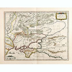
Taurica Chersonesus, Nostra aetate Prezecopsca, et Gazara dicitur.
Part of Russia with in the north Smolensk and including Moscow and in the south the Black Sea.More about Willem Blaeu. [+]Taurica, Tauric Chersonese, and Taurida were nam...
- $500 / ≈ €433
Date: Amsterdam, 1645
Wirtenberg Ducatus.
Map depicting the area south of Heidelberg, including Stuttgart, Ulm, etc.. and river Danube.A beautiful coat of arms and a splendid title cartouche decorated by three ch...
- $80 / ≈ €69
Date: Amsterdam, 1645
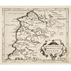
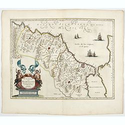
Marocchi Regnum.
From the Mercator/Hondius Atlas Minor. Early map of Morocco.
Date: Amsterdam, 1645
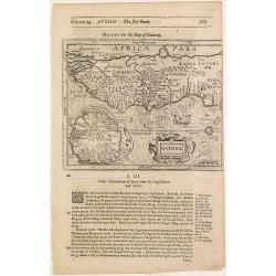
Guinea.
Samuel Purchas' edition of the Mercator/Hondius Atlas Minor . Map of Guinea published in his famous collection of voyages His Pilgrimes . With descriptive text in English...
Date: London, 1645
Novissima Russiae Tabula.
Detailed map of Russia including Scandinavia. Bottom left title cartouche and dedication. Prepared by Isaac Masso. Latin text on the verso.
Date: Amsterdam, 1645
Aethiopia inferior, vel exterior.
The standard map of South Africa throughout the 17th century. The lake out of which the 'Zambere' -the Zambesi- flows is probably based on reports of Lake Ngami, undiscov...
- $575 / ≈ €498
Date: Amsterdam, 1645
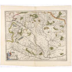
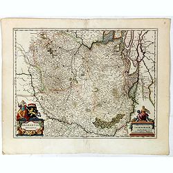
Hungaria Regnum.
Detailed map of Hungary centered on Budapest. Including the towns of Vienna, Zagreb as well.As Willem Blaeu died in 1638 most of his maps are actually published by his so...
Date: Amsterdam, 1645
Zuydhollandia stricte sumta.
The count ship of Holland was subdivided into a number of bailiwicks. The most southerly bailiwick, bordering on Brabant was named Zuid-Holland. Many floods changed the a...
- $350 / ≈ €303
Date: Amsterdam, 1645
Waldeck Comitatus.
Blaeu's attractive map of the region of Waldeck. Forests, hills and rivers all feature, along with towns villages and cities. Decorative title cartouche surmounted by coa...
- $100 / ≈ €87
Date: Amsterdam, 1645
Brabantia Ducatus.
A very decorative map by Willem Blaeu with west is at the top. On the lower left a magnificent cartouche with a sitting female figure carrying a globe and compasses and t...
Date: Amsterdam, 1645
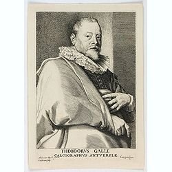
Theodorus Galle, Calcographus Anterpiæ.
Portrait of Theodorus Galle engraved by Lucas Vorsterman. Lucas Vorsterman was a Baroque engraver. He worked with the artists Peter Paul Rubens and Anthony van Dyck, as w...
Date: Antwerp, ca. 1645
Taurica Chersonesus, Nostra aetate Przecopsca, et Gazara dicitur.
Detailed map of the Ukraine, Russia with in the north Smolensk and Moscow and in the south the Black Sea. Shows ports, fortified cities and the mouths of the Danube. Mino...
- $750 / ≈ €649
Date: Amsterdam, 1645
Mappa Aestivarum Insularum, alias Barmudas. . .
It shows the island divided into tribes and lots, and below the map itself appear the coats of arms of Bermuda and England and the names of the first proprietors and the ...
Date: Amsterdam, 1645
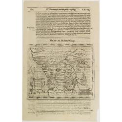
Congi regnu.
Samuel Purchas' edition of the Mercator/Hondius Atlas Minor . Early map of Congo published in his famous collection of voyages His Pilgrimes . With descriptive text in En...
Date: London, 1645