Browse Listings
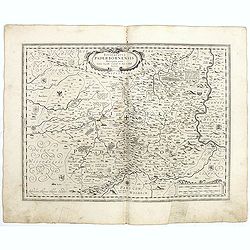
Episcopatus Paderbornensis
Detailed map centered on Paderborn. Prepared by Joannes Michael Gigas (1580-1650+), a doctor, mathematician and geographer who made also maps of Osnabrug, Westphalia, Mun...
Date: Amsterdam, 1629-1630
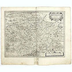
Westphalia Ducatus.
Elegantly engraved map of Westphalia including Hamm and Lippstadt. The mountainous topography is graphically depicted and several small coats of arms dot the map. Strapwo...
Date: Amsterdam, 1629-1630
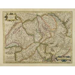
Helvetia cum finitimis regionibus confoederatis.
Detailed and finely engraved map of Switzerland.
- $350 / ≈ €303
Date: Amsterdam, 1630
Udrone Irlandiae in Catherlagh Baronia.
A detailed map of the Barony of Udrone (modern Idrone) in County Carlow, Ireland The title is surrounded by a strapwork design cartouche topped with calipers & a mile...
- $200 / ≈ €173
Date: Amsterdam, 1630
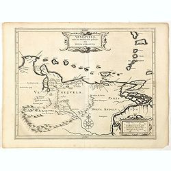
Venezuela, atque Occidentalis Pars Novæ Andalusiae.
Coastline of Venezuela with little interior development. Including Aruba, Bonaire, Curaçao, etc. Scarce map prepared by Hessel Gerritsz (1581-1632), former apprentice of...
- $600 / ≈ €519
Date: Leiden, Elzevier, 1630
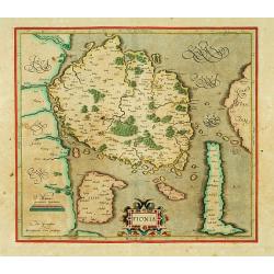
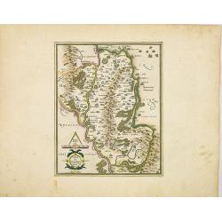
Fionia.
Early map, including Odense and the island Langeland .
- $200 / ≈ €173
Date: Amsterdam 1630
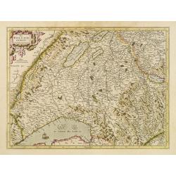
Das Wiflispurgergov.
In lower right Geneva and Lake Geneva with Lausanne. In center of map the cantons of Fribourg and Bern.
- $350 / ≈ €303
Date: Amsterdam 1630
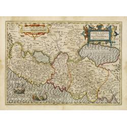
Terra Sancta que in Sacris Terra Promissionis ol: Palestina.
This map of Palestine extending from the Lebanon mountains to the Dead Sea is based on the large map by P.Laicksteen and Chr.'s-Grooten in the latter part of the sixteent...
Date: Amsterdam, 1630
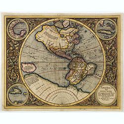
America sive India Nova.
This map was created by Michael Mercator, grandson of the great Gerard Mercator. It is the only map attributed to him. The map first appeared in 1595, one year after the ...
- $3000 / ≈ €2596
Date: Amsterdam, 1630
![[Title page] Thesauri Philo Polithi Tertia pars..](/uploads/cache/38445-250x250.jpg)
[Title page] Thesauri Philo Polithi Tertia pars..
Very skilfully engraved title page from a rare work printed by Eberhard Kieser: "Thesaurus Philo-Politicus. Das ist Politisches Schatzkästlein guter Herren und best...
- $80 / ≈ €69
Date: Frankfurt, 1630
![[Title page] Thesauri Philo-Politci Pars Sexta. . .](/uploads/cache/38446-250x250.jpg)
[Title page] Thesauri Philo-Politci Pars Sexta. . .
Very skilfully engraved title page from a rare work printed by Eberhard Kieser: Thesaurus Philo-Politicus. Das ist Politisches Schatzkästlein guter Herren und bestendige...
- $60 / ≈ €52
Date: Frankfurt, 1630
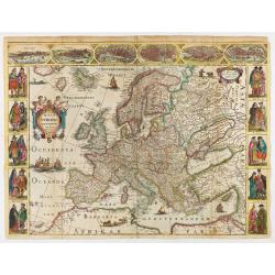
Nova Europae descriptio.
Rare early issue of the map of Europe with the lower border removed and without text on the reverse. Variant : The map has no longer the lower border, doesn't have text o...
Date: Amsterdam, after 1630
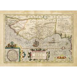
Guineae Nova Descriptio.
The map shows the West African coast from Senegal (the 'Rio Senega' is the Senegal River) to Cape Lopez on the Gulf of Guinea just below the equator. The island of St. Th...
- $450 / ≈ €389
Date: Amsterdam, 1630
Marca Brandeburgensis & Pomerania.
Centered on the towns of Brandenburg and Berlin. Based on the map by Elias Cameriarus (abt.1530-1581).RARE second state, with both the signatures of Gerard Mercator and H...
- $75 / ≈ €65
Date: Amsterdam, 1630
![[Titlepage] Germaniae tabule geographicae.](/uploads/cache/12197-250x250.jpg)
[Titlepage] Germaniae tabule geographicae.
Decorative title page to the volume of the "Atlas, Sive Cosmographicae Meditationes De Fabrica Mundi" devoted to maps of Germany. The design in a typical Manner...
- $280 / ≈ €242
Date: Amsterdam, 1630
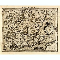
Warwicum Northampton, Huntingdon Cantabr etc.
Showing the south-eastern part of England. From his Atlas Minor. French text on verso.
- $100 / ≈ €87
Date: Amsterdam, c.1630
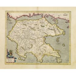
Morea olim Peloponnesus.
Gerard Mercator's map of the Greece's Peloponnesus peninsula called and labeled Morea. A few of the other smaller islands appear included the larger Cerigo (today's Cythe...
- $300 / ≈ €260
Date: Amsterdam, 1630
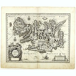
Tabula Islandiae. . .
With a very decorative cartouche, and a very fine imprint. No text on verso; included in the rare "Appendix" of 1630. VERY RARE. This handsome map of Iceland wa...
- $1200 / ≈ €1039
Date: Amsterdam, 1630
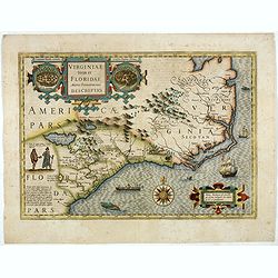
Virginiae item et Floridae. . .
Cummings describes it as one of the most beautifully executed maps ever made of the Southeast. In detail and in general conception it surpasses all earlier maps of the re...
- $2200 / ≈ €1904
Date: Amsterdam, 1630
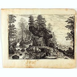
Blick auf eine Waldlandschaft mit reisenden Männern und einem Dorf in der Ferne.
Etching by Isaak Major and published by Jeremias Wolff depecting a view of a forest landscape with men traveling and a village in the distance. Large print edited by Jere...
- $200 / ≈ €173
Date: Augsburg, 1600-1630
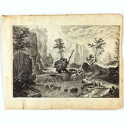
Landschaft mit Wasserfall und Schublade.
Etching by Isaak Major and published by Jeremias Wolff depecting a wide landscape with mountains ,rocks and a waterfall. Several people among withc a drawer at right. Lar...
- $150 / ≈ €130
Date: Augsburg, 1600-1630
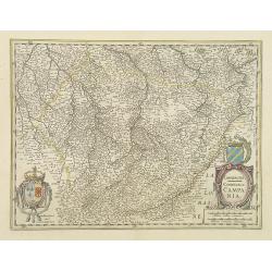
Champagne Comitatus Campania.
Map of French region of Champagne, including part of Lorraine. North to the east. The second state with the signature of J.Janssonius.
- $220 / ≈ €190
Date: Amsterdam, 1630
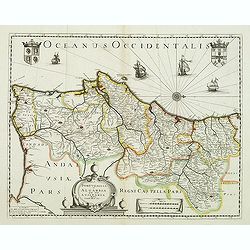
Portugallia et Algarbia quae olim Lusitania. . .
Rare map of Portugal with decorative title cartouche. Oriented to the west. Prepared by Fernando Alvares Seco.
Date: Paris, c.1630
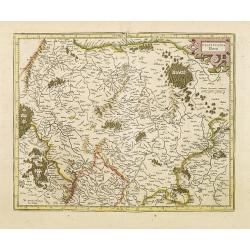
Palatinatus Rheni.
Map depicting part of Germany provinces.
Date: Amsterdam, 1630
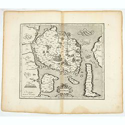
Fionia.
Early map, including Odense and the island Langeland .
- $200 / ≈ €173
Date: Amsterdam, 1630
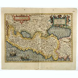
Terra Sancta que in Sacris Terra Promissionis ol: Palestina
This map of Palestine extending from the Lebanon mountains to the Dead Sea is based on the large map by P.Laicksteen and Chr.'s-Grooten in the latter part of the sixteent...
- $900 / ≈ €779
Date: Amsterdam, 1630
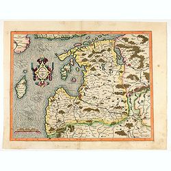
Livonia. 1627
Detailed map of the northern Baltic region. The map is centered on Riga and extends south to Memel, west to Poland and part of Russia and north to the Strait between Finl...
Date: Amsterdam, ca. 1630
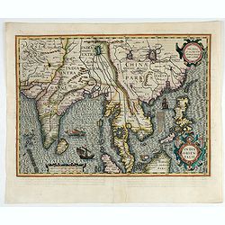
India Orientalis.
Published in Hondius' editions of the Mercator Atlas from 1606 onwards, showing the Indian subcontinent, the Malay Peninsula, Siam and Cambodia, China and the Philippines...
- $2000 / ≈ €1731
Date: Amsterdam, 1630
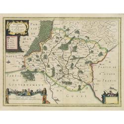
Description du Gouvernement de la CAPPELLE. Par P. Petit Bourbon.
RARE without text on verso. Decorative map of Cappellein the region of the Nord-Pas-de-Calais in France with three decorative cartouches.The map of Cappelle is by Pierre ...
- $150 / ≈ €130
Date: Amsterdam, 1631
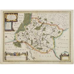
Description du Gouvernement de la CAPPELLE. Par P. Petit Bourbon.
Decorative map of Cappellein the region of the Nord-Pas-de-Calais in France with three decorative cartouches.The map of Cappelle is by Pierre Petit Bourbon (1598-1667), m...
- $100 / ≈ €87
Date: Amsterdam, 1631
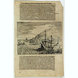
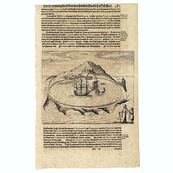
Cocos Insel Cocos Insula / Verräter Insel Insula proditorum.
Scarce print (148x204mm.) on a German text sheet showing the landing of Le Maire and Schouten at Cocos Island in May 1616 (today’s Tafahi in the Tonga Islands). Named b...
- $150 / ≈ €130
Date: Frankfurt, M.Merian, 1631
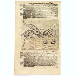
![[The attack by Schouten and his men on a waka.]](/uploads/cache/39754-250x250.jpg)
[The attack by Schouten and his men on a waka.]
Scarce print (145x210mm.) on a German text sheet showing the attack by Schouten and his men on a waka.The page is taken from a first edition of Johann Ludwig Gottfried's ...
- $150 / ≈ €130
Date: Frankfurt, M.Merian, 1631
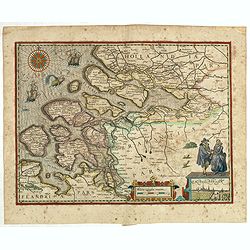
(Zeeland)
Rare map of Zeeland, first issued by Petrus Kaerius, than by Claes Jansz. Visscher. The copper plate was previously made by an anonymous engraver, and than came into the ...
- $1050 / ≈ €909
Date: Amsterdam, 1631
Vligen Insel.
Scarce print (168x200mm.) on a German text sheet showing the attack of mosquitos on Schouten's ship.The page is taken from a first edition of Johann Ludwig Gottfried's &q...
- $75 / ≈ €65
Date: Frankfurt, M. Merian, 1631
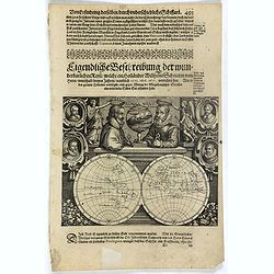
Description de nouveau pasage vers le zud.... together with an untitled map of Port Desire (today's Puerto Deseado, Argentina)
Rare double hemispherical world map showing the track round the world by Le Maire and Schouten in 1615-1617. Continents are marked in outline and no southern regions are ...
- $1500 / ≈ €1298
Date: Frankfurt, M.Merian, 1631
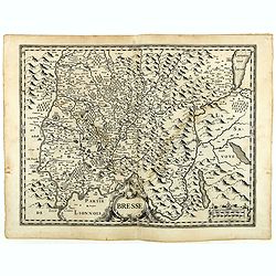
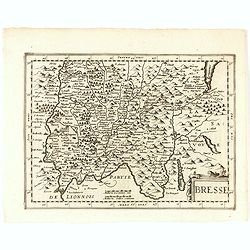
Bresse.
Early map of Eastern France with Lyon to the lower left corner and part of Switzerland. Geneva in upper right corner. Engraved by Hondius. From a French composite atlas.R...
- $150 / ≈ €130
Date: Amsterdam, 1631
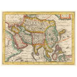
Asia.
Early map of Asia, including Korea as in peninsular.
Date: Amsterdam, 1632
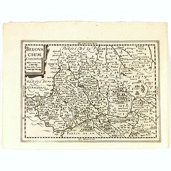
Belovacium comitatus.
Early map centered north of Paris. With Latin text on verso. Engraved by Petrus Kaerius. Shortly after the publication of big folio-atlases the need was apparently felt f...
- $75 / ≈ €65
Date: Amsterdam, 1632
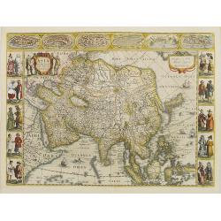
Asia recens summa cura delineata.
This is the rare early issue with decorative paneled borders. In upper border views and plans of Famagusta, Rhodos, Damascus, Jerusalem, Aden and Ormus. Originally engrav...
Date: Amsterdam, 1632
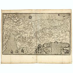
Pere Grinatie. De Reijse der Kinderen Israels so zij wt Egip . . .
Scarce separately engraved map of the Holy Land by Joannes van Doetecum Jr.In the lower right corner, inset with a title cartouche surrounded by Aaron, the encampment of ...
Date: Amsterdam, 1598, The Hague, 1632
Bresse.
Early map of Eastern France and part of Switzerland. Geneva in upper right corner. With Latin text on verso. Engraved by Petrus Kaerius. Shortly after the publication of ...
- $50 / ≈ €43
Date: Amsterdam, 1632
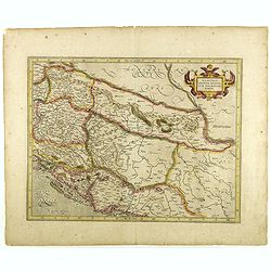
Sclavonia, Croatia, Bosnia cum Dalmatiae parte.
Nice map of the Eastern Balkans with the geographical & political divisions of Dalmatia, Croatia, Slavonia, Bosnia, Serbia, etc.Mercator was born in Rupelmonde in Fla...
- $250 / ≈ €216
Date: Amsterdam, 1632
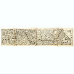
Totius Rheni, ab eius Capitibus ad Oceanu usque Germanicum in quem se Exonerat Novissima Descriptio.
The course of the Rhine river by Henricus Hondius. Originally engraved as two parts on one sheet. Here separated and joined to one large map. The map is showing the compl...
- $300 / ≈ €260
Date: Amsterdam, ca. 1632
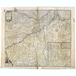
Ducatus Iuliacensis, Cliviensis, Montensis. et Comitatus Marciae et Rapens-Bergae finitimaeque eis Regiones de novo accurate in lucem editae. per Nicolaum I. Piscatorem. t'Amsterdam Gedruckt bij Claes Ianß. Visscher. Anno 1633.': .
Claes Visscher map of the German Duchies Jülich, Cleves, Berg with the County of Mark. - Bottom right is an inset map the country around Ravensberg. Top left is a pretty...
- $250 / ≈ €216
Date: Amsterdam, 1632
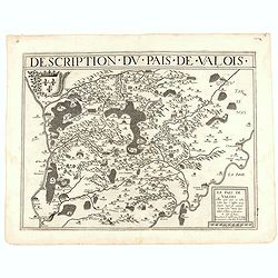
Description du pais de Valois.
Rare map published by Jean Le Clerc (1560-1621) and prepared by Damien de Templeux map of the region to the northeast of Paris, between the Oise River in the west and the...
- $300 / ≈ €260
Date: Paris, 1632
![[Indians attacked near Cartagena.]](/uploads/cache/40076-250x250.jpg)
[Indians attacked near Cartagena.]
When the governor of Cartagena, Alonso de Ojeda, led a party of Spanish soldiers into the interior to search for gold, they were attacked by Indians with such ferocity th...
Date: Frankfurt, M.Merian, 1633
![Les Petit Voyages [Solor].](/uploads/cache/37958-250x250.jpg)
Les Petit Voyages [Solor].
This work by de Bry comprises probably the greatest single collection of material on early voyages to the East Indies, and are unique in their extraordinary wealth of car...
- $100 / ≈ €87
Date: Frankfurt, 1601 - 1633
![[How the women tease their captives.]](/uploads/cache/40478-250x250.jpg)
[How the women tease their captives.]
The Indian women led their captive, Staden, into the middle of the hamlet. Then they decorated his head with feathers and his legs with rattles. After forming a circle ro...
Date: Frankfurt, M.Merian, 1633
Solor.
Scarce print on German text sheet showing the Island of Solor. From "Petits Voyages". The island Solar, to the north of Timor, has a high mountain and has a ver...
- $100 / ≈ €87
Date: Frankfurt, M.Merian, 1633
![[Columbus lands on the Island of San Salvador.]](/uploads/cache/40479-250x250.jpg)
[Columbus lands on the Island of San Salvador.]
On 12th October 1492, after 33 days at sea, Columbus sighted land. His three ships made their way round the south-west point of an island Columbus named San Salvador - be...
- $100 / ≈ €87
Date: Frankfurt, M.Merian, 1633
![[Collective suicide under Spanish rule.]](/uploads/cache/40480-250x250.jpg)
[Collective suicide under Spanish rule.]
The natives of Hispaniola, who saw no end to the fearful oppression of Spanish rule, preferred death. So many, devoid of all hope, went into the woods to kill their child...
- $80 / ≈ €69
Date: Frankfurt, M.Merian, 1633
![[Another Dutch fleet reaches Lima].](/uploads/cache/41117-250x250.jpg)
[Another Dutch fleet reaches Lima].
In 1624 a heavily armed Dutch fleet sailed from the Juan Fernandez Islands to Lima. The leader of the fleet, Jacob l’Hermite, was in such poor health that he had to han...
Date: Frankfurt, M.Merian, 1633
![[John Smith caught by the French].](/uploads/cache/41114-250x250.jpg)
[John Smith caught by the French].
In 1615, during one of John Smith’s voyages across the Atlantic, he was caught by some French pirates. While at sea in captivity he was forced to suffer great hardships...
Date: Frankfurt, M.Merian, 1633
![[The adventures of the Dutch at 'Bottomless' island in Samoa].](/uploads/cache/41106-250x250.jpg)
[The adventures of the Dutch at 'Bottomless' island in Samoa].
The Dutch arrived at an island [in Samoa] fringed with wild vines on which there were native men with long hair and native women with short hair. Because the water surrou...
Date: Frankfurt, M.Merian, 1633
![[English attack Praia.]](/uploads/cache/39900-250x250.jpg)
[English attack Praia.]
Scarce print with German text sheet showing the English attack on Praia. On 16 November, 1585, during Francis Drake’s round-the-world voyage, his fleet anchored off San...
- $150 / ≈ €130
Date: Frankfurt, M.Merian, 1633
![[Dutch attack the fortress of Praia.]](/uploads/cache/39901-250x250.jpg)
[Dutch attack the fortress of Praia.]
Scarce print with German text sheet showing the Dutch attack on Praia.On 27th June 1589, Simon de Cordes left Holland with five ships, bound for the Magellan Straits. On ...
- $80 / ≈ €69
Date: Frankfurt, M.Merian, 1633
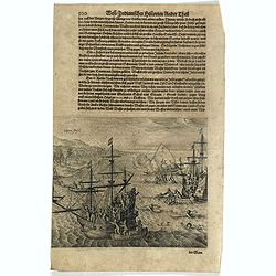
S. Jago.
Scarce print with German text sheet showing the Dutch at Santiago. The Dutch were invited to visit the harbour, about two miles along the coast. On arrival, they found it...
- $100 / ≈ €87
Date: Frankfurt, M.Merian, 1633
![[The Dutch are received at another island in Samoa].](/uploads/cache/41105-250x250.jpg)
[The Dutch are received at another island in Samoa].
On visiting another island [in Samoa] the Dutch were made heartily welcome by the king and all the inhabitants. A king of another neighbouring island also called to meet ...
Date: Frankfurt, M.Merian, 1633
![[Atahualpa captured by Spanish.]](/uploads/cache/40352-250x250.jpg)
[Atahualpa captured by Spanish.]
Accompanying Pizarro was a monk called Valverde, who confronted Atahualpa with a crucifix and breviary. The interpreter said the Spanish had been sent by their emperor to...
- $80 / ≈ €69
Date: Frankfurt, M.Merian, 1633
![[The natives eat, drink and dance for their king].](/uploads/cache/41104-250x250.jpg)
[The natives eat, drink and dance for their king].
Food was carried on the natives’ heads as they humbly crept forward on their knees to greet the Dutch. The drink, called cava, was made from a certain plant, which they...
Date: Frankfurt, M.Merian, 1633
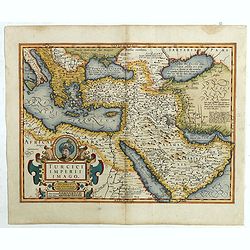
Turcici Imperii Imago.
A very decorative map. On top of title cartouche the portrait of Sultan Mahumet Turcorum Imperat .More about Mapping of Arabia [+]
- $1000 / ≈ €865
Date: Amsterdam, 1633
![[Isle la Moche].](/uploads/cache/39909-250x250.jpg)
[Isle la Moche].
Scarce print with a German text sheet showing the Dutch fleet anchored off the Island of Mocha, near Concepción in Chile. The islanders sat on wooden stumps and watched ...
- $100 / ≈ €87
Date: Frankfurt, M.Merian, 1633
![[Cavendish reaches Morro Moreno.]](/uploads/cache/39910-250x250.jpg)
[Cavendish reaches Morro Moreno.]
Scarce print with a German text sheet showing Cavendish’s fleet anchor at a place called Morro Moreno, on the coast of Chile. The Indians came down from the high cliffs...
- $80 / ≈ €69
Date: Frankfurt, M.Merian, 1633
![[French seizure of Chiorera.]](/uploads/cache/39911-250x250.jpg)
[French seizure of Chiorera.]
Scarce print with a German text sheet showing the French torching and looting Chiorera. From de Bry's "Great American Voyages". Johann Theodor de Bry (1561-1623...
- $80 / ≈ €69
Date: Frankfurt, M.Merian, 1633
![[Sir Walter Ralegh meets the King of Arromaia].](/uploads/cache/39916-250x250.jpg)
[Sir Walter Ralegh meets the King of Arromaia].
Scarce print with a German text sheet. During Ralegh’s voyage up the Orinoco in search of El Dorado, he met an old man who said he was the king of Arromaia. He claimed ...
- $125 / ≈ €108
Date: Frankfurt, M.Merian, 1633
![[Black slaves escape punishment].](/uploads/cache/39920-250x250.jpg)
[Black slaves escape punishment].
Scarce print with a German text sheet. Many Black slaves, weary of ill treatment, managed to escape Spanish captivity and freely wandered the island, breaking into prison...
- $80 / ≈ €69
Date: Frankfurt, M.Merian, 1633
![[Diego de Almagro is killed.]](/uploads/cache/40354-250x250.jpg)
[Diego de Almagro is killed.]
Almagro returned to Cuzco, disillusioned and embittered from his long and fruitless journey south into Chile, where he had been searching for further wealth. This led to ...
- $80 / ≈ €69
Date: Frankfurt, M.Merian, 1633
![[Religious ritual on Hispaniola].](/uploads/cache/39921-250x250.jpg)
[Religious ritual on Hispaniola].
Scarce print with a German text sheet.On certain feast-days the Indian cacique, while beating a drum, led a procession of his people to the worship of their idol, which w...
- $80 / ≈ €69
Date: Frankfurt, M.Merian, 1633
![[Montezuma's dream as told by a labourer, predicts calamties to come.]](/uploads/cache/40371-250x250.jpg)
[Montezuma's dream as told by a labourer, predicts calamties to come.]
An apocalyptic scene of Montzuma's dream .In 1631 Johann Ludwig Gottfried, inherited the Theodor De Bry’s publishing firm, among the illustrated accounts of the expedit...
- $100 / ≈ €87
Date: Frankfurt, M.Merian, 1633
![[The ritual of the killing.]](/uploads/cache/40081-250x250.jpg)
[The ritual of the killing.]
On the day of the killing, the rope is untied from the prisoner’s neck, then put round his body and pulled tightly from both ends. A fire burns in front of the prisoner...
Date: Frankfurt, M.Merian, 1633
![[Revenge for Juan de Ayola's death.]](/uploads/cache/40083-250x250.jpg)
[Revenge for Juan de Ayola's death.]
During Ayolas’s travels in Paraguay, he founded the fort at La Candelaria, near Corumba but later, while returning to Asunción, he and his entire party were killed by ...
Date: Frankfurt, M.Merian, 1633
![[Vespucci lands on the Island of Itius.]](/uploads/cache/40486-250x250.jpg)
[Vespucci lands on the Island of Itius.]
According to the esteemed historian, Las Casas,‘Itius cannot be other than the islands we reach coming from Spain, named Guadeloupe and Dominica.When Vespucci and his S...
Date: Frankfurt, M.Merian, 1633
![De Sota meets the Inca king near Cajamarca.]](/uploads/cache/40485-250x250.jpg)
De Sota meets the Inca king near Cajamarca.]
When the Spanish arrived in Cajamarca, they found only a few inhabitants. The Inca army was camped in the surrounding hills and the residence of the Inca king, Atahualpa,...
Date: Frankfurt, M.Merian, 1633

Composite atlas of the Low Countries.
A unique, made-to-order atlas comprising 18 double-page engraved maps by or after Hessel Gerritsz, Theodoor Galle, Jacob van Deventer, Gerard Mercator, Peter Verbiest, Je...
Date: [Antwerp, c. 1633
![Praelium Divrnum. [Spanish fleet defeated by the Dutch] / Nocturnum Praelium [Dutch and Spanish at sea off Lima].](/uploads/cache/41087-250x250.jpg)
Praelium Divrnum. [Spanish fleet defeated by the Dutch] / Nocturnum Praelium [Dutch and Spanish at sea off Lima].
Two engravings. [498] On the evening of 17th July, 1615, Spilbergen’s Dutch fleet encountered, off the coast of Peru near Lima, the powerful fleet of the Spanish, under...
Date: Frankfurt, M.Merian, 1633
![[The bloody battle at Chupas] / [Francesco Pizzaro is killed].](/uploads/cache/41093-250x250.jpg)
[The bloody battle at Chupas] / [Francesco Pizzaro is killed].
Two engravings. [492] Even before Pizarro’s death, a new royal governor, Vaca de Castro, was on his way to settle the turmoil in Peru. He refused to accept Almagro the ...
Date: Frankfurt, M.Merian, 1633
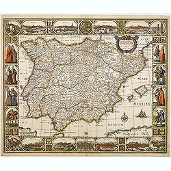
Nova et accurata Tabula Hispaniae. . .
Second state. This "carte à figures"- map of Spain and Portugal shows the geographical image introduced by Hessel Gerritsz's 1612 wall map of Spain. The map is...
Date: Amsterdam, 1633
![[Natives of America offering Vaso Balbao gold.]](/uploads/cache/40362-250x250.jpg)
[Natives of America offering Vaso Balbao gold.]
This early engraving shows natives of America offering Vaso Balbao gold. In 1511, Nuñez de Balboa formed a colony on the banks of the Atrato, in the Gulf of Uraba. Two y...
- $100 / ≈ €87
Date: Frankfurt, M.Merian, 1633
![[How the Inca nobility are buried] / [Bridge of Huaynacapaco]](/uploads/cache/41094-250x250.jpg)
[How the Inca nobility are buried] / [Bridge of Huaynacapaco]
Two engravings. [470] The funeral of an Inca king was a ceremony of great splendor. After digging a large pit, the Indians would decorate the corpse with gold and silver ...
Date: Frankfurt, M.Merian, 1633
![[How Incas wrought their gold.]](/uploads/cache/40080-250x250.jpg)
[How Incas wrought their gold.]
The goldsmiths of Huayna-Capac were master craftsmen who wrought gold into magnificent artefacts with the simplest of tools. They used clay furnaces, heated by coals and ...
Date: Frankfurt, M.Merian, 1633