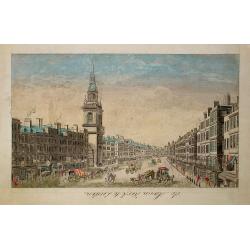
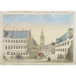
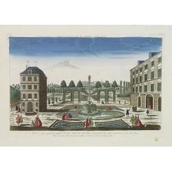
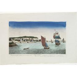
Browse Listings in Europe
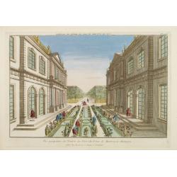
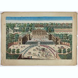
Vue perspective de l'Entrée du Parc du Prince de Manheim en Allemagne.
Perspective view of the Royal Park in Manheim by Basset, a well-known publisher of optical prints, established in rue St.Jacques in Paris. With brief key list.In the eigh...
- $200 / ≈ €175
Date: Paris, 1760

15e. Vüe d'Optique Representant Le Profil du Palais de Petersbourg.
So-called optical print illustrating a perspective view of the portico of a Palace in Saint Petersburg. Published by Daumont, a well-known publisher of optical prints, es...
- $250 / ≈ €218
Date: Paris, 1760
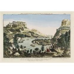
Vue perspective de la Ville et Forteresse Electorale de Koningstein, et de la Montagne de Lilienstein avec ses environs du côté du Couchant, dépendant des Etats de Saxe, appartenant à Sa Majesté le Roy de Pologne.
1760 BASSET - Perspective view of Königstein fortress, situated near Dresden in Saxony
Date: Paris, 1760

Vüe de Morestburg en Saxe, l'une des Maisons de Chasse du Roy de Pologne. (Castle Moritzburg)
So-called optical print illustrating a perspective view of the Castle Moritzburg, a Baroque Germanic castle in the small town of Moritzburg in the German state of Saxony....
- $250 / ≈ €218
Date: Paris, 1760

A view of BILNITZ in Saxony one of the palaces of the King of Poland. / Vüe de Bilnitz, en Saxe, un des Palais du Roi de Pologne.
So-called optical print illustrating a perspective view of Pillnitz Castle, a restored Baroque castle at the eastern end of the city of Dresden. The castle was once the s...
- $300 / ≈ €262
Date: Paris, 1760

Vuë Perspective de l'interieur du superbe Palais du Prince Eugene.
So-called optical print illustrating a perspective view of Prince Eugene of Savoy's palace. After a design of Kleiner.In the eighteenth and nineteenth centuries, there we...
- $195 / ≈ €170
Date: Paris, 1760
Vue de la Fontaine des Eaux chaudes et de la place d'Aix la Chapelle.
So-called optical print illustrating a perspective view of Aachen, in Nordrhein Westphalia, and namely the Elisa Fountain which contains two fountains with thermal water....
- $250 / ≈ €218
Date: Paris, 1760
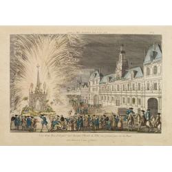
Vue d'un Feu d'Artifice tiré devant l'Hotel de Ville en réjouissance de la Paix.
Optical view, illustrating a fireworks display in front of the Paris city hall.In the eighteenth and nineteenth centuries there were many popular speciality establishment...
Date: Paris 1760
De Maria kerk te Leiden.
In the eighteenth and nineteenth centuries, there were many popular speciality establishments in Paris, Augsburg and London that produced optical viewing devices and spec...
- $200 / ≈ €175
Date: Paris, 1760
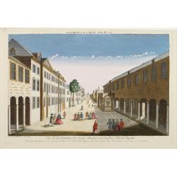
Vue d'Ausbourg prise de la Cathedrale regardant vers la Porte de la Sainte Vierge.
Charming view of the Cathedral (Dom St. Maria) in Augsburg. In top of the print the title, in mirror image, in manuscript. Published by André Basset, the younger engrave...
- $100 / ≈ €87
Date: Paris, ca 1760
Vue et perspective d'un Jardin du Roy d'Angleterre aux environs de Londres.
So-called optical print of one of the King's Royal Gardens in the London vicinities.Published by the brothers Chéreau, active in Paris at rue St. Jacques au dessus de la...
- $150 / ≈ €131
Date: Paris, 1760
Prospectus Purfleet ad Tamesim in Comitatu Essex Representant le Purfleet sur la Tamise dans le Comté d'Essex. 21e VUE d'Optique.
A so-called optical print of the vessel Purfleet navigating on the River Thames in Essex, England. Published by the brothers Chéreau, active in Paris at rue St. Jacques...
- $300 / ≈ €262
Date: Paris, 1760

Vue de la Partie Sud Est du Château de Windsor avec la Famille Royale sur la Terrasse. Et vue du Palais de la Reine.
A so-called optical print view of the Royal family at the terrace of the South East wing of Windsor Castle as well as the Queen's Palace. Published by the brothers Chére...
- $200 / ≈ €175
Date: Paris, 1760
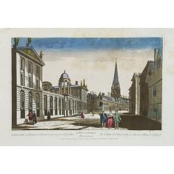
Universatis ae Reginae Collegiorum prospectus Oxfordiae Représentant le College de l'Université, et celui de la Reine a Oxford. 63 Vue d'optique.
A so-called optical print of Queens College on High Street in Oxford. As most optical prints, due to the fact that they are used to be looked at in a mirror, the subject ...
- $275 / ≈ €240
Date: Paris, 1760
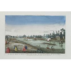
Vue d'une des Maison de Plaisance et d'une partie du Parc du Comte de Burlington du Coté de la Tamise.
A so-called optical print of Burlington County and the River Thames. Published by the brothers Chéreau, active in Paris at rue St. Jacques au dessus de la Fontaine St. S...
- $225 / ≈ €197
Date: Paris, 1760
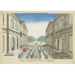
Entree du parc du Prince à Manheim.
Perspective view of the Royal Park in Manheim by Basset, a well-known publisher of optical prints, established in rue St.Jacques in Paris. With a brief key list.In the ei...
- $75 / ≈ €66
Date: Paris, 1760
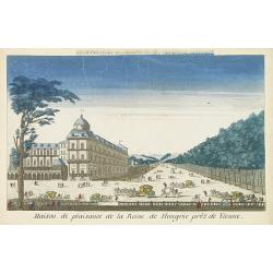
Maison de plaisance de la reine de Hongrie pres de Vienne.
Perspective view of the castle of the queen of Hungary near Vienna. Basset was a well-known publisher of optical prints, established in rue St.Jacques in Paris. With brie...
Date: Paris, 1760
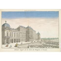
Palais royal de la reine de Hongrie à Vienne.
Perspective view of the royal palace of the queen of Hungry, in Vienna, a well-known publisher of optical prints, established in rue St.Jacques in Paris. With brief key l...
Date: Paris, 1760
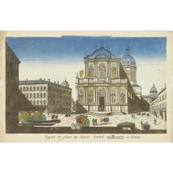
Eglise et place de Saint Andre dellavalle à Rome.
Perspective view of the church and place Sant'Andrea della Valle church in Rome. Sant'Andrea della Valle later became a model for the construction of other churches like ...
Date: Paris, 1760
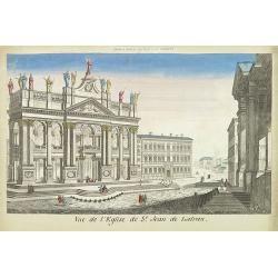
Vue de l'eglise de St Jean de Latran.
So-called optical print of the church Saint Jean de Latran, by Basset a well-known publisher of optical prints, established in rue St.Jacques in Paris. With brief key lis...
- $150 / ≈ €131
Date: Paris, 1760

Maison de plaisance près de Parme.
So-called optical print of a country house near Parma, by the well-known publisher of optical prints, Basset, established in rue St.Jacques in Paris.In the eighteenth and...
- $150 / ≈ €131
Date: Paris, 1760

Vue d'un château d'Archangel.
So-called optical print of a street and house in Arkhangelsk, by the well-known publisher of optical prints, Basset, established in rue St.Jacques in Paris. In the eighte...
- $300 / ≈ €262
Date: Paris, 1760

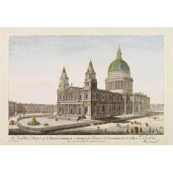
5e Vue d'Optique Representant La Vue interieure de la Cathedralle de St. Paul de Londres.
So-called optical print illustrating a perspective view of the interior of the Saint Paul cathedral in London. Engraved by la Marcade.In the eighteenth and nineteenth cen...
Date: Paris, 1760
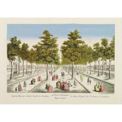
40e Vue d'Optique Representant Le Parc Royal de St. James a Londres.
So-called optical print illustrating a perspective view of Saint James Park, in London.In the eighteenth and nineteenth centuries there were many popular speciality estab...
- $250 / ≈ €218
Date: Paris, 1760
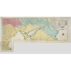
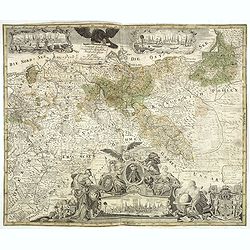
![Partie septentrionale du cercle de Haute Saxe [...] Brandebourg.](/uploads/cache/64110-250x250.jpg)
Partie septentrionale du cercle de Haute Saxe [...] Brandebourg.
Finely and crisply engraved map of north eastern part of Germany, including part of Poland. With inset map of Brandenburg. Map by Giles Didier Robert De Vaugondy with era...
- $150 / ≈ €131
Date: Paris, c. 1760
The North West Prospect of S. Pauls Cathedral in London.
Uncommon optical print illustrating a view of St. Paul's Cathedral in London.In the eighteenth and nineteenth centuries there were many popular speciality establishments ...
- $275 / ≈ €240
Date: Paris, 1760
![Partie septentrionale du cercle de Haute Saxe [...] Brandebourg.](/uploads/cache/33211-250x250.jpg)
Partie septentrionale du cercle de Haute Saxe [...] Brandebourg.
Finely and crisply engraved map of north eastern part of Germany, including part of Poland. With inset map of Brandenburg. Map by Giles Didier Robert De Vaugondy with era...
Date: Paris, c. 1760
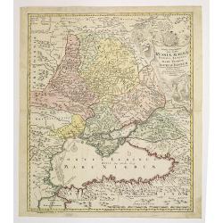
Carte géographique représentant le théâtre de la guerre entre les Russes, les Turcs et les Polonois confédérés. . .
Interesting and rare map showing the area of the Russo-Turkish Wars. To the right a large title cartouche and extensive text describing the different stages and the Wars ...
- $1500 / ≈ €1310
Date: Augsburg, 1760
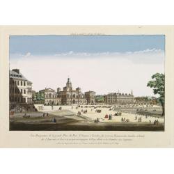
Vüe Perspective de la grande Place du Parc St. Jacques à Londres, du nouveau Batiment des Gardes a Cheval, de l'Amirauté..
So-called optical print illustrating a cortege of subjects accompanying the king to the House of Lords along the Horse guards Road in St. James's Park, in London.The Old ...
- $200 / ≈ €175
Date: Paris, 1760

Prospect des grossen Arno Platzes in Florenz.
Rare so-called optical print illustrating a Street scene in Florence with the Palazzo Vecchio (town hall) and its Duomo (cathedral) in the background. Engraved by Balth F...
- $250 / ≈ €218
Date: Augsburg, 1760
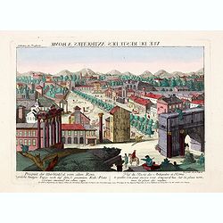
Prospect der Überbleibssel von altem Rome. - Vue du Reste des Antiquites a Rome.
A rare so-called optical print illustrates Roman Forum, ancient Rome's showpiece center, a grandiose district of marble-clad temples, proud basilicas and vibrant public s...
- $250 / ≈ €218
Date: Augsburg, 1760
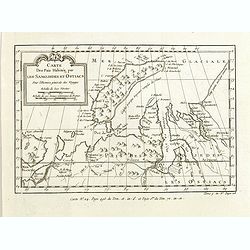
Carte des Païs habités par les Samojedes et Ostiacs, pour l'histoire générale des voyages.
Map shows Nova Zembla and the area of northern Russia that was inhabited by the Samoyeds and Ostiacs.Prepared by Jacques Nicolas Bellin after Dutch sources and included i...
- $75 / ≈ €66
Date: Paris, 1760
Vue et Perspective de la Trinité a Vienne.
Decorative perspective view of a square in Vienna centered on the column, which represents the Trinity. Published by Jacques François Chereau [1742 -1794], who was activ...
- $200 / ≈ €175
Date: Paris, 1760
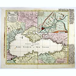
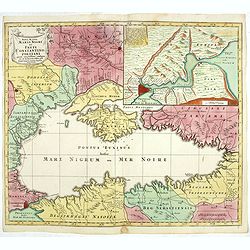
Nova Mappa Maris Nigris et Freti Constantinopolitani...
Map of the Black Sea with the Crimea and adjacent countries, inset map of the Bosporus with Constantinople at upper right.T.C. Lotter married M. Seutter's daughter in 174...
- $600 / ≈ €524
Date: Augsburg, ca. 1760
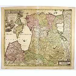
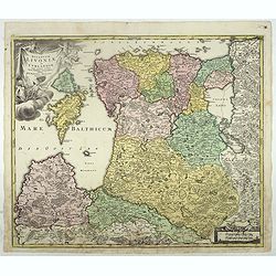
Dvcatvvm Livoniae et Cvrlandiae cum vicinis insulis nova exhibitio geographica.
A very attractive of Livonia, Estonia, Curlandia and the Baltic coast, which also includes the Gulf of Livonia or Riga.
- $500 / ≈ €437
Date: Nuremberg, 1760
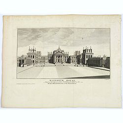
Blenheim House.
An attractive view of the front of Blenheim House (now Palace) home to the present 12th Duke and Duchess of Marlborough. The house was begun in 1705, built by Sir John Va...
- $50 / ≈ €44
Date: London, ca. 1760
Dvcatvvm Livoniae et Cvrlandiae cum vicinis insulis nova exhibitio geographica.
A very attractive of Livonia, Estonia, Curlandia and the Baltic coast, which also includes the Gulf of Livonia or Riga.
- $450 / ≈ €393
Date: Nuremberg, 1760
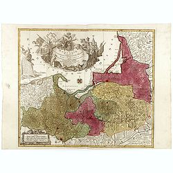
Borussiae Regnum compectens Circulos Sambiensem, Natangiensem, et Hockerlandiae Nee non Borussia Polonica, exhibens Palatinatus Culmiensem. . .
Decorative map covering northern Poland with Prussia, Pomerania, Hockerlandia, Warmiaermelandia, Natanglensis, Galindia, Nandrovia, Sclavonia, and the Baltic Sea. Include...
- $400 / ≈ €349
Date: Augsburg, ca. 1760
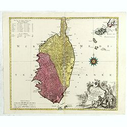
L'isle de Corse avec les différents districts, appartenante à la République de gênes . . .
Map published during the uprising of the Corsican people against the Republic of Genoa. It is decorated with a wind rose compass and a beautiful title cartouche decorated...
Date: Augsburg, 1760
Generale Carte der gesamten Koniglichen Preussischen Lander. . .
Beautiful and rare two sheet map of Prussia. The title cartouche is hold by a crowned eagle. In lower part a large baroque cartouche with allegorical figures and a portra...
- $1200 / ≈ €1048
Date: Berlin, 1760
Nova Mappa Maris Nigri et Freti Constantino Politani. . .
Decorative and uncommon map the Black Sea region. In upper left hand corner an inset map (200 x 280mm) of the Bosporus including Istanbul. Title engraved onto a drape-sty...
- $450 / ≈ €393
Date: Augsburg, ca. 1760
Les Suisses leurs sujets et leurs alliez. . .
Un uncommon map of Switzerland by Nolin.
- $250 / ≈ €218
Date: Paris, ca. 1760
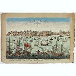
Lisbone Ville Capitale du Royaume de Portugal…
A very RARE panoramic view of the city of Lisbon, including a numbered legend in the lower part : 1-28.The plate, at the joint address of Esnault et Rapilly and Daumont,...
Date: Paris, c. 1760
Veuë et Pers-pective de l'Entrée du Château de Marly en général.
A rare panoramic view of the Château de Marly (Marly-le-Roi) by Aveline. The plate, at the joint address of Esnault et Rapilly and Daumont, is numbered in upper right co...
- $250 / ≈ €218
Date: Paris, c. 1760

Nieuwe Paskaart van het Westerlykste Gedeelte van HET KANAAL strekkende aan de ENGELSCHE KUST van Poortland tot de Sorlinges. . .
Nieuwe Paskaart van het Westerlykste Gedeelte van HET KANAAL strekkende aan de ENGELSCHE KUST van Poortland tot de Sorlinges en aan de Fransche kust van het Eylandt Guern...
- $900 / ≈ €786
Date: Amsterdam, 1760

Vue perspective de la Galerie Royale de Copenhague conduisant au Jardin.
So-called optical print illustrating a perspective view of the Royal Portico in Copenhagen.Mondhare was a well-known publisher of optical prints, established in Paris. In...
Date: Paris 1761

Vue de la superbe Gallerie de Petersbourg en Russie.
So-called optical print illustrates a perspective view of the interior of a palace in Saint Petersburg.Mondhare was a well-known publisher of optical prints, established ...
- $200 / ≈ €175
Date: Paris, 1761
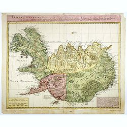
Insulae Islandiae delineatio : prout haec Solenni mensurandi negotio sub Auspiciis Potensissimi Regis Daniae facto . . .
Detailed and important map of Iceland, prepared by Th. H. Knoff and O. Ranzow and published by the Homann Heirs. The map is more scientific than many previous similar ver...
- $850 / ≈ €743
Date: Nuremberg, 1761
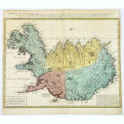
Insula Islandiae delineatio. . .
A nice large map of Iceland published by Homann Heirs. The country is divided up into four differently colored regions, lettered title to top of map, boxed mileage scales...
- $900 / ≈ €786
Date: Nuremberg, 1761
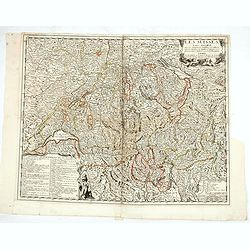
Le Comté de Tirol, les Evèchés de Trente et de Brixen..
Detailed map of Austria showing territories of Tyrol, Bavaria, Brixen. Engraved by Cordier.
Date: Paris, 1761
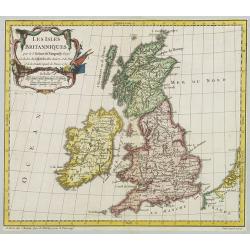
Les Isles Britanniques..
A first state (of 2) dated 1762. Fine map of the British Isles, engraved by E.Dussy. Fine title cartouche upper left engraved by Arrivet. From his Nouvel Atlas Portatif .
Date: Paris, 1762
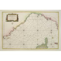
Carte Hydrographique De La Baye De Cadix. . .
Beautiful chart of the Bay of Cadiz, from Rota to Cadiz, with dramatic coastal topography, soundings, anchorages, forts, loxodromic lines, compass rose and large decorati...
Date: Paris, 1762
![[Mer Baltique]](/uploads/cache/37796-250x250.jpg)
[Mer Baltique]
Detailed map of Northern part of Poland with Danzig, from his "Atlas moderne ou collection de cartes...".map N° 15.
- $300 / ≈ €262
Date: Paris, 1762
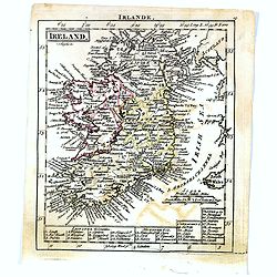
Ireland.
Uncommon miniature map of Ireland, engraved by J. Bayly for "A New General and Universal Atlas Containing Forty five Maps by Andrew Dury".This miniature atlas p...
- $50 / ≈ €44
Date: London, 1761-1763
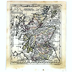
A map of Scotland.
Uncommon miniature map of Scotland, engraved by Thomas Kitching for "A New General and Universal Atlas Containing Forty five Maps by Andrew Dury".This miniature...
- $50 / ≈ €44
Date: London, 1761-1763
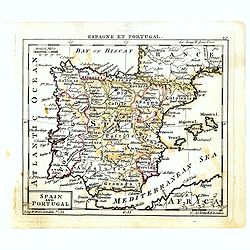
Spain and Portugal.
Uncommon miniature map of Spain and Portugal, engraved by Thomas Kitching for "A New General and Universal Atlas Containing Forty five Maps by Andrew Dury".This...
- $60 / ≈ €52
Date: London, 1761-1763
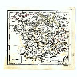
France.
Uncommon miniature map of France, engraved by J.Spilbury for "A New General and Universal Atlas Containing Forty five Maps by Andrew Dury".This miniature atlas ...
- $50 / ≈ €44
Date: London, 1761-1763
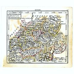
Switzerland divided into Cantonments.
Uncommon miniature map of Switzerland, engraved by Thomas Kitching for "A New General and Universal Atlas Containing Forty five Maps by Andrew Dury".This miniat...
- $30 / ≈ €26
Date: London, 1761-1763
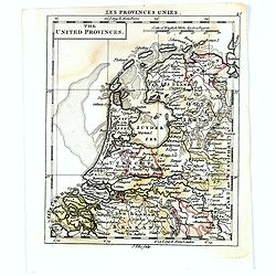
The United Provincies.
Uncommon miniature map of The Netherlands, engraved by J.Ellis for "A New General and Universal Atlas Containing Forty five Maps by Andrew Dury".This miniature ...
- $50 / ≈ €44
Date: London, 1761-1763
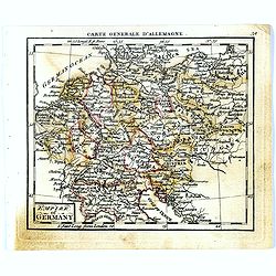
Empire of Germany.
Uncommon miniature map of Germany, Poland, the Low Countries and Eastern Europe, engraved by Thomas Kitching for "A New General and Universal Atlas Containing Forty ...
- $40 / ≈ €35
Date: London, 1761-1763
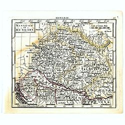
Kingdom of Hungary.
Uncommon miniature map of Hungary, engraved by Thomas Kitching for "A New General and Universal Atlas Containing Forty five Maps by Andrew Dury".This miniature ...
- $75 / ≈ €66
Date: London, 1761-1763
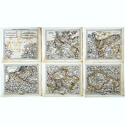
The Empire of Germany.
Uncommon miniature map in six sheets of the Empire of Germany, engraved by Thomas Kitching for "A New General and Universal Atlas Containing Forty five Maps by Andre...
- $75 / ≈ €66
Date: London, 1761-1763
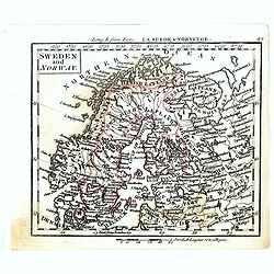
Sweden and Norway.
Uncommon miniature map of Sweden and Norway, engraved by Thomas Kitching for "A New General and Universal Atlas Containing Forty five Maps by Andrew Dury".This ...
- $75 / ≈ €66
Date: London, 1761-1763
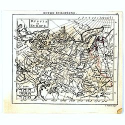
Russia in Europe.
Uncommon miniature map of Russia, engraved by Thomas Kitching for "A New General and Universal Atlas Containing Forty five Maps by Andrew Dury".This miniature a...
- $75 / ≈ €66
Date: London, 1761-1763
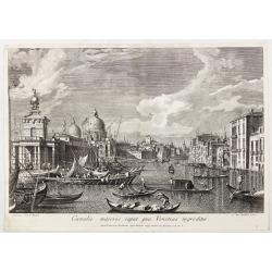
Canalis majoris caput qua Venetias ingreditur.
Canalis majoris caput qua Venetias ingreditur". A view of the Grand Canal with Santa Maria della Salute to the left after Canaletto.From the series "Prospectum ...
Date: Venice, c. 1763
![[56] I.Scio.](/uploads/cache/12828-250x250.jpg)
[56] I.Scio.
"Charming chart of the harbour of the Greek town of Chios. Showing town and harbour plan, with soundings, anchorages, rocks, shoals, fortifications and lighthouses.J...
- $80 / ≈ €70
Date: Marseille, 1764
![[59] Svr I. De Paros.](/uploads/cache/12831-250x250.jpg)
[59] Svr I. De Paros.
Charming chart of the harbour of the Greek island of Paros. Showing town and harbour plan, with soundings, anchorages, rocks, shoals, fortifications and lighthouses.Josep...
- $50 / ≈ €44
Date: Marseille, 1764
![[60] Porto de Ganea.](/uploads/cache/12832-250x250.jpg)
[60] Porto de Ganea.
Charming chart of the harbour of the Greek town of Ganea. Showing town and harbour plan, with soundings, anchorages, rocks, shoals, fortifications and lighthouses.Joseph ...
Date: Marseille, 1764

Ajustement des Femmes de Valday Situé entre Petersbourg et Moscou.
Etching by Jean-Baptiste Le Prince (1734-1781), from "2me Suite de divers cris de marchands de Russie", showing typical russian customs. The sketches Le Prince ...
- $110 / ≈ €96
Date: Paris, 1764
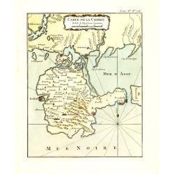
Carte de la Crimée.
Fine map of Crimea (Ukraine) here in the only issue of this version of Bellin's map, slightly larger than the common version. From Bellin's Le Petit Atlas Maritime Recuei...
Date: Paris, 1764
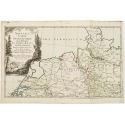
Nouvelle carte géographique des postes et autres routes d'Allemagne. . .
Map showing the northern provinces in Germany and part of the Netherlands. Decorative title cartouche in the upper left corner. A so-called post road maps.
- $80 / ≈ €70
Date: Paris, 1766
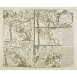
Bataille du Johansberg Gagnée par son Altesse Sérénissime Monseigneur le Prince de Condé . . . Le 30 Aoust 1762 . . .
Five detailed military battle-plans showing the four stages in the siege of Johansburg and the battle plan around Grüningen published by Jean de Beaurain (1696–1771) ....
- $150 / ≈ €131
Date: Paris, 1766
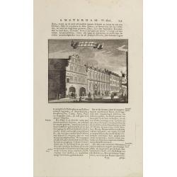
t'Oost-Indisch-Huys.
A decorative print of the East Indian House, the headquarters of the V.O.C., a place for meeting, trading and storage of spices and ship equipment. The maps and charts we...
- $150 / ≈ €131
Date: Amsterdam, 1760-1767
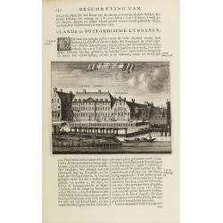
s'Lands en Oost-Indische Lynbanen.
A decorative print of the Lynbanen a place were V.O.C. ship riggings and ropes were produced and kept.From J.Wagenaar: Amsterdam in zijne opkomst, aanwas, geschiedenisse....
- $100 / ≈ €87
Date: Amsterdam, 1760-1767
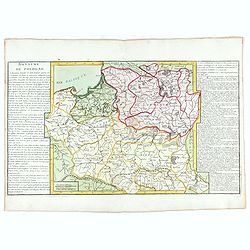
Royaume de Pologne.
Fine map of Lithuania, Prussia and Poland with an explicatif text to both sides. From Jean Baptiste Louis Clouet (1730-1790) influential "Géographie Moderne" f...
Date: Paris, ca. 1767
Carte réduite du Golphe de Genes. Conenant partie des cotes de Provence, celles de Piemont, de Genes et de Toscane . . .
Superb sea chart covering the coasts of the French and Italian Riviera's, Tuscany and northern tip of Corsica, prepared by Jacques Nicolas Bellin (1703-1772) the Royal Hy...
Date: Paris, 1768
![[manuscript plan] Siège de Schweidnitz en Silésie fait par les trouppes Imperial es commandées par Mr. le de Nadasti ...](/uploads/cache/39893-250x250.jpg)
[manuscript plan] Siège de Schweidnitz en Silésie fait par les trouppes Imperial es commandées par Mr. le de Nadasti ...
This fine manuscript shows the layout of the city of Swidnica with its surrounding defence wall, its advanced bastions and suburbs, roads and two nearby villages. In lowe...
- $2750 / ≈ €2402
Date: France, 1769
Plan général de Reims et de ses Environs Dédié au Roi.
Rare wall map of a plan of Reims engraved by Jean Lattré. Central cartouche included in the lower border, composed of the coat of arms of France and Navarre, surmounted ...
- $2500 / ≈ €2184
Date: Paris, Lattré, 1769
Tabula Geographica qua pars Russiae Magnae. . .
An unrecorded state Homann's map is based upon the works of George von Mengden (1628-1702), a Livonian cartographer who worked for Peter the Great and Count Jacob Bruce [...
Date: Nuremberg, c. 1770
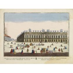
(Berlin) Prospectus Armamentarii regnii versus arcem principis regis haereditarii Berolini.
A square in Berlin. In the eighteenth and nineteenth centuries there were many popular speciality establishments in Paris, Augsburg and London which produced optical view...
- $200 / ≈ €175
Date: Italy, 1770
