Browse Listings in Europe
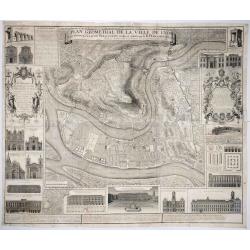
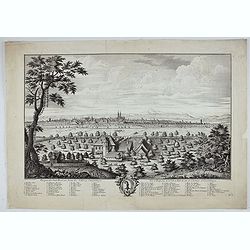
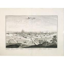
Plan Geometral de la Ville de Lyon.
A gigantic wall map of Lyon was originally issued in 1735 and revised in 1740. Engraved by Claude Seracourt and published by R.P. Grégoire in Lyon, France in 1740.This i...
Date: Lyon, ca. 1740
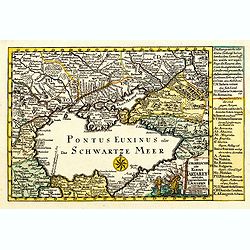
Die Europaeische oder kleine Tartarey, nebst den angraentzenden Laendern. . .
Showing the Black Sea region. Uncommon map from the "Atlas Selectus" by the German cartographer Johann Georg Schreiber (1676-1750). Schreiber followed in the fo...
- $450 / ≈ €393
Date: Leipzig, 1741
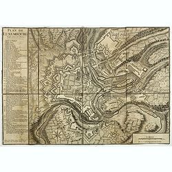
Plan de Luxembourg.
Beautiful engraved plan of the city of Luxembourg, accompanied by a table of references.
- $500 / ≈ €437
Date: Paris, 1741
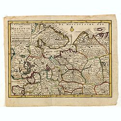
'T Noorderdeel van Moscovie Na de stelling van G. de L'Isle. . .
Attractive and rare map of part of Russia, including St. Persburg, Archangel, Finland, Lapland and Moscow. From Atlas Portatif .
- $100 / ≈ €87
Date: Deventer, 1742
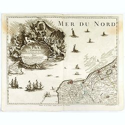
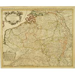
Carte des Pais Bas contenant la Flandre, le Brabant, Pais de Liege. . .
Map sheet from a multi-sheet map of the Low Countries, showing a large title cartouche and part of the Northern French coast line around Calais, Duinkerken and Furnes. Th...
- $75 / ≈ €66
Date: Paris, 1742
Rom: Keyserl. Majest. Königl Hoher Allierten Kriegs Theatrum von Schlesien, Böhmen, Maehren u: Oestereich. . .
A rare map centred on Austria, eastern Germany, Poland and Tsjechië. In upper right corner an inset plan of Prague. Showing the situation of the first Silesian War of 17...
- $900 / ≈ €786
Date: Nuremberg, 1742
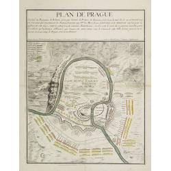
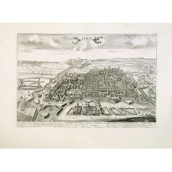
Plan de Prague.
Rare and separately published plan of Prague published by Joan Baptista Nolin with the address à l'enseigne de la Place des Victoires et chez le Sr. Humblot rue St. Jacq...
- $550 / ≈ €480
Date: Paris, ca. 1742
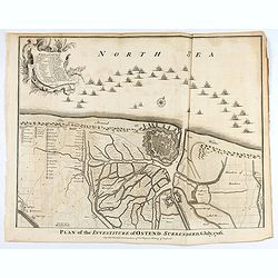
Plan of the Investiture of Ostend Surrenderd, 6 July, 1706
An interesting copper engraved plan of the Fortification of Doway in Flanders, with an attractive rococo cartouche, showing an overview of the battlefield and surrounding...
Date: London, 1743
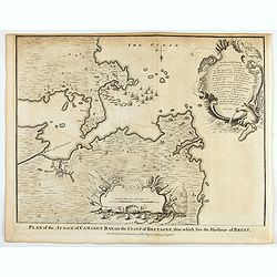
Plan of the Attack of Camaret Bay, on the coast of Bretagne, thro which lies the Harbour of Brest.
An interesting copper engraved plan of the Fortification of Camaret in Bretagne (France), with an attractive rococo cartouche, showing an overview of the battlefield and ...
Date: London, 1743
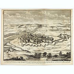
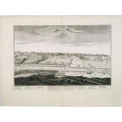
A view of Cassel, a very strong city in Italy, taken by the Duke of Savoy in Decem.r 1706
An interesting copper engraved plan of the Fortification of Cassel in Italy, with an attractive rococo cartouche, showing an overview of the battlefield and surrounding a...
Date: London, 1743
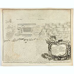
Plan of ye Battle of Wynendale between ye Troops of ye Allies commanded by Major Gen. Webb & those of France under Count de La Motte Sept. 28 1708.
An interesting copper engraved battle plan of Pinedale during the War of the Spanish Succession, showing the position of General Webb's troops in order to protect an alli...
Date: London, 1743
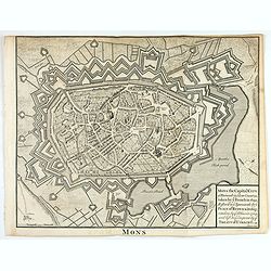
Mons the Capital City of Hainault in y Low Countries, taken by y French in 1691, Restor'd to y Spaniards by y Peace of Ryswick in 1697, retaken by y Allies in 1709, and left to y Emperor by y Treaty of Utrecht. .
An interesting copper engraved view of the walled city engraved by I. Basire, with pictographs of buildings. Many buildings and places are named on the map. Nicholas Tind...
Date: London, 1743
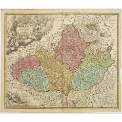
Tabula Generalis Marchionatus Moraviae..
Johann Baptist Homann's well-engraved map has a large decorative cartouche. Detailed map of the historic Moravia region of the Czech Republic, in the present-day Jihormor...
- $275 / ≈ €240
Date: Nuremberg 1744
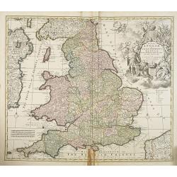
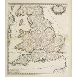
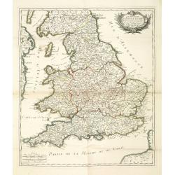
Regni Angliae et Wallae principatus Tabula, divisa in LII Regiones. . .
A detailed and decorative map of England, with an attractive uncolored title cartouche. The map is a re-issue of Carolus Allard's map. The elaborate title cartouche in th...
- $400 / ≈ €349
Date: Amsterdam c. 1744
![[2 maps and one text sheet] Theatrum Belli A° MDCCXXXVII. . . / Verus Chersonesi Tauricae Seu Crimea Conspectus adjacentium item Regionem itinerisq ab Exercitu Ruthemo...](/uploads/cache/27975-250x250.jpg)
[2 maps and one text sheet] Theatrum Belli A° MDCCXXXVII. . . / Verus Chersonesi Tauricae Seu Crimea Conspectus adjacentium item Regionem itinerisq ab Exercitu Ruthemo...
[2 maps and one text sheet] Theatrum Belli A° MDCCXXXVII. . . / Verus Chersonesi Tauricae Seu Crimea Conspectus adjacentium item Regionem itinerisq ab Exercitu Ruthemo A...
- $1100 / ≈ €961
Date: Amsterdam, c. 1744
Cours du Danube, Feuille 1 contenant LA SUABE . . .
Fine map of part of the River Danube, including the southern German province of Swaben.From his rare atlas "Theatre de la Guerre en Allemagne, contenant toutes les O...
Date: Paris, 1744
Marchionatus Moraviae circulus Hradistiensis..
Johann Baptist Homann's well-engraved map has a large decorative cartouche. Detailed map centered on Hradisch.Johann Baptist Homann (1663-1724) was a German engraver and ...
Date: Nuremberg 1744
Le royaume d'Angleterre..
Fine map of England and Wales. As well as country details, including the main post roads. Le Rouge was active from 1740- till 1780 as a publisher, and was appointed engin...
- $250 / ≈ €218
Date: Paris, 1745
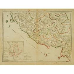
Regionum Italiae mediarum Tabula Geographica. . .
Fine historical map of central Italy with Tuscany, centered on Rome, in the south Pompeii, in the top the island of Giglio and the town Orbetello. Lower left inset plan o...
- $150 / ≈ €131
Date: Paris, 1745
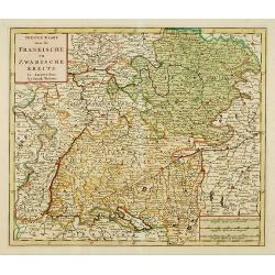
Nieuwe Kaart van de Frankische en Zwabische Kreits.
Deatailed map of the Southern part of Germany. Isaak Tirion was born in Utrecht ca. 1705. He came to Amsterdam ca. 1725. Tirion published a number of important books, m...
- $100 / ≈ €87
Date: Amsterdam, 1745
![Partie Septentrionale de la Souabe [and] Partie Meridionale de la Souabe. (2 maps)](/uploads/cache/21468-250x250.jpg)
Partie Septentrionale de la Souabe [and] Partie Meridionale de la Souabe. (2 maps)
Pair of maps forms a large, detailed view of Swabia, one of the ten circles of the Holy Roman Empire and containing some of the historically most interesting and cultural...
- $250 / ≈ €218
Date: Amsterdam c. 1745
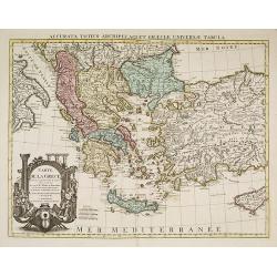
Carte de la Grece dressée sur un grand nombre de memoires. . .
Detailed copper-engraved map of Greece with its neighboring countries, including southern Italy and part of Cyprus. Relief shown pictorially. With large decorative title ...
Date: Amsterdam c. 1745
Carte Des Pays Bas Catholiques Dressée. . .
Topographically detailed map that extends from Paris to Metz and north into Holland. Details include roads and scores of villages. Two decorative cartouches: one with fig...
Date: Amsterdam, c. 1745
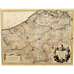
Carte du Comté de Flandre, Dressée sur differens. . .
Large, detailed map of the Flanders including the French Flemish-speaking area. Shows illustrated topography with notations about towns, roads, fortresses, abbeys, monast...
Date: Amsterdam, c. 1745
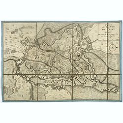
Plan de la ville de Gand. Paris, Sr. Le Rouge, 1745.
Town-plan of Ghent with its citadel, published in 1745, the year when the city was taken by the French during the War of Austrian Succession. The north is located to the ...
- $380 / ≈ €332
Date: Paris, 1745
![[Lot of 3 maps] Carte de la Souveraineté de NEUCHATEL et VALLANGIN. Plus Mercator's and Blaeu's maps of the Wiflispurgergou]](/uploads/cache/18600-250x250.jpg)
[Lot of 3 maps] Carte de la Souveraineté de NEUCHATEL et VALLANGIN. Plus Mercator's and Blaeu's maps of the Wiflispurgergou]
Map of the lake of Neuchatel by Covens & Mortier. After the death of the widow of Pieter Mortier in 1719, the firm continued till 1778 as Covens & Mortier. They...
- $350 / ≈ €306
Date: Amsterdam, c. 1745
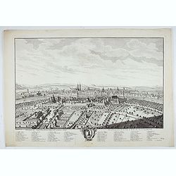
Prospect der Statt Basel von Seiten der Kleinen Statt - Vüe et Perspective de la Ville de Bâle du côté de la petite Ville.
Very decorative view of Basle, after a design by Emanuel Büchel and engraved by Johann Martin Weiss. The legend inscribed under the engraving, numbered from 1 to 10, des...
Date: Basle, 1745
Prospect der Statt Basel von Seiten der Schlösser - Vuë et Perspective de la Ville de Bale du coté des Chateaux de Gundeldingue.
Very decorative view looking towards Basel from the castle at Gundeldingen, on a hill to the south. Accompanied at the bottom by a cartouche containing the arms of the ci...
Date: Basle, ca. 1745
Prospect der Statt Basel von der St Alban Vorstraat - Vu¨e et perspective de la ville de Bâle du côté du Faubourg de St Albon.
Very decorative view of Basel, after a design by Emanuel Büchel and engraved by Johann Martin Weiss. Numbered 'No.1' in the bottom right, from a rare series of 4 sheets.
Date: Basle, ca. 1745
Le royaume d'Angleterre divise en comtez et baronnie. . .
Beautiful map of England, published by le Rouge.
Date: Paris,1745
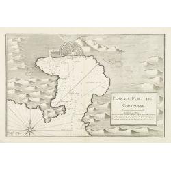
Plan du Port de Cartagene.
Sea chart of the Port of Cartagene. Marked with navigational notes.From the rare chart book by Jacques Ayrouard: Recueil de plusieurs Ports de la Mer Méditerranée...
- $200 / ≈ €175
Date: Marseille, 1732-1746

Plan du Golfe et des Caps de St. Tropez. par Jacques Ayrouard . . .
Large plan of the harbour St. Tropez. Decorated with a large compass rose.From the rare chart book by Jacques Ayrouard: "Recueil de plusieurs plans des ports et rade...
Date: Marseille, 1732-1746
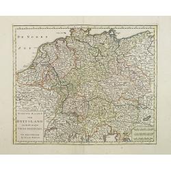
Nieuwe Kaart van Duitsland..
Detailed map of Germany, including The Netherlands, Belgium, Luxembourg, Switzerland and Austria. Isaac Tirion was born in Utrecht ca. 1705. He came to Amsterdam ca. 1725...
- $120 / ≈ €105
Date: Amsterdam, 1747
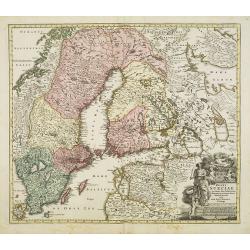
Regni Sueciae. . .
Johann Baptist Homann's well-engraved map has a large decorative cartouche. Detailed map of Sweden and Finland.Johann Baptist Homann (1663-1724) was a German engraver and...
Date: Nuremberg, 1747
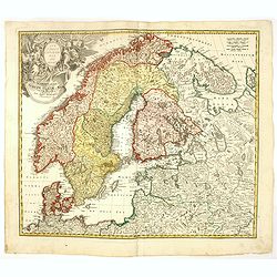
Regni Sueciae in omnes suas Subjacentes Provincias accurate divisi Tabula Generalis. . .
Johann Baptist Homann's well-engraved map has a large decorative cartouche. Detailed map of Scandinavia, the Baltic Sea, Lithuania, Latvia, Estonia, Curlandia, etc.Johann...
Date: Nuremberg, 1747
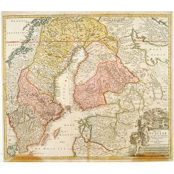
Scandinavia complectens Sueciae, Daniae & Norvegia. . .
Johann Baptist Homann's well-engraved map has a large decorative cartouche. Detailed map of Scandinavia.Johann Baptist Homann (1663-1724) was a German engraver and publis...
- $350 / ≈ €306
Date: Nuremberg, 1747
A Map of the Rout which Hannibal took through Gaul & over the Alpes into Italy.
A map showing the (clear) route the North African, Carthaginian General Hannibal took to get from Spain to northern Italy, via France and the Alps. Ancient, Latin names a...
Date: London, 1747
Regni Bohemiae, Duc. Silesiae, Marchionatuum Moraviae et Lusatiae. . .
Johann Baptist Homann's well-engraved map including the towns of Prague, Poznan/ Loda, Wroclaw, etc.This example was printed from plate A (1st of 3), which can be identif...
- $200 / ≈ €175
Date: Nuremberg, ca. 1748
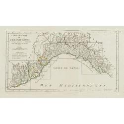
Carte Générale de l'Etat de Gênes.
Detailed map centered on the Gulf of Genoa. It shows the Italian region Liguria and extends westwards as far as Nice.Key map for the nine large-scale maps de Vaugondy mad...
- $100 / ≈ €87
Date: Paris, ca. 1748
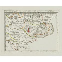
VI. Carte du Duché de Limbourg où sont les environs de Limbourg.
Attractive small map showing part of the Wallon region, centered on Limburg. Dated 1748. From Atlas Portatif Universel, by Robert de Vaugondy.Page 15f outside border top ...
- $45 / ≈ €39
Date: Paris, 1748
V. Carte du Brabant ou se trouvét les Mair.s d'Herentals.. Hochstraten.
Nice small map illustrating the northeastern part of the Flemish region. Centered on Turnhout.From Atlas Portatif Universel, by Robert de Vaugondy. Unrecorded state with ...
- $50 / ≈ €44
Date: Paris, later than 1748
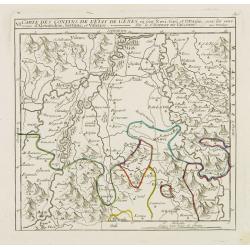
VI. Carte des Confins de l'Etat de Gênes où sont Novi, Gavi, et Ottagio..
Detailed small map encompassing the part of Piedmont between Alessandria, Tortona and Novi Ligure.Relief shown pictorially. From Atlas Portatif Universel, by Robert de Va...
- $150 / ≈ €131
Date: Paris, later than 1748
![VIII. Carte de l'Etat de Genes [. . .] Toscane.](/uploads/cache/24551-250x250.jpg)
VIII. Carte de l'Etat de Genes [. . .] Toscane.
Detailed small map showing an area straddling the provinces of Genoa, La Spezia, Parma and Massa Carrara, Tuscany.Relief shown pictorially. From Atlas Portatif Universel,...
Date: Paris, later than 1748
![[X.] Carte du Brabant où sont les environs de Tillemont, de Judoigne, de Gemblours &c.](/uploads/cache/24690-250x250.jpg)
[X.] Carte du Brabant où sont les environs de Tillemont, de Judoigne, de Gemblours &c.
Nice small map straddling the Flemish and the Walloon regions. Extending North to South from Tienen to Gembloux.From Atlas Portatif Universel, by Robert de Vaugondy. Unre...
- $30 / ≈ €26
Date: Paris, later than 1748
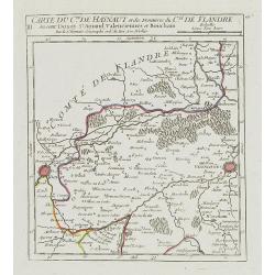
III. Carte du C.té de Haynaut et des Frontieres du C.té de Flandre..
Attractive small map encompassing part of the Nord, between Douai and Valenciennes.From Atlas Portatif Universel, by Robert de Vaugondy.Unrecorded state with erased date....
Date: Paris, after 1748
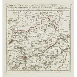
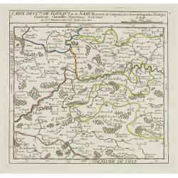
VI. Carte du C.té de Namur où sont les environs de Namur.. Huy.
Attractive small map illustrating part of the Walloon Region, between Namur and Huy. From Atlas Portatif Universel, by Robert de Vaugondy.Unrecorded state with erased dat...
- $50 / ≈ €44
Date: Paris, after 1748
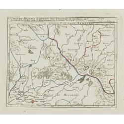
V. Carte des C.tes de Haynaut et de Namur. . .
Attractive small map illustrating part of the Walloon Region, centered on Charleroi. From Atlas Portatif Universel, by Robert de Vaugondy.Unrecorded state with erased dat...
- $30 / ≈ €26
Date: Paris, after 1748
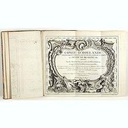
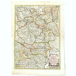
Comté d'Hollande, seigneurie d'Utrecht, comtés de Zelande, de Zutphen et duché de Brabant &c. Dressés sur les Mémoires faits par ordre des Estats Généraux et augmentés sur les Observations nouvelles.
Pocket atlas illustrated with a folded engraved title, a general map and 34 folded maps, including maps of the Netherlands, Belgium and parts of Germany.Provenance : Ex-l...
- $2400 / ≈ €2097
Date: Paris, Crépy, ca. 1748
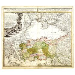
Carte de L'Asie Mineure ou de la Natolie et du Pont Euxin
Johann Baptist Homann's well-engraved map of Asia Minor, the Black Sea ( Ponti Euxin), Crimea and a part of Greece. Depicts Turkey and the area surrounding the Black Sea ...
Date: Nuremberg, ca. 1748
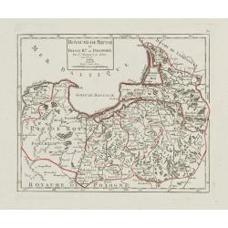
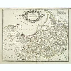
Royaume de Prusse et Prusse Rle. ou Polonoise.
On the left is Pomerania and the Desert of Waldow. At the top of the map is Memel and Samland. On the right side is the Biss River and Kautten. In the center of the map i...
- $125 / ≈ €109
Date: Paris, later than 1749
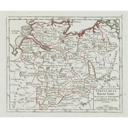
Cercle de la Basse Saxe, divisée par ses Principautés.
Small detailed map of the northern part of Germany. From Atlas Portatif Universel, by Robert de Vaugondy.Unrecorded state with erased date. Page 22 outside border top rig...
- $50 / ≈ €44
Date: Paris, later than 1749
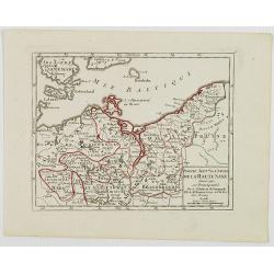
Partie Sept.le du Cercle de la Haute Saxe divisé par ses Principautés.
Small detailed map of the northeastern part of Germany, with Berlin at the bottom. Including part of Poland. From Atlas Portatif Universel, by Robert de Vaugondy.Unrecord...
- $75 / ≈ €66
Date: Paris, later than 1749
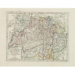
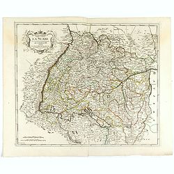
Les Suisses, les Alliés des Suisses et leurs Sujets.
Small detailed map of Switzerland. From Atlas Portatif Universel, by Robert de Vaugondy.Unrecorded state with erased date. Page 31 outside border top right. Mary Sponberg...
Date: Paris, later than 1749
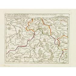
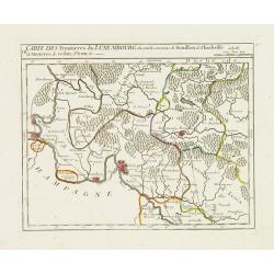
I. Carte du D.ché de Luxembourg ou sont les Frontieres du Namurois et du Lyegeois.
Charming small map representing part of the Walloon Region, delimited by the towns of Namur, Huy, Dinant and Ciney.From Atlas Portatif Universel, by Robert de Vaugondy. E...
Date: Paris, later than 1749
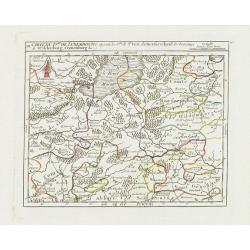
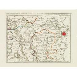
II. Carte du D.é de Luxembourg.. Seign.rie de Lyege &c.
Charming small map representing part of the Walloon Region, south to Liège. From Atlas Portatif Universel, by Robert de Vaugondy.Edited by : "Au dépôt de Géograp...
Date: Paris, later than 1749
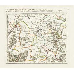
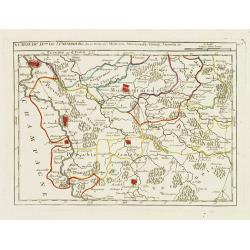
III. Carte du D.hé de Luxembourg.. Cronenburg &c.
Charming small map representing part of the Walloon Region, southeast to Limburg. From Atlas Portatif Universel, by Robert de Vaugondy.Edited by : "Au dépôt de Gé...
Date: Paris, later than 1749
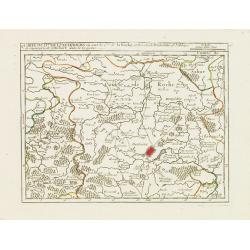
IV. Carte du Duché de Luxembourg où sont les Seign.ries de Lompré..
Charming small map representing part of Luxembourg, the southernmost province of Wallonia and of Belgium.From Atlas Portatif Universel, by Robert de Vaugondy. Edited by :...
Date: Paris, later than 1749
V. Carte du D.hé de Luxembourg.. dans le Lyegeois.
Charming small map representing part of Luxembourg, the southernmost province of Wallonia and of Belgium. Centered on Bastogne.From Atlas Portatif Universel, by Robert de...
Date: Paris, later than 1749
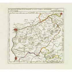
VII. Carte des Frontieres du Luxembourg.. Yvoix &c.
Detailed small map showing an area straddling the border between France and Belgium.From Atlas Portatif Universel, by Robert de Vaugondy. Edited by : "Au dépôt de ...
Date: Paris, later than 1749
IX. Carte du D.ché du Luxembourg.. Diekirch &c.
Charming small map representing the area between Luxembourg and Trier. From Atlas Portatif Universel, by Robert de Vaugondy.Edited by : "Au dépôt de Géographie, R...
Date: Paris, later than 1749
X. Carte du D.ché de Luxembourg.. Jametz &c.
Nice small map encompassing the northwestern part of Lorraine. Showing Mouzon, Stenay, Montmedy..From Atlas Portatif Universel, by Robert de Vaugondy. Edited by : "A...
Date: Paris, later than 1749
![[IX.] Carte du Brabant ou sont les Mairies de Roo, de Nivelle, de Hulpen, et de Geneppe.](/uploads/cache/24689-250x250.jpg)
[IX.] Carte du Brabant ou sont les Mairies de Roo, de Nivelle, de Hulpen, et de Geneppe.
Nice small map straddling the Flemish and the Walloon regions. It shows Halle, Nivelles, La Hulpe, Overijse, Genappe, etc.From Atlas Portatif Universel, by Robert de Vaug...
Date: Paris, later than 1749
Estats du Grand duc de Moscovie ou de l'Empereur de la Russie Blanche.
Uncommon map of European Russia centered on Muscovy. Charming title cartouche in upper right corner.
- $300 / ≈ €262
Date: Amsterdam, ca 1749
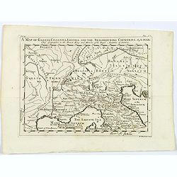
A Map of Gallia, Cisalpina, Liguria and the Neighbouring Countries.
A map of eastern France, Provence, northern Italy, then to Tuscany, whilst also showing northern Switzerland and Bavaria in Roman times. Showing Roman Provinces, a mileag...
Date: London, ca 1749
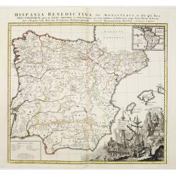
Hispania Benedictina, seu Monasteria et alia pia loca Ord. S. Benedicti ..
Map of the Iberian Peninsula and an inset map of South America with all the monasteries and holy places of the Benedictine order, compiled by the Benedictine friar Rupert...
Date: Nuremberg 1750
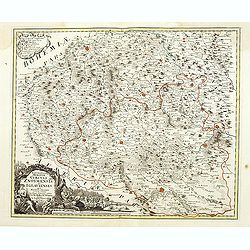
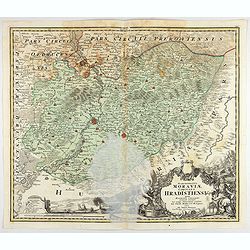
Marchionatus Moraviae circuli Znoymensis et Iglaviensis. . .
Map of the Znaym region of Moravia, the southern part of the Czech Republic, with figurative cartouche and small table of explanations. After Johann Christoph Müller pub...
- $250 / ≈ €218
Date: Nuremberg, 1750
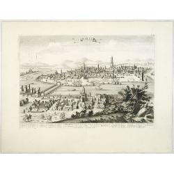
Naples, Ville de la Province de Labour, Archiépiscopale, et Capitale du Royaume de Naples.
A very decorative and extremely rare view of Naples, including a numbered (1-18) key in the lower part. Published by Jacques Chéreau, (1688 - 1776). Engraved by Aveline ...
- $3500 / ≈ €3057
Date: Paris, ca.1750
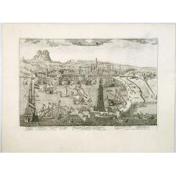
Seville. Ville Archiepiscopale et Capitale du Raume d'Andalousie en Espagne. . .
A very decorative and extremely rare view of Seville, including a numbered (1-37) key in the lower part. Published by Jacques Chéreau, (1688 - 1776). Engraved by Aveline...
- $2200 / ≈ €1922
Date: Paris, ca.1750
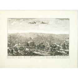
Messine. Anciennement Messena Ville . . .
A very decorative and extremely rare view of Messina on Sicily, including a numbered (1-16) key in lower part. Published by Jacques Chéreau, (1688 - 1776). Engraved by A...
- $3000 / ≈ €2621
Date: Paris, ca.1750
Barcelone, Ville Capitale de la principauté Catalogne. . .
A very decorative and scarce view of Barcelona, including a numbered key ( 1-29 ) in the lower part. Published by Jacques Chéreau, (1688 - 1776). Engraved by Aveline and...
- $4000 / ≈ €3494
Date: Paris, ca.1750
Rome. Profil de la Ville de Rome.
A very decorative and extremely rare town view of Rome, including a numbered key ( 1-47 ), in lower part. The Vatican with St.Pierre in the left, with great detail. Publ...
- $3300 / ≈ €2883
Date: Paris, ca.1750
Milan. Ville forte, Capitale du Duché de même nom, l'une des plus grandes des des plus considérables de l'Italie.
A very decorative and extremely rare of Milan, including a numbered key ( 1-35 ) in lower part. Published by Jacques Chéreau, (1688 - 1776). Engraved by Aveline and fir...
- $3500 / ≈ €3057
Date: Paris, ca.1750
Turin. Ville Capitale du Piemont et Residence du Duc de Savoye Roy de Sardigne.
A very decorative and extremely rare town-view of Turin, including a numbered key ( 1- 28 ) in lower part. Published by Jacques Chéreau, (1688 - 1776). Engraved by Pierr...
- $2500 / ≈ €2184
Date: Paris, ca.1750
Madrid Villa Capital Del Reyno D'Espana.. / Madrid ville capitale du Royaume d'Espagne . . .
A very decorative and scarce town view of Madrid, including a numbered key ( 1-17 ) in Spanish and French in the lower part. Published by Jacques Chéreau, (1688 - 1776)....
- $3300 / ≈ €2883
Date: Paris, ca.1750
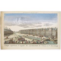
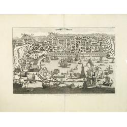
Colléges impériaux et magasin des marchandises de l'Orient, à St. Pétersbourg.
Showing a busy scene at the international trading grounds of 18th century Saint Petersburg, showing the warehouses of the different international trading companies. J. Ch...
- $200 / ≈ €175
Date: Paris, ca. 1750
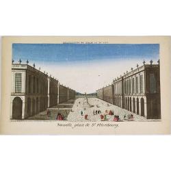
Nouvelle place de St. Pétersbourg.
Showing a square at 18th century Saint Petersburg. J. Chereau was a publisher of optical prints, established in Paris, rue St.Jacques.In the eighteenth and nineteenth ce...
- $200 / ≈ €175
Date: Paris, ca. 1750

Arc de Triomphe ou se passe la proscription d'Octave et d'Antoine.
J. Chereau was a publisher of optical prints, established in Paris, rue St.Jacques.In the eighteenth and nineteenth centuries, there were many popular specialty establish...
- $200 / ≈ €175
Date: Paris, ca. 1750
La Prusse divisée en Prusse royale, et Prusse Ducale. . .
Finely and crisply engraved map of Prussia including The Bay of Danzig. Ornamental title cartouche in the upper part of the map from his "Atlas Universel".Gille...
- $300 / ≈ €262
Date: Paris, 1750
Principatus Halberstadiensis, abbat : Quedlinburgens cum Comitatu Wernigerodano, ad hodiernum verum statum ex acta prodiit ex officina geogr. . .
Detailed map showing principality Halberstadt, Abtei Quedlinburg and the county Wernigerode. Including the towns of Osterwieck, Stollberg, Aschersleben and Oschersleben.
Date: Augsburg, 1750
Electoratus saxonici praefecturae annaburgensis pretzschens torgaviensis schweinicensis. . .
Highly detailed map showing the regions of Annaburg, Pretzsch, Schweinitz in Sachsen-Anhalt, Torgau in Sachen and Mühlberg an der Elbe in Brandenburg. In the center of t...
Date: Augsburg, 1750
