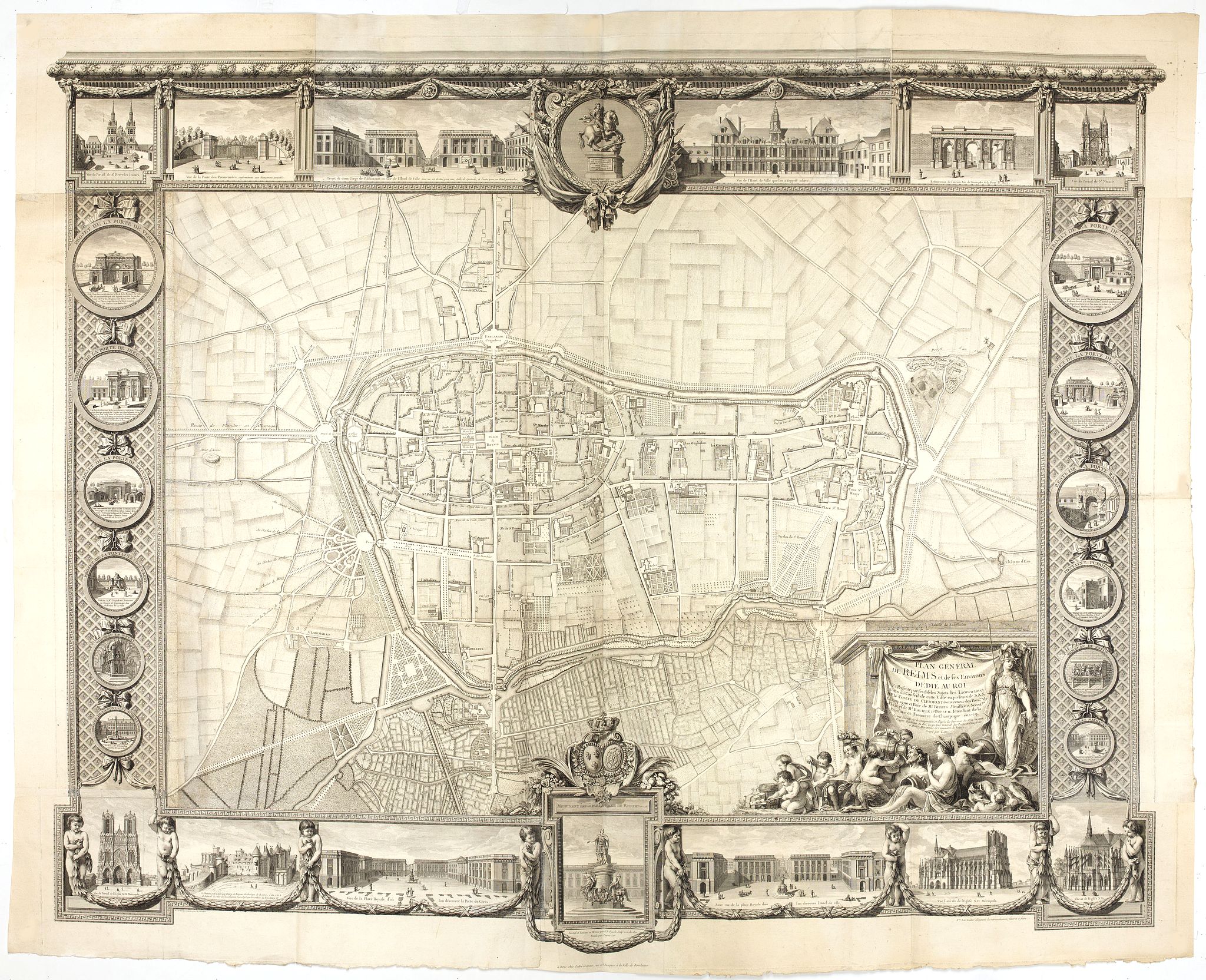
1769 LEGENDRE, Jean-Gabriel. - Rare wall map of a plan of Reims, engraved by Jean Lattré.
Plan général de Reims et de ses Environs Dédié au Roi.
| Maker: | LEGENDRE, Jean-Gabriel. | |
| Date: | Paris, Lattré, 1769 | |
| Colored: | Uncolored. | |
| Size: | 1110 x 1410 mm / 43.7 x 55.5 inches | |
| Condition: | Wall map in two sheets accompanied by borders in 7 boards engraved separately. The plan if joined, without the borders is 820 x 1140 mm. | |
 Add/Remove this item to MyCollection+




Description
Behind him, Romulus and Remus stand against the Roman wolf (according to legend, the city of Reims was founded by Remus). On the ancient monument "Scale of 300 toises".
The map is placed in an illustrated frame of 26 medallions engraved by C.R.J. Poulleau, showing the monuments of the city: the gates and fountains, including the gate of Mars and the ones of the walks, the churches Saint Nicaise and Notre Dame, the royal square, and several monuments now missing (the church of Saint Peter the Ladies, the castle of the archbishops, the city hall "which was supposed to be completed", the project of two buildings opposite the city hall).
This plan of the architect Jean-Gabriel Legendre, engineer of the king assigned to the province of Champagne, takes again the vast project of embellishment of the city which he had conceived. This project also provided, in addition to the development of the royal square and public walks, the alignment of several streets, the clearing of the approaches to the cathedral, and the transformation of several city accesses.
This plan exists in two versions with a slightly different title: "General Plan of the City of Reims" and "General Plan of Reims and its Surroundings", sometimes with an added border. The plan presented is titled "General Plan of Reims and its Surroundings" and includes its border.
Dare to go in Black. Early maps were printed in black and white; many stayed that way for a long time. A black-and-white map with such a strong impression is a rarity nowadays, as so many have been colored in recently! ¤
Read more [+]
Wall Maps
Wall maps were found in the interiors of wealthy businessmen. Wall maps occupied a prominent place in contemporary Dutch culture, serving as icons of affluence and intellectual curiosity.One of the leading lights of the era, Constantijn Huygens (1596-87), remarked how he employed his own set of Blaeu's wall maps of the continents as a tool to enlighten his children: "To encourage them even more, I had the four parts of the world by Willem Blaeu mounted in my entrance hall, where they often played, in order to provide them with a fixed image of the world and its division."
Willem Blaeu's wall maps are considered among the most influential and artistically virtuosic masterpieces of the great era of baroque cartography. His enterprise maintained close connections with intellectuals and political leaders across Europe, granting him privileged access to the most advanced geographical knowledge. Evidence of their fame may be their appearance in several of Johannes Vermeer's paintings.
A striking feature of the relatively small number of paintings that comprise the oeuvre of Johannes Vermeer is the prominent place accorded to maps and globes. Maps used as wall hangings in contemporary Dutch houses served purposes beyond providing cartographic information. Maps also expressed status, promoted a better understanding of history or politics, or replaced paintings. When Vermeer painted his works, Amsterdam was the world center of map-making. Among the most impressive works were Willem Blaeu's wall maps.
The pride-of-place wall maps in Dutch homes appear most clearly in a half-dozen or so of Vermeer's exquisite paintings, as well as in contemporary scenes such as Pieter de Hooch's A Woman Drinking with Two Men (1658) in the National Gallery. These views of everyday life bear witness to an almost totemic cult of maps.
Soon, libraries and the offices of the wealthy and nobility across Europe had wall maps. Wall maps also hung in many places in America in the eighteenth century, for instance, in the Governor's Palace in Williamsburg, Virginia.
By the nineteenth century, Americans used wall maps throughout the Country. They hung in government offices, public meeting places, schools and in some homes. Early on in the century, wall maps showed the expanding country, with its natural features and political divisions, roads, canals and then railroads. Because these maps were designed for practical use and their large format made detailed study easier, map makers updated them regularly to keep them as current and accurate as possible.
FAQ - Guarantee - Shipping
Buying in the BuyNow Gallery
This item is available for immediate purchase when an "Add to Cart" or "Inquire Now" button is shown.
Items are sold in the EU margin scheme.
Payments are accepted in Euros or US Dollars.
Authenticity Guarantee
 We provide professional descriptions and a condition report (based on 45 years experience in the map business).
Paulus Swaen warrants the authenticity of our items and a certificate of authenticity is provided for each acquired lot.
Condition and Coloring
We indicate the condition of each item and use our unique HiBCoR grading system in which four key items determine a map's value:
Historical Importance, Beauty, Condition/Coloring and Rarity.
We offer many maps in their original black and white condition. We do not systematically color-up maps to make them more sellable to the general public or buyer.
Copper engraved or wood block maps are always hand colored. Maps were initially colored for aesthetic reasons and to improve readability.
Nowadays it is becoming a challenge to find maps in their original colors, and these are therefore more valuable.
We use the following color keys in our catalog:
- Original colors: the colors were applied around the time the map was issued.
- Original o/l colors: only the borders were colored at the time of publication.
- Colored: the colors were applied recently or at the end of the 20th century ("attractive colors" may also be used).
Read more about coloring of maps [+]
Shipping fee
A flat shipping fee of $30 is added to each shipment by DHL within Europe and North America. This covers international priority shipping, packing and insurance (up to the invoice amount).
Shipments to Asia are $40 and rest of the world $50.
We charge only one shipping fee when you have been successful on multiple items or when you want to combine gallery and auction purchases.
Read more about invoicing and shipping
FAQ
Please have a look for more information about buying in the BuyNow gallery.
Many answers are likely to be found in the general help section.
MyCollection+

With MyCollection+ you can collect all your favorite items in one place. It is free, and anyone can create his or her virtual collection.
Unless you are logged in, the item is only saved for this session. You have to be registered and logged in if you want to save this item permanently.
Read more [+]
Register here, it is free and you do not need a credit card.
Add this item to
MyCollection+
or see MyCollection+.
Paulus Swaen maintains an archive of most of our high-resolution rare maps, prints, posters and medieval manuscript scans.
We make them freely available for download and study.
Read more about free image download
Click the image for a free small image download.
YOUR RIGHT TO CANCEL THE PURCHASE OF A LOT
In accordance with the EU Consumer Rights Directive and habitually reside in the European Union you have the right to cancel the contract for the purchase of a lot, without giving any reason.
The cancellation period will expire 14 calendar days from the day after the date on which you or a third party (other than the carrier and indicated by you) acquires, physical possession of the lot. To exercise the right to cancel you must inform Paulus Swaen Inc, of your decision to cancel this contract by a clear statement (e.g. a letter sent by post, or e-mail.
To meet the cancellation deadline, it is sufficient for you to send your communication concerning your exercise of the right to cancel before the cancellation period has expired.
