Sign In or Sign Up
1769 RUEL de BELLISLE, N.Th. - [manuscript plan] Siège de Schweidnitz en Silésie fait par les trouppes Imperial es commandées par Mr. le de Nadasti ...
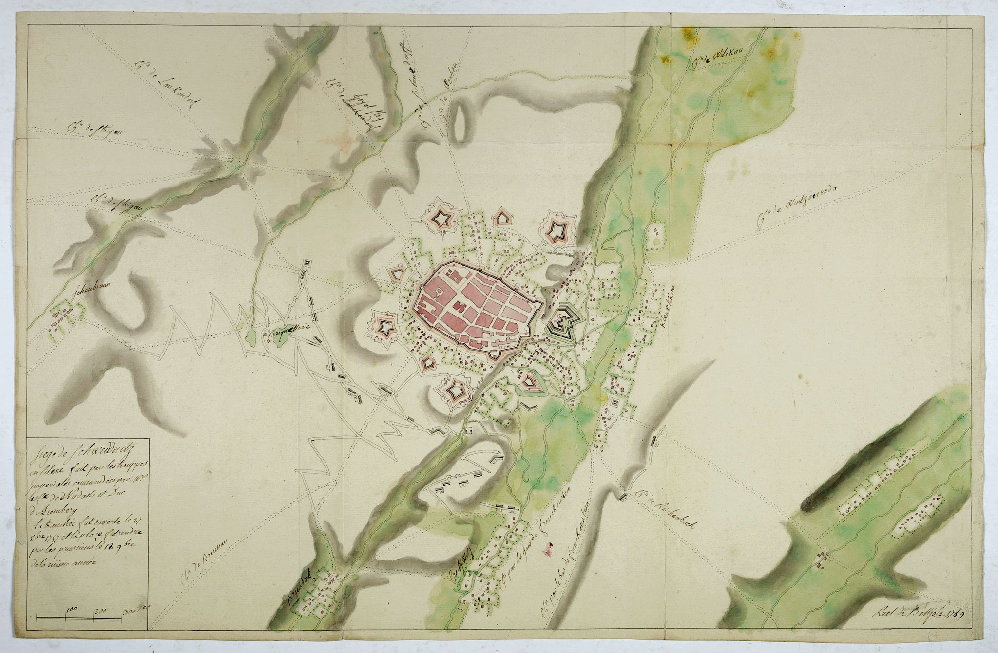
[manuscript plan] Siège de Schweidnitz en Silésie fait par les trouppes Imperial es commandées par Mr. le de Nadasti ...
| Maker: | RUEL de BELLISLE, N.Th. | |
| Date: | France, 1769 | |
| Colored: | In original colors. | |
| Size: | 372 x 582 mm / 14.6 x 22.9 inches | |
| Condition: | Manuscript map on thick paper, brown ink and watercolor, showing the fortified city Schweidnitz (today Swidnica) in Silesia in the Polish region of Lower Silesia. The drawing is signed and dated by Nicolas-Tbomas de Ruel de Bellisle, 1769. | |
-This item is available for immediate sale
$2750 / ≈ €2456





Description
This fine manuscript shows the layout of the city of Swidnica with its surrounding defense wall, its advanced bastions and suburbs, roads, and two nearby villages. In the lower right, along the Bystrzyca River.
The plan indicates the positions of the Austrian imperial army under the command of Nadasdy, besieging the town.
The title in the lower left corner also mentions “que “la tranchée fut ouverte le 27 8bre 1757 et la place fut rendue par les Prussiens le 12 9bre de la même année”.
In 1757, at the beginning of the Seven Years' War, Austria tried to take over the rich province of Silesia from Prussia, which was conquered in 1742. The Austrian army captured the town of Schweidnitz in December 1757 but lost it the following year.
The plan is dated 1769 and signed Ruel de Bellisle lower right.
The scale is in “toises”, the relief is marked by shadows. On the verso of the plan is the title "Allemagne Siège de Schweidnitz fait par les impériaux en 1757”. < br>< br>Nicolas-Tobias de Ruel de Bellisle was a Captain in the Corps of Royal Engineers and a member of the Nobility of Normandy (France).
The fortress of Swidnica is located at an important crossroads linking Breslau, Glatz, Landeshut and the axis Bunzelwitz-Striegau-Liegnitz. Frederick II improved the town from 1747 to 1756 through a continuous series of works. The works were finished just for the outbreak of the Seven Years' War. Outer works were added to the walls dating from previous periods. Some of these outer works were as far as 500 m. from the city walls. The concept was new and revolutionary. It relied on defensive zones that took advantage of the lay of the land in front of the works and created areas of crossfire.
This approach was an innovation compared to Vauban's theory, which based defense on a continuous rampart and completely dictated the dispositions of the outworks. Developed by the same Frederick, this brilliant innovation, often copied in the military architecture of the XVIIIth century, allowed for a more economical use of fortifications without the huge dispersion of manpower and artillery necessary to defend the extensive perimeter of a city, and the vast construction and maintenance expenses.
The Austrians, who eventually became masters of the fortress, did not really grasp the modernity of its structures and linked the outworks with field works to constitute continuous fortifications.
Franz Leopold von Nádasdy auf Fogaras (1745-1763), was an Austrian General of Cavalry. On September 7, Nádasdy led the successful attack on an isolated Prussian corps in the Battle of Moys. Finally, on November 13, after besieging Schweidnitz for only 16 days, he captured this important fortress. On December 5 at the Battle of Leuthen, Nádasdy led the cavalry of the Austrian left wing. He faced biased reports about his conduct during the battle and never assumed command again for the rest of the war.
FAQ - Guarantee - Shipping
This item is available for immediate purchase when a "Add to Cart" or "Inquire Now" button is shown.
Items are sold in the EU margin scheme
Payments are accepted in Euros or US Dollars.
Authenticity Guarantee
 We provide professional descriptions, condition report (based on 45 years experience in the map business)
Paulus Swaen warrants the authenticity of our items and a certificate of authenticity is provided for each acquired lot.
Condition and Coloring
We indicate the condition of each item and use our unnique HiBCoR grading system in which four key items determine a map's value: Historical Importance, Beauty, Condition/Coloring and Rarity.
Color Key
We offer many maps in their original black and white condition. We do not systematically color-up maps to make them more sellable to the general public or buyer.
Copper engraved or wood block maps are always hand colored. Maps were initially colored for aesthetic reasons and to improve readability. Nowadays, it is becoming a challenge to find maps in their original colors and are therefor more valuable.
We use the following color keys in our catalog:
Original colors; mean that the colors have been applied around the time the map was issued.
Original o/l colors; means the map has only the borders colored at the time of publication.
Colored; If the colors are applied recently or at the end of the 20th century.
Read more about coloring of maps [+]
Shipping fee
A flat shipping fee of $ 30 is added to each shipment by DHL within Europe and North America. This covers : International Priority shipping, Packing and Insurance (up to the invoice amount).
Shipments to Asia are $ 40 and rest of the world $50
We charge only one shipping fee when you have been successful on multiple items or when you want to combine gallery and auction purchases.
Read more about invoicing and shipping
FAQ
Please have a look for more information about buying in the BuyNow gallery
Many answers are likely to find in the general help section.
MyCollection+

With My Collection+ you can collect all your favorite items in one place. It is free, and anyone can create his or her virtual collection.
Unless you are logged in, the item is only saved for this session. You have to be registed and logged-in if you want to save this item permanently to My Collection+. Read More[+]
Register here, it is free and you do not need a credit card.
Add this item to My Collection+ or click the following link to see My Collection+.
|
Digital Image Download Paulus Swaen maintains an archive of most of our high-resolution rare maps, prints, posters and medieval manuscript scans. We make them freely available for download and study. Read more about free image download |
Click the image for a free small image download. |
YOUR RIGHT TO CANCEL THE PURCHASE OF A LOT
In accordance with the EU Consumer Rights Directive and habitually reside in the European Union you have the right to cancel the contract for the purchase of a lot, without giving any reason.
The cancellation period will expire 14 calendar days from the day after the date on which you or a third party (other than the carrier and indicated by you) acquires, physical possession of the lot. To exercise the right to cancel you must inform Paulus Swaen Inc, of your decision to cancel this contract by a clear statement (e.g. a letter sent by post, or e-mail.
To meet the cancellation deadline, it is sufficient for you to send your communication concerning your exercise of the right to cancel before the cancellation period has expired.
Recently Viewed
[manuscript plan] Siège de Schweidnitz en Silésie fait par les trouppes Imperial es commandées par Mr. le de Nadasti ...
1769 RUEL de BELLISLE, N.Th. - [manuscript plan] Siège de Schweidnitz en Silésie fait par les trouppes Imperial es commandées par Mr. le de Nadasti ...
Date: France, 1769
