Browse Listings in Europe
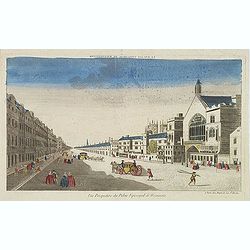
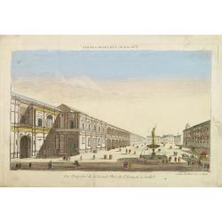
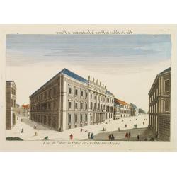
Vue perspective du palais episcopal de Westminster.
So-called optical print illustrating a perspective view of the old Palace of Westminster where the Lords and Commons met and the square facing it.. Published by Jacques C...
- $150 / ≈ €131
Date: Paris, ca. 1750
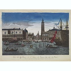
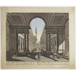
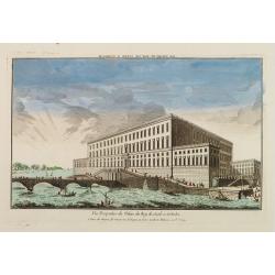
Vue de la Place de St Marc de Venise du côté du port.
Optical print showing the Doge's Palace (Palazzo Ducale), San Marco Square, and Saint Mark's Basilica (Basilica di San Marco in Venice, as seen from the waterside. The im...
Date: Paris, ca. 1750
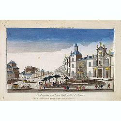
Vue perspective de la prison royale de Madrid en Espagne . . .
So-called optical print of the Royal Prison, now the Ministry of Foreign Affairs in Madrid. Published by Jacques Chereau, who was a well-known publisher of optical prints...
- $200 / ≈ €175
Date: Paris, ca. 1750
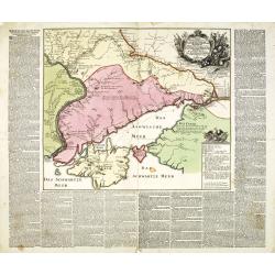
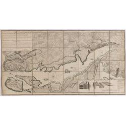
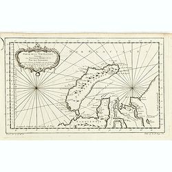
Charte der Kriegs Operationen am Donn u: Dnieper Ihro Russisch Kayserl Majestaet Glorieusen Armeen A: 1736.
Very rare separately published map of the southern part of Ukraine, with an explanatory key A-N in the lower right. The map is surrounded by letterpress German text givin...
Date: Augsburg, 1750
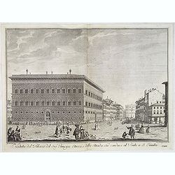
Vue de l'Entree de la Cour.. de la rue de l'Arno a Florence
So-called optical print of Arno Street in Florence, in Tuscany region. Probst was the best-known publishers of optical prints, established in Augsburg.In the eighteenth ...
- $150 / ≈ €131
Date: Augsburg 1750
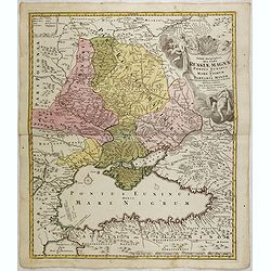
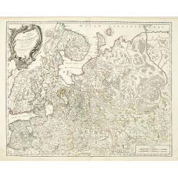
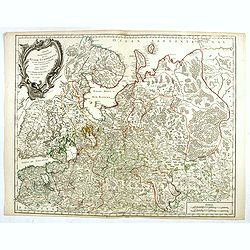
Tabula Geographica qua pars Russiae Magnae. . .
Homann's map is based upon the works of George von Mengden (1628-1702), a Livonian cartographer who worked for Peter the Great and Count Jacob Bruce [Graf Jakov Villimovi...
Date: Nuremburg, after 1750
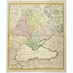
Tabula Geographica qua pars Russiae Magnae Pontus Euxinus seu Mare Nigrum et Tartaria Minor.
Homann's map is based upon the works of George von Mengden (1628-1702) a Livonian cartographer who worked for Peter the Great and Count Jacob Bruce [Graf Jakov Villimovic...
- $750 / ≈ €655
Date: Nuremburg, after 1750
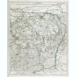
Le Brabant. Ou la Campagne du Roy de 1746. . .
Uncommon map of Dutch and Belgium Brabant by George Louis Le Rouge, who was active from 1740- till 1780 as a publisher and was appointed engineer for the King of France.D...
- $300 / ≈ €262
Date: Paris, ca. 1750
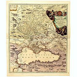
Tabula Geographica qua pars Russiae Magnae Pontus Euxinus seu mare Nigrum et Tartaria Minor cum finitimis Bulgariae, et Romaniae et Natoliae. . .
Homann's map is based upon Beauplan's general map of Ukraine but depicts the political changes of the preceding years. Shows Constantinople. Extends north to Moscow and S...
Date: Nuremburg, 1750
Imperium Moscoviae.
Map of the empire of Moscovia
- $300 / ≈ €262
Date: Nuremberg, 1750
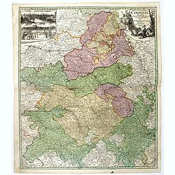
Tabula Geographica Campaniae. . .
Map of the Champagne region with Rheims, Châlons, Vitry in the center. In upper left corner two inset views with the towns of Reims et Troyes.
- $225 / ≈ €197
Date: Nuremberg, ca. 1750
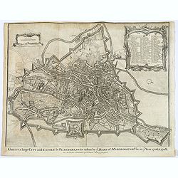
Ghent a large City and Castle in Flanders. . .
A very fine bird's-eye plan of the city and fortifications of Ghent and the surrounding countryside in Belgium. A decorative cartouche encloses a detailed key to the map ...
- $100 / ≈ €87
Date: London, ca 1750
![Plan de Mons ville capitale du comté de Haynaut. [MONS]](/uploads/cache/39799-250x250.jpg)
Plan de Mons ville capitale du comté de Haynaut. [MONS]
Charming little plan of the city of Mons in Belgium, engraved by Inselin, with a lettered key (A-V) in lower right corner.
Date: Paris, 1750
![La ville et citadelle d'Anvers. [Antwerp]](/uploads/cache/39843-250x250.jpg)
La ville et citadelle d'Anvers. [Antwerp]
A town-plan of the fortified enclosure of Antwerp with its citadel, showing the extensions made between 1201 and 1701, when the fortifications were enlarged by Philippe V...
- $225 / ≈ €197
Date: Paris, ca. 1750
![[OSTENDE] A new and exact Plan of the city and port of Ostend.](/uploads/cache/39849-250x250.jpg)
[OSTENDE] A new and exact Plan of the city and port of Ostend.
Nice plan of the city of Ostend and Fort Philippe, engraved by R. Benning. In upper left corner "A map of part of Flanders shewing the country and sands about Ostend...
- $300 / ≈ €262
Date: Paris, ca. 1750
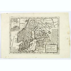
Sweden and Norway.
Herman Moll's mid eighteenth century map of Sweden and Norway, extending down to Denmark, across to Finland, and south to the Baltic states of Estonia, Livonia etc. With ...
- $125 / ≈ €109
Date: London, ca 1750

Carte particuliere des costes de Poittou, Aunis et de la Rochelle.
Finely designed and rare map of Isle Ré and the French coast with La Rochelle.
- $1250 / ≈ €1092
Date: Amsterdam, c. 1750
Charte der Kriegs Operationen am Donn u: Dnieper Ihro Russisch Kayserl Majestaet Glorieusen Armeen A: 1736
Scarce separately published map of the southern part of Ukraine, with an explanatory key A-N in the lower right. The map is surrounded by letterpress German text giving a...
Date: Augsburg, 1750
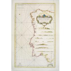
Carte Réduite Des Costes D'Espagne Et De Portugal Depuis le Cap Pinas jusqu'au Détroit de Gibraltar..
Large-scale sea chart covering all of the coast of Portugal, with eight coastal profile insets.The chart was engraved by Herman van Loon. With rhumb lines.Published by th...
- $500 / ≈ €437
Date: Paris, 1751
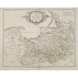
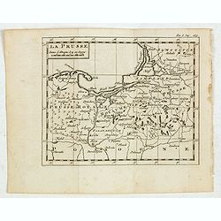
La Prusse divisée en Prusse Royale et Prusse Ducale. . .
Finely and crisply engraved map of Prussia including The Bay of Danzig. Folio map by Giles Didier Robert De Vaugondy.Ornamental title cartouche in the upper part of the m...
- $350 / ≈ €306
Date: Paris, 1751
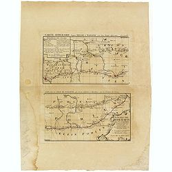
Polnische Reise Karte uber die vornehmsten Passagen von Dresden nach Warschau auf zweyerley Wegen I) uber Breslau, Peterkau und II) uber Lissa, Kaliez . . . 1751
Scarce strip-style road map showing two roads from Dresden via Glogau or Breslau to Warsaw.A key identifies villages, markets and post offices along the routes. Printed i...
Date: Nurember, 1751
Plan général de la ville capitale de Malte dressé sur les memoires des grands officiers de l'Ordre, dédiée et présentée à S.A.S. Mgr le prince de Conty, prince du sang, grand prieur de France. . .
First edition of this attractive large scale plan of Valetta on Malta. To the left and right a numbered key 1 - 269. In lower left, a title cartouche with a dedication to...
Date: Paris, 1751
Partie Méridionale de la Russie Européenne. . .
Detailed map of Ukraine, the Crimea and the northern part of the Caspian Sea.
Date: Paris, 1752
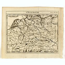
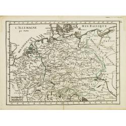
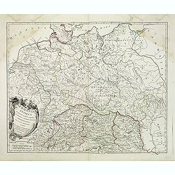
L'Allemagne.
Scarce small map of Germany, Poland and Low Countries based on cartography of Guillaume Delisle (. Published in "Nouveau traité de geographie par M**** ", publ...
- $50 / ≈ €44
Date: Paris, 1752
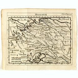
Moscovie.
Scarce small map centered on Muscovy and based on cartography of Guillaume Delisle (. Published in "Nouveau traité de geographie par M**** ", published by La v...
- $50 / ≈ €44
Date: Paris, 1752
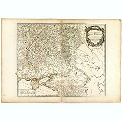
Partie méridionale de la Russie Européenne. . .
Detailed map of Ukraine and the Crimea. In lower right corner inset map of Cosaques. From his "Atlas Universel".Gilles Robert de Vaugondy (1688–1766), also kn...
Date: Paris, 1752
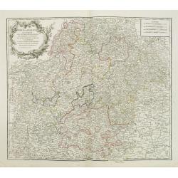
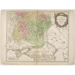
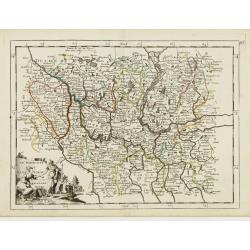
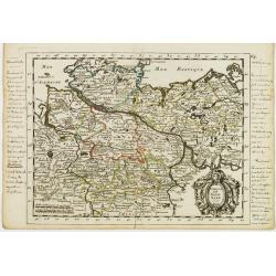
Cercle de Franconie . . .
Finely and crisply engraved map of part of Germany. Map by Giles Didier Robert De Vaugondy with erased title cartouche. Ornamental title cartouche in the upper part of ma...
- $50 / ≈ €44
Date: Paris, 1752
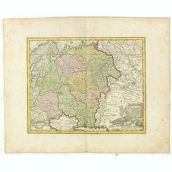
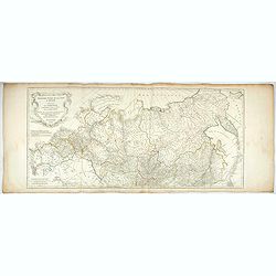
Partie Septentrionale de la Russie Européenne . . .
Detailed map of European part of Russia, including Finland, Lapland.
Date: Paris, 1753
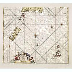
Paskaart Vande Noord Cust van Schotland als mede de Eylanden van Hitland en Fero. . .
Decorative chart, with south to the top. Latitude scale, compass rose and system of rhumb lines, soundings, anchorage's, etc. In the lower right corner, with added number...
- $500 / ≈ €437
Date: Amsterdam, 1753
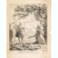
Britannia And Persia.
A finely engraved and unusual depiction of Britannia and Persia, two women with spears and shields holding a map between them. This map depicts a route through the Baltic...
- $800 / ≈ €699
Date: London, 1753
Partie Septentrionale de la Russie Européenne . . .
Detailed map of European part of Russia, including Finland, Lapland.
- $100 / ≈ €87
Date: Paris, 1753
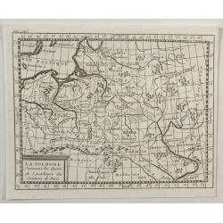
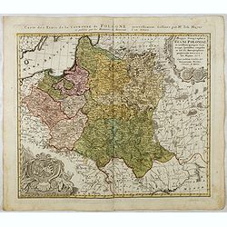
La Pologne.
An unusual 1752 Buffier copper engraved map of Poland. The map also covers Lithuania, part of Russia, Hungary, a portion of Ukraine, as well as a part of Romania. A decor...
Date: Paris, 1753
Troisième partie de la carte d'Asie, contenant la Sibérie, et quelques autres parties de la Tartarie. . .
Engraved map of Tartary on two sheets, with country boundaries in outline color. Includes geographic notes and ornamental cartouche by "H. Gravelot, invenit., DeLafo...
Date: Paris, 1753
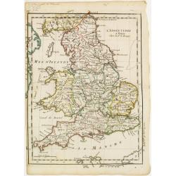
Le Royaume D'Angleterre, divise selon les sept Royaumes ou Heptrachie des Saxons, avec La Principaute De Galles, et subdivisie en Shires ou Comtes…
Decorative map of British Isles divided into the 7 ancient Heptarchies of the Saxons and also showing the more modern counties or shires. With Rococo title cartouche. Eng...
Date: Paris, 1753
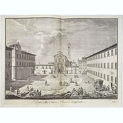
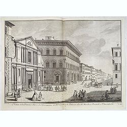
Veduta della Chiesa e Piazza d'Ognissanti.
Lively view of Piazza Ognissanti in Florence after Giuseppe Zocchi (1711or 1717 - 1767) and engraved by Giuseppe Papini. From "Scelta di XXIV Vedute delle principali...
Date: Florence, Bouchard, 1754
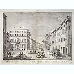
Veduta del Palazzo del Sig.re Marchese Strozzi, del Centauro e della Strada che conduce a S. Maria Novella.
Lively view of a square with the Palace of the Marquis Strozzi of Florence after Giuseppe Zocchi (1711or 1717 - 1767) and engraved by B.Sgrilli. From "Scelta di XXIV...
Date: Florence, Bouchard, 1754
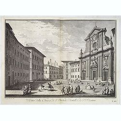
Veduta della Chiesa di S. Michele Bertelde de' PP. Teatini.
Lively view of a square with the Church of Santi Michele e Gaetano in Florence after Giuseppe Zocchi (1711or 1717 - 1767) and engraved by B.Sgrilli. From "Scelta di ...
Date: Florence, Bouchard, 1754
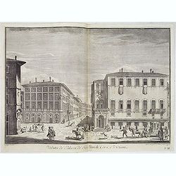
Veduta de' Palazzi de' Sig. March. Corsi e Viviani.
Lively street scene with several palaces in Florence after Giuseppe Zocchi (1711or 1717 - 1767) and engraved by Mich. Mariesschi and Vincenzo Francesschini. From "Sc...
Date: Florence, Bouchard, 1754
Veduta del Palazzo del Sig.re Principe Strozzi, e della strada che conduce al Ponte a S. Trinita.
Lively street scene with the palace of Mr. Strozzi in Florence after Giuseppe Zocchi (1711or 1717 - 1767) and engraved by Bal. Gabbuggiami from Rome. From "Scelta di...
Date: Florence, Bouchard, 1754
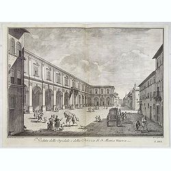
Veduta dello Spedale, e della Piazza di S. Maria Nuova.
Lively view of a square in Florence after Giuseppe Zocchi (1711or 1717 - 1767) and engraved by B.Sgrilli. From "Scelta di XXIV Vedute delle principali contrade, piaz...
Date: Florence, Bouchard, 1754
Veduta della Piazza, e Chiesa di S. Giovannino de' PP. Gesuiti, e de' Palazzi de' SS.ri Marchese Riccardi, e Panciatichi.
Lively street scene showing all the buildings aligned with Palazzo Medici Riccardi as far as the end of the road. The effect is that of a more imposing theatricality, wit...
Date: Florence, Bouchard, 1754
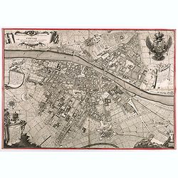
Pianta Della Citta di Firenze nelle seu vere misure colla descrizione dei luoghi piu notabili di ciascun Quartiere.
A highly decorative plan of Florence by Ferdinando Ruggieri. In addition to the detailed plan of the City, it includes fine decorative embellishments and demonstrates the...
Date: Florence, 1755
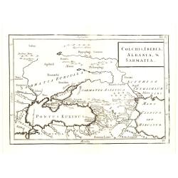
Colchis, Iberia, Albania..
Uncommon map covering the area in-between the Caspian Sea and the Black Sea. With title in upper right corner.
Date: London, 1755
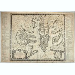
Plan de la Ville et du Port Mahon et du Fort St. Philippe..
Uncommon folding-map of the fort and town St.Philippe and port Mahon. In upper left corner a key in French (A-Z, Aa-Bb) and a key in Spanish (A-Z, Aa-Oo).A first state. A...
- $800 / ≈ €699
Date: Paris, 1756
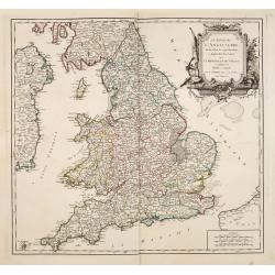
L'Angleterre.
Fine map of England and Wales. George Louis Le Rouge was active from 1740- till 1780 as a publisher, and was appointed engineer for the King of France. From his Atlas Nou...
Date: Paris 1756
L' Allemagne par Postes.
Fine map of Germany. George Louis Le Rouge was active from 1740 to 1780 as a publisher and was appointed engineer for the King of France. From his "Atlas Nouveau Por...
- $60 / ≈ €52
Date: Paris 1756
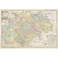
Le Marquisat et Electorat de Branderbourg.
Fine map of Brandenburg, with decorative title cartouche. George Louis Le Rouge was active from 1740- till 1780 as a publisher, and was appointed engineer for the King of...
- $30 / ≈ €26
Date: Paris 1756
Cercle de Basse Saxe.
Fine map of Lower Saxony, with decorative title cartouche. With manuscript notes in left and right margins giving some historical information about the region. George Lou...
- $50 / ≈ €44
Date: Paris, 1756
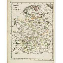
Cercle de Westphalie.
Fine map of North Rhine-Westphalia. George Louis Le Rouge was active from 1740 till 1780 as a publisher, and was appointed engineer for the King of France. From his Atlas...
- $30 / ≈ €26
Date: Paris 1756
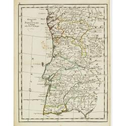
Royaume de Portugal.
Fine map of Portugal. With date 1743 added in manuscript.George Louis Le Rouge was active from 1740- till 1780 as a publisher, and was appointed engineer for the King of ...
Date: Paris, 1756
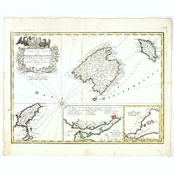
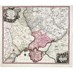
Carte des Isles de Maiorque Minorque et Yvice.
Uncommon map of Majorca, Minorca and Ibiza prepared by J.N. Bellin. With an inset plan of the harbor of Mahon "Plan du Port et de la Ville de Mahon", and a seco...
- $700 / ≈ €611
Date: Nuremberg, 1756
Germania Antiqua. . .
A fine map of ancient Germany, Poland and the Netherlands from his "Atlas Universel".Gilles Robert de Vaugondy (1688–1766), also known as Le Sieur or Monsieur...
Date: Paris, 1756
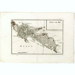
L'Isle de Ré.
Fine map of the French island called Île de Ré. George Louis Le Rouge was active from 1740- till 1780 as a publisher, and was appointed engineer for the King of Franc...
Date: Paris, 1756
Theatrum belli Russorum Victoriis illustratum sive Nova et accurata Turcicarum et Tartaricum. . .
Uncommon and decorative map of Ukraine, showing the theatre of the Russo-Turkish War in the Ukraine in 1735-1739. The map gives detailed information of the fortifications...
Date: Nuremberg, ca. 1757
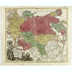
Spatiosissimum Imperium Russiae Magnae juxta recentissimas Observationes Mappa Geographica . . .
This is a decorative map of greater Russia, extending from Livonia in the west to Kamchatka, China, Tibet, Taiwan, Korea, and part of Japan in the east. To the south, it ...
- $1300 / ≈ €1136
Date: Augsburg, 1757
Mappa Geographica Regni Poloniae ex novissimis quotquot sunt mappis specialibus composita et al L.L. Stereographicae projectionis revocata a Tob. Mayero. . . .
Decorative map of Poland after Tobias Mayer who was based on Barnikel's map of Curland (1747) and Jan Nieprzecki's map of Lithuania (1749).Poland extends from Glogau and ...
Date: Nuremberg, 1757
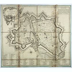
Plan de Hanover.
Town-plan of Hanover, with the new town of St Aegidien built in 1747. Decorated with a title cartouche and accompanied by a numbered key (1-79) of the main streets and bu...
- $200 / ≈ €175
Date: Paris, 1757
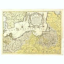
A New and Accurate Map of the Kingdom of Prussia, Pomerania, Courland & the Adjacent Parts Bordering on the Baltick Sea.
Attractive uncommon detailed map of the Kingdom of Prussia and the neighbouring regions, showing much of modern day Poland. Published in 'Universal Magazine', and well en...
- $750 / ≈ €655
Date: London, 1757
![[Lot of 8 maps of European Russia] Partie Septentrionale de la Russie Europeenne ou sont distinguees exactement toutes les Provinces](/uploads/cache/18563-(3)-250x250.jpg)
[Lot of 8 maps of European Russia] Partie Septentrionale de la Russie Europeenne ou sont distinguees exactement toutes les Provinces
[Lot of 8 maps of European Russia]- Partie Septentrionale de la Russie Européenne òu sont distinguées exactement toutes les Provinces (1753)- Carte des Pais Habites p...
- $600 / ≈ €524
Date: Atlas Universel PARIS 1757
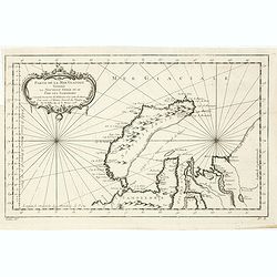
Partie de la Mer Glaciale contenant de la nouvelle Zemble..
A good engraved map of Nova Zembla. The geographical features are typical with somewhat exaggerated bays and inlets. From l'Histoire générale des voyages .
- $80 / ≈ €70
Date: Paris, 1758
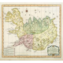
Carte de l'Islande pour servir á la continuation de l'histoire générale des voyages. Dressée sur celle de M. Horrebows.
A good engraved map of the island Iceland, prepared by Bellin after M. Horrebows, with rococo title cartouche in lower right. From l'Histoire générale des voyages.
- $300 / ≈ €262
Date: Paris, 1758
Neue Karte des Kuhrfürstenthums Sachsen. . .
Scarce road map, first published by Peter Schenk II (1698-1775) in his "Neuen Sächsischen Atlas". It is based on a map already created and 1732 and improved in...
- $750 / ≈ €655
Date: Amsterdam, 1758
Partie De La Mer Glaciale Contenant La Nouvelle Zemble et Le Pais Des Samoiedes . . . 1758
Detailed map of Nova Zembla and part of the Northeast passage.From Prevost's l'Histoire générale des voyages , the map prepared by J.N. Bellin. Jacques Nicolas Bellin (...
- $60 / ≈ €52
Date: Paris, 1758
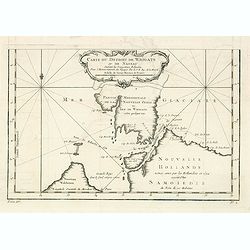
Carte du Detroit de Waigats ou de Nassau. . . 1758. N°.2.
Showing the Dutch voyage of 1594 which proved Nova Zemlya was an island separated from the continent by the "le Waigats Detroit". Several sounding shown.From Pr...
- $40 / ≈ €35
Date: Paris, 1758
Partie De La Mer Glaciale Contenant La Nouvelle Zemble et Le Pais Des Samoiedes . . . 1758
Detailed map of Nova Zembla and part of the Northeast passage.From Prevost's l'Histoire générale des voyages , the map prepared by J.N. Bellin. Jacques Nicolas Bellin (...
- $50 / ≈ €44
Date: Paris, 1758
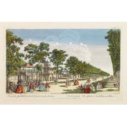
A View of the Grand Walk &c in Vauxhall gardens taken from the Entrance. Publish'd according to Act of Parliament..
So-called optical print illustrating Vauxhall gardens.In the eighteenth and nineteenth centuries, there were many popular specialty establishments in Paris, Augsburg and ...
Date: London, 1759
La Prusse.
Fine miniature map of Prussia, likely published by Claude Buffier. In upper right corner "Tom.I. Pag. 283.
- $150 / ≈ €131
Date: Paris, ca. 1759
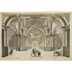
Vue des trois Gallerie, du Palais des Arts..Science a Rome.
So-called optical print. Daumont was a well-known publisher of optical prints, established in Paris. In the eighteenth and nineteenth centuries there were many popular sp...
Date: Paris, 1760

Vue interieur de l'Eglise de S.Pierre de Rome.
So-called optical print of St. Pieter church of Rome. A well-known publisher of optical prints, established in Paris. In the eighteenth and nineteenth centuries there wer...
Date: Paris, 1760
Vue perspective de la Grande Place de St.Francois a Seville.
So-called optical print. Daumont was a well-known publisher of optical prints, established in Paris. In the eighteenth and nineteenth centuries there were many popular sp...
Date: Paris, 1760
Partie Septentrionale des Pays Bas..
"Detailed map covering the Low Countries, published by Jean Latré."
Date: Paris 1760
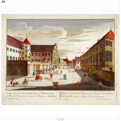
Der Zeug=Platz gegen S.Morizen Plaz zu Augspurg.
A well-known publisher of optical prints, established in Augsburg.In the eighteenth and nineteenth centuries there were many popular speciality establishments in Paris, A...
- $200 / ≈ €175
Date: Augsburg, 1760
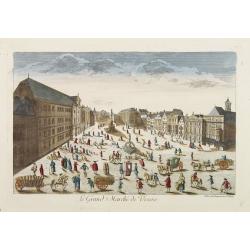
Le Grand Marché de Vienne.
Optical view of the Large Market Square in Vienna by Huquier, a well-known publisher of optical prints, established in Paris.In the eighteenth and nineteenth centuries, t...
- $200 / ≈ €175
Date: Paris 1760
Vue du Palais du Prince de Liechtenstein à Vienne.
Optical print of the palace of the Price of Liechtenstein in Vienna by Huquier, a well-known publisher of optical prints, established in Paris.In the eighteenth and ninet...
- $200 / ≈ €175
Date: Paris, 1760
Vue Perspective du Palais du Roy de Suede a Stokolm.
Perspective view of The Stockholm Palace by Huquier, a well-known publisher of optical prints, established in Paris.In the eighteenth and nineteenth centuries there were ...
Date: Paris 1760
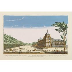
A view of the palace plaisans of Reyn Hongres...
So-called optical print of Aranjuez Palace near Madrid, and wrongly described as situated near to Vienna. Publishedby Huquier, a well-known publisher of optical prints, e...
- $125 / ≈ €109
Date: Paris, 1760
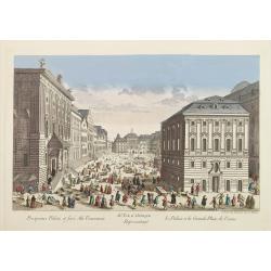
81e. Vue d'Optique Reprsentant Le Palais et la Grande Place de Vienne.
Optical print of a square in Vienna, by Daumont who was a well-known publisher of optical prints, established in Paris.In the eighteenth and nineteenth centuries there we...
Date: Paris, 1760
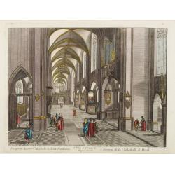
13e. Vüe d'Optique Representant L'Interieur de la Cathedralle de Dorth.
Optical view representing the interior of a Cathedral in Dörth, near Wiesbaden. Published by Daumont, a well-known publisher of optical prints, established in Paris.In t...
- $200 / ≈ €175
Date: Paris, 1760
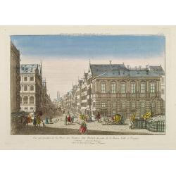
Vue perspective de la Place des Peintres ditte Perlach du cote de la Basse Ville a Prague.
A so-called optical print of a square in Prague by Basset, a well-known publisher of optical prints, was established in rue S.Jacques in Paris. With brief key list.In the...
- $300 / ≈ €262
Date: Paris, 1760
