Browse Listings in Europe
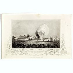
Bombardment of Odessa by the English and French April 22 1854, explosion on the imperial mole . . .
Scene from the Crimea war, showing a bombardment of Odessa, 22nd April 1854 (during Crimean War, 1853-56), by English and French forces, explosion imperial mole (breakwat...
- $30 / ≈ €26
Date: London, ca. 1879
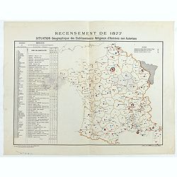
Recensement de 1877. Situation Géographique des Etablissements Religieux d'Hommes non Autorisés.
Rare map showing private secondary schools for boys created by unauthorized religious congregations. On sale at M. Devillaire, 43, R. du Four St. Germain in Paris / at M....
Date: Paris, F. Appel, 1879

Sint Catharinakerk te Eindhoven
Uncommon print of St.Catharina church of Eindhoven, built by the well-known architect P.Cuijpers. Published in Katholieke Illustratie .
- $85 / ≈ €74
Date: 'sHertogenbosch, 1880
![Sint-Catharinakerk te Eindhoven [with plan]](/uploads/cache/28813-250x250.jpg)
Sint-Catharinakerk te Eindhoven [with plan]
Uncommon wood engraved print of St.Catharina church in Eindhoven, built by the well-known architect P.Cuijpers. Published in Kunstkronijk. This wood engraving is similar ...
- $85 / ≈ €74
Date: Amsterdam, c.1880

The attempt on the Czar's life: the Soltykoff dorway of the Winter Palace . . .
A panorama of the Winter Palace published in the Illustrated London News of 1880.
- $20 / ≈ €17
Date: London, 28 February, 1880

The attempt on the Czar's life: The Winter Palace, St Petersburg.
A panorama of the Winter Palace with an attempt on the Czar's life published in the Illustrated London News of 28 February, 1880.
- $15 / ≈ €13
Date: London, 28 February, 1880

The attempt on the Czar's life: The Grand Ball-Room . . .
A panorama of the Winter Palace with an attempt on the Czar's life published in the Illustrated London News of 28 February, 1880.
- $15 / ≈ €13
Date: London, 28 February, 1880
Porte Ste Barbe.
View of the gate of St. Barbe. Title in Russian and French.
- $50 / ≈ €44
Date: Russia, ca. 1880
Bataille de la Moskova.
Etching of a battle in which Napoleon's army fought the Russian army of general Kutuzov on 7 September 1812.Etched by Auguste II. Boulard (1852–1927) after a painting b...
- $50 / ≈ €44
Date: Paris, 1880
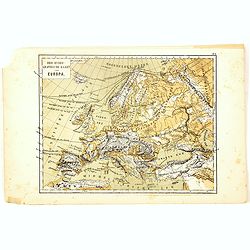
Oro-Hydrographische Kaart van Europa.
One of the earliest thematic maps of Europe published in the Netherlands from "Atlas der natuurkundige aardrijkskunde. . .". prepared by Nicolaas Wilhelmus Post...
- $35 / ≈ €31
Date: Amsterdam, C.L. Brinkman, 1883
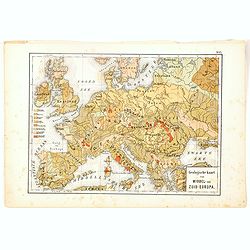
Geologische Kaart van Middel- en Zuid-Europa.
One of the earliest thematic maps published in the Netherlands from "Atlas der natuurkundige aardrijkskunde. . .". prepared by Nicolaas Wilhelmus Posthumus. Wit...
- $35 / ≈ €31
Date: Amsterdam, C.L. Brinkman, 1883
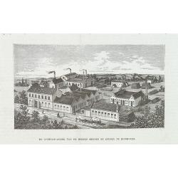
De luciferfabriek van de Heeren Mennen en Krunen te Eindhoven.
Wood engraving published in "Katholieke Illustratie", showing the match factories of Mennnen en Krunen in Eindhoven. Founded in 1870 by banker Christiaan Mennen...
- $40 / ≈ €35
Date: s-Hertogenbosch, H.Bogaerts, ca. 1885
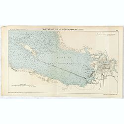
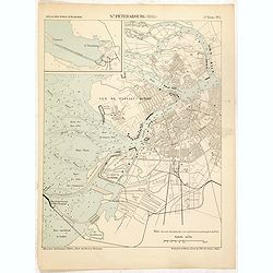
Cronstadt et St. Petersbourg.
Detailed plan of the port and city of St. Petersburg including Kotlin Island and the fortified town of Kronstadt.
- $35 / ≈ €31
Date: Paris, 1888
St. Pétersbourg (1888).
Map of St. Petersburg from a French multi volume atlas published by the Ministere des Travaux Publics (Ministry of Civil Engineering), called "Atlas des ports étran...
- $120 / ≈ €105
Date: ?Paris, Imprimerie Nationale 1884-1889
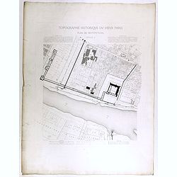
Topographie historique du vieux Paris / Plan de restitution Feuille V.
Copper engraved plan centered on Louvre by Jean-Joseph Sulpis (1826–1911) after a model by Adolphe Berty. Plate 5 from "Topographie historique du vieux Paris"...
Date: Paris, 1866-1897
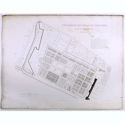
Topographie historique du vieux Paris / Plan de restitution Feuille V bis.
Copper engraved plan centered on gardens of the Louvre by Jean-Joseph Sulpis (1826–1911) after a model by Adolphe Berty. Plate 5bis from "Topographie historique du...
Date: Paris, 1866-1897
![[Map of the Alps].](/uploads/cache/46164-250x250.jpg)
[Map of the Alps].
Alexey Afinogenovich Ilyin was a lieutenant general and cartographer (1832-1889). In 1856, after graduating from the Academy of the General Staff, he was at the military ...
- $45 / ≈ €39
Date: St. Petersburg, 1899
![[Lake Garda and its surroundings].](/uploads/cache/46166-250x250.jpg)
[Lake Garda and its surroundings].
Alexey Afinogenovich Ilyin was a lieutenant general and cartographer (1832-1889). In 1856, after graduating from the Academy of the General Staff, he was at the military ...
- $100 / ≈ €87
Date: St. Petersburg, 1899
![[France - The Netherlands - Belgium].](/uploads/cache/46168-250x250.jpg)
[France - The Netherlands - Belgium].
Alexey Afinogenovich Ilyin was a lieutenant general and cartographer (1832-1889). In 1856, after graduating from the Academy of the General Staff, he was at the military ...
- $50 / ≈ €44
Date: St. Petersburg, 1899
![[The United Kingdom - Sweden, Norway, Denmark].](/uploads/cache/46169-250x250.jpg)
[The United Kingdom - Sweden, Norway, Denmark].
Alexey Afinogenovich Ilyin was a lieutenant general and cartographer (1832-1889). In 1856, after graduating from the Academy of the General Staff, he was at the military ...
- $50 / ≈ €44
Date: St. Petersburg, 1899
![[Oxford Canal from Oxford to Coventry].](/uploads/cache/37232-250x250.jpg)
[Oxford Canal from Oxford to Coventry].
Manuscript map covering the Oxford Canal. Orientated East to the North. The Oxford Canal is a 78-mile-long (126 km) narrow canal in central England linking Oxford with Co...
- $140 / ≈ €122
Date: ca. 1900

Léon Tolstoy.
Etching by Gustaf Frank after a painting of Ilya Repin (1887). Gustav Frank (1859-1923) attended school in Vlasim, where he learned to draw from Cenka Schneider. Then he ...
- $50 / ≈ €44
Date: Vienna, 1900
![[map printed on a tissue] The British remedy for coughs and colds. Owbridge's lung tonic.](/uploads/cache/40288-250x250.jpg)
[map printed on a tissue] The British remedy for coughs and colds. Owbridge's lung tonic.
Handkerchief showing a map of Europe and part of Asia continent printed on a tissue. OWBRIDGE’S LUNG TONIC, THE BRITISH REMEDY FOR COUGHS AND COLDS.Walter Thomas Owbrid...
- $400 / ≈ €349
Date: London, ca. 1900
![[Les anciennes provinces Françaises à la ville de Saint Denis].](/uploads/cache/41681-250x250.jpg)
[Les anciennes provinces Françaises à la ville de Saint Denis].
Nine small chromolithography's trade cards for Ville de Saint Denis, each with French regions and places, with description in French on each verso.Cards of the regions : ...
Date: Paris, circa 1900
![[Les anciennes provinces Françaises à la ville de Saint Denis].](/uploads/cache/41683-250x250.jpg)
[Les anciennes provinces Françaises à la ville de Saint Denis].
Nine small chromolithography trade cards for Ville de Saint-Denis, each with French regions and places, with description in French on each verso.Cards of the regions: Lor...
Date: Paris, circa 1900
![[Les anciennes provinces Françaises à la ville de Saint Denis].](/uploads/cache/41684-250x250.jpg)
[Les anciennes provinces Françaises à la ville de Saint Denis].
Nine small chromolithography's trade cards for Ville de Saint Denis, each with French regions and places, with description in French on each verso.Cards of the regions : ...
Date: Paris, circa 1900
![[Map of Grodno gubernia.]](/uploads/cache/81813-250x250.jpg)
[Map of Grodno gubernia.]
Карта Гродненско&...
- $450 / ≈ €393
Date: Sankt Peterburg, 1850-1900
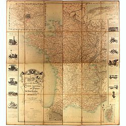
Carte routière de France de Dion Bouton spéciale pour automobiles
Highly decorative folding wall map of France in a scale of 1 : 800 000. In the upper left hand corner an inset plan of Paris, upper right Algeria and lower right map of C...
- $1500 / ≈ €1310
Date: Paris, J. Barreau, 1900
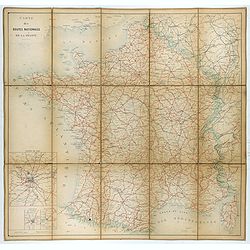
Carte nationale des routes de la France.
Map of the national roads in France, engraved and published by Regnier et Dourdet. Four inset maps of which three shows the three largest cities in France and one shows C...
- $75 / ≈ €66
Date: Paris, ca. 1900
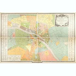
Plan des paroisses de Paris avec la distinction des parties éparses qui en dépendent dressé... par J. Junié, Ingén. Géogr. De Monseigneur l'Archeveque et géomètre des Eaux et forêts de ...
Large wall map size plan of Paris in 4 separate sheets, if joined forming a plan of Paris of 93 x 60cm. This plan is a 1904 version of a manuscript plan drawn in 1786 by ...
Date: Paris, Service des Travaux historiques de la Ville de Paris, 1904

Excelsiori (Rana N. 28 - Cent. 20).
"After so many wars and so many troubles, young Russia, in a more serene glaze all the beautiful sun of freedom you will enjoy ... ". Fascinating allegorical sa...
Date: Bologna, 1905
![Karta Evropeiskoi Rossii i Sibirii na 4 listakh [ Map of European Russia and Siberia in 4 sheets compiled and based on the most advanced statistical and geographical information.]](/uploads/cache/43927-250x250.jpg)
Karta Evropeiskoi Rossii i Sibirii na 4 listakh [ Map of European Russia and Siberia in 4 sheets compiled and based on the most advanced statistical and geographical information.]
A fine large map showing Eastern Europe from Stockholm to Constantinople, with Russia eastward from Perm and south to the Caucasus and Iran. With indications of judicial ...
- $750 / ≈ €655
Date: Saint Petersburg, 1908
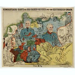
Humoristische Karte von Europa im Jahre 1914.
A satirical map of Europe with a title in German that marks the outbreak of the First World War, probably conceived between August and October 1914. Lehmann-Dumont was no...
Date: Dresde, Leutert & Schneidewind, ca. 1914
![[Goose game board] Le 1914 Edition pochette.](/uploads/cache/47215-250x250.jpg)
[Goose game board] Le 1914 Edition pochette.
Goose game in the form of a folding map of north of France and Belgium, with part of England, Germany, Holland and Luxembourg.
- $450 / ≈ €393
Date: Paris, 1914

Karte von Europa im Jahre 1870 nach einem französischen Holzschnitte.
Satirical illustration by Paul Hadol showing disposition of power in Europe at the beginning of 1870. Satirical print depicting a map of Europe in which the countries are...
Date: Hamburg, Fuchs, 1914

A very early large London Underground enamel station sign for Westerminster Station
This large enamel sign can be dated between 1908 and 1915, when the bull’s-eye design, a solid red disk with a horizontal bar containing the text, was adopted by all th...
- $22000 / ≈ €19218
Date: London, ca. 1908-1915
![[Map of Turkey in Ottoman script]](/uploads/cache/40765-250x250.jpg)
[Map of Turkey in Ottoman script]
Map of Turkey, including Cyprus, with text in Ottoman script. In the bottom a color key to the different regions. Published by Elbemühl Graphische Industrie in Vienna (f...
Date: Vienna, ca. 1915
![[2 maps] Das Europa der Zukunft... / Das heutige Europa…[The Europe of the Future / The Europe of Today]](/uploads/cache/48735-250x250.jpg)
[2 maps] Das Europa der Zukunft... / Das heutige Europa…[The Europe of the Future / The Europe of Today]
A pair of very scarce WWI German maps highlighting Europe as it currently was, and Europe as it may become. The maps were produced as part of an 8 page booklet produced b...
- $2750 / ≈ €2402
Date: Paris, 1917
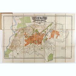
Cesu un apkartnes vadonis ar Cesu pilsetas planu. . .
Uncommon and detailed plan of Cesis and its direct surroundings. Cesis is a town in northeastern Latvia, built in the 13th century and one of the best-preserved medieval ...
- $550 / ≈ €480
Date: Cesu, 1928

Femme de Barèges (106, La Gascogne).
Plate published in "Les costumes régionaux de France" with illustrations by Gratiane de Gardilanne (painter and designer) and Elisabeth Whitney Moffat.Costume ...
Date: Paris, Editions du Pégase, 1929

Laitière Bordelaise, d'après de Gallard (110, La Guyenne).
Plate published in "Les costumes régionaux de France" with illustrations by Gratiane de Gardilanne (painter and designer) and Elisabeth Whitney Moffat.Costume ...
- $75 / ≈ €66
Date: Paris, Editions du Pégase, 1929
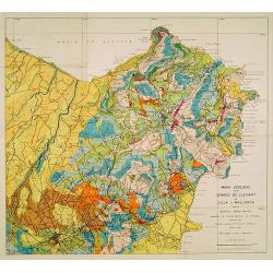
Mapa geologic de les serres de Llevant de l'illa de Mallorca.
Geological map showing part of the island Mallorca Manacor, Son Severa, Capdepera.. After a design by D.Ferrá. Dibuxá, in lower right corner: D.Ferrà. Dibuxá.Provenan...
- $150 / ≈ €131
Date: Palma, 1932
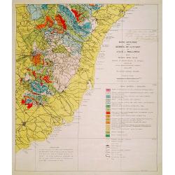
Mapa geologic de les serres de Llevant de l'illa de Mallorca.
Geological map showing part of the island Mallorca Felanitx, Santanyi, Porto Cristo, Porto Colom.., including a legend with geological and topographical signs. After a de...
- $100 / ≈ €87
Date: Palma, 1932
![Environs de Raguse (Dubrovnik). Deuxième Feuille. Canal de Calamota (Kolocep).. [277]](/uploads/cache/23473-250x250.jpg)
Environs de Raguse (Dubrovnik). Deuxième Feuille. Canal de Calamota (Kolocep).. [277]
This large-scale coastal chart shows the stretch of the Dalmatian coast between Slano as far as the island of Kolocep, the southernmost inhabited island in Croatia. With ...
- $200 / ≈ €175
Date: Paris [1877] corrected to 1932
![Mer Adriatique. Côte Orientale. De l'Ile Meleda à Antivari.. [3552]](/uploads/cache/23471-250x250.jpg)
Mer Adriatique. Côte Orientale. De l'Ile Meleda à Antivari.. [3552]
This large scale coastal chart shows the stretch of Dalmatian coast between the island Mljet in Croatia as far as Ulcinj (Montenegro). With latitude and longitude scales,...
- $200 / ≈ €175
Date: Paris [1877] corrected to 1934
![Mer Adriatique. Partie Sud.. [3976]](/uploads/cache/23549-250x250.jpg)
Mer Adriatique. Partie Sud.. [3976]
This large scale coastal chart centered on the southern part of the Adriatic sea. Showing the Dalmatian coast between Split in Croatia as far as the northernmost tip of C...
- $200 / ≈ €175
Date: Paris [1883] updated for 1935
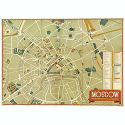
Moscow.
A nice colored lithographic town plan of the Russian capital, in English, published in 1938 in order to promote the U.S.S.R's cultural image overseas during Stalin's term...
- $750 / ≈ €655
Date: Moscow, ca 1938
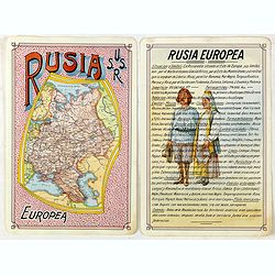
Rusia Europae U.S.S.R.
Detailed map of Russia. Unique manuscript map of Russia. Award-winning manuscript card, prepared by Antonio Raggio for the 11th Congreso de la Union Postal Universal (Wor...
- $450 / ≈ €393
Date: Buenos Aires, 1939
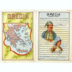
Grecia.
Unique manuscript map of Greece. Award-winning manuscript card, prepared by Antonio Raggio for the 11th Congreso de la Union Postal Universal (World Postal Congress) Expo...
- $250 / ≈ €218
Date: Buenos Aires, 1939
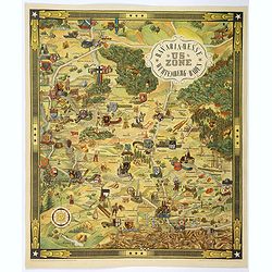
US ZONE. Bavaria, Hesse, Wurtemberg, Baden.
An unusual decorative pictorial map, from the years immediately following World War II, depicting the American Zone of Occupation in southern Germany. It portrays rural ...
- $450 / ≈ €393
Date: Munich, 1940
![Map of the Occupied Areas. Carte des Zones d'Occupation. Der Besatzungs-Zonen mit Neuen Postleitgebieten. Karta Okkupacionnych Zon [in Cyrillic.]](/uploads/cache/42060-250x250.jpg)
Map of the Occupied Areas. Carte des Zones d'Occupation. Der Besatzungs-Zonen mit Neuen Postleitgebieten. Karta Okkupacionnych Zon [in Cyrillic.]
A poster map of Germany and Austria showing the Allied occupation zones as agreed at the Potsdam Conference after the end of the Second World War, with an inset detail of...
Date: Frankfurt-am-Maine: Atlanta-Service, 1946
MEMORANDUM Vlade Demokratske Federativne Jugoslavije po pitanju Juliske Krajine i drugih jugoslavenskih teritorija pod Italijom.
Memorandum of the government of the Democratic Federative Yugoslavia concerning the questions of the Jilian March and other Yugoslav territories under Italy.Julian March ...
- $300 / ≈ €262
Date: London, 1946
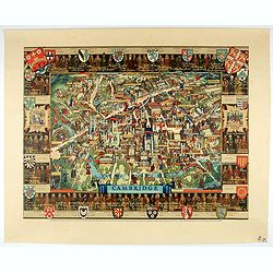
Cambridge.
Though the city had endured significant damage during the Second World War, which ended only a few years prior to publication, there is little indication of the destructi...
- $550 / ≈ €480
Date: London, 1948
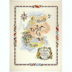
L'Europe Centrale et Orientale.
Pictorial tourism poster of central and eastern Europe, showing different life scenes relative to the culture's country.Learn more about pictorial maps. [+]
- $100 / ≈ €87
Date: Paris, 1951
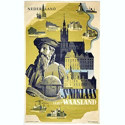
Sint Niklaas en het Waasland Gerardus Mercator Museum.
Poster showing a portrait of Gerard Mercator, set behind a globe and the town hall of St. Niklaas. Showing a map of the region containing pictorial vignets of Overmere, K...
- $500 / ≈ €437
Date: Brussels, 1951
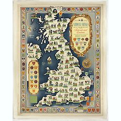
National saving map og the British Isles . . .
A brilliantly eccentric poster showing the festivals, customs of the British Isles with the arms and seals of the counties.Founded in 1861, National Savings is a state-ow...
- $450 / ≈ €393
Date: London, 1951
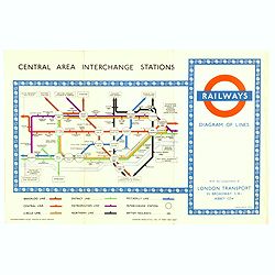
1953 Harry Beck London Underground map.
Published in the Queen's coronation year. A London Underground map (double sided).
- $150 / ≈ €131
Date: London, 1953
![[Pictorial map of Georgia (Caucasus)].](/uploads/cache/44292-250x250.jpg)
[Pictorial map of Georgia (Caucasus)].
A scarce pictorial map of a region in Georgia in the Caucasus. Map is entirely in Russian, complete with legend at base of map, with small thumbnail pictures and symbols ...
- $150 / ≈ €131
Date: Moscow, 1963
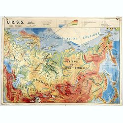
U.S.S.R. Carte Physique. / U.S.S.R. Carte Population.
An unusual school map with on one side a physical map of Russia on verso a map of Russia according to population. Prepared by Pierre Serryn (1916-2002) who was professor ...
- $200 / ≈ €175
Date: St-Germain-en-Laye, 1965
U.S.S.R. Carte Agricole. / U.S.S.R. Carte Industries et communications.
An unusual school map with on one side an agricultural map of Russia on verso a map of Russia showing communication an according to population. Prepared by Pierre Serryn ...
- $200 / ≈ €175
Date: St-Germain-en-Laye, 1965
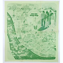
Beatles Map.
A lovely example of the scarce 'Beatles Map' of Liverpool, published in 1974 to commemorate the buildings and places where the Beatles started their stellar careers. The ...
Date: Liverpool, 1974
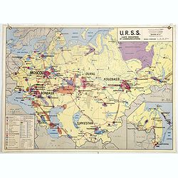
U.R.S.S. Industrie. Partie européenne, Asie centrale. (3)
Map of Eastern Russia. Propaganda poster for Russia's industry. Text in French. Editions de l'Agence de presse Novosti".More about War Maps & Propaganda maps [+]
- $100 / ≈ €87
Date: USSR, 1978
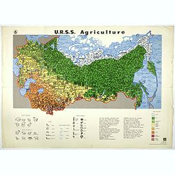
U.R.S.S. Agriculture. (6)
Map of Russia. Propaganda poster for Russia's in and export of industrial goods. With a key in bottom. Text in French. Editions de l'Agence de presse Novosti".More a...
- $100 / ≈ €87
Date: USSR, 1978
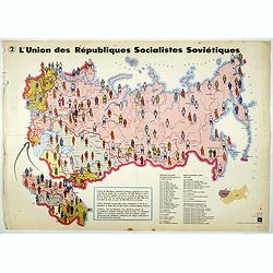
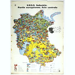
L'Union des Républiques socialistes Soviétiques. (2)
Map of Russia. Propaganda poster showing Russia' s population. With a key. Text in French. Editions de l'Agence de presse Novosti".More about War Maps & Propagan...
- $100 / ≈ €87
Date: USSR, 1978
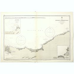
Black sea - Sheet IX - Bosporus to Kerempe Burnu . . .
A highly corrected version of Admiralty chart 2238 originally published 16th June 1854. Edition Date 1980.Detailed chart of Bosporus. With prohibited landing places in pu...
- $100 / ≈ €87
Date: London, 1854-1980
