Browse Listings in Europe
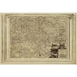
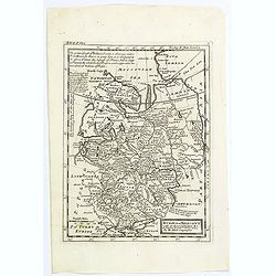
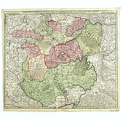
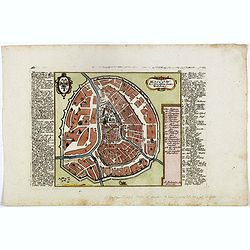
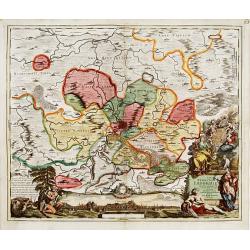
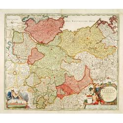
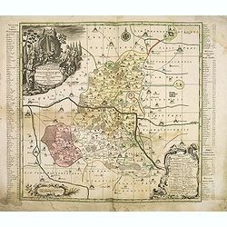
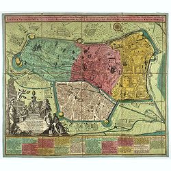
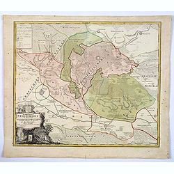
Landgraviat de Hesse, suivant les nouvelles observations..
With decorative title cartouche lower right corner.This example is unusual in having the additional separately engraved decorative framework border around the map, the re...
- $90 / ≈ €79
Date: Amsterdam 1728
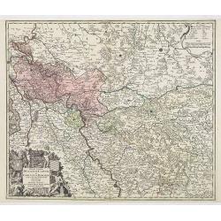
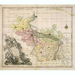
Nova et Accurata Ducatus Cliviae et Comitatus Marchiae.
With an elaborate -uncolored- title cartouche.
Date: Augsburg, 1728
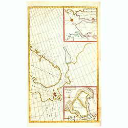
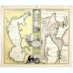
A Chart of the Sound -- A Map of the rivers Elbe and Weser -- The River Dvina and the harbour of Archangel.
Scarce sea chart by John Harris (1667?-1719) and James Knapton (d. 1738). Chart 20 from "Atlas maritimus & commercialis", shows Lapland and part of the Russ...
- $400 / ≈ €349
Date: London, J. Knapton, 1728
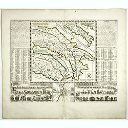
L'Italie dans son Premier Etablissement sous la Republique Romaine. . .
Map of Italy when first established under the Roman Republic after the division by Ayuguste Caesar, its various Papal governments: ancient Rome and its surround dings, a ...
Date: Amsterdam, 1728
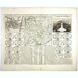
Carte Historique et Geographique pour Introduire a l' Intelligence de l'Histoire de Savoye . . .
Folio sheet with an attractive map of the border region of France, Switzerland and Italy. An inset map of the fortification of Torino and the Palace of Venerie. Cartouche...
Date: Amsterdam, 1728
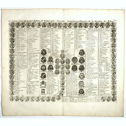
Carte genealogique des Rois de France avec l'Etat des Principaux Officiers de la Maison du Roy.
A genealogical tree of the French Kings with descriptive French text, from Chatelain's monumental 7 volume "Atlas Historique". Henri Abraham Chatelain (1684 –...
- $35 / ≈ €31
Date: Amsterdam, 1728
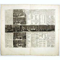
Carte du Gouvernement Civil de France.
This impressive engraving is a wonderful example of Chatelain’s elegant plates. It provides a detailed description of the infrastructure of the French government. Ornam...
- $75 / ≈ €66
Date: Amsterdam, 1728
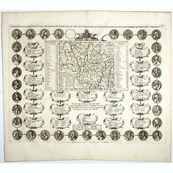
Carte Pour L'Intelligence De L'Histoire De Lorraine . . .
Map of Lorraine, surrounded by 34 portraits of the rulers of Lorraine and information concerning the present government structure of the Duchy. Surmounted by an elaborate...
Date: Amsterdam, 1728
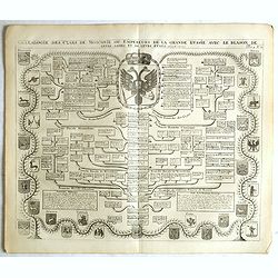
Généalogie des Cazrs de Moscovie ou empereurs de la grande Russie . . .
Genealogical tree, showing the lineage of the Russian Czar's, dating back to 840 according to Hubner. Published by Henri Abraham Chatelain (1684 – 1743) a Huguenot past...
- $250 / ≈ €218
Date: Amsterdam, 1728
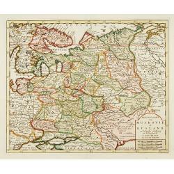
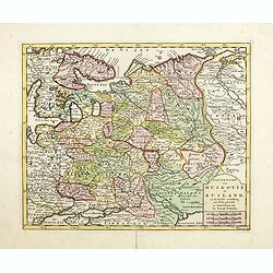
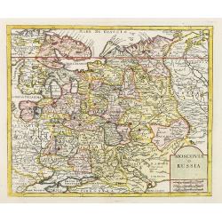
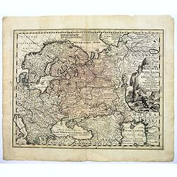
Russia or Moscovy with its Acquisitions &c.
Herman Moll's map of western Russia, or Muscovy, published in London during the first half of the eighteenth century. It shows the newly acquires lands taken from Sweden ...
Date: London, 1729
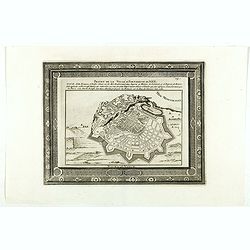
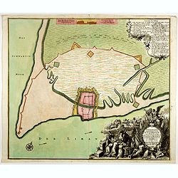
Projet de la forteresse de Nice.
Nice city plan of Nice at the Mediterranean sea. From the " Les forces de l'Europe, ou description des principales villes, avec leurs fortifications".
Date: Leiden, 1729
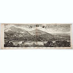
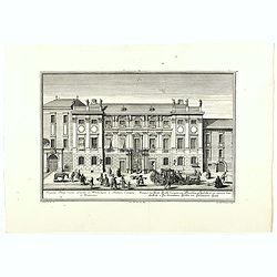
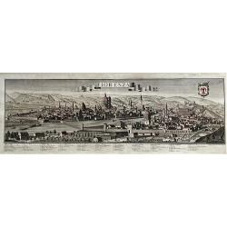
Heidelberg.
A spectacular panoramic view of Heidelberg, with legends numbered from 1-72 in German. With the title in a banderol.After a design by Friedrich Bernhard Werner (1690-1776...
- $1500 / ≈ €1310
Date: Augsburg, 1729
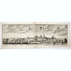
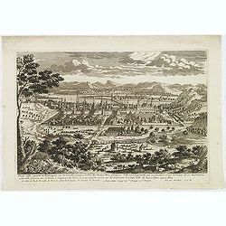
Neis in Schlesien. (Nysa)
A spectacular panoramic view of Nysa in southwestern Poland, with legends numbered from 1-23 in German. With the title in a banderol.After a design by Friedrich Bernhard ...
- $2500 / ≈ €2184
Date: Augsburg, 1729
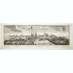
Lirgnitz. (Legnica)
A spectacular panoramic view of Legnica in southwestern Poland, in the central part of Lower Silesia, with legends numbered from 1-20 in German. With the title in a bande...
- $2500 / ≈ €2184
Date: Augsburg, 1729
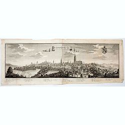
Schweidnitz. (Swidnica)
A spectacular panoramic view of Swidnica is a city in south-western Poland, with legends numbered from 1-19 in German. With the title in a banderol.After a design by Frie...
- $2500 / ≈ €2184
Date: Augsburg, 1729
Bamberg in Francken.
A spectacular panoramic view of Bamberg, with legends numbered from 1-24 in German. With the title in a banderol.After a design by Friedrich Bernhard Werner (1690-1776) w...
- $1500 / ≈ €1310
Date: Augsburg, 1729
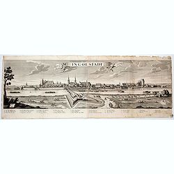
Ingolstadt.
A spectacular panoramic view of Ingolstadt in Bavaria, with legends numbered from A-P and 1-6 in German. With the title in a banderol.After a design by Friedrich Bernhard...
- $1500 / ≈ €1310
Date: Augsburg, 1729
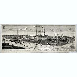
Hamburg.
A spectacular panoramic view of Hamburg, with legends numbered 1-19 and A-Z in German. With the title in a banderol.After a design by Friedrich Bernhard Werner (1690-1776...
- $2000 / ≈ €1747
Date: Augsburg, 1729
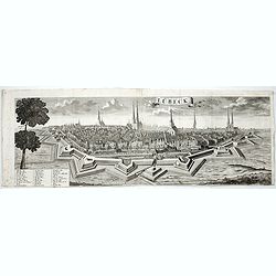
Lübeck.
A spectacular panoramic view of Lübeck, with legends numbered 1-28 in German. With the title in a banderol.After a design by Friedrich Bernhard Werner (1690-1776) who wa...
- $1500 / ≈ €1310
Date: Augsburg, 1729
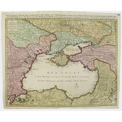
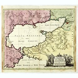
Nouvelle Carte de la Petite Tartarie et la Mer Noire, montrant les Frontieres de l'Impératrice de Russie et de l'Empereur des Turcs, tant en Europe qu'en Asie, Dessigné selon la proposition de G. De L'Isle et d'autres Auteurs.
The Ukraine and the Black Sea in a fine impression with original 18th-c. hand-coloring.
- $1250 / ≈ €1092
Date: Amsterdam, 1730
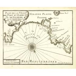
Plan de la Ville, Port et rades de Palerme. . .
An attractive chart centered on Palermo. With scale and large compass-rose. Dated 1727, with the privilege of the King. From : Recueil des Plusieurs plans des ports et ra...
- $250 / ≈ €218
Date: Marseille, 1730
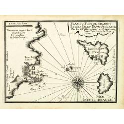
Plan du Port de Trapano et des isles Favouillane.
An attractive chart centered on Trapani on the west coast of Sicily in Italy. It is the capital of the Province of Trapani. The right the island of Favignana and Levanzo ...
- $300 / ≈ €262
Date: Marseille, 1730
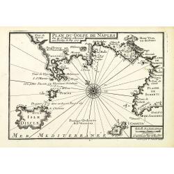
Plan du Golfe de Naples.
An attractive chart centered on the Gulf of Naples. Mount Vesuvius to the right. With scale and large compass-rose. Dated 1727, with the privilege of the King. From : Rec...
- $350 / ≈ €306
Date: Marseille, 1730
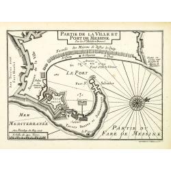
Plan de la Ville et Port de Messine.
An attractive chart centered Messina on Sicily. With scale and large compass-rose. Dated 1727, with the privilege of the King. From : Recueil des Plusieurs plans des port...
- $250 / ≈ €218
Date: Marseille, 1730
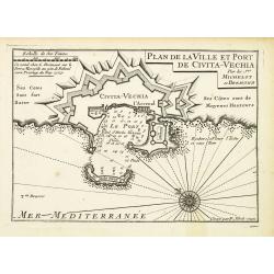
Plan de la Ville et Port de Civita-Vechia.
An attractive chart centered on Civitavecchia, a town and comune of the province of Rome in the central Italian region of Lazio.With scale and large compass-rose. Dated 1...
- $200 / ≈ €175
Date: Marseille, 1730
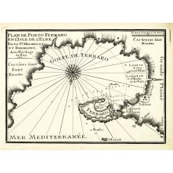
Plan de Porto Ferraro en l'isle de l'Elbe.
An attractive chart centered on the Mediterranean. With scale and large compass-rose. Dated 1727, with the privilege of the King. From : Recueil des Plusieurs plans des p...
- $200 / ≈ €175
Date: Marseille, 1730
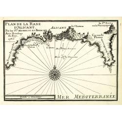
Plan de la Rade d'Alicant.
An attractive chart centered Alicante in Valencia along the Mediterranean. With scale and large compass-rose. Dated 1730, with the privilege of the King. From : Recueil d...
- $350 / ≈ €306
Date: Marseille, 1730
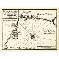
Plan de la Rade de Mayorque.
An attractive chart centered on Palma de Majorca in the Mediterranean. With scale and large compass-rose. Dated 1727, with the privilege of the King. From : Recueil des P...
- $600 / ≈ €524
Date: Marseille, 1730
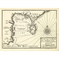
Plan de la Baye de Gibraltar.
An attractive chart centered on Gibraltar. With scale and large compass-rose. Dated 1727, with the privilege of the King. From : Recueil des Plusieurs plans des ports et ...
- $375 / ≈ €328
Date: Marseille, 1730
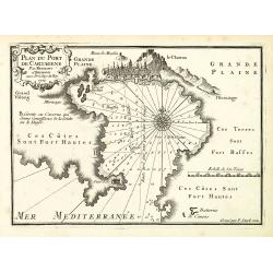
Plan du Port de Cartagène.
An attractive chart centered on the Bay of Cartagena. With scale and large compass-rose. Dated 1727, with the privilege of the King. From : Recueil des Plusieurs plans de...
- $375 / ≈ €328
Date: Marseille, 1730
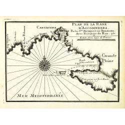
Plan de la Rade d'Ascombrera. . .
An attractive chart centered on Cartagena in Spain. With scale and large compass-rose. Dated 1730, with the privilege of the King. From : Recueil des Plusieurs plans des ...
- $300 / ≈ €262
Date: Marseille, 1730
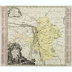
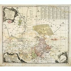
Praefectura Lipsiencis. . .
Detailed map centered around Leipzig with large pictorial cartouche and smaller cartouche of explanations. Alphabetical list of place names down both sides.
- $150 / ≈ €131
Date: Augsburg, 1730
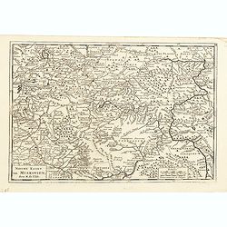
Imperii Moscovitici pars Australis.
A detailed map of the region around Moscow. Including the Ukraine and Cossack regions, to the west is Russian Poland and Lithuania, to the east Russian Tartary and Siberi...
- $500 / ≈ €437
Date: Augsburg, 1730
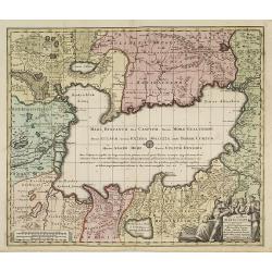
Geographica Nova ex Oriente gratiosissima, duabus tabulis specialissimis contenta, quarum una Mare Caspium..
Map of the Caspian Sea and the peninsula of Kamchatka (Jedso) in northeast Asia on one sheet.Separated by an attractive panel with figurative title cartouche, cherubs, an...
Date: Nuremberg, 1730
Nova Mappa Geographica Maris Assoviensis Vel De Zabache Et Paludis Maeotidis accurate aeri incis et in luce edita . . .
Striking map of the Sea of Azov with adjacent countries and the Strait of Kerch, with a decorative allegorical cartouche, showing the costumes of the indigenous people of...
Date: Augsburg, 1730
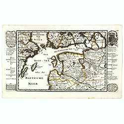
Der Nordischen Königreiche Süd=Oost Theil begreiffende Liefland Ingermanland und Finnland zum Theil.
Uncommon map published by Gabriel Bodenehr, who bought the Stridbeck copper plates in 1716, and continued publishing the Stridbeck Atlas: "Atlas Curieux," under...
- $400 / ≈ €349
Date: Augsburg, 1730
Moscow des Grossen Zaars Residenz.
A detailed plan of Moscow with an extensive description of the town and a numbered key 1-49 identifying important places. A coat of arms in the left corner.Afterwards, t...
- $400 / ≈ €349
Date: Augsburg, 1730
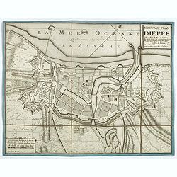
Nouveau plan de Dieppe, ville et port de mer de la Normandie.
Beautiful plan showing the fortified town of Dieppe and the suburbs of Barre and Pollet, engraved by Inselin. Beautiful example.
- $230 / ≈ €201
Date: Paris, ca. 1730
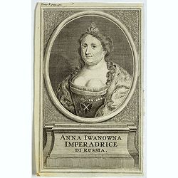
Anna Iwanowna Imperadrice di Russia.
Portrait of Anna Iwanowna (1693 – 1740), was regent of the duchy of Courland from 1711 until 1730 and then ruled as Empress of Russia from 1730 to 1740.
- $75 / ≈ €66
Date: France, ca. 1730
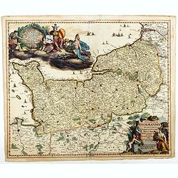
Nova et accurata Normandiae Ducatus Tabula . . .
This very rare map of Britany made by the Amsterdam publisher and Pieter Persoy (1675-1695). This among fourteen other maps are sometimes found in atlases by Frederik de ...
Date: Amsterdam, 1730
Bude Ville capitale de la Hongrie.
A rare panoramic town-view of the city of Budapest. Engraved by Pierre Aveline (Paris, c.1656 - 23 May 1722). He was also a print-publisher and print-seller. He probably...
- $400 / ≈ €349
Date: Paris, 1690-1730

Europe
A New Map of Europe according to ye Newest Observations (date ca.1730). Image size: 256mmm x 180mm.Herman Moll (1678-1732) was a German emigre from the Hanseatic port cit...
- $100 / ≈ €87
Date: London, ca. 1720-1730
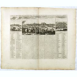
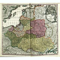
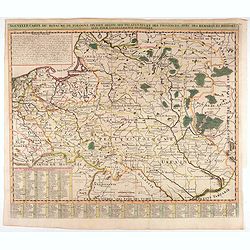
Carte Des Trois Ordres Qui Composent L'Etat De La Republique De Pologne...
Decorative views of Cracow, Warsaw and Vilna, from Chatelain's monumental Atlas Historique.It is an elaborate presentation of the political hierarchy of the Polish-Lithua...
Date: Paris, 1732
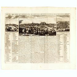
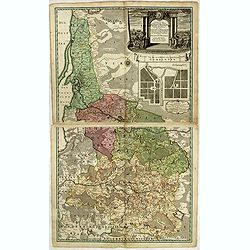
Carte Des Trois Ordres Qui Composent L'Etat De La Republique De Pologne...
Decorative views of Cracow, Warsaw and Vilna, from Chatelain's monumental Atlas Historique.Zacharie Chatelain (d.1723) was the father of Henri Abraham (1684-1743) and Zac...
- $800 / ≈ €699
Date: Amsterdam, 1732
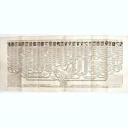
Nouvelle carte genealogique des souverains et des familles illustres aliez a la maison ou aux decendans de la famille roialle de Piaste roi de Pologne. . .
A two sheet engraving of the genealogical family tree of Poland from 804 AD to the time of publication. The tree extends throughout Europe and is headed by the arms of 30...
- $150 / ≈ €131
Date: Amsterdam, 1719-1732

Le Roi Henri II blassé a mort representanté dans son lit.
Print showing King Henry II in his death bed. In June 1559 a tournament lasting several days was held in Paris to celebrate a peace treaty between France and Spain. King ...
- $100 / ≈ €87
Date: Paris, 1729-1733
Nieuwe Kaart van Muskovie of Rusland..
Detailed map of European Russia, far south to the Black Sea and Caspian Sea. Isaac Tirion was born in Utrecht ca. 1705. He came to Amsterdam ca. 1725. Tirion published a ...
Date: Amsterdam, 1734
Nieuwe Kaart van Muskovie of Rusland.
Detailed map of European Russia, far south to the Black Sea and Caspian Sea. Isaac Tirion was born in Utrecht ca. 1705. He came to Amsterdam ca. 1725. Tirion published a ...
- $150 / ≈ €131
Date: Amsterdam, 1734
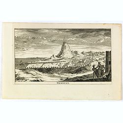
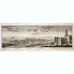
Derbent.
View of Derbent, the southernmost city in Russia from a scarce series of city views by Daniel de la Feuille (1640-1709). Engraving shows the ancient fortress and ruins of...
- $100 / ≈ €87
Date: Amsterdam, 1734
Das bombadirte Dantzig. Das belagerte Danzig eine Weltberühmte Haupt und Handelstatt des Polnischen Preussens, mit ihren Vorstaedten und der Weichselmünder Schanz,
Large original copper engraving with decorative set edge, top left Diarium of the Russian attack and Russian battleships in Gdansk Bay, above list of the most important b...
- $850 / ≈ €743
Date: Nuremberg, 1734
Poloniae Regnum ut et Magni Ducatus Lithuaniae . . .
Detailed map of Poland and the Baltic regions, extending in the south to Ukraine and northern Hungary.Here in its second state, now with added letters to the border scale...
- $750 / ≈ €655
Date: Augsburg, 1735
Potentissimo Borussorum Regi Friderico Wilhelmo Maiestate, Fortitudine Clementia Augustissimo Hancce Lithuaniam Borussicam : in qua luca coloniis Salisburg., ad incolendum Regio nutu concessa ...
Potentissimo Borussorum Regi Friderico Wilhelmo Maiestate, Fortitudine Clementia Augustissimo Hancce Lithuaniam Borussicam : in qua luca coloniis Salisburg., ad incolendu...
- $1500 / ≈ €1310
Date: Nuremberg, 1735
Nieuwe kaart van Muskovien door M. de l'Isle.
This lovely little map of the area surrounding Moscow is based on Delisle's map of the region. The map is bounded by Lake Ilmen in the north, the Volga River to the east,...
- $100 / ≈ €87
Date: Amsterdam, 1735
Potentissimo Borussorum Regi Friderico Wilhelmo Maiestate, Fortitudine Clementia Augustissimo Hancce Lithuaniam Borussicam : in qua luca coloniis Salisburg., ad incolendum Regio nutu concessa ...
Potentissimo Borussorum Regi Friderico Wilhelmo Maiestate, Fortitudine Clementia Augustissimo Hancce Lithuaniam Borussicam : in qua luca coloniis Salisburg., ad incolendu...
- $1200 / ≈ €1048
Date: Nuremberg, 1735
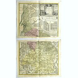
Nouvelle carte du royaume de Pologne, divisée selon..
Chatelain's map of Poland. The title is in two lines across the map. At the bottom border, an index to the map's contents appears. At the top of the map, historical remar...
Date: Amsterdam, 1735
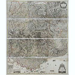
Theatre de la Guerre en Savoie et en Piémont - Le Dauphiné, La Bresse - Partie du Lionnois et de la Provence./ Theatre de la guerre en Dauphiné et en Provence…
Rare wall map of the Savoie/Piémont and Dauphiné/Provence region. Decorated with 2 title-cartouches, one at upper right part (Savoye/Piémont) and one at lower right pr...
- $3000 / ≈ €2621
Date: Amsterdam, c.1735
Ichnographia munitissimae Arcis Otzakoff quae Ao. 1737, die 3 Iulÿ auspicÿs Supremi Campi Mareschalli Comitis de Münnich ab exercitu Russorum vi occupata . . .
A striking image of this fortified Russian outpost on the Black Sea at Otzakoff, northeast of Odessa.
- $1100 / ≈ €961
Date: Augsburg, 1737
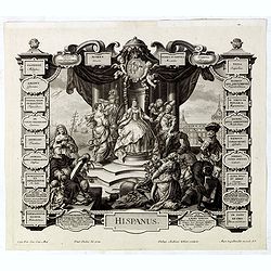
Hispanus.
Allegorical print of Spain (Hispanus), copper engraving after P. Decker by M. Engelbrecht. Taken from "Laconicum Europae Speculum". Philippe Andrea Kilian (1714...
Date: Augsburg, 1737
Prospectus Palatÿ Comitis Leopoldi de Windischgräz . . .
Very nice engraving by J.A. Corvinus after a design of Salomon Kleiner showing the house of an Austrian aristocratic family.
- $100 / ≈ €87
Date: Augsburg, 1737
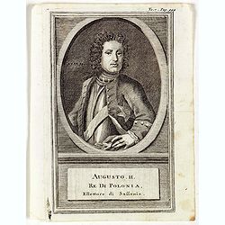
Augusti. II. Re di Polonia, Ellettore di Sassonia.
Portrait of Augustus II the Strong (12 May 1670 – 1 February 1733) of the Albertine line of the House of Wettin was Elector of Saxony (as Frederick Augustus I), Imperia...
Date: Venice, 1739
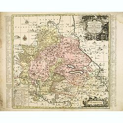
Nova Territorii Erfordien in suas praefecturas..
"Showing the area of Erfurt. In the lower part, there is a panoramic view of the town. Lower left and right splendid cartouches.The cartouches are painted in a stron...
Date: Nurenberg, 1740
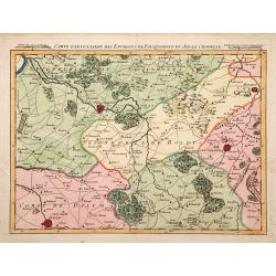
Carte particuliere des environs de Fauquemont et Aix la Chapelle.
An attractive map of the southern part of Limburg, centered on Valkenburg, Aachen, Rolduc and Dalem.
Date: Paris, 1740
Circulus Saxoniae inferioris.
Detailed map of Saxen, including Bremen, Berlin, Lübeck, etc. Johann Baptist Homann (1663-1724) was a German engraver and publisher, who established himself and his fami...
- $200 / ≈ €175
Date: Nuremberg 1740
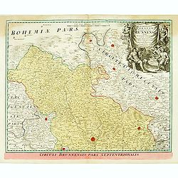
Marchionatus Moraviae circulus brunnensis. . .
Johann Baptist Homann's well-engraved map has a large decorative cartouche. Detailed map centered on Bruenn in Moravia. Prepared by Johann Chr. Mueller. Very decorative t...
- $300 / ≈ €262
Date: Nuremberg, 1740
Nova et accuratissima Maris Caspii. . .
Original hand colored copper engraving of Matthaeus Seutter. Showing the Caspian Sea with the large Volga Delta in east orientation. Main towns / countries around the Cas...
- $750 / ≈ €655
Date: Augsburg, 1740
Moscovia o Russia.
Map showing European Russia and is centered on Moscow. In the lower right corner, title cartouche with scale and the town of Astrakhan. From "Atlante Novissimo Che C...
Date: Venice, 1740
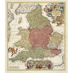
Magnae Britanniae pars meridionalis in qua regnum Angliae. . .
Johann Baptist Homann's well-engraved map has a large decorative cartouche at top right and a large scene at bottom center showing a throned ruler, presumably George I, h...
Date: Nuremberg, 1740
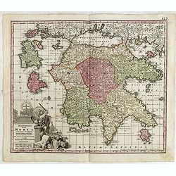
Peloponnesus Hodie Morea Ad Normam Veterum Et Recentiorum Mappa Accuratissime Adornata Aeri Incisa Et Venalis. . .
Decorative regional map of Morea and contiguous islands, with an ornate cartouche showing a lion bearing a sword defeating Turkish and other invaders.
- $450 / ≈ €393
Date: Augsburg, 1740
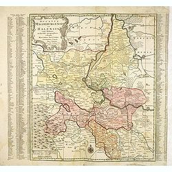
Ducatus Magdeburgensis Et Halensis cum finitimis Delineatio geographica. . .
Very decorative map centered on Magdeburg with Elbe river. With a key to the left and right of the map.
- $75 / ≈ €66
Date: Augsburg, ca. 1740
Delineatio geographica praefecturarum Wittebergensis et Graefenhaynichen; in circulo electorali sitarum. . .
Very decorative map of Mansfeld Land, a region in the southwestern corner of the German state of Saxony-Anhalt. The region derives its name from the counts of Mansfeld, w...
- $75 / ≈ €66
Date: Augsburg, ca. 1740
Delineatio geographica praefecturarum Wittebergensis, et Graefenhaynichen. . .
Showing Amt Wittenberge with the river Elbe. Wittenberge is a town of eighteen thousand people on the middle Elbe in the district of Prignitz, Brandenburg.
- $75 / ≈ €66
Date: Augsburg, 1740
Delineatio Geographica Ditionis Martisburgensis hodie regiis et electoralibus auspiciis florentis edita. . .
Map shows the surrounding of the city of Halle. With a very large title cartouche occupying the lower left corner. Engraved by Tobias Conrad Lotter.
- $75 / ≈ €66
Date: Augsburg, 1740
Praefecturae Principatus Querfurtensis Dahmiana et Iüterboccensis cum vicinia oppidis, vicis, pagis accurate distincta. . .
Showing the region of Ämter Dahme, Jüterbog, Baruth. With in the north Potsdam and in the south Schönwalde, in the west Brück/ Zahna and in the east Buchholz/ Luckau.
- $50 / ≈ €44
Date: Augsburg, ca. 1740
Moscoviae seu Russiae Magnae Generalis Tabula. . .
A scarce and attractive, wide-ranging map of incorporating Scandinavia, the Baltic countries, parts of Germany and Czechoslovakia, Poland, Hungary, Ukraine, Bulgaria, Nor...
- $1500 / ≈ €1310
Date: Augsburg, 1740
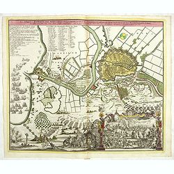
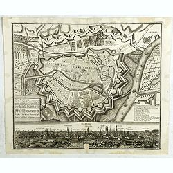
Accurata recens delineata ichnographia celeberrimæ liberæ Imperii civitatis ac Sueviæ metropolis Agustæ Vindelicorum -Neu verfertigt accurater ... Haupt Stadt Augspurg.
Superb plan of the fortified town of Augsburg, brilliantly colored at the time, with title in Latin and German. The plan was designed by Johann Thomas Kraus, engraver, ar...
- $1200 / ≈ €1048
Date: Nuremberg, ca. 1740
Fiorenza.
A spectacular largescale panoramic view of Florence taken from Montoliveto, with legends numbered from 1- 63 in Italian. With the title in a banderol. After a design by F...
Date: Augsburg, ca 1740
![[Portrait] - Me De Cet Corona se X+I. - Contantia et Fortudine](/uploads/cache/43510-250x250.jpg)
[Portrait] - Me De Cet Corona se X+I. - Contantia et Fortudine
Portrait of German Emperor Charles VI with his motto "Contantia et Fortudine". Holy Roman Emperor, 1711-1740, and King of Hungary as Charles III (1712-1740). Wi...
Date: Germany, 1740
![[Lot of 5 maps of the mouth of the Gironde river] Carte des Entrees et Cours de la Gironde](/uploads/cache/86010-250x250.jpg)
[Lot of 5 maps of the mouth of the Gironde river] Carte des Entrees et Cours de la Gironde
A large sea chart of the mouth and course of the Gironde river as far inland as Bordeaux. Decorated with three cartouches.Jacques Nicolas Bellin (1702-720) was the most i...
- $350 / ≈ €306
Date: Paris, c. 1740
Comitatus Stolbergici ad Hercyniam. . .
The County of Stolberg (Grafschaft Stolberg) was a county of the Holy Roman Empire located in the Harz mountain range in present-day Saxony-Anhalt, Germany. It was ruled ...
- $100 / ≈ €87
Date: Nuremberg, ca 1740
Dantiscum F. Gedanum celeberrimum . . .
Dantzig city plan with a bird-eye view of the city and the main monuments.Matthaus Seutter the elder first published his "Atlas Geographicus" in 1720 and added ...
Date: Augsburg, ca. 1740
