Browse Listings in Europe
![[ View of Cruzola]](/uploads/cache/45205-250x250.jpg)
[ View of Cruzola]
Very rare view of Tremite Islands Island published in the first edition of "Viaggio da Venetia, a Costantinopoli. Per Mare, e per Terra, & infieme quello di Terr...
Date: Venice, Giacomo Franco, 1598
![[ View of Ragusi]](/uploads/cache/45206-250x250.jpg)
[ View of Ragusi]
Very rare view of Ragusa published in the first edition of "Viaggio da Venetia, a Costantinopoli. Per Mare, e per Terra, & infieme quello di Terra Santa. Da Gios...
Date: Venice, Giacomo Franco, 1598
![Antivari [View of Bar in Montenegro]](/uploads/cache/45214-250x250.jpg)
Antivari [View of Bar in Montenegro]
Very rare view of Bar in Montenegro published in the first edition of "Viaggio da Venetia, a Costantinopoli. Per Mare, e per Terra, & infieme quello di Terra San...
Date: Venice, Giacomo Franco, 1598
![[View of Caorle].](/uploads/cache/45190-250x250.jpg)
[View of Caorle].
Very rare view of Caorle, at the time an island, published in the first edition of "Viaggio da Venetia, a Costantinopoli. Per Mare, e per Terra, & infieme quello...
Date: Venice, Giacomo Franco, 1598
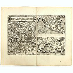
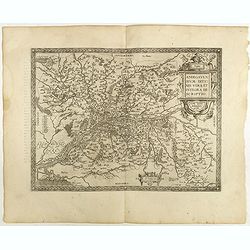
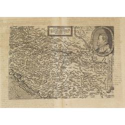
Carinthiae et Goritiae .. / Histria / Zarae / Serebenici. . .
Three maps on one sheet. The left-hand is centered on the eastern part of Austria. The upper right-hand map is centered on northern Yugoslavia, and the last map is center...
Date: Antwerp, 1598
![Valona [ View of Valona]](/uploads/cache/45215-250x250.jpg)
Valona [ View of Valona]
Very rare view of Vlora in Albania published in the first edition of "Viaggio da Venetia, a Costantinopoli. Per Mare, e per Terra, & infieme quello di Terra Sant...
Date: Venice, Giacomo Franco, 1598
![Fortezza Di Sopoto [Fortress of Sopot in Abania]](/uploads/cache/45216-250x250.jpg)
Fortezza Di Sopoto [Fortress of Sopot in Abania]
Very rare view of the Fortress of Sopot in Albania published in the first edition of "Viaggio da Venetia, a Costantinopoli. Per Mare, e per Terra, & infieme quel...
Date: Venice, Giacomo Franco, 1598
![Sopoto - Margaritino. [Sopot and Margarita in Albania]](/uploads/cache/45218-250x250.jpg)
Sopoto - Margaritino. [Sopot and Margarita in Albania]
Very rare view of Sopot and Margarita in Albania published in the first edition of "Viaggio da Venetia, a Costantinopoli. Per Mare, e per Terra, & infieme quello...
Date: Venice, Giacomo Franco, 1598
![[Map of Zakynthos or Zante]](/uploads/cache/45226-250x250.jpg)
[Map of Zakynthos or Zante]
Very rare map of Zakynthos or Zante, a Greek island in the Ionian Sea. It is the third largest of the Ionian Islands. Published in the first edition of "Viaggio da V...
- $450 / ≈ €393
Date: Venice, Giacomo Franco, 1598
![[Map of Morea]](/uploads/cache/45228-250x250.jpg)
[Map of Morea]
Very rare map of the island Morea published in the first edition of "Viaggio da Venetia, a Costantinopoli. Per Mare, e per Terra, & infieme quello di Terra Santa...
- $450 / ≈ €393
Date: Venice, Giacomo Franco, 1598
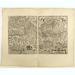
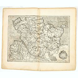
Helvetiae Descriptio . . .
A fine map based upon a map by the Swiss cartographer Aegidicus Tschudi of 1538.Dare to go in Black. All early maps are printed in black and white and many were kept that...
Date: Antwerp, 1598
Moraviae.
This early map of Slovakia was prepared by Paul Fabritius in 1569, centered on the city of Brno. Title cartouche on the upper left corner. Abraham Ortelius (1527-1598) wa...
Date: Antwerp, 1598

Romaniae, (quae olim Thracia dicta) ..
Very fine map centered on the Danube area. The map is based on the double sheet map by Jacob Gastaldi. Abraham Ortelius (1527-1598) was a cartographer and publisher, who ...
Date: Antwerp, 1598

Artois. Atrebatum Regionis Vera Descripto.
Prepared by Jacob Surhon, who made a manuscript map of Artois for which he received 36 Livres from Charles V in 1554. For security reasons, the map was not published. Onl...
Date: Antwerp, 1598
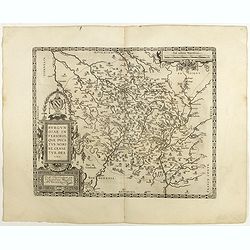
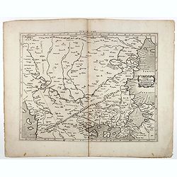
Regionis Biturigum... Per Ioannem Calamaeum. / Limaniae Topographia Gabriele Symeoneo Auct.
Two maps on one sheet. Biturigum. The Loire river is on the right in central France. Neuers (Nevers) is at the middle of the right margin. Bourges is near the center, and...
Date: Antwerp, 1598
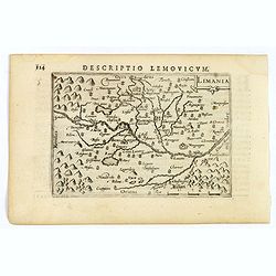
![Blaisois Blesiensis Territorii. . . [together with] - Lemovicum totius et confinium provinciarum. . .](/uploads/cache/40963-250x250.jpg)
Blaisois Blesiensis Territorii. . . [together with] - Lemovicum totius et confinium provinciarum. . .
The map on the left is centered on the Loire with the town of Blois. The right-hand map is centered on Limoges. Dare to go in Black. All early maps were printed in bla...
Date: Antwerp, 1598
Anjou. Andegavensium Ditionis Vera et Integra Descriptio. Licimo Guijeto Andegavense auctore.
Beautiful map of the Anjou region of western France along the Loire River. Include the city of Angers in the center. Accompanying French text on verso. Dare to go in B...
Date: Antwerp, 1598
Burgundiae inferioris quae Ducatus Nomine Censetur, Des.
Map centered on the province of Burgundy, from 'Theatrum Orbis Terrarum'.Dare to go in Black. All early maps were printed in black and white; many were kept that way for ...
- $100 / ≈ €87
Date: Antwerp, 1598
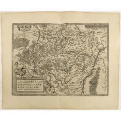
Lutzenburgen sis Ducatus Veriss. Descript.
An attractive map of Luxembourg: title cartouche on the lower left corner. From 'Theatrum Orbis Terrarum [Atlas of the Whole World]'.Iacobo Surhonio Montano auctore. D...
Date: Antwerp, 1598
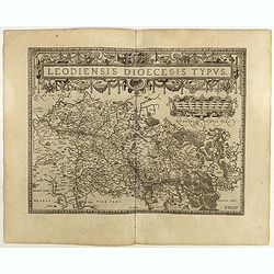
Leodiensis Diocesis Typus.
East to the top. Centered on Liege, including the southern part of Dutch Limburg. Prepared by Jan van Schille.Dare to go in Black. All early maps were printed in black an...
Date: Antwerp, 1598
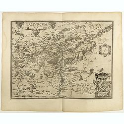
Namurcum Comitatus.
Prepared by Jacques Surhon in 1555. His manuscript map was, for security reasons not published. Only in 1579, when Antwerp was independent for a short time, Ortelius used...
Date: Antwerp, 1598

Angliae, scotiae, et Hiberniae, sive Britannicar:insularum.
Fine general map of the British Isles and Ireland on horizontal projection with north to right of page. Derived from Mercator's 1564 map of the British Isles.Dare to go i...
Date: Anwerp, 1598

Angliae Regni florentissimi nova descriptio..
Fine general map of England derived from Mercator's 1564 map of the British Isles in 8 sheets.Dare to go in Black. All early maps were printed in black and white; many we...
Date: Antwerp, 1598
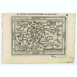
Oswiec. et Zatorien. Ducatus.
Miniature map of Poland from "Il Theatro del Mondo," which was a plagiarized version of Ortelius' pocket atlas published specifically for the Italian market by ...
- $200 / ≈ €175
Date: Brescia, 1598
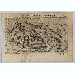
Castel Novo
Very rare view of Herceg-Novi, an important fortress belonging to Venetian Dalmatia captured during the 16th century by the Turks. Published in the first edition of "...
Date: Venice, Giacomo Franco, 1598
![Citta Di Trav [Trogir]](/uploads/cache/45200-250x250.jpg)
Citta Di Trav [Trogir]
Very rare map centered on the historic town of Trogir published in the first edition of "Viaggio da Venetia, a Costantinopoli. Per Mare, e per Terra, & infieme q...
- $300 / ≈ €262
Date: Venice, Giacomo Franco, 1598
![Spalato [ View of Split]](/uploads/cache/45201-250x250.jpg)
Spalato [ View of Split]
Very rare view of Split published in the first edition of "Viaggio da Venetia, a Costantinopoli. Per Mare, e per Terra, & infieme quello di Terra Santa. Da Giose...
- $450 / ≈ €393
Date: Venice, Giacomo Franco, 1598
![Liesena Isola [Hvar]](/uploads/cache/45202-250x250.jpg)
Liesena Isola [Hvar]
Very rare view map of the Island of Hvar published in the first edition of "Viaggio da Venetia, a Costantinopoli. Per Mare, e per Terra, & infieme quello di Terr...
- $400 / ≈ €349
Date: Venice, Giacomo Franco, 1598
![Glissa. [Klissza or Klis]](/uploads/cache/45203-250x250.jpg)
Glissa. [Klissza or Klis]
Very rare view of Klissza (Klis) published in the first edition of "Viaggio da Venetia, a Costantinopoli. Per Mare, e per Terra, & infieme quello di Terra Santa....
- $300 / ≈ €262
Date: Venice, Giacomo Franco, 1598
![Budova [Budua in Montenegro]](/uploads/cache/45209-250x250.jpg)
Budova [Budua in Montenegro]
Scarce map centered on Budua in Montenegro was published in the first edition of "Viaggio da Venetia, a Costantinopoli. Per Mare, e per Terra, & infieme quello d...
- $450 / ≈ €393
Date: Venice, Giacomo Franco, 1598
![[ Map with part of Albania]](/uploads/cache/45210-250x250.jpg)
[ Map with part of Albania]
Very rare view of part of the coast of Albania published in the first edition of "Viaggio da Venetia, a Costantinopoli. Per Mare, e per Terra, & infieme quello d...
- $450 / ≈ €393
Date: Venice, Giacomo Franco, 1598
![Dulcigno [Ulcinj in Montenegro]](/uploads/cache/45211-250x250.jpg)
Dulcigno [Ulcinj in Montenegro]
Very rare view of Ulcinj in Montenegro published in the first edition of "Viaggio da Venetia, a Costantinopoli. Per Mare, e per Terra, & infieme quello di Terra ...
- $450 / ≈ €393
Date: Venice, Giacomo Franco, 1598
![Durazo [ view of Durres in Albania]](/uploads/cache/45212-250x250.jpg)
Durazo [ view of Durres in Albania]
Very rare view of Durres in Albania published in the first edition of "Viaggio da Venetia, a Costantinopoli. Per Mare, e per Terra, & infieme quello di Terra San...
- $450 / ≈ €393
Date: Venice, Giacomo Franco, 1598
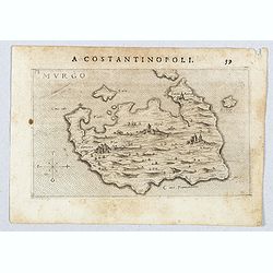
Murgo.
Very rare map of Amorgos published in the first edition of "Viaggio da Venetia, a Costantinopoli. Per Mare, e per Terra, & infieme quello di Terra Santa. Da Gios...
- $300 / ≈ €262
Date: Venice, Giacomo Franco, 1598
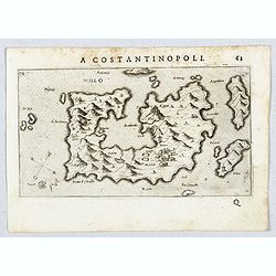
Millo.
Very rare view of Milos Island published in the first edition of "Viaggio da Venetia, a Costantinopoli. Per Mare, e per Terra, & infieme quello di Terra Santa. D...
- $450 / ≈ €393
Date: Venice, Giacomo Franco, 1598
![[View of Osero].](/uploads/cache/45194-250x250.jpg)
[View of Osero].
Very rare view of Osor published in the first edition of "Viaggio da Venetia, a Costantinopoli. Per Mare, e per Terra, & infieme quello di Terra Santa. Da Giosep...
- $400 / ≈ €349
Date: Venice, Giacomo Franco, 1598
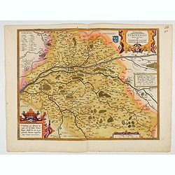
Touraine. Turonensis Ducatus.
Map of Touraine Duché in very fine original colours.
Date: Antwerp, 1598

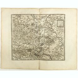
Regionis Biturigum... Per Ioannem Calamaeum. / Limaniae Topographia Gabriele Symeoneo Auct.
Two maps on one sheet. Biturigum. The Loire river is at the right in central France. Neuers (Nevers) is at the middle of the right margin. Bourges is near the center, an...
- $125 / ≈ €109
Date: Antwerp, ca. 1598
Mansfeldiae Comitatus.
A very fine map centered on the city of Mansfelt . A very nice title cartouche in the upper right corner. Signed by the engraver Franz Hogenberg lower left. Abraham Ortel...
- $75 / ≈ €66
Date: Antwerp, 1598
Basiliensis territorii descriptio nova./Circulus sue Liga. . .
Left-hand map centered on Basel, east to top. With credit to Sebastian Münster in the title cartouche. Right-hand map with Boden See, Strasbourg and Augsburg. The map wa...
- $300 / ≈ €262
Date: Antwerp, 1598
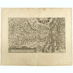
Palatinatvs Bavariae . . . / Argentoratensis agri . . .
From 'Theatrum Orbis Terrarum [Atlas of the Whole World]. The left-hand map of Bavaria is after Erhart Reych's 4-sheet map of 1540. Including the towns of Regensburg, Nü...
- $100 / ≈ €87
Date: Antwerp, 1598
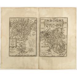
Buchaviae / Waldeccensis Comitatus.
Two maps on one sheet. The map on the left is based on Wolfgang Regerwyl's 1574 single fulda map. The map of Waldeck is based on Joist Moers map of 1572. Abraham Ortelius...
- $100 / ≈ €87
Date: Antwerp, 1598
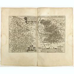
Braunsvicensis et Luneburgensis . . . (together with) Norimberg Agri,..
Two maps on one sheet, showing the regions of Braunschweig and Nuremberg from 'Theatrum Orbis Terrarum [Atlas of the Whole World]': published in Antwerp.Dare to go in Bla...
- $125 / ≈ €109
Date: Antwerp, 1598
Tab. IX Europae, Continens Daciam, Misiam, Thraciam, ac Macedoniae partem.
Map of Dacia, Thrace and Macedonia -- or Byzantium from the Black Sea west to Greece. Including the site of Constantinople / Istanbul, the Dardanelles, Bosphorus, etc. By...
- $400 / ≈ €349
Date: Amsterdam, c.1600
![Le Roy de Navarra venant à Paris recheut le coup de cousteau au visaige par ung Pierre Chastel, lequel par quatre chevaulx fut tiré en pièces, faict le 27 de Decemb[re] l'an 1594.](/uploads/cache/38548-250x250.jpg)
Le Roy de Navarra venant à Paris recheut le coup de cousteau au visaige par ung Pierre Chastel, lequel par quatre chevaulx fut tiré en pièces, faict le 27 de Decemb[re] l'an 1594.
Engraved news-sheet with text in German and French. Pictorial reportage on the failed assassination attempt on King Henri IV of France by Jean Châtel (here identified as...
Date: Cologne, ca. 1600
Sclavonia Croatia, Bosnia & Dalmatiae Pars Maior.
Mattheus Quadt's map of the western Balkan with a portrait of the Roma.Matthias Quadt (1557-1613) was a Dutch geographer who worked in Cologne. From "Geographisch ha...
- $500 / ≈ €437
Date: Cologne, 1600
Nova exactissimaque descriptio Danubii.
Rare loose impression of de Jode's map of the Danube with the surrounding countries with de Jode's imprint replaced by Theodor Galle's one. Without letterpress text on ve...
- $4000 / ≈ €3494
Date: Antwerp, 1600
Oswiecz et Zantor.
An attractive miniature map of Oswieczin and Zator in the Southern part of Poland, with major cities named. Strapwork title cartouche at the bottom. French text on verso....
- $125 / ≈ €109
Date: Antwerp, 1601
![[Nova Zembla]](/uploads/cache/44870-250x250.jpg)
[Nova Zembla]
Charming and decorative miniature map of the Russian island of Nowaya Zemlya. With the depiction of Barentsz.' route. With inset with 2 birds ("Loms Vögel oder Nort...
Date: Frankfurt am Main, 1604
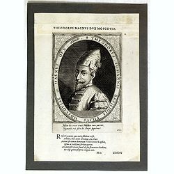
Theodorus Iohannis Basilidis Filius Moscoviae Magnus Dux / Atrium Heroicum.
Lettered with title around oval and two lines of Latin in lower margin: 'Mitior hic rexit ... / ... fato, de stirpe suprémus'. Lettered in letterpress above the platemar...
- $50 / ≈ €44
Date: Augsburg, 1601-1604
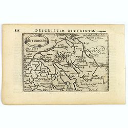
Descriptio Biturigum.
A charming small map of central France. Showing the areas around the rivers Loire, Auron, Allier and Yevre. Nevers and Bourges depicted. From the Bertius atlas Tabularum ...
- $100 / ≈ €87
Date: Amsterdam, 1606
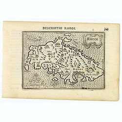
Rhodi.
A beautiful miniature map of the Greek island of Rhodes, published by Petrus Bertius in Amsterdam at the beginning of the seventeenth century.Engraved by Petrus Kaerius. ...
Date: Amsterdam, 1606
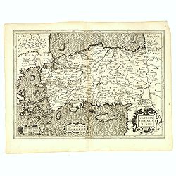
Natoliae Sive Asia Minor.
From the first edition. Map of Turkey, also depicting Cyprus.
Date: Amsterdam, 1606
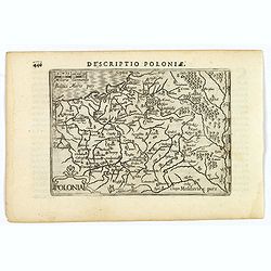
Polonia.
A miniature map of the Polish-Lithuanian Commonwealth, published by Petrus Bertius, in Amsterdam at the beginning of the seventeenth century. It features a small strap-wo...
Date: Amsterdam, 1606
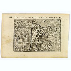
Hollandia Septentrionalis.
An attractive miniature map of the north Holland, northwards from Amsterdam to the Zijpe polder, published by Petrus Bertius, in Amsterdam at the beginning of the sevente...
Date: Amsterdam, 1606
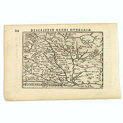
Hungaria.
A lovely miniature map of Hungary, published by Petrus Bertius, in Amsterdam at the beginning of the seventeenth century. There is a decorative strap-work title, and the ...
Date: Amsterdam, 1606
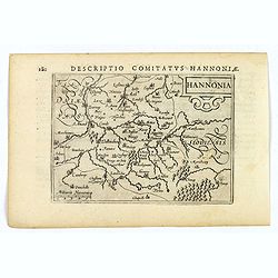
Hannonia.
An attractive miniature map of the Belgian, region of Hainaut, published by Petrus Bertius, in Amsterdam at the beginning of the seventeenth century. It features a small ...
Date: Amsterdam, 1606
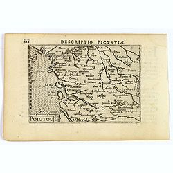
Descriptio Pictaviae.
A charming small map of Poitou in west central France. Showing Cognac, Limoges, Perigord, Poitiers and Angouleme. From the Bertius atlas Tabularum geographicarum contract...
Date: Amsterdam, 1606
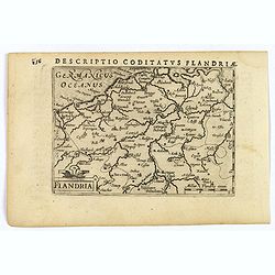
Flandria.
A lovely set of miniature map of Flanders. With an attractive strap-work title, and with detailed topography and information. Bertius (1565-1629) was a Flemish cartograph...
Date: Amsterdam, 1606
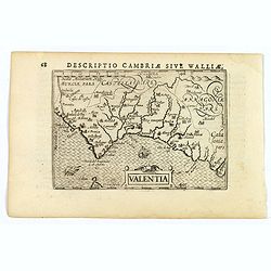
Valentia.
A fine miniature map of the Spanish province of Valencia, published by Petrus Bertius in Amsterdam early in the seventeenth century. The map features a nice strap-work ti...
Date: Amsterdam, 1606
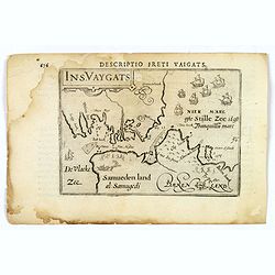
Descriptio Freti Vaigats.
Finely engraved map of the Vaigach Straits, from Bertius's rare miniature atlas. The map focuses on the straits between Novaya Zemlya and the Russian mainland, which had ...
- $150 / ≈ €131
Date: Amsterdam, 1606
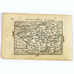
Descriptio Galliae.
A charming small map of ancient Gaul, France under Roman occupation. Featuring most major cities, rivers, mountains and regions are named. From the Bertius atlas Tabularu...
Date: Amsterdam, 1606
Malta.
A miniature map of the lovely Mediterranean island of Malta, published by Petrus Bertius in Amsterdam, at the beginning of the seventeenth century. An attractive small ma...
- $200 / ≈ €175
Date: Amsterdam, 1606
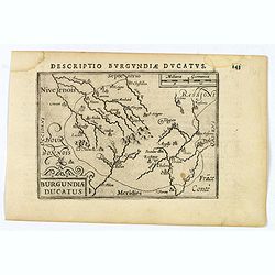
Descriptio Burgundiae Ducatus.
A decorative small map of region around Dijon, Chalons and Dole in Burgundy. Shows many rivers including the Seine, Saone and Brune. It features a nice strap-work title, ...
Date: Amsterdam, 1606
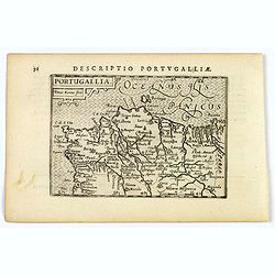
Portugallia.
A nice miniature map of Portugal, published by Petrus Bertius, in Amsterdam, at the beginning of the seventeenth century. North is orientated to the right. Strap-work tit...
Date: Amsterdam, 1606
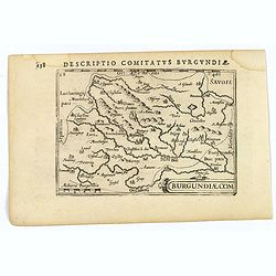
Descriptio Comitatus Burgundiae.
A decorative small map of region around Dijon, Halons and Dole in Burgundy. Features a nice strap-work title, shows rivers and settlements. From the Bertius atlas Tabular...
Date: Amsterdam, 1606
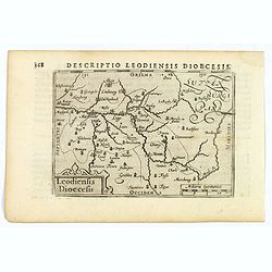
Descriptio Leodiensis Dioecesis.
A decorative map of the ancient Diocese of liege in Belgium, highlighting cities such as Huy, Liege, Tongeren (old capital), Namur and Maastricht. North is orientated to ...
- $100 / ≈ €87
Date: Amsterdam, 1606
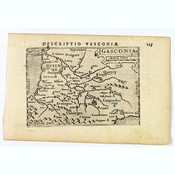
Gasconia.
A lovely miniature map of Gascony, in the S.W. region of France, published by Petrus Bertius, in Amsterdam at the beginning of the seventeenth century. There is a small s...
Date: Amsterdam, 1606
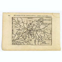
Aniou.
Anjou is a historical province of France, straddling the lower Loire River. Its capital was Angers. It bordered Brittany to the west, Maine to the north, Touraine to the ...
Date: Amsterdam, 1606
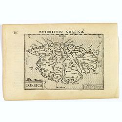
Corsica.
A fine miniature map of the French island of Corsica, published by Petrus Bertius in Amsterdam early in the seventeenth century. The map features a strap-work title carto...
Date: Amsterdam, 1606
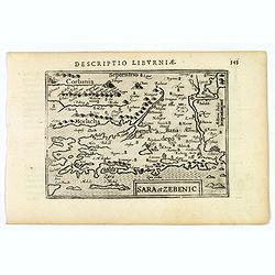
Sara et Zebenic.
A miniature map of Sara & Zebenic - in Croatia / Dalmatia in Eastern Europe, published by Petrus Bertius in Amsterdam, at the beginning of the seventeenth century. An...
- $100 / ≈ €87
Date: Amsterdam, 1606
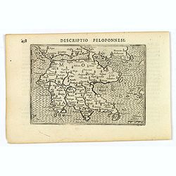
Descriptio Peloponnesi.
A fine miniature map of the southern Greek provence of Morea, the middle ages term for the Peloponnese peninsular, published by Petrus Bertius in Amsterdam early in the s...
- $100 / ≈ €87
Date: Amsterdam, 1606
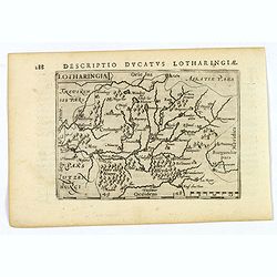
Lotharingia.
Lothringaria (Lorraine) is a historical province of N.E. France, it features the cities of Sarrebourg, Metz, Toul and Nancy. With excellent physical and topographical det...
- $100 / ≈ €87
Date: Amsterdam, 1606
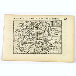
Tirolis Comita.
A lovely miniature map of the Tyrol region in the Alps, published by Petrus Bertius, in Amsterdam at the beginning of the seventeenth century. The map has a plain strap-w...
- $80 / ≈ €70
Date: Amsterdam, 1606
Holsatia ducatus.
Map of Holsatia. Including the town of Hamburg.Mercator was born in Rupelmonde in Flanders and studied in Louvain under Gemma Frisius, Dutch writer, astronomer and mathem...
- $150 / ≈ €131
Date: Amsterdam, 1606
![Descriptio Gadium [France].](/uploads/cache/43237-250x250.jpg)
Descriptio Gadium [France].
An attractive miniature map of France, published by Petrus Bertius, in Amsterdam at the beginning of the seventeenth century. Title in bold capital letters above map, sti...
Date: Amsterdam, 1606
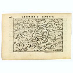
Helvetia.
A lovely miniature map of Switzerland, published by Petrus Bertius, in Amsterdam at the beginning of the seventeenth century.Full of facinating topographical detail, and ...
Date: Amsterdam, 1606
Limania.
A pleasant miniature map of the Limousin region of central France, the area surrounding Clermont Ferrand. Good map detail. From the Bertius atlas Tabularum geographicarum...
Date: Amsterdam, 1606
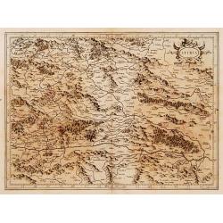
Stiria.
Detailed map of Stiria, the most eastern part of Austria, centered on Graz.Mercator was born in Rupelmonde in Flanders and studied in Louvain under Gemma Frisius, Dutch w...
Date: Amsterdam, 1606
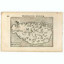
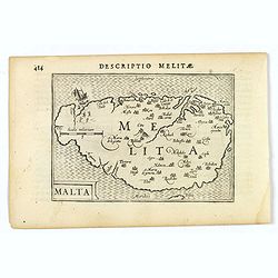
Descriptio Melitae / Malta.
A rare miniature map of Malta. Title cartouche on the lower left corner.First published in 1598 in his Caert-Thresoor, the plates were executed by the most famous engrave...
- $300 / ≈ €262
Date: Amsterdam, Cornelis Claes, 1606
