Browse Listings in Europe
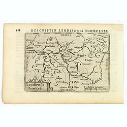
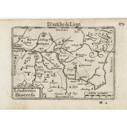
Descriptio Leodiensis Dioecesis.
A decorative map of the ancient Diocese of liege in Belgium, highlighting cities such as Huy, Liege, Tongeren (old capital), Namur and Maastricht. North is orientated to ...
- $100 / ≈ €87
Date: Amsterdam, 1606
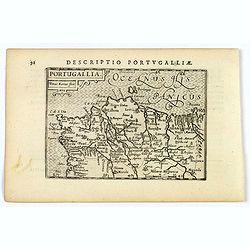
Portugallia.
A nice miniature map of Portugal, published by Petrus Bertius, in Amsterdam, at the beginning of the seventeenth century. North is orientated to the right. Strap-work tit...
Date: Amsterdam, 1606
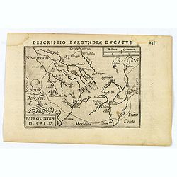
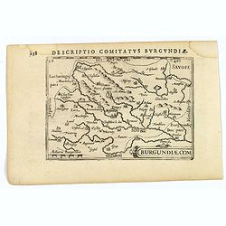
Descriptio Burgundiae Ducatus.
A decorative small map of region around Dijon, Chalons and Dole in Burgundy. Shows many rivers including the Seine, Saone and Brune. It features a nice strap-work title, ...
Date: Amsterdam, 1606
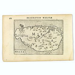
Malta.
A miniature map of the lovely Mediterranean island of Malta, published by Petrus Bertius in Amsterdam, at the beginning of the seventeenth century. An attractive small ma...
- $200 / ≈ €175
Date: Amsterdam, 1606
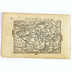
Descriptio Galliae.
A charming small map of ancient Gaul, France under Roman occupation. Featuring most major cities, rivers, mountains and regions are named. From the Bertius atlas Tabularu...
Date: Amsterdam, 1606
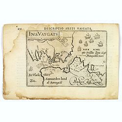
Descriptio Freti Vaigats.
Finely engraved map of the Vaigach Straits, from Bertius's rare miniature atlas. The map focuses on the straits between Novaya Zemlya and the Russian mainland, which had ...
- $150 / ≈ €131
Date: Amsterdam, 1606
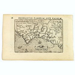
Valentia.
A fine miniature map of the Spanish province of Valencia, published by Petrus Bertius in Amsterdam early in the seventeenth century. The map features a nice strap-work ti...
Date: Amsterdam, 1606
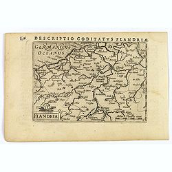
Flandria.
A lovely set of miniature map of Flanders. With an attractive strap-work title, and with detailed topography and information. Bertius (1565-1629) was a Flemish cartograph...
Date: Amsterdam, 1606
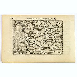
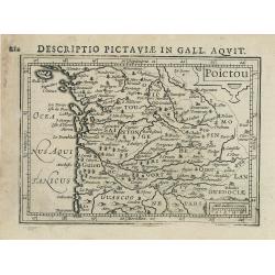
Descriptio Pictaviae.
A charming small map of Poitou in west central France. Showing Cognac, Limoges, Perigord, Poitiers and Angouleme. From the Bertius atlas Tabularum geographicarum contract...
Date: Amsterdam, 1606
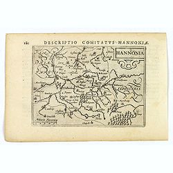
Hannonia.
An attractive miniature map of the Belgian, region of Hainaut, published by Petrus Bertius, in Amsterdam at the beginning of the seventeenth century. It features a small ...
Date: Amsterdam, 1606
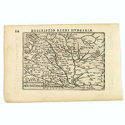
Hungaria.
A lovely miniature map of Hungary, published by Petrus Bertius, in Amsterdam at the beginning of the seventeenth century. There is a decorative strap-work title, and the ...
Date: Amsterdam, 1606
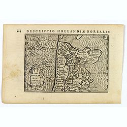
Hollandia Septentrionalis.
An attractive miniature map of the north Holland, northwards from Amsterdam to the Zijpe polder, published by Petrus Bertius, in Amsterdam at the beginning of the sevente...
Date: Amsterdam, 1606
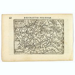
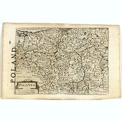
Polonia.
A miniature map of the Polish-Lithuanian Commonwealth, published by Petrus Bertius, in Amsterdam at the beginning of the seventeenth century. It features a small strap-wo...
Date: Amsterdam, 1606
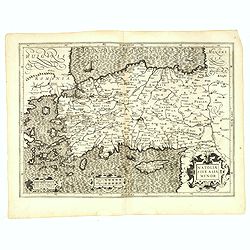
Natoliae Sive Asia Minor.
From the first edition. Map of Turkey, also depicting Cyprus.
Date: Amsterdam, 1606
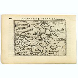
Descriptio Biturigum.
A charming small map of central France. Showing the areas around the rivers Loire, Auron, Allier and Yevre. Nevers and Bourges depicted. From the Bertius atlas Tabularum ...
- $100 / ≈ €87
Date: Amsterdam, 1606
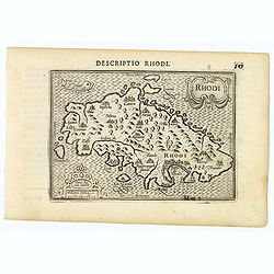
Rhodi.
A beautiful miniature map of the Greek island of Rhodes, published by Petrus Bertius in Amsterdam at the beginning of the seventeenth century.Engraved by Petrus Kaerius. ...
Date: Amsterdam, 1606
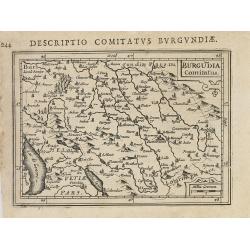
Descriptio Comitatus Burgundiae.
A decorative small map of region around Dijon, Halons and Dole in Burgundy. Features a nice strap-work title, shows rivers and settlements. From the Bertius atlas Tabular...
Date: Amsterdam, 1606
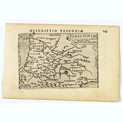
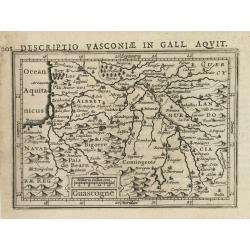
Gasconia.
A lovely miniature map of Gascony, in the S.W. region of France, published by Petrus Bertius, in Amsterdam at the beginning of the seventeenth century. There is a small s...
Date: Amsterdam, 1606
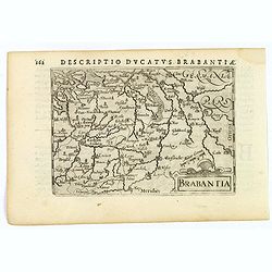
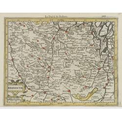
Brabantia.
A lovely miniature map of the Duchy of Brabant, published by Petrus Bertius, in Amsterdam at the beginning of the seventeenth century. There is a nice, small strap-work t...
Date: Amsterdam, 1606
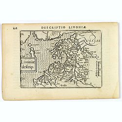
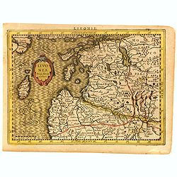
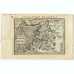
Livoniae descrip.
An attractive miniature map of the Baltic region of Livonia, as it was at the beginning of the seventeenth century, and published by Petrus Bertius in Amsterdam. The map ...
Date: Amsterdam, 1606
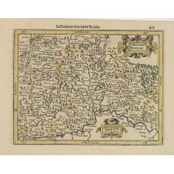
Palatinat. Bavariae.
Detailed map showing part of Bavaria. It covers the area between Ingolstadt, Nuremberg and Regensburg.From the first French-text edition of Jodocus Hondius' Atlas Minor.S...
- $50 / ≈ €44
Date: Amsterdam, 1608
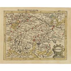
Bavaria.
Detailed map showing part of Bavaria. It covers the area between Ingolstadt and Salzburg.From the first French-text edition of Jodocus Hondius' Atlas Minor.Shortly after ...
- $50 / ≈ €44
Date: Amsterdam, 1608
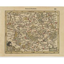
Brauswik et Meydburg com confinijs.
Detailed map showing the region around Brunswick and Magdeburg. With major cities of the area named.From the first French-text edition of Jodocus Hondius' Atlas Minor.Sho...
- $50 / ≈ €44
Date: Amsterdam, 1608
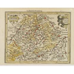
Wirtenberg.
Detailed map centered on Baden-Württemberg. With major cities of the area named.From the first French-text edition of Jodocus Hondius' Atlas Minor. Shortly after the p...
- $40 / ≈ €35
Date: Amsterdam, 1608
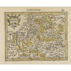
Waldek Comit.
Early map of the region surrounding Waldeck, northern Hessen. From the first French-text edition of Jodocus Hondius' Atlas Minor.Shortly after the publication of the big ...
- $45 / ≈ €39
Date: Amsterdam, 1608
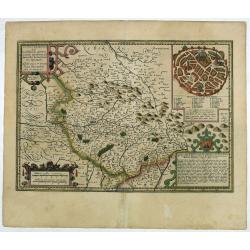
Totius Lemovici et . . .
Map of part of France, centered on Limoge, including a plan of Limoge. Prepared by Jean du Fayen (1530-1612), French physician and geographer, who prepared the first know...
Date: Amsterdam, 1608
Livonia.
Scarce miniature map of Lithuania, from the first French-text edition of Jodocus Hondius' Atlas Minor. Engraved by Pieter Van Den Keere.Shortly after the publication of t...
- $300 / ≈ €262
Date: Amsterdam, Cloppenburgh, 1608
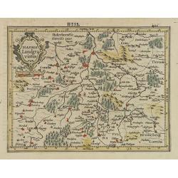
Hassia Landgraviatus.
Detailed map showing the region around Kassel. With major cities of the area named.From the first French-text edition of Jodocus Hondius' Atlas Minor.Shortly after the pu...
- $50 / ≈ €44
Date: Amsterdam, 1608
Brabantia.
Decorative regional map of northern Belgium and the Dutch province Brabant, extending north to Breda and south to Namur, with Antwerp and Brussels near the center.Oriente...
- $150 / ≈ €131
Date: Amsterdam, 1608

Pascaarte van een deel der Oost Zee, tusschen Bornholm ende der Memel, vertonende de ware gelegentheijt der Zeecusten van Pruijssen. . .
This very rare chart of the Northern Coast of Poland with Gdansk, appeared in the rare English edition of Willem Blaeu's 'Het Licht der Zeevaert', an atlas of sea charts ...
- $4000 / ≈ €3494
Date: Amsterdam, 1608
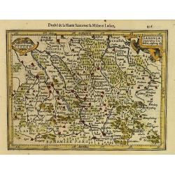
Saxoniae Superioris Lusatiae..
Detailed map of Saxony. With Prague at the bottom. From the first French-text edition of Jodocus Hondius' Atlas Minor.Shortly after the publication of the big folio-atlas...
- $50 / ≈ €44
Date: Amsterdam, 1608
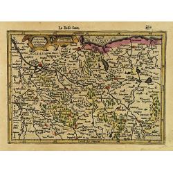
Saxonia Inferior et Mekleburg.
Detailed map showing part of northern Germany. With major cities of the area named.From the first French-text edition of Jodocus Hondius' Atlas Minor.Shortly after the pu...
Date: Amsterdam, 1608
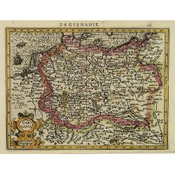
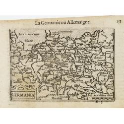
La Germanie.
Small map of Germany, including Austria and part of Poland. Strap work title cartouche in the lower left.From the first French-text edition of Jodocus Hondius' Atlas Mino...
- $75 / ≈ €66
Date: Amsterdam, 1608
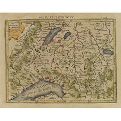
Das Wiflispurgergou.
Reduced version of Mercator''s map of the southwestern part of Switzerland. Shows Geneva, Lake Geneva, Lake Neuchatel, Lake Biel, Bern, Freiburg, Lake Thuner, etc.From th...
- $75 / ≈ €66
Date: Amsterdam, 1608
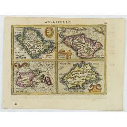
Anglesey Ins. / Wight.. / Ins. Garnesey. / Ins. Iarsey.
A reduced version of Mercator's folio map with four maps on one sheet depicting the English islands of Jersey, Guernsey, Wright and Alderney.Each map is embellished with ...
- $150 / ≈ €131
Date: Amsterdam, 1608
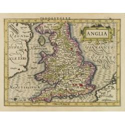
Anglia.
Map of England, from the first French-text edition of Jodocus Hondius'' Atlas Minor.Shortly after the publication of the big folio-atlases the need was apparently felt fo...
- $150 / ≈ €131
Date: Amsterdam, 1608
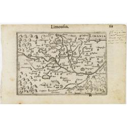
Limania / Limousin.
A miniature map of the Limousin. Fine cartouche in the upper right corner.First published in 1598 in his Caert-Thresoor, the plates were executed by the most famous engra...
Date: Amsterdam / Frankfurt, 1609
Germania.
A miniature map of Germany. The title cartouche on the lower left corner. First published in 1598 in his Caert-Thresoor, the plates were executed by the most famous engra...
- $75 / ≈ €66
Date: Amsterdam/Frankfurt, 1609
Leodiensis Dioecesis.
A miniature map of the southern part of Belgium centered on Liege. The title cartouche on the lower left corner.First published in 1598 in his Caert-Thresoor, the plates ...
- $75 / ≈ €66
Date: Amsterdam / Frankfurt, 1609
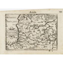
Artesia / Artois.
A miniature map including northern part of France. Title cartouche on the left side.First published in 1598 in his Caert-Thresoor, the plates were executed by the most fa...
Date: Amsterdam/Frankfurt 1609
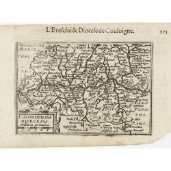
Coloniensis Diocesis.
A miniature map centered on Cologne. Title cartouche on the lower left corner.First published in 1598 in his Caert-Thresoor, the plates were executed by the most famous e...
- $80 / ≈ €70
Date: Amsterdam / Frankfurt, 1609
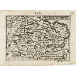
Hassiae Descriptio / Hesse.
A miniature map centered on the province of Hessen. The title cartouche on the upper right corner.First published in 1598 in his Caert-Thresoor, the plates were executed ...
- $50 / ≈ €44
Date: Amsterdam / Frankfurt, 1609
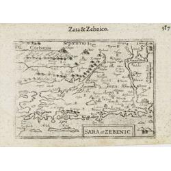
Sara et Zebenic.
A miniature map of the islands of Dalmatia. Title cartouche on the lower left side.First published in 1598 in his Caert-Thresoor, the plates were executed by the most fam...
- $100 / ≈ €87
Date: Amsterdam / Frankfurt, 1609
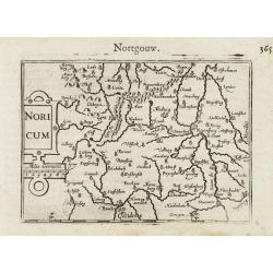
Noricum.
A miniature map showing a part of Bavaria, including the cities of Bamberg and Nuremberg. Title cartouche on the left side.First published in 1598 in his Caert-Thresoor, ...
- $50 / ≈ €44
Date: Amsterdam / Frankfurt, 1609
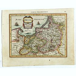
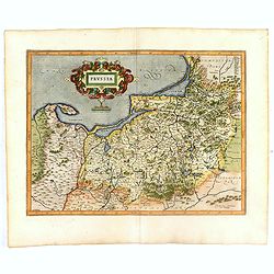
Prussia .
An early map of northern Poland from the "Atlas Minor" (Gerhard Mercator / Jodocus Hondius). Extends from Memel to Torun and the Narew River. With two sailing s...
- $300 / ≈ €262
Date: Amsterdam, 1612

Sardinia / Sicilia.. / Corfu / Zerbi.. / Elba / Malta. . .
Six very fine and early maps on one sheet. Including the islands of Sicily, Corfu, Sardinia, Zerbi (Djerba), Elba and Malta.The map of Malta has a sinking ship at Cala di...
Date: Antwerp, 1570-1612
Prussia .
Important early map showing coast of Baltic Sea in Prussia, today Poland, prepared by the German cartographer Gaspher Henneberg of Erlich. Embellished with a large strapw...
Date: Amsterdam, 1612
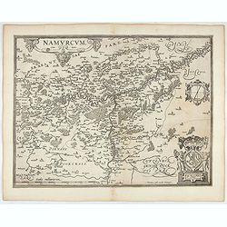
Namurcum Comitatus.
Prepared by Jacques Surhon in 1555. His manuscript map was for security reason not published. Only in 1579, when Antwerp was independent for a short time, Ortelius used a...
- $500 / ≈ €437
Date: Antwerp, after 1612
Artois. Atrebatum Regionis Vera Descripto.
Prepared by Jacob Surhon who made a manuscript map of Artois for which he received 36 Livres from Charles V in 1554. For security reasons the map was not published. Only ...
- $500 / ≈ €437
Date: Antwerp, after 1612
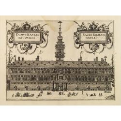
Domus Hansae Teutonicae / Sacri Romani Imperii. (Antwerp townhall)
From Ludovico Guicciardini.'s description of the Netherlands "Beschrijvinghe van alle de Nederlanden anderssins ghenoemt Neder-Duytslandt", published by Willem ...
- $100 / ≈ €87
Date: Amsterdam, 1612
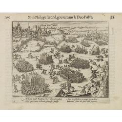
Auriaco infaelix Roermonda. . .
Showing the siege in May 1572 of Roermond.
- $100 / ≈ €87
Date: Amsterdam, 1612
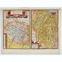
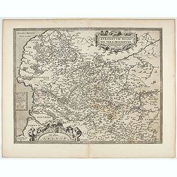
Burgundiae Ducatus. Burgundiae Comitatus.
Separately issued map of Burgundy area. Two maps of Burgundy region on a plate. Separately published map, without text on the verso. Second state with the date 1597 remov...
Date: Antwerp, after 1612
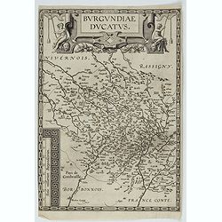
Burgundiae Ducatus.
Map of Burgundy region without text on the verso. Second state with the date 1597 removed from the title cartouche. This is the rarest Burgundy map of the four that Ortel...
- $500 / ≈ €437
Date: Antwerp, after 1612
Polonia et Silesia. (With text page)
Early map of Poland. With English title above the map and an description of the region in English on verso.
- $250 / ≈ €218
Date: Amsterdam, 1612
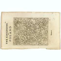
Polonia. (With text page)
Early map of Poland (168x250mm.) printed on a text page, together with another giving a description of the region in English.
- $150 / ≈ €131
Date: Amsterdam, 1612
Gelriae, Cliviae, Finitimorumque Locorum Verissima Descriptio.
From the very rare Galle edition of the Ortelius Atlas, published after 1612. Fine map of Geldria and Limburg, prepared by Christian s'Grooten. Very fine title cartouche ...
Date: Antwerp, after 1612
Provinciae, Regionis Galliae, vera exactissimaq. descriptio. Provence Petro Ioanne Bomparioo auctore.
A finely engraved map of the Province prepared by Pierre-Jean de Bompar who published a single sheet map of the Province in 1591. Title cartouche in the upper left-hand c...
- $500 / ≈ €437
Date: Amsterdam, 1613
![Description de tovts les Pays-Bas, autrement appellez, la Germanie Inferieure, ov Basse Allemagne / par Messire Loys Gvicciardin [...]](/uploads/cache/48781-250x250.jpg)
Description de tovts les Pays-Bas, autrement appellez, la Germanie Inferieure, ov Basse Allemagne / par Messire Loys Gvicciardin [...]
Fine early edition of the French oblong edition of this famous description of the Low Countries. For the French edition most plates are newly engraved by Petrus Kaerius.....
- $3500 / ≈ €3057
Date: Arnhem, Janssonius, J.,1613
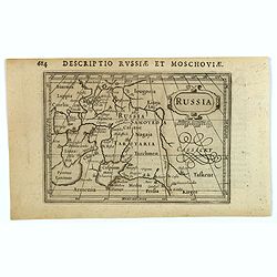
Russia.
Centered on Moscow, with the southern reaches of the map showing Persia, Armenia and Tashkent, the Black and Caspian Seas, and northward to Lapland and the frozen arctic ...
- $200 / ≈ €175
Date: Amsterdam, 1616
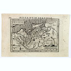
Descriptio Borussiae.
Fine miniature map of Prussia, now-a-day Poland. Bertius was a Flemish theologian, historian, geographer and cartographer. This little copperplate gem was engraved by van...
- $150 / ≈ €131
Date: Amsterdam, 1616
Gallia. Nova Galliae descriptio . . .
Very rare and early map of France with figures on three sides with views of cities, portraits (Henri IV and Marie de Medicis) and costumes. The map was directly influence...
Date: Amsterdam, 1616
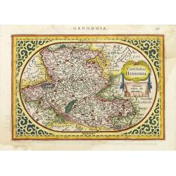
Comitatus Hannonia.
Detailed map of the Belgium province Hainault or Henegouwen. Including the towns of Mons, Geraadsbergen, etc.Uncommon and decorative oval map in a rectangular frame, the ...
- $100 / ≈ €87
Date: Amsterdam, 1616
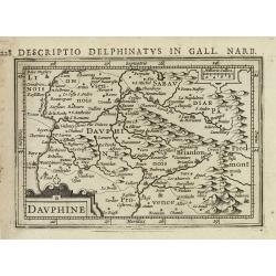
Dauphiné.
Text in Latin on verso.
- $80 / ≈ €70
Date: Amsterdam, 1616-1618
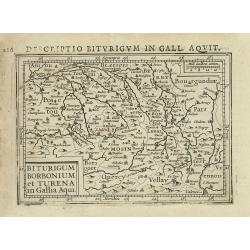
Biturigum borbonium et Turena in Gallia Aqui.
Text in Latin on verso.
- $80 / ≈ €70
Date: Amsterdam, 1616-1618
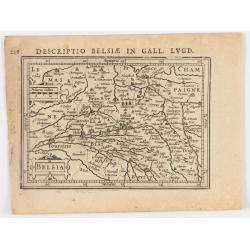
Belsia.
Text in Latin on verso.
- $80 / ≈ €70
Date: Amsterdam, 1616-1618
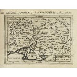
Comit. Avenionensis.
Text in Latin on verso.
- $100 / ≈ €87
Date: Amsterdam, 1616-1618
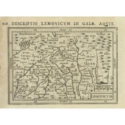
Lemovicum.
Text in Latin on verso.
- $80 / ≈ €70
Date: Amsterdam, 1616-1618
Poictou.
Text in Latin on verso.
Date: Amsterdam, 1616-1618
Guascogne.
Text in Latin on verso.
Date: Amsterdam, 1616-1618
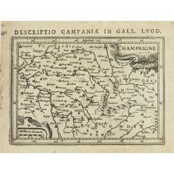
Champaigne.
Text in Latin on verso.
Date: Amsterdam, 1616-1618
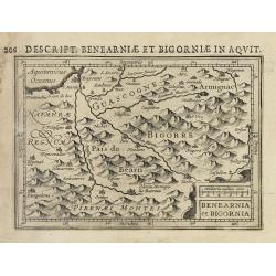
Benearnia et Bigornia.
Text in Latin on verso.
Date: Amsterdam, 1616-1618
Burgundia Comitatus
Text in Latin on verso.
- $80 / ≈ €70
Date: Amsterdam, 1616-1618
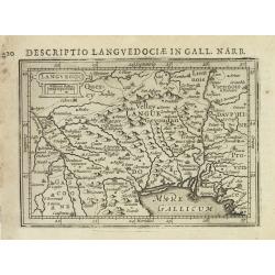
Languedoc.
Text in Latin on verso.
- $100 / ≈ €87
Date: Amsterdam, 1616-1618
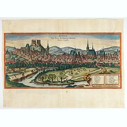
Brunn Vulgo Brinn Marchionatus Moraviae Civitas insignis.
Fine view of Brno seen from the southeast. TRANSLATION OF CAPTION: Brunn, in the vernacular Brno, eminent city in the Margravate of Moravia.COMMENTARY BY BRAUN: "Brn...
- $500 / ≈ €437
Date: Cologne, 1618
![Prospectus amoeniss. vallis Oeniponticae una cum antro in altissima et praeruptissima rupe Imp. Maximiliani primi. [on sheet with:] Schlosberg. die Clause in Alpibus Tirolensibus. ..](/uploads/cache/47903-250x250.jpg)
Prospectus amoeniss. vallis Oeniponticae una cum antro in altissima et praeruptissima rupe Imp. Maximiliani primi. [on sheet with:] Schlosberg. die Clause in Alpibus Tirolensibus. ..
Three views by Braun and Hogenberg: View of the Innvalley; view of the "Schlosberg" and a view of a monument for the emperor Carolus V.CAPTION: Prospect of the ...
- $350 / ≈ €306
Date: Cologne, 1618
Livoniae Descrip.
A rare miniature map of the Baltic States Estonia, Latvia & Lithuania. The present map is one of the earliest obtainable maps to focus this region. Title cartouche o...
- $200 / ≈ €175
Date: Amsterdam, 1618
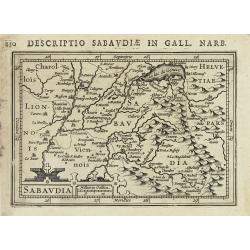
Sabaudia.
Text in Latin on verso.
- $100 / ≈ €87
Date: Amsterdam, 1616-1618
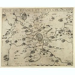
![[Lot of 17 maps] L' ISLE DE FRANCE Pariensis agri descriptio. Francois de la Hoeye fecit, Jean le Clerc excud.](/uploads/cache/19592-250x250.jpg)
[Lot of 17 maps] L' ISLE DE FRANCE Pariensis agri descriptio. Francois de la Hoeye fecit, Jean le Clerc excud.
The map of Ile de France which Jean Leclerc added in his re-issue of Maurice Bouguereau's atlas 'Theatre Francois' , as ' La Theatre geographique de France' in 1619. An u...
- $1000 / ≈ €874
Date: Paris, 1619
![[Lot of 6 Maps of Germany] PALATINATUS BAVARIAE.](/uploads/cache/IMG_2319-250x250.jpg)
[Lot of 6 Maps of Germany] PALATINATUS BAVARIAE.
[Lot of 6 Maps of Germany]- Palatinatus Bavariae. (H.Hondius & G.Mercator) circa. 1619 (490x370 mm)- La Basse Partie Du Cercle Du Haut Rhein divisé en tous ses ...
- $750 / ≈ €655
Date: Amsterdam, 1619
L'Isle de France / Parisiensis agri descrip.
Adorned with a title cartouche and a framing border. Leclerc's "Theatre geographique de France" is an extension of Bouguereau's "Theatre". A refugee w...
Date: Paris, ca. 1619
