Browse Listings in Asia

Terra Sancta.
This is the most modern of Ortelius' maps of the Holy Land. It focuses specifically on the Holy Land and is oriented with east of the top. Ortelius used as a model the wa...
Date: Antwerp, 1603
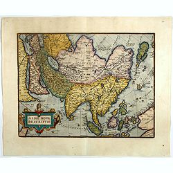
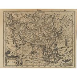
Asiae nova descriptio.
Ortelius' fine map of Asia well represents the continent at a time when Europeans were expanding their power in the Far East. The Indian subcontinent and Malaysian penins...
- $2250 / ≈ €1965
Date: Antwerp, 1603
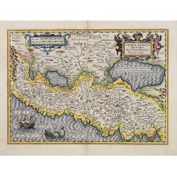
Terra Sancta quae in Sacris Terra Promissionis ol: Palestina.
Map of Palestine on both sides of the Jordan, the shore line running from Berithus (Beirut) to Gaza.Oriented to the east.Largely based on Ortelius 1584 map. In lower left...
- $675 / ≈ €590
Date: Amsterdam, 1606
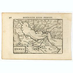
Descriptio Regni Ormuzii / Ormus.
A lovely miniature map of the Kingdom of Ormus, published by Petrus Bertius, and published in Amsterdam at the beginning of the seventeenth century. With an attractive st...
- $450 / ≈ €393
Date: Amsterdam, Cornelis Claes, 1606
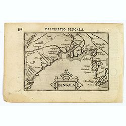
Bengala.
A lovely miniature map of a section of the Bay of Begal, published by Petrus Bertius, in Amsterdam at the beginning of the seventeenth century. There is a decorative stra...
Date: Amsterdam, 1606
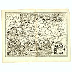
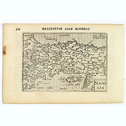
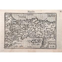
Natoliae Sive Asia Minor.
From the first edition. Map of Turkey, also depicting Cyprus.
Date: Amsterdam, 1606
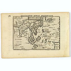
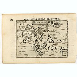
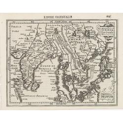
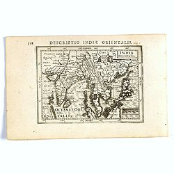
India Orientalis.
This lovely miniature map shows the East Indies, stretching from Persia to China and Japan, down to Java, and part of Papua new Guinea. Published by Petrus Bertius, in Am...
Date: Amsterdam, 1606
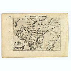
Descriptio Cambaiae.
A very decorative little map of northern India with Gujarat and the Indus river, bordering Pakistan. Naming major towns represented by symbols, major rivers, mountains, a...
- $100 / ≈ €87
Date: Amsterdam, 1606
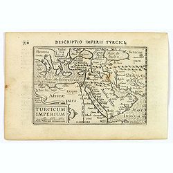
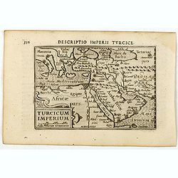
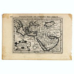
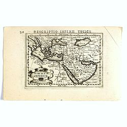
Turcicum Imperium.
A really attractive miniature map of The Turkish Empire, as it was at the beginning of the seventeenth century. Published by Petrus Bertius in Amsterdam. The map stretche...
Date: Amsterdam, 1606
India Orien.
A miniature map showing India and the islands of Borneo, New Guinea, Sumatra, Java, etc.Korea as an enlonged peninsular and one town marked.First published in 1598 in his...
- $400 / ≈ €349
Date: Amsterdam, Cornelis Claes, 1606
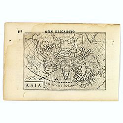
Asia.
A miniature map of the continent of Asia, published by Petrus Bertius in Amsterdam, at the beginning of the seventeenth century. An attractive small map featuring hatchin...
- $250 / ≈ €218
Date: Amsterdam, 1606
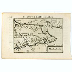
Malabar.
Very fine early miniature map of southern part of India and a part of Ceylon island. Title cartouche on the lower right corner.First published in 1598 in his Caert-Threso...
- $200 / ≈ €175
Date: Amsterdam, Cornelis Claes, 1606
Descriptio Imperii Turcici / Turcicum Imperium.
A rare miniature map of the Arabian Peninsular. Title cartouche on the lower right corner.First published in 1598 in his Caert-Thresoor, the plates were executed by the m...
- $300 / ≈ €262
Date: Amsterdam, Cornelis Claes, 1606
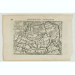
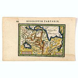
Descriptio Tartariae / Tartaria.
A rare miniature map of Tartary and China, showing the Great Wall. Title cartouche on the upper left corner.First published in 1598 in his Caert-Thresoor, the plates were...
- $300 / ≈ €262
Date: Amsterdam, Cornelis Claes, 1606

Descriptio Arabie / Arabia.
A rare miniature map of the Arabian Peninsular. The title cartouche on the lower right corner.First published in 1598 in his Caert-Thresoor, the plates were executed by t...
Date: Amsterdam, Cornelis Claes, 1606
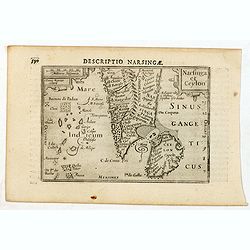
Descriptio Narsingae / Narsinga et Ceylon.
A rare miniature map of the southern part of India with Sri Lanka. The title cartouche on the upper right corner.First published in 1598 in his Caert-Thresoor, the plates...
- $350 / ≈ €306
Date: Amsterdam, Cornelis Claes, 1606
Natolia.
A miniature map of Turkish Natolia, published by Petrus Bertius in Amsterdam, at the beginning of the seventeenth century. This attractive small map features hatching in ...
- $150 / ≈ €131
Date: Amsterdam, 1606
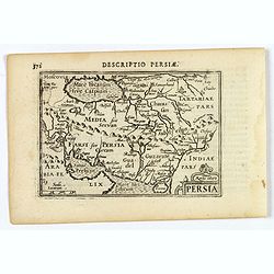
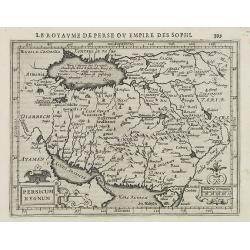
Persia.
A decorative miniature map of Persia, stretching from the Tigris River in the west to the Indus River in the east. As far north as the Caspian Sea. Published by Petrus B...
- $175 / ≈ €153
Date: Amsterdam, 1606
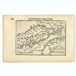
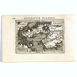
Malacca.
A nice miniature map of Malacca, A Malaysian state on the southern Malay peninsular, next to the Strait of Malacca. North is orientated to the left Published by Petrus B...
- $300 / ≈ €262
Date: Amsterdam, 1606
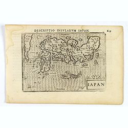
Iapon.
An attractive miniature map of Japan, published by Petrus Bertius, in Amsterdam at the beginning of the seventeenth century.The quirky map is shows the country in a disto...
- $250 / ≈ €218
Date: Amsterdam, 1606
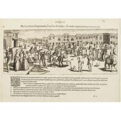
De foro Goae frequentato..
An attractive panorama view of the market square at Goa, with Indians and Portuguese traders, buying and selling various merchandise, with a row of colonial buildings in ...
Date: Frankfurt, 1607
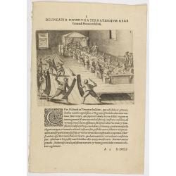
I. Delineatio convivii a Ternatensium rege Generali Neccio exhibiti.
This famous and desirable scene from Roelof Roelofsz's narrative of a voyage by J.C. van Neck to Ternate.Theodore de Bry, a German engraver and book dealer, began a compi...
- $100 / ≈ €87
Date: Frankfurt, Wolfgangi Richteri, 1607
Asia.
Map of Asia with an oversized Korea and a curious shape for Japan, from the first French-text edition of Jodocus Hondius' Atlas Minor.Shortly after the publication of the...
Date: Amsterdam, 1608
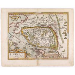
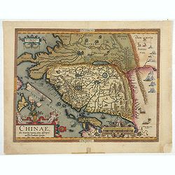
Chinae, olim Sinarum regionis. . .
The first printed map of China. It is signed by Ludovico Georgio, whose real name was Luis Jorge de Barbuda. He was a Portuguese Jesuit cartographer and besides that a sp...
- $6000 / ≈ €5241
Date: Antwerp, 1608
Indiae Orientalis.
This map covers an area including India, part of Malaysia, Borneo and China.From the first French-text edition of Jodocus Hondius' Atlas Minor.Shortly after the publicati...
Date: Amsterdam, 1608
Persicum Regnum.
Early map of Persia, from the first French-text edition of Jodocus Hondius' Atlas Minor.Shortly after the publication of the big folio-atlases the need was apparently fel...
Date: Amsterdam, 1608
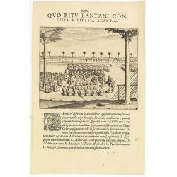
XXV. Quo Ritu Bantani Concilia Militaria Agant. 19. (Councils meeting at Bantam)
Councils meeting at Bantam (Banten), a city and former sultanate on Java island. Theodore de Bry, a German engraver and book dealer, began a compilation of early voyages ...
- $100 / ≈ €87
Date: Frankfurt, 1609
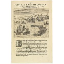
XVI. Civitas Bantam Tormentis nostris oppugnata . . .
Attack of Bantam (Banten), a city and former sultanate on Java island.Theodore de Bry, a German engraver and book dealer, began a compilation of early voyages in 1590 and...
- $100 / ≈ €87
Date: Frankfurt, 1609
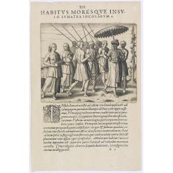
Habitus Moresque Insulae Sumatra Incolarum. (People of Sumatra)
People of Sumatra.Theodore de Bry, a German engraver and book dealer, began a compilation of early voyages in 1590 and had published six parts at the time of his death in...
- $100 / ≈ €87
Date: Frankfurt, 1609
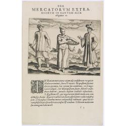
Mercatorum Extra. Neorum in Bantam Alia. Effigiatio. (People of Malacca)
People of Malacca.Theodore de Bry, a German engraver and book dealer, began a compilation of early voyages in 1590 and had published six parts at the time of his death in...
- $100 / ≈ €87
Date: Frankfurt, 1609
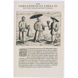
Mercatorum Ex China in Bantam Negotiantium Schema.
An early portrait of Chinese merchants in Banten (Bantam), a small port town near Java's western end.Theodore de Bry, a German engraver and book dealer, began a compilati...
- $100 / ≈ €87
Date: Frankfurt, 1609
Natolia.
A miniature map of the Arabian peninsula, including Cyprus. The title cartouche on the lower right corner.First published in 1598 in his Caert-Thresoor, the plates were e...
- $200 / ≈ €175
Date: Amsterdam / Frankfurt, 1609
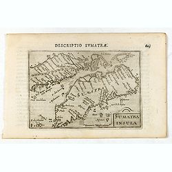
Sumatra Insula.
A miniature map of Sumatra containing detailed geography and nomenclature around the entire island. The neighbouring coast of the Malay Peninsula is shown, including Sing...
- $450 / ≈ €393
Date: Amsterdam/Frankfurt 1609
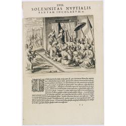
Solemnitas Nuptialis Bantam Incolarum. (A wedding ceremony in the city of Bantam)
When a young couple become engaged they do not leave their homes until the wedding takes place. On their wedding day they are dressed up and happy, and visited by all the...
- $75 / ≈ €66
Date: Frankfurt, 1609
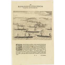
IX. Repraesentatio Piscationum Diurnarum.
Fishing offshore at the coasts of Guinea. Theodore de Bry, a German engraver and book dealer, began a compilation of early voyages in 1590 and had published six parts at ...
- $75 / ≈ €66
Date: Frankfurt, 1609
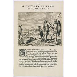
Milites in Bantam Gregarii Gum Suis armis. (Warriors of Bantam)
The warriors of Bantam carry both small and large shields made of leather, also swords or long lances with sturdy spear-heads. Their clothing is made with little square p...
- $75 / ≈ €66
Date: Frankfurt, 1609
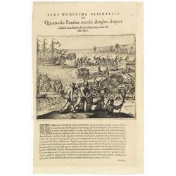
Pars Undecima Orientalis III. Quomodo Pembae incolae Anglos aliquot. . .
Finely engraved view of the arrival of Europeans at Pemba iIsland in Zanziba.Theodore de Bry, a German engraver and book dealer, began a compilation of early voyages in 1...
- $100 / ≈ €87
Date: Frankfurt, 1609
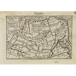
Tartaria.
A miniature map showing China, Korea and Russia. Title cartouche on the upper left corner.First published in 1598 in his Caert-Thresoor, the plates were executed by the m...
Date: Amsterdam, 1609
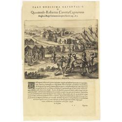
Pars Undecima Orientalis II. Quomodo Robertus, Caverta Capitaneus.
Fine engraving showing the arrest of the English captain Robert Caverta. Below an explanation in Latin that Caverta was arrested and killed by order of the king of the Co...
- $100 / ≈ €87
Date: Frankfurt, 1609
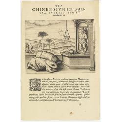
Chinensium in Bantam Superstitio et idololatria. 18. ( How the Chinese worship their idols in Bantam)
How the Chinese worship their idols in Bantam. As can be seen here, the Chinese worship their idol, which takes the form of a devil. They lay offerings of fruit on an alt...
- $100 / ≈ €87
Date: Frankfurt, 1609
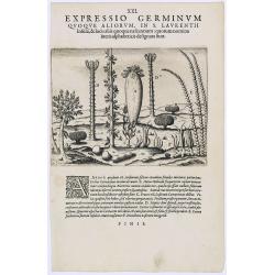
Expressio Germinum Quoque Aliorum, in S. Lavrentii.
Plants found in the island of S. Laurenti [Madagascar]. A’ denotes a tree with only a few twigs on the top. From this tree, canoes and boats are made. ‘B’ is a bush...
- $100 / ≈ €87
Date: Frankfurt, 1609
![[Description de la Figure de la ville de Gammelamme - Description du N° 15]](/uploads/cache/43504-250x250.jpg)
[Description de la Figure de la ville de Gammelamme - Description du N° 15]
View of the town of Gammelamme [Gamalama] on Ternate, where the Dutch established a trading post. Text engraving from "Premier livre de l'histoire de la navigation a...
- $50 / ≈ €44
Date: Amsterdam, Cornille Nicolas, 1609
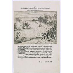
Delineatio Foederis Hollandorum cum Rege Calecutanorum pacti.
A treaty between the Dutch and the king of Calicut. The Dutch Admiral, Steffan van der Haagen already knew that the people of Calicut, on the Malabar Coast of India, were...
- $100 / ≈ €87
Date: Frankfurt, 1609
![[Java Fruits].](/uploads/cache/37933-250x250.jpg)
[Java Fruits].
Text engraving of fruits on Java from "Premier livre de l'histoire de la navigation aux Indes Orientales, par les hollandois, et des choses a eux advenues . . . &qu...
- $75 / ≈ €66
Date: Amsterdam, Cornille Nicolas, 1609
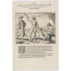
Indianorum, Insulae Pugnatan Incolarum. (The natives of the island of Pugnatan)
There was an island called Pugnatan at the western entrance to the Strait of Sudan, where the natives went about completely naked. Like the natives of Brazil, their hair ...
- $100 / ≈ €87
Date: Frankfurt, 1609
![[Tropical fruits of Java].](/uploads/cache/37934-250x250.jpg)
[Tropical fruits of Java].
Two text engravings of fruits on Java from "Premier livre de l'histoire de la navigation aux Indes Orientales, par les hollandois, et des choses a eux advenues . . ....
- $75 / ≈ €66
Date: Amsterdam, Cornille Nicolas, 1609
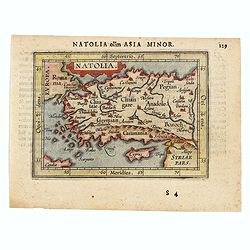
Natolia olim Asia Minor.
Genuine antique map "Natolia" by Abraham Ortelius from Epitome Theatri Orbis Terrarum, published in Antwerp in 1609. This charming 400-year-old miniature copper...
- $200 / ≈ €175
Date: Antwerp, 1609
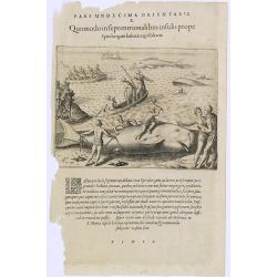
Pars Undecima Orientalis X. Quomodo in Septentrionalibus insulis prope. (How the inhabitants catch whales off the east coast of Madagascar.)
How the inhabitants catch whales off the east coast of Madagascar. When the natives of Santa Marta, off the east coast of Madagascar see a whale, they row out in their li...
- $100 / ≈ €87
Date: Frankfurt, 1609
![[View of the arrival of Cornelis de Houtman's fleet at Bantam, Java.].](/uploads/cache/37937-250x250.jpg)
[View of the arrival of Cornelis de Houtman's fleet at Bantam, Java.].
Engraved map of Bantam on Java with a lettered key (A-N) showing the arrival of Cornelis de Houtman’s fleet at Bantam, Java in 1596. Houtman’s four vessels, the Amste...
- $200 / ≈ €175
Date: Amsterdam, Cornille Nicolas, 1609
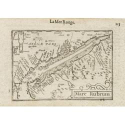
Mare Rubrum / Mer Rouge.
Wonderful miniature map includes the Red Sea, Yemen, and the east coast of the Arabian peninsula. One of the early maps to focus on this area. The title cartouche on the ...
Date: Amsterdam / Frankfurt, 1609
![[Bantam]](/uploads/cache/37939-250x250.jpg)
[Bantam]
Two text engravings from "Premier livre de l'histoire de la navigation aux Indes Orientales, par les hollandois, et des choses a eux advenues . . . ", being the...
- $100 / ≈ €87
Date: Amsterdam, Cornille Nicolas, 1609
![[Chinese Merchants and temple].](/uploads/cache/37966-250x250.jpg)
[Chinese Merchants and temple].
Two text engravings of Chinese merchants on Java and a Chines temple from "Premier livre de l'histoire de la navigation aux Indes Orientales, par les hollandois, et ...
- $100 / ≈ €87
Date: Amsterdam, Cornille Nicolas, 1609
![[Native Flora of Java].](/uploads/cache/37964-250x250.jpg)
[Native Flora of Java].
Text engraving of native flora of Java from "Premier livre de l'histoire de la navigation aux Indes Orientales, par les hollandois, et des choses a eux advenues . . ...
- $75 / ≈ €66
Date: Amsterdam, Cornille Nicolas, 1609
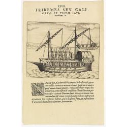
XXVII. Triremes seu Galiottae et Fustae Iavenenfium. 21. ( A typical Javanese man-of-war ship)
A typical Javanese man-of-war ship. The Javanese call their man-of-war ships, Cathurs. The slaves are all seated below deck and do the rowing with oars, while the warrior...
- $150 / ≈ €131
Date: Frankfurt, 1609
![Repraesentatio Aedificiorum in Benyn, et Quid Praeterea notatu dignum ibi occurrat. [Execution of criminals in Benin.]](/uploads/cache/29834-250x250.jpg)
Repraesentatio Aedificiorum in Benyn, et Quid Praeterea notatu dignum ibi occurrat. [Execution of criminals in Benin.]
Execution of criminals in Benin. According to the text: The town of Benin is quite large and comprises homes with no windows, only open roofs. The more distinguished hous...
- $100 / ≈ €87
Date: Frankfurt, 1609
![[Bantam].](/uploads/cache/37941-250x250.jpg)
[Bantam].
Text engraving showing the arrival of the Dutch fleet at Bantam from "Premier livre de l'histoire de la navigation aux Indes Orientales, par les hollandois, et des c...
- $150 / ≈ €131
Date: Amsterdam, Cornille Nicolas, 1609
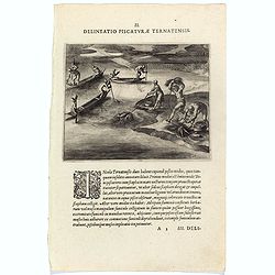
Delineatio Piscationum Ternatensis.
Fishing scene on Ternate island, Maluku, Indonesia.Theodore de Bry, a German engraver and book dealer, began a compilation of early voyages in 1590 and had published six ...
- $80 / ≈ €70
Date: Frankfurt, 1609
![[Foreign Merchants at Bantam].](/uploads/cache/37943-250x250.jpg)
[Foreign Merchants at Bantam].
Two text engravings from "Premier livre de l'histoire de la navigation aux Indes Orientales, par les hollandois, et des choses a eux advenues . . . ", being the...
- $100 / ≈ €87
Date: Amsterdam, Cornille Nicolas, 1609
![[Bantam].](/uploads/cache/37963-250x250.jpg)
[Bantam].
Text engraving showing some merchants of Bantam, from "Premier livre de l'histoire de la navigation aux Indes Orientales, par les hollandois, et des choses a eux adv...
- $75 / ≈ €66
Date: Amsterdam, Cornille Nicolas, 1609
![[Sumatra]](/uploads/cache/37955-250x250.jpg)
[Sumatra]
Text engraving from "Premier livre de l'histoire de la navigation aux Indes Orientales, par les hollandois, et des choses a eux advenues . . . ", being the clas...
- $50 / ≈ €44
Date: Amsterdam, Cornille Nicolas, 1609
![[Javanese Vessels]](/uploads/cache/37947-250x250.jpg)
[Javanese Vessels]
Two text engravings from "Premier livre de l'histoire de la navigation aux Indes Orientales, par les hollandois, et des choses a eux advenues . . . ", being the...
- $100 / ≈ €87
Date: Amsterdam, Cornille Nicolas, 1609
![[Dutch ship Amsterdam].](/uploads/cache/37948-250x250.jpg)
[Dutch ship Amsterdam].
Text engraving of the Dutch vessel Amsterdam offshore the island of Java near Surabaya from "Premier livre de l'histoire de la navigation aux Indes Orientales, par l...
Date: Amsterdam, Cornille Nicolas, 1609
![[Ternate].](/uploads/cache/37954-250x250.jpg)
[Ternate].
Text engraving showing a bay on the Island of Ternate, an island in the Maluku Islands (Moluccas) of eastern Indonesia. Above the map a lettered key (A-E). Text engraving...
- $100 / ≈ €87
Date: Amsterdam, Cornille Nicolas, 1609
![[Sunda].](/uploads/cache/37956-250x250.jpg)
[Sunda].
Text engraving and coastal profiles in wood block from "Premier livre de l'histoire de la navigation aux Indes Orientales, par les hollandois, et des choses a eux ad...
Date: Amsterdam, Cornille Nicolas, 1609
![[Ambon].](/uploads/cache/37953-250x250.jpg)
[Ambon].
Text engraving showing a bay on the Island of Ambon, an island in the Maluku Islands (Moluccas) of eastern Indonesia. Above the map a lettered key (A-D). Text engraving f...
- $150 / ≈ €131
Date: Amsterdam, Cornille Nicolas, 1609
![[Plants and fruits of the East Indies].](/uploads/cache/37951-250x250.jpg)
[Plants and fruits of the East Indies].
Two text engravings from "Premier livre de l'histoire de la navigation aux Indes Orientales, par les hollandois, et des choses a eux advenues . . . ", being the...
- $50 / ≈ €44
Date: Amsterdam, Cornille Nicolas, 1609
![[Celebrating the arrival of the Dutch in Turban].](/uploads/cache/37949-250x250.jpg)
[Celebrating the arrival of the Dutch in Turban].
Text engravings of a tournament in Turban. On 23rd January 1599, the Dutch landed at Turban (on the north coast of Java) with several small boats. Great crowds of people ...
- $150 / ≈ €131
Date: Amsterdam, Cornille Nicolas, 1609
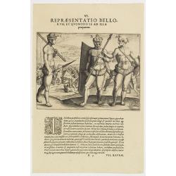
VI. Repraesentatio Bellorum, et Quomodo se ad Illa praeparent. (How the natives fight each other)
This shows how the men go to war and which weapons they use. They hold large square shields, about six feet high and four feet wide, made of cane and fortified with ox-hi...
- $90 / ≈ €79
Date: Frankfurt, 1609
![[Javanese gamelan orchestra]](/uploads/cache/37960-250x250.jpg)
[Javanese gamelan orchestra]
Two text engravings from "Premier livre de l'histoire de la navigation aux Indes Orientales, par les hollandois, et des choses a eux advenues . . . ", being the...
- $75 / ≈ €66
Date: Amsterdam, Cornille Nicolas, 1609
Natoliae Sive Asia Minor.
Map of Turkey, also depicting Cyprus.
- $750 / ≈ €655
Date: Amsterdam, 1610

Tartariae sive Magni Chami Imperium.
This is a very early depiction of the northern Pacific, with the first mapping of Northwest Coast of America and probably the first map to name California 'C. Califormio...
- $2500 / ≈ €2184
Date: Antwerp, c. 1608-1612
Chinae, olim Sinarum Regionis, nova descriptio. Auctore Ludovico Georgio.
The first map of China ever to appear in a Western atlas, west to the top. When this map appeared, it was by far the most accurate one of China.The map is based on a manu...
- $5500 / ≈ €4805
Date: Antwerp, 1608 /1612
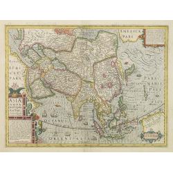
Asiae Nova Descriptio. . .
Several sources appear to have been used in the compilation of this map, including the Portuguese Jesuits Luis Teixeira (1595) for Japan, and Luis Jorgede Barbuda (1584) ...
- $3000 / ≈ €2621
Date: Amsterdam, 1613
Turcicum Imperium.
FIRST IMPRINT FROM THE NEWLY ENGRAVED PLATES IN 1616. - A rare miniature map of the Arabian Peninsular. Title cartouche on the lower left corner.First published in 1598 i...
- $500 / ≈ €437
Date: Amsterdam, J. Hondius, 1616
India Orientalis.
FIRST IMPRINT FROM THE NEWLY ENGRAVED PLATES IN 1616. - A rare miniature map of the East Indies.First published in 1598 in his Caert-Thresoor, the plates were executed by...
Date: Amsterdam, J. Hondius, 1616
Malacca.
FIRST IMPRINT FROM THE NEWLY ENGRAVED PLATES IN 1616. - A rare miniature map of Malacca, Borneo, part of Sumatra . Latin text on verso.First published in 1598 in his Caer...
Date: Amsterdam, J. Hondius, 1616
Turicum imperium.
FIRST IMPRINT FROM THE NEWLY ENGRAVED PLATES IN 1616. - A rare miniature map of the Ottoman empire with Turkey and the Arabian Peninsular. Title cartouche on the lower le...
Date: Amsterdam, J. Hondius, 1616
Tartaria.
An original early 17th century copper engraved miniature antique map of Tartary, China and part of America by Petrus Bertius.The title is displayed in a strap work cartou...
- $150 / ≈ €131
Date: Amsterdam, J.Hondius, 1618
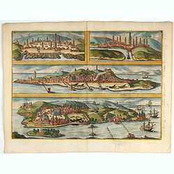
Casablanca (Anfa) - Azemmour (Azamor) - Diu - Old Goa (Velha Goa)
Four fine coastal views of these harbors cities which were important to Portuguese trade. Goa and Diu on the western coast of India, together with Anfa (Casablanc) and Az...
- $450 / ≈ €393
Date: Cologne, 1618
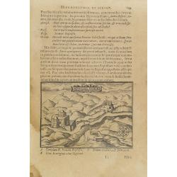
Montana Ivdeae. . .
Text page with copper engraved illustration of Mount Judea taken from Itinerarium Hierosolymitanum et Syriacum, in quo variarum Gentium Mores et Institua insularum, regio...
- $80 / ≈ €70
Date: Antwerp, Verdussen, 1619
