1618 BRAUN, G. / HOGENBERG, F. - Casablanca (Anfa) - Azemmour (Azamor) - Diu - Old Goa (Velha Goa)
Casablanca (Anfa) - Azemmour (Azamor) - Diu - Old Goa (Velha Goa)
| Maker: | BRAUN, G. / HOGENBERG, F. | |
| Date: | Cologne, 1618 | |
| Colored: | In attractive colors. | |
| Size: | 340 x 465 mm / 13.4 x 18.3 inches | |
| Condition: | Very good condition. Attractive colors. | |




Description
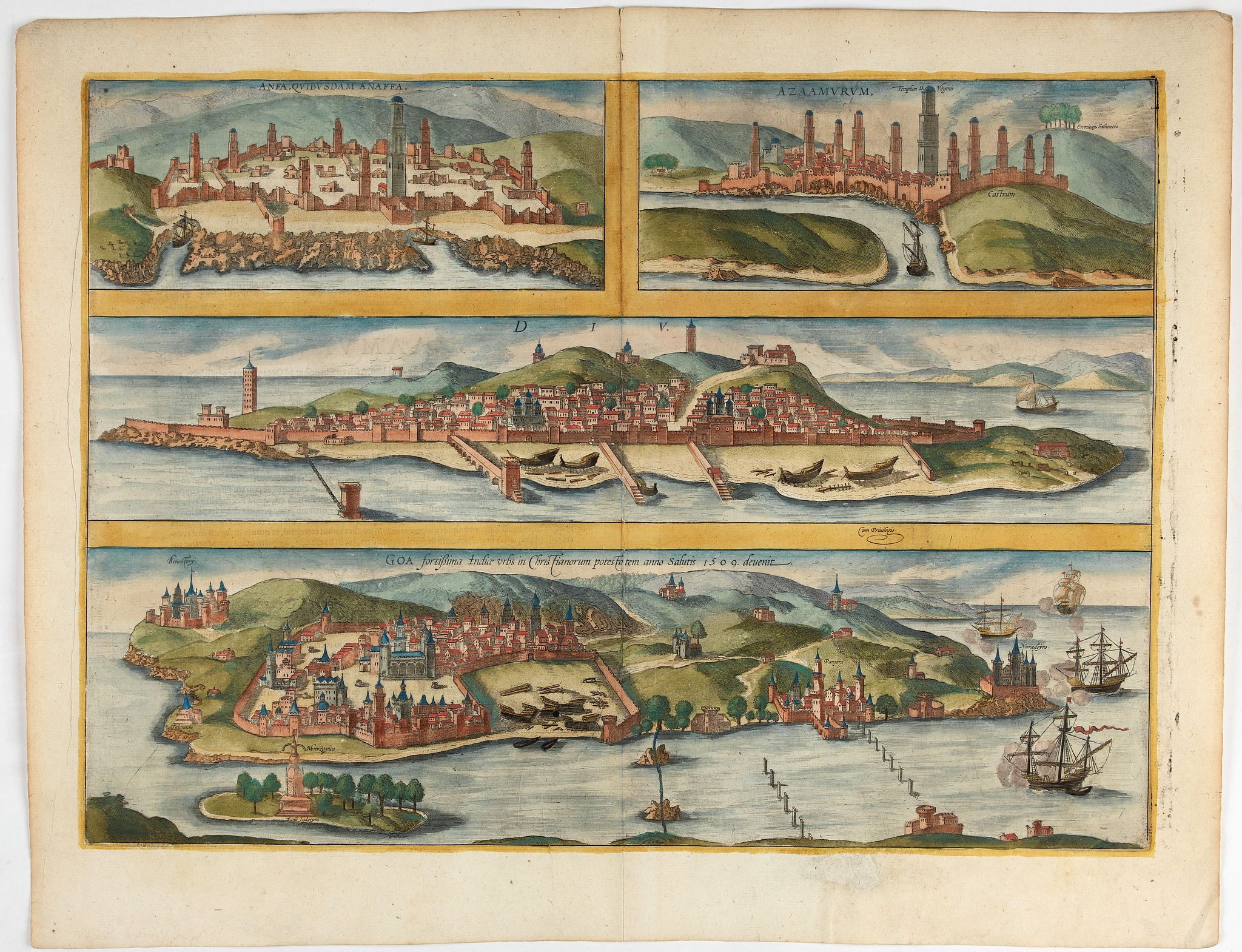
Four fine coastal views of these harbors cities which were important to Portuguese trade. Goa and Diu on the western coast of India, together with Anfa (Casablanc) and Azaamurum on the Atlantic coast of Morocco. This is one of the earliest views of Goa, the main Portuguese trading post in India, and one of only a few Asian views included in the Civitates Orbis Terrarum
CAPTION: Anfa, called Anafa by some.
COMMENTARY BY BRAUN (on verso): "Anfa is a large city that was built by the Romans on the shores of the sea and whose location was as good as any city in all Africa. It was razed to the ground for two reasons, however, firstly because it strove too vigorously for freedom and secondly because it caused both Cadiz and the Portuguese much trouble with its pirate ships. The King of Portugal therefore sent 50 well-armed ships to the city, from which the inhabitants fled with all that they could carry. The captain led his forces into the city and in one day laid waste to it and burned the houses to ashes and razed the walls to such an extent that it has remained uninhabited right up to the present."
The engraving shows the ravaged city after 1486. The Berbers arrived in the area as early as the 7th century; their settlement subsequently evolved into the small independent Kingdom of Anfa, which in the 14th century became a major port. In 1486 Anfa was destroyed by the Portuguese, who in 1515 used its ruins to build a fort, called Casablanca, after the nearby burgeoning town of the same name.
AZEMMOUR (AZAMOR)
COMMENTARY BY BRAUN (on verso): "Sufficient cereals and vegetables of all kinds grow there, although the gardens produce almost nothing but figs. There is much fish here, however, with which some 6,000-7,000 ducats are generated a year. Fishing lasts from October till the end of April. The fish is commonly fried in a little oil in a pan."
Azemmour, or Azamor, lies on the left bank of the Oum Rabie River, some 72 km south of Casablanca. In 1486 the small town started paying a tribute to the Portuguese and in 1508 was conquered by them. In 1513, however, when the local governor Moulay Zayam refused to pay the tribute, the town was destroyed.
DIU
COMMENTARY BY BRAUN (on verso): "Diu is an island and also the name of a lovely town that formerly lay under the rule of the city and district of Khambat. Diu lies at the entrance to the Gulf of Cambaia in the Indian Ocean and was fought for and eventually won by the Christians with 23 ships with particular trouble and effort, because Diu had the king of Cambaia, Aden and Calicut on its side."
The engraving shows Diu in cavalier perspective from the sea. The town is encircled by secure ramparts, from which three jetties lead out into the water. Rising above its severely geometric skyline are a number of tall towers that served as look-out posts. The fort at the eastern end of the island, on the right-hand of the picture, was built in 1535. Diu is a small town situated on an island measuring 15 square miles in western India. In the naval battle of Diu, waged in 1509 against a combined fleet of Egyptian, Arab and India forces, it was conquered by the Portuguese. This victory secured Portugal's supremacy in the Indian Ocean.
OLD GOA (VELHA GOA)
CAPTION: Goa, the fortified city in India, came into the power of the Christians in 1509.
Goa, which lies on a peninsula, is seen across the Mandovi River delta in front of the open sea. A naval battle is depicted on the right: after the Portuguese had discovered the sea route to India in 1489, they used the enmities between the various Indian regional kingdoms to their advantage and in 1510 conquered Goa.
The city became the colonial capital of Portuguese India. Portugal would maintain possession of Goa and the surrounding area for 450 years. Old Goa, or Velha Goa, as the city is now called, is the capital of Goa, India's smallest state, with 1.45 million inhabitants.
Frans Hogenberg (1535 Mechelen - Cologne 1590) was a copper engraver and etcher. Georg Braun (1541 - Cologne - 1622) was a geographer and publisher. Both edited the first comprehensive and systematically designed atlas with town views and plans from all over the world. The collection 'Civitates Orbis Terrarum' was published from 1572 until 1618 and ultimately 6 volumes contained more than 500 copper engravings together with a huge amount of textural information
Civitates Orbis Terrarum
The Civitates Orbis Terrarum (Atlas of Cities of the World) was the second-oldest printed atlas in world cartography and the first atlas of towns. Its principal creators and authors were the theologian and editor Georg Braun, the most important engraver and publisher Frans Hogenberg, the engraver Simon van den Neuvel, the artist and draftsman Georg (Joris) Hoefnagel, the topographer Jacob van Deventer and others. Although published outside the Netherlands, the Civitates is nevertheless one of the best examples of the Antwerp school of cartography.Key figures in the school included Abraham Ortelius, Gerardus Mercator, and several other geographers. The Civitates reflects the Flemish engraving style typical of Dutch atlases of the period. In addition, correspondence among Braun, Hogenberg, and Ortelius clearly indicates that they conceived the atlas in Antwerp.
The atlas contains more than 500 maps and represents an entire era in the history of town mapping. The atlas was published in six volumes between 1572 and 1617. To obtain the originals for his work, Braun corresponded extensively with map sellers and scholars in different cities and countries. The authors also conducted their own investigations.
However, these were not true geodetic surveys, but detailed on-location drawings of panoramic views of the towns made from some high point. Georg Hoefnagel made most of the engravings that decorate the Civitates, from its first volume to its last, from such drawings. Hoefnagel drew images of many towns in France, Italy, England, and Spain.
He and his son Jacob subsequently created representations of Austrian and Hungarian towns for the Civitates. In addition to these overview plans, the atlas includes more detailed maps based on topographic surveys, particularly those of Jacob van Deventer (15??-1575). Accordingly, the maps show the systematic structure of the towns' layout, with perspective representations of various quarters and individual buildings.
The town usually appears in the background, while the foreground shows the surrounding countryside and detailed depictions of typical town inhabitants.
These visual representations of people not only augmented the maps' content but also served another purpose. Braun and Hogenberg illustrated the Civitates pages with figures of local inhabitants to prevent Turks from using the maps for military purposes, since Islam forbids images of humans.
Of the total number of towns, only a couple of dozen lie outside Europe, in Asia, Africa, and South America. This shows extremely limited cartographic knowledge of the world, due to the insufficient development of science and mapmaking practices in the second half of the sixth century. At the same time, one cannot help but be astonished by the huge quantity of material included in the atlas by the standards of the time.
Braun and Hogenberg's Civitates was an enormous success. It was republished many times and supplemented with new sections. Its maps became exemplary; other publishers frequently reproduced them in smaller formats as illustrations for books and maps.
After Franz Hogenberg's death, Abraham Hogenberg kept the atlas's typographic plates in Cologne. When Abraham died in 1653, his heirs evidently sold them to Johannes Janssonius, an active and skilled publisher of books and atlases in Amsterdam. In 1657, Janssonius issued the atlas in eight volumes in a completely revised edition, with illustrations arranged by country. A large number of quite new engravings were added to it, while outdated prints were omitted. After Janssonius's death in 1664, his grandson Johannes Janssonius van Waesberge acquired the engravings and used some to compile his own atlas, which appeared in 1682. In 1694, the energetic Amsterdam publisher Frederick de Wit purchased van Waesberge's copper plates and equipment at auction; he was well known for his numerous maps and atlases. De Wit organized a new edition, enriched with new engravings.
After de Wit's time, at the turn of the eighteenth century, the copper plates for the atlas passed to the publisher Pieter van der Aa (1659 - 1733). He acquired them in Leyden and used them for an atlas published in 1729. This publication included a diverse mixture of engravings from the sixteenth to eighteenth centuries.
After van der Aa, the publishing house of Covens and Mortier acquired town maps bearing the publisher's imprint of de Wit. Over the centuries, various publishers reproduced these 16th-century perspective views and maps because of their rich historical and geographical content. At the same time, no atlas of the world's cities in the history of global cartography matches the Civitates Orbis Terrarum in size and fullness.
Beyond its historical, geographical, and cartographic significance, the Civitates is also highly artistic. That is why, to this day, the atlas's town maps have adorned the most exquisite interiors and attracted not only specialists in the field but also admirers of fine art.
FAQ - Guarantee - Shipping
This item is available for immediate purchase when a "Add to Cart" or "Inquire Now" button is shown.
Payments are accepted in Euros or US Dollars. We accept most major credit cards, PayPal and bank transfer.
Authenticity Guarantee
 We provide professional descriptions, condition report and HiBCoR rating (based on 45 years experience in the map business)
We fully guarantee the authenticity of items we sell. We provide a certificate of authenticity for each purchased item.
Condition / Coloring
We indicate the condition of each item and use our unique HiBCoR grading system in which four key items determine a map's value: Historical Importance, Beauty, Condition/Coloring and Rarity.
We offer many maps in their original black and white condition. We do not systematically color-up maps to make them more sellable to the general public or buyer.
Copper engraved or wood block maps are always hand colored. Maps were initially colored for aesthetic reasons and to improve readability. Nowadays, it is becoming a challenge to find maps in their original colors and are therefor more valuable.
We use the following color keys in our catalog:
Original colors; mean that the colors have been applied around the time the map was issued.
Colored; If the colors are applied recently or at the end of the 20th century, then "colored", or "attractive colors" will be used.
Original o/l colors; means the map has only the borders colored at the time of publication.
Read more about coloring of maps [+]
FAQ
Please have a look for more information about buying in the BuyNow gallery.
Many answers are likely to find in the general help section.
MyCollection+

With MyCollection+ you can collect all your favorite items in one place. It is free, and anyone can create his or her virtual map collection.
Unless you are logged in, the item is only saved for this session. You have to be registered and logged-in if you want to save this item permanently to MyCollection+. Read More [+]
If you want to save the items permanently, please sign in
or create account first.

Registering Here, it is and you do not need a credit card.
Add this item to MyCollection+ or click the following link to see MyCollection+.
Invoice
The invoice and certificates of authenticity are available in the client center >Invoices
|
Digital Image Download Paulus Swaen maintains an archive of most of our high-resolution rare maps, prints, posters and medieval manuscript scans. We make them freely available for download and study. Read more about free image download |
Click the image for a free small image download. |
YOUR RIGHT TO CANCEL THE PURCHASE OF A LOT
In accordance with the EU Consumer Rights Directive and habitually reside in the European Union you have the right to cancel the contract for the purchase of a lot, without giving any reason.
The cancellation period will expire 14 calendar days from the day after the date on which you or a third party (other than the carrier and indicated by you) acquires, physical possession of the lot. To exercise the right to cancel you must inform Paulus Swaen Inc, of your decision to cancel this contract by a clear statement (e.g. a letter sent by post, or e-mail.
To meet the cancellation deadline, it is sufficient for you to send your communication concerning your exercise of the right to cancel before the cancellation period has expired.
