Eastern passage to China. sheet 1. |
||||||||||||||||||||
|
||||||||||||||||||||
|
|
||||||||||||||||||||
This item is available for immediate sale
2500.00
|
My Collection + - Save and collect this or any of your favorite items in one place.
If you want to save the items permanently, please sign in or create account first.
Watchers:
5
|
|||||||||||||||||||
Description
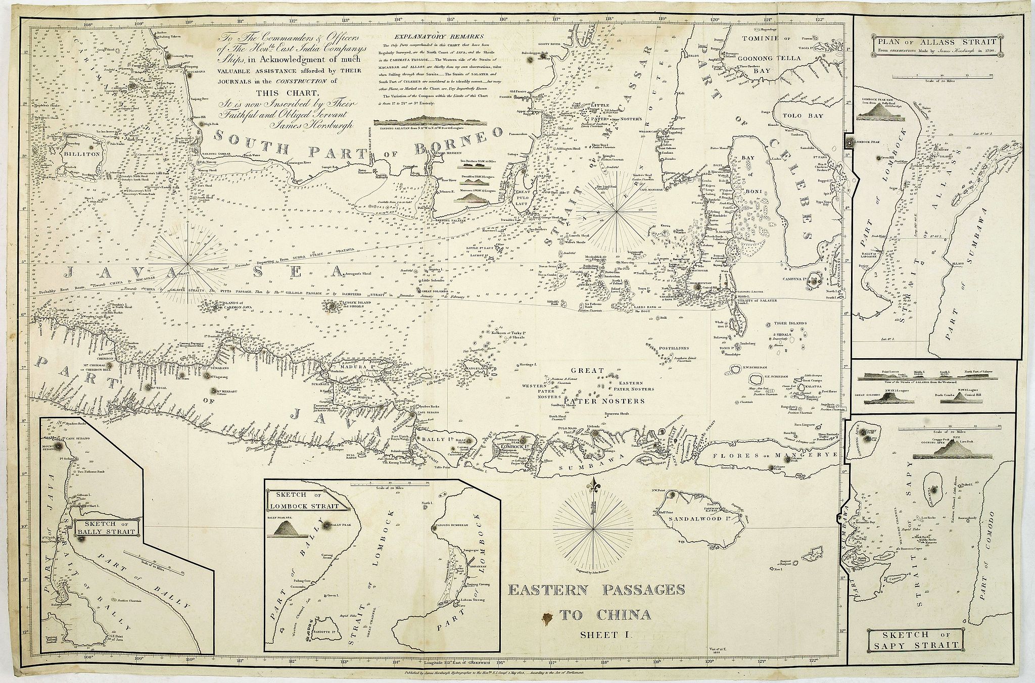
James Horsburgh early chart of the coasts of Java, Bali, Lombok, with part of Sulawesi, and Borneo. Insets of "Sketch of Bally Strait", Sketch of Lombock Strait", Plan of Allas Strait", "Sketch of Sappy Strait".
The chart shows depth soundings & both topographical and hydrographical details and proposed sailing directions in the Sunda Straits. Filled with several coastal profiles, which were of great help for the sailor.
In top Horsburgh thanks for the aid he has gotten for preparing this chart : "To the commanders and officers of the hon. East India Companys ships, in acknowledgment of much valuable assistance afforded by teir journals, in the construction of this chart, It is now inscribed by their faithful and obliged servant James Horsburgh".
As mentioned in his nine-lines EXPLANATION REMARKS, he mentions the areas which are well surveyed, as usual for that time the south coast of Java shows little information.
James Horsburgh was a distinguished hydrographer and was born at Elie, Fifeshire, September 23, 1762. At the age of sixteen, having acquired the elements of mathematical science, bookkeeping, and the theoretical parts of navigation, he sailed in various vessels, chiefly in the coal trade, from Newcastle and the Firth of Forth to Hamburg, Holland, and Ostend. In 1784 he bound for Bombay. In May 1786, when proceeding from Batavia towards Ceylon, he was wrecked upon the island of Diego Garcia, owing to the incorrectness of the charts then in use. On his return to Bombay, he joined, the Gunjava, and bound to China. On the vessel’s arrival at Canton, he became first mate, in which capacity he continued to sail, in that and other ships, between China, Bombay, and Calcutta, for several years.
Horsburgh’s experience and observation had enabled him to accumulate a vast store of nautical knowledge, bearing especially on eastern hydrography. During two voyages to China, by the eastern route, he constructed three charts, one of the Strait of Makassar, another of the west side of the Philippine Islands, and the third of the tract from Dampier Strait, through Pitt’s Passage, towards Batavia, accompanied by a Memoir of Sailing Directions, which were published under the patronage of the court of directors of the East India Company, for the use of their ships.
In 1805 Horsburgh returned to England, and soon after he published various charts. In 1810, on the death of Dalrymple, he was appointed hydrographer to the East India Company. In 1835 he published a Chart of the East Coast of China, having the names in the Chinese character and in English, translated by himself, which was his last work. He died May 14, 1836.

FAQ - Guarantee - Shipping
994 BuyBidBuying in the BuyNow Gallery
This item is available for immediate purchase when a "Add to Cart" or "Inquire Now" button is shown.
Payments are accepted in Euros or US Dollars. We accept most major credit cards, PayPal and bank transfer.
Authenticity Guarantee
 We provide professional descriptions, condition report and HiBCoR rating (based on 45 years experience in the map business)
We fully guarantee the authenticity of items we sell. We provide a certificate of authenticity for each purchased item.
Condition / Coloring
We indicate the condition of each item and use our unnique HiBCoR grading system in which four key items determine a map's value: Historical Importance, Beauty, Condition/Coloring and Rarity.
We offer many maps in their original black and white condition. We do not systematically color-up maps to make them more sellable to the general public or buyer.
Copper engraved or wood block maps are always hand colored. Maps were initially colored for aesthetic reasons and to improve readability. Nowadays, it is becoming a challenge to find maps in their original colors and are therefor more valuable.
We use the following color keys in our catalog:
Original colors; mean that the colors have been applied around the time the map was issued.
Colored; If the colors are applied recently or at the end of the 20th century, then "colored", or "attractive colors" will be used.
Original o/l colors; means the map has only the borders colored at the time of publication.
Read more about coloring of maps [+]
FAQ
Please have a look for more information about buying in the BuyNow gallery.
Many answers are likely to find in the general help section.
My Collection+
![]()
With My Collection+ you can collect all your favorite items in one place. It is free, and anyone can create his or her virtual map collection.
Unless you are logged in, the item is only saved for this session. You have to be registed and logged-in if you want to save this item permanently to My Collection+.
Read More [+]
If you want to save the items permanently, please sign in
or create account first. ![]()
Registering Here, it is and you do not need a credit card.
Add this item to
My Collection+
or click the following link to see My Collection+.
Invoice
The invoice and certificates of authenticity are available in the client center >Invoices
| Digital Image Download | |
|
Paulus Swaen maintains an archive of most of our high-resolution rare maps, prints, posters and medieval manuscript scans. We make them freely available for download and study. Read more about free image download |
Click the image for a free small image download. |
In accordance with the EU Consumer Rights Directive and habitually reside in the European Union you have the right to cancel the contract for the purchase of a lot, without giving any reason.
The cancellation period will expire 14 calendar days from the day after the date on which you or a third party (other than the carrier and indicated by you) acquires, physical possession of the lot. To exercise the right to cancel you must inform Paulus Swaen Inc, of your decision to cancel this contract by a clear statement (e.g. a letter sent by post, or e-mail (amsterdam@swaen.com).
To meet the cancellation deadline, it is sufficient for you to send your communication concerning your exercise of the right to cancel before the cancellation period has expired.
