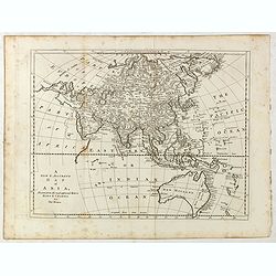
Browse Listings in Asia
![[65] Surie.](/uploads/cache/12837-250x250.jpg)
[65] Surie.
Charming chart of the harbour of the town of St Jean d'Acre in Syria. Showing town and harbour plan, with soundings, anchorages, rocks, shoals, fortifications and lightho...
- $120 / ≈ €105
Date: Marseille, 1764
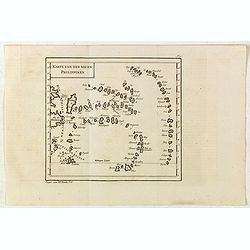
Karte von den neuen philippinen.
Small map of the southern Philippines. In: "Allgemeine Historie der Reisen zur Wasser und zu Lande: oder Sammlung aller Reisebeschreibungen.. in Englischen zusammen ...
- $200 / ≈ €175
Date: Leipzig, Arkstee und Merkus, 1764
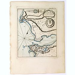
Plan de Maye a la Coste de Malabar.
From Bellin's "Le Petit Atlas Maritime", a plan of the bay of Maye, off the Malabar coast of southern India. Map relief shown pictorially. Shows settlements, po...
- $100 / ≈ €87
Date: Paris, 1764
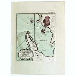
Baye Ville et Forts d'Andarajapour a la Coste de Malabar.
From Bellin's popular "La Petit Atlas Maritime", showing the bay, fort and town of Andarajapour in the Malabar region of India. The map is furnished with a comp...
- $110 / ≈ €96
Date: Paris, 1764
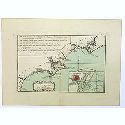
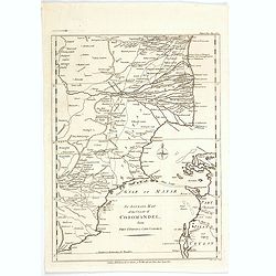
Coste de Coromandel depuis Gondagamas jusqu'a Narzapour.
This map is taken from Bellin'spopular 'Petit atlas maritime'. It shows a portion of the Indian coastline in the region of Coromandel from Montepdly through Mazulipatam o...
- $110 / ≈ €96
Date: Paris, 1764
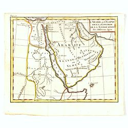
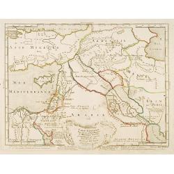
l'Arabie et l'Egypte pour la Concorde de la Géographie des different Ages.
Uncommon map of Arabian Peninsular with a title inland "Arabie Heureuse. . .".More about Mapping of Arabia [+]
Date: Paris, 1765
![Plan de Gingy, ville et forteresse d'Asie . . . [An Early Manuscript Map of Pondicherry Prior To Its Reconstruction After The Seven Years War.]](/uploads/cache/43006-250x250.jpg)
Plan de Gingy, ville et forteresse d'Asie . . . [An Early Manuscript Map of Pondicherry Prior To Its Reconstruction After The Seven Years War.]
An early manuscript map of Gingy shortly after The Seven Years War, when the French took possession of large part of India.With an extensive key to the left.Gingee Fort o...
- $1500 / ≈ €1310
Date: Paris, 1765
Carte de la Babylonie nommée aujourd'hui Hierac-Arab avec les noms, tant anciens que modernes et les routes des expéditions de Cyrus et de Julien l'Apostat, aussi bien que celles de Teixera, Benjamin. . .
A very fine map centered on Arabia and in top Iraq with Baghdad. With a very attractive title cartouche on the lower left-hand corner. Published by Joseph-Nicolas De l' I...
- $550 / ≈ €480
Date: Paris/ Bordeaux, 1766
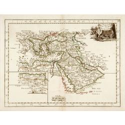
L'Empire des Turcs.
With decorative title cartouche upper right. Good detail in the Arabian peninsula.More about Mapping of Arabia [+]
Date: Paris, 1767
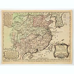
La Chine.
With decorative title cartouche lower right. Good detail of China's mainland with Taiwan and Hainan Province.
- $300 / ≈ €262
Date: Paris, 1767
De l'Asie. . .
On the left and on the right two explication cartouche. The text is in French, interesting for its documentation of contemporary European attitudes and preconceptions reg...
- $300 / ≈ €262
Date: Paris, ca. 1767
![Plans de Quelques Villes de la Province de Hou-Quang. / Grondtekening [floor plan] van eenige Steden van't Landschap Hu-Quang.](/uploads/cache/34078-250x250.jpg)
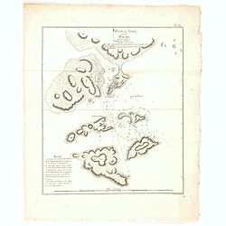
Plans de Quelques Villes de la Province de Hou-Quang. / Grondtekening [floor plan] van eenige Steden van't Landschap Hu-Quang.
Interesting set of three local town plans each with extensive titles :"Yong Chew Fu, ou Yong Tcheou Fou." Centre: "Vu Chang Fu, ou Vou-Tchang-Fou Capitale:...
Date: The Hague, Pieter de Hondt, 1747-1767
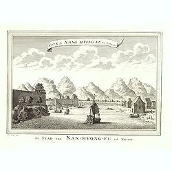
Cité de Nang Hyong Fu, tiree the Nieuhof. De Stad van Nan-Hyong-Fu, uit Nieuhof.
Interesting view of Nan-Hyong-Fu with harbour and fort.Prepared by Jacques Nicolas Bellin and included in a Dutch edition of Prévost d' Exile's "Histoire des Voyage...
Date: The Hague, Pieter de Hondt, 1747-1767
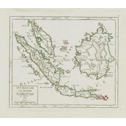
Les Isles de la Sonde.
Small detailed map of southeast Asia, showing the Malay Peninsula, Sumatra, Java and the island of Borneo. Dated 1769.From Atlas Portatif Universel, by Robert de Vaugondy...
- $200 / ≈ €175
Date: Paris, later than 1769
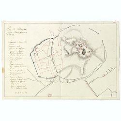
Plan de Thiagar, prise par l'arméé française en 1759.
An early manuscript map of Thiagar. With an extensive unfinished key to the left. The map was drawn shortly after the end of the Seven Years War, when the French took pos...
- $750 / ≈ €655
Date: Paris, 1769
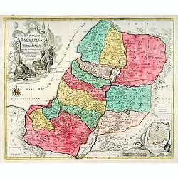
Terra Sancta sive Palaestina. . .
Map of Palestine divided among the Tribes on both sides of Jordan and into Kingdoms of Judah and Israel. Cartouche at bottom right features a small map of the Exodus.T.C....
- $750 / ≈ €655
Date: Augsbourg, 1770

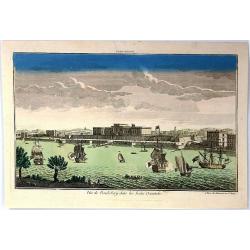
Vue des Promenades et les Fontaines d'Ispahan.
Carmine was a well-known publisher of optical prints, established in Augsburg.Isfahan was once one of Central Asia's largest and most important cities, at the crossroads ...
Date: Augsburg 1770
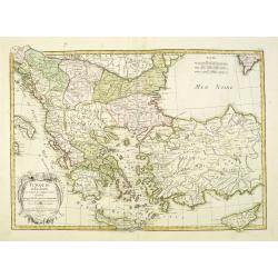
Turquie d'Europe et partie de celle d'Asie…
An attractive map of Turkey, Greece, Cyprus. Prepared by Janvier.
Date: Paris, 1771

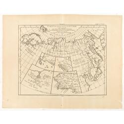
Carte des parties Nord et est de l'Asie.. (5 maps on one sheet)
Five maps on one sheet, showing California, Alaska and Syberia, Korea and Japan. South to Korea the island "Quelpaerts".The map is from Diderot's "Encyclop...
- $200 / ≈ €175
Date: Paris, 1772
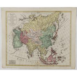
Asia secundum novas celeberrimi de l'Isle Projectiones aliorumque. . .
A pleasant map of the continent of Asia, with each country displayed in a different color. Plain oval title cartouche. A set of 5 different mileage scales lower left corn...
Date: Augsburg, 1772
Nouvelle Representation des Cotes Nord et Est de L'Asie. . .
Three overlaid maps on one sheet. This interesting map shows northern coast of Europe and Asia, focusing on the idea of a North East Passage. Japan and Korea are shown on...
Date: Paris, 1772
Carte des parties Nord et Est de L'Asie. . .
Five maps on one sheet, showing the Northern Russian territories in Europe and Asia, including the western coastline from Siberia, with Japan and Korea with the island of...
Date: Paris, 1772
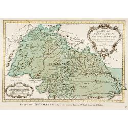
Carte de L'Indoustan. . .
Uncommon edition of this fine map of the northern part of India.From Atlas Portatif pour servir a l'intelligence de l'Histoire Philosophique et Politique des etablissemen...
- $150 / ≈ €131
Date: Amsterdam, 1773
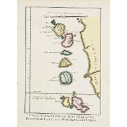
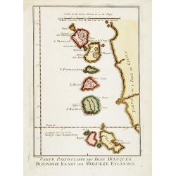
Carte Particuliere des Isles Moluques.
A very nice map centered on the island of the Moluccas.From Atlas Portatif pour servir a l'intelligence de l'Histoire Philosophique et Politique des etablissements et du ...
- $75 / ≈ €66
Date: Amsterdam, 1773
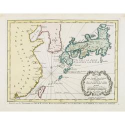
Carte des Isles du Japon.. Coree, Avec .. De la Chine..
Uncommon map of Japan, with Hokkaido, Ryukhu, Korea, Taiwan and the southeast coast of China from Peking till Macao.A mysterious "Corree" shows only a scant few...
Date: Amsterdam, 1773
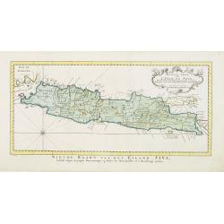
Nouvelle carte de l'Isle de Java.
A very nice map centered on the island of Java. With French text in title cartouche and an additional title in Dutch underneath the map.Read more Early maps of South East...
Date: Amsterdam, 1773
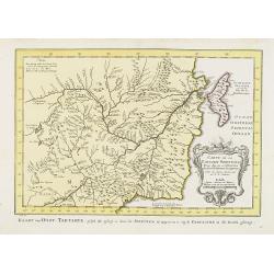
Carte de La Tartarie Orientale..
Uncommon edition of this fine map of Tartary with the Island of Sakhalin. In lower right engraved 21b.From Atlas Portatif pour servir a l'intelligence de l'Histoire Philo...
Date: Amsterdam, 1773
Carte Particuliere des Isles Moluques. . .
A very nice map centered on the island of the Moluccas.Title in French and in Dutch underneath the map.
Date: Amsterdam, 1773
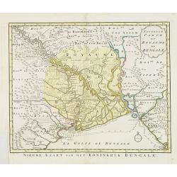
Nouvelle carte du Royaume de Bengale.
Uncommon issue of this detailed map of Bangladesh with the Ganges delta, including Calcutta. Giving great detail with trade routes, European trade settlements, etc. Prepa...
- $380 / ≈ €332
Date: Amsterdam, 1773
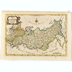
The Russian Empire, from the Best Authorities, by Thos. Kitchin, Geographer.
Showing the Asian part of Russia, with interesting note to a coast line north of Siberia "Land seen in 1723", likely referring to Vitus Bering (1681–1741), wh...
- $150 / ≈ €131
Date: London, c. 1773
L'Empire de La Chine../ 't Keizerryk van China..
An attractive map of China with Korea and Taiwan (I.Tay-wan, ou Formosa) and "Mer de Coree'. There are decorative title cartouches in three corners of the map. The u...
- $200 / ≈ €175
Date: The Hague, 1773
Carte Plate de la partie Septentrionale du Detroit de Malac, depuis de la rade d'Achem jusqu'a Malac.
French chart of the Island of Sumatra and the Malay Peninsula separated by the strait of Malacca in Indonesia.Latitude and longitude scales, compass rose and system of rh...
Date: Paris, ca. 1775

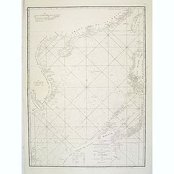
Carte réduite de l'Océan Oriental, depuis Le Cap de Bonne Espérance jusqu'à l'Isle Formose.
French chart covering the seas between the Cape of Good Hope and Taiwan and the West Coast of Australia. Prepared by Jacques-François L'Abbé Dicquemare (1733-1789). Lat...
Date: Paris, Brest, chez Demonville, 1775
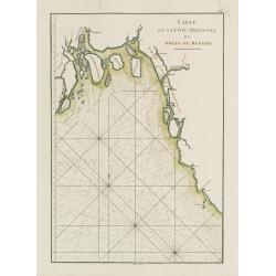
Carte de l'Entrée du Golf de la Mer Rouge. / Plan de La Rade de Moka.
French sea chart of the entry of the Red Sea showing both the African and Arabian coasts. With two inset charts: Plan de La Rade de Moka. and one with the coasts south of...
Date: Paris, ca 1775

Carte de la Côte de Guzerat, Du Golf de Cambaye et des Côtes de Concan et De Canara.
French sea chart of West India from Gujarat to Mangalore. With inset chart Plan de la Rivière de Surate.Prepared by Jacques-François L'Abbé Dicquemare (1733-1789). La...
Date: Paris, ca 1775
Carte de la Côte Orientale du Golfe du Bengale.
French sea chart of coast northeast of India. Latitude and longitude scales, compass rose and system of rhumb lines, soundings near coast and in bay areas.D' Après de Ma...
- $150 / ≈ €131
Date: Paris, ca 1775
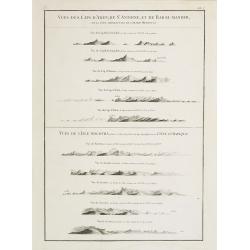
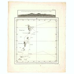
Vues des Cap d'Aden, de St. Antoine, et de Bab-El-Mandeb, sur la Côte Méridionale de l'Arabie Heureuse. Vues de l'Isle de Socotra
Coast profiles near Cape Aden in Yemen and in the lower part coastal profiles near Socotra, an island east of the Horn of Africa and 380 kilometers (240 mi) south of the ...
- $250 / ≈ €218
Date: Paris, Brest, chez Demonville, 1775
Carte Plate qui comprend La partie septentrionale de LA Cöte de Coromandel et les Côtes de Golconde , D' Orcha et de Bengale.
French chart of Coromandel in India. West to the top.Latitude and longitude scales, compass rose and system of rhumb lines, soundings near coast and in bay areas.D' Aprè...
- $150 / ≈ €131
Date: Paris, Brest, chez Demonville, 1775

Carte de la Baye et du Port de Trinquemalay dans L'Isle de Ceylan.
Chart showing the bay of Trincomalee, Ceylon (Sri Lanka). Trincomalee is natural deep water port on the east coast of Sri Lanka, about 110 miles northeast of Kandy. It is...
- $250 / ≈ €218
Date: Paris, 1775
Carte de la Mer Rouge, depuis Moka jusqu'a Gedda.
Chart of the Red Sea. With 3 inset maps of Shake Omare, Goofs and Gedan.D'Après De Mannevillette (1707-1780) was one of France's first hydrographers. When the first edit...
- $450 / ≈ €393
Date: Paris, 1775
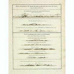
Vues diverses du fort de l'Agouade pres de l'isle de Goa . . . Sumatra . . .
French sea sea chart with 9 coastal views near Goa in India and Sumatra. The titles above the main profiles reading as following : Vues diverses du fort de l'Agouade pre...
- $200 / ≈ €175
Date: Paris, Brest, Demonville, 1775
A chart of the China Sea inscribed to Monsr. D'APRES de MANNEVILLETTE .. To A.Dalrymple.
Most important milestone sea chart is based upon the surveys made from navigational surveys by Alexander Dalrymple (1737-1808]. He was the first Hydrographer of the Briti...
Date: Paris, ca. 1775
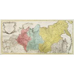
Carte de la sibérie et des Pays voisins.
An interesting detailed map of Siberia, extending from the White Sea and the Caspian Sea in the west to Irkuckoi Province .Prepared by Jacques Nicolas Bellin after Dutch ...
Date: Paris, 1738-1775
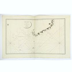
Carte des Isles Kouriles, d'après la carte Russe dréssée et gravée par Laurent.
An interesting map of the Kuril Islands, northeast from Hokkaido, Japan, to Kamchatka, Russia, separating the Sea of Okhotsk from the North Pacific Ocean.Prepared by Jacq...
Date: Paris, 1738-1775
Suite de la carte de La Sibérie et le pays de Kamtschatka...
An interesting map of Siberia, with a view on Ochozk Sea. Prepared by Jacques Nicolas Bellin after Dutch sources and included in Prévost d' Exile's "Histoire des Vo...
- $75 / ≈ €66
Date: Paris, 1738-1775
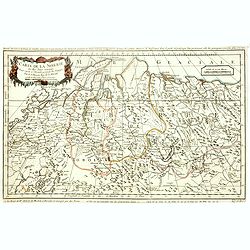
Carte de la sibérie et des Pays voisins.
An interesting detailed map of Siberia, extending from the White Sea and the Caspian Sea in the west to Irkuckoi Province .Prepared by Jacques Nicolas Bellin after Dutch ...
- $50 / ≈ €44
Date: Paris, 1738-1775

Carte de la Baye et du Port de Trinquemalay Dans L'Isle de Ceylan.
French chart of the harbor of Trinquemalay on the island of Ceylon. Prepared after Samuel Cornish who was a vice admiral for the English East India company.Latitude and l...
- $350 / ≈ €306
Date: Paris, Brest, chez Demonville, 1775
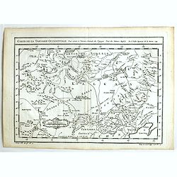
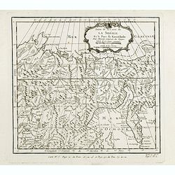
Carte de la Tartarie Occidentale.
An interesting map of Tartary and northeast Asia, from Lake Baykal, Partie du Siberia in the north, Pays des Kalkas at the center, as well as Desert de Sable, and down to...
- $95 / ≈ €83
Date: Paris, ca. 1775
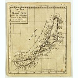
Neue Carte des Baikal Sees welche bey Umschiffung desselben in den Iahren 1773 und 1773 aufgenommen worden.
Rare engraved map by Johanna Dorothea Sysang, showing Lake Baikal. Johanna Dorothea Sysang (1729 - 1791) was a copper engraver from and was a daughter of Johann Christoph...
Date: 1777
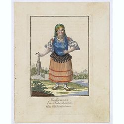
Une Kabardinienne.
Uncommon copper engraved costume plate from the French translation of Johann Gottlieb Georgi "Beschreibung aller Nationen des Russischen Reichs" (1776), the wor...
Date: St. Petersbourg, C.G. Müller, 1776-1777

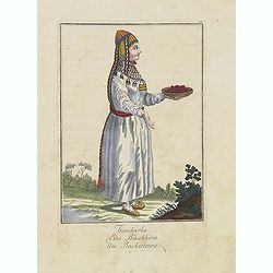
Femme Barabinzoise.
Uncommon copper engraved costume plate from the French translation of Johann Gottlieb Georgi "Beschreibung aller Nationen des Russischen Reichs" (1776), the wor...
Date: St. Petersbourg, C.G. Müller, 1776-1777

Fille Barabinzoise.
Uncommon copper engraved costume plate from the French translation of Johann Gottlieb Georgi "Beschreibung aller Nationen des Russischen Reichs" (1776), the wor...
Date: St. Petersbourg, C.G. Müller, 1776-1777
Une Baskirienne.
Uncommon copper engraved costume plate from the French translation of Johann Gottlieb Georgi "Beschreibung aller Nationen des Russischen Reichs" (1776), the wor...
Date: St. Petersbourg, C.G. Müller, 1776-1777
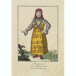
Une Metcherèke.
Uncommon copper engraved costume plate from the French translation of Johann Gottlieb Georgi "Beschreibung aller Nationen des russischen Reichs" (1776), the wor...
Date: St. Petersbourg, C.G. Müller, 1776-1777
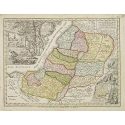
Terra Sancta vocata quae olim XII tribus . . .
Miniature map of the Holy Land, among the 12 Tribes and divided into 6 provinces. In the upper left near the title cartouche Pharaoh''s daughter discovers Moses in the Ri...
- $300 / ≈ €262
Date: Augsburg, J.M.Will, 1778
A new and accurate map of Asia, Drawn from the most approved modern maps & charts / by Thos. Bowen.
The map is of interest for the use of Sea of Korea for the sea between Korea and Japan.Detailed map of Asia from Saudi Arabia, Persia, Russia, India, China, Japan to Sout...
Date: London, J.Cooke, 1777-1778
Magni Turcarum dominatoris Imperium . . .
Uncommon version of this small map of the Ottoman Empire extending from the Balkans and the north African coast through Arabia the Black Sea. Decorated with a small compa...
Date: Augsburg, J.M.Will, 1778
China.
A nice mid-eighteenth-century map of China, extending from the island of Hainan in the south, to the Kobi Desert in the north, from Lake Puka in Tibet in the west to Kore...
- $150 / ≈ €131
Date: Edinburgh, 1778
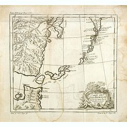
![The country Coromandel from the Coleroon to Cape Comorin. . . [with] The carnatic from the Pennar to the Coleroon. .](/uploads/cache/48363-250x250.jpg)
The country Coromandel from the Coleroon to Cape Comorin. . . [with] The carnatic from the Pennar to the Coleroon. .
Coromandel from the Coleroon to Cape Comorin. Elegant map in two sheets compiled for the East-India Company. In lower right margin : Writing by W. Harrison.
- $300 / ≈ €262
Date: London, 1778
Carte géographique contenant le royaume de Sibérie . . .
Scarce and highly detailed map of Siberia subdivided into three provinces, namely Tobolsk, Jenissejesk, Irkutsk, and outer parts of the Tartary.In upper right corner inse...
Date: Augsburg, c. 1770-1780
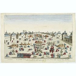
Ceremonie de la grande Feste que les Chinois celebre le 24 de la Lune d'Aoust dans la principale Place de Pekin.
So-called optical print illustrating the festivities on the 24th of August in Beijing.Mondhare was a well-known publisher of optical prints, established in Paris, at rue ...
Date: Paris, c.1780
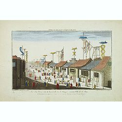
Vue perspective de la grande Rue de Nanquin ancienne Ville de la Chine.
So-called optical print of a street in Nanking. The wide boulevard is lined with merchants displaying their wares with colorful flags and signs. The street is filled with...
Date: Paris, c.1780
Carte géographique contenant le Royaume de Siberie . . .
Very rare and highly detailed map of Siberia subdivided in three provinces, namely Tobolsk, Jenissejesk, Irkutsk, and outer parts of the Tartary. In upper right corner in...
- $800 / ≈ €699
Date: Augsburg, 1770- 1780
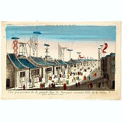
Vue perspective de la grande Rue de Nanquin ancienne Ville de la Chine.
So-called optical print of a street in Nanking. The wide boulevard is lined with merchants displaying their wares with colorful flags and signs. The street is filled with...
Date: Paris, c.1780
![Une Chamane ou devineresse de Krasnojarsk par derrière.[together with] Une Chamane ou devineresse de Krasnojarsk.](/uploads/cache/33007-250x250.jpg)
Une Chamane ou devineresse de Krasnojarsk par derrière.[together with] Une Chamane ou devineresse de Krasnojarsk.
Uncommon copper engraved costume plate from Johann Gottlieb Georgi "Beschreibung aller Nationen des russischen Reichs" (1776), the work stands out for the hand-...
- $100 / ≈ €87
Date: St. Petersbourg, C.G. Müller, 1776-1780
Vue de la Pondichery dans les Indes Orientales
Pondicherry is the capital city of Indian union territory of Puducherry. Pondicherry is situated in Puducherry district of the union territory in India. The vue was produ...
Date: Paris, 1780
Turchia Nell' Asia antica, e moderna.
Rare map of Armenia, Palestine, Turkey and northern Arabia, from "Atlante Novissimo ad uso Dei Giovani Studiosi Contenuto In Carte XXVII.", published by Giovann...
- $200 / ≈ €175
Date: Rome, 1780
La China e Giapone.
Rare map of China, Korea and Japan, from "Atlante Novissimo ad uso Dei Giovani Studiosi Contenuto In Carte XXVII.", published by Giovanni Zempel in Rome, ca. 17...
- $300 / ≈ €262
Date: Rome, 1780
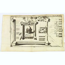
Madirass. Ville Indienne don't les Maisons sont basses & plates.
A small plan of Fort St. George, Madras/Chennai in India. It highlights both inner and outer fortifications, fences, town entrances and the sea, together with the church,...
Date: Unknown, ca 1780
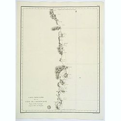
Carte Generale des Cotes de la Cochinchine et du Camboge.
A large, double-page French sea chart of part of the southern Cambodian coastline, and from Vietnamese Saigon up to Vung-Tau, Cap Varella, Cam Ranh Bay and Nha Trang. Wit...
Date: Paris, 1780
Carte Particuliere de la Cote de Cochinchine Depuis la baie Camraigne jusqu'a le baie de Tamquam.
A basic coastal sea chart of a part of French Indochina (Vietnam) from Cap Varella and Cam Ranh Bay in the south, northward past Nha Trang, Hen Kohe Bay, on to Phu-yen Ba...
Date: Paris ca 1780
Plan du Typa, ou de Macao.
A pleasant copper engraving of Typa, Macao. By Rigobert Bonne from his ATLAS ENCYCLOPEDIQUE published in 1780. Engraved by Andre.Rigobert Bonne (1727-1795) was one of the...
- $100 / ≈ €87
Date: Paris, 1780
Vue de la Côte du Japon lorsque nous la vimespour la 1ere fois La Coline A restant dans l'O à 3 Millerc.
A pleasant copper engraving of Japan coasts. By Rigobert Bonne from his ATLAS ENCYCLOPEDIQUE published in 1780. Engraved by Andre.Rigobert Bonne (1727-1795) was one of th...
- $100 / ≈ €87
Date: Paris, 1780
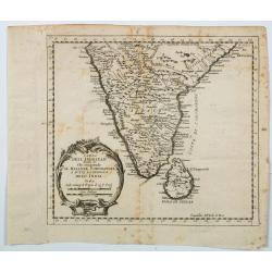
Carta Dell' Indostan che comprende il Malabar, Coromandel, e tutta la penisola Dell' India.
This is from a scarce Italian edition of French cartographer Jacques-Nicholas Bellin’s map of southern India and the island of Ceylon (Sri Lanka). The map extent is fro...
Date: Paris, ca 1780
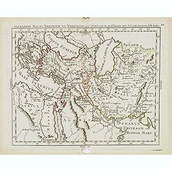
Alexandri magni imperium et expeditio per Africam. . .
Scarce map of the Imperium of Alexander the Great, centered on Turkey, Armenia, Uzbekistan, etc., prepared by Nolin and published by L.J. Mondhare for his Atlas Généra...
Date: Paris, 1781
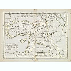
Carte de la retraite des dix mille. . .
Ancient map of Near and Middle East, including Cyprus, prepared by Nolin and published by L.J. Mondhare for his Atlas Général a l'usage des colleges et maisons d'educat...
- $50 / ≈ €44
Date: Paris, 1781
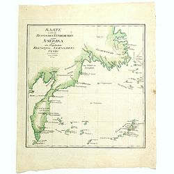
Karte welche die Russischen Entdeckungen gegen Amerika nach den Tagebüchern Krenizins, Lewaschefs, Synds und anderer vorstellt. 1781
Rare map of Siberia with Kamchatka. In outer right tip of America, published by the Weygandsche Buchhandlung in 1781.
- $300 / ≈ €262
Date: Leipzig, 1781
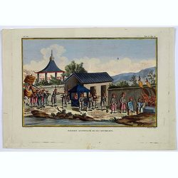
Mandarin accompagne de ses Bourreaux.
A copperplate taken from volume 2 of the work by Sonnerat titled: 'Voyage aux Indies Orientales et a Chine, fait par ordre du Roi, depuis 1774-1781…'.This colored coppe...
- $125 / ≈ €109
Date: Paris, ca. 1782
An Accurate Map of the Coast of Coromandel, from Fort St. David to Cape Comorin.
This is a finely engraved map of the south eastern Indian Coromandel coastal regions & the north west Sri Lankan coast through the Gulf of Manar. It was engraved by J...
Date: London, 1782
Carte générale pour servir à l'Intelligence de..
Fine map of the Middle East, including the Holy Land, Cyprus, Iran and Irak, etc.Philippe Buache was one of the most active proponents of the so-called, "school of t...
- $300 / ≈ €262
Date: Paris, 1783
