Browse Listings

Het Friessche Doolhoff, het beruchte dorp Molk-Worren
Uncommon map made in 1718 by Johannes Hilarides, principal at the Latin School in Bolsward.. Probably the only printed plan of a Frisian village of that time. The map was...
Date: Amsterdam, 1705

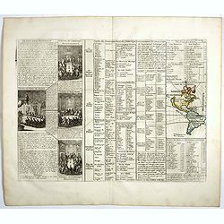
Description de l'Isle Formosa en Asie, du gouvernement, des
Complete title: Description de l'Isle Formosa en Asie, du gouvernement, des Moers & de la religion des habitans.Rare first French edition of one of the most famous fi...
Date: Amsterdam, 1705
Estats du Grand Duc de Moscovie.
Lovely small map of' Russia in Europe', extending from Poland and the Baltic in the west, Zembla in the frozen north, reaching down south to the Ukraine with Kiev and par...
- $150 / ≈ €127
Date: Paris, 1705
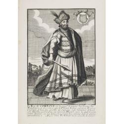
Le Roy de Camboia est le Seig.r de touts les Costes de Malabares, et des terres que le Fleuve Indus. . .
Very rare and decorative costume plate. Underneath the plate a descriptive text in French.Bears the address : A Paris chez F. Jollain l aine Rue St Jacques a la Ville de ...
- $200 / ≈ €170
Date: Paris, ca. 1685-1705
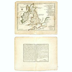
Les Isles Britanniques ou sont les Royaumes . . .
An interesting small map of the British islands by Nicolas de Fer. From his rare "Petit et Nouveau Atlas". The first edition was published in 1697 and was repub...
Date: Paris, 1705
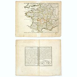
La France avec ses acquisitions jusqu'à l'année 1705.
An interesting small map of France by Nicolas de Fer. From his rare "Petit et Nouveau Atlas". The first edition was published in 1697 and was republished in 170...
Date: Paris, 1705
![Le Cours du Danube. . .[2 maps].](/uploads/cache/28472-250x250.jpg)
Le Cours du Danube. . .[2 maps].
Detailed two-sheet map of the course of the River Danube from its source up to Vienna. Showing the cities, like Linz, Passau, Straubing, Regensburg, Ulm, Augsburg, Munich...
- $450 / ≈ €382
Date: Paris, 1705
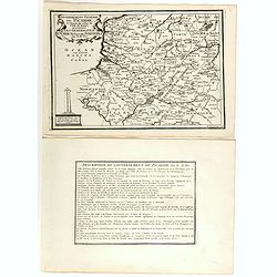
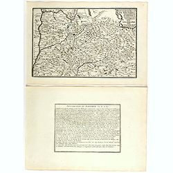
Gouvernement general de Picardie . . .
Map of the Picardie region, from Nicolas de Fer's "L'Atlas curieux ou le Monde réprésente dans des cartes. "The "Atlas Curieux" is a geographic ency...
Date: Paris, 1705
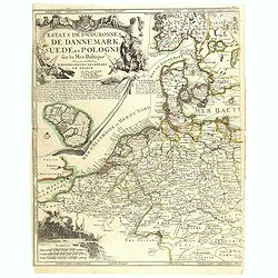
Estats..de Dannemark, Suede, et Pologne..
Rare map of Poland, Denmark, Sweden, The Netherlands, Belgium and Germany. Engraved by H.van Loon. Upper left hand corner fine title cartouche and inset map of the island...
- $400 / ≈ €339
Date: Paris, 1705
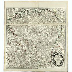
Carte du Brabant.
Map of Brabant with the address : Chez l’Auteur sur le Quai de l’Horloge (address erased after Horloge). Avec privilege du Roy. 1705." Guillaume de l'Isle's (167...
Date: Paris, 1705
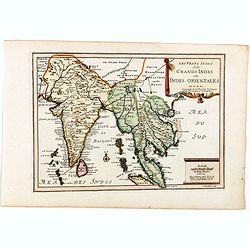
Les Vrays Indes dits Grands Indes ou Indes Orientales Par N. de Fer. Geographe de Sa Majeste Catoliques et de Monseigneur le Dauphin.
Detailed map on India, Thailand, the Malay Peninsular and the south coast of China up to Macao. The map was engraved by C. Inselin.
Date: Paris, 1705
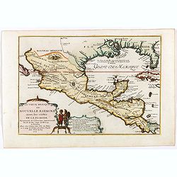
Le vieux Mexique ou nouvelle Espagne. . .
Attractive map covering the Gulf of Mexico through Central America also including parts of Cuba and Jamaica. It extends through Mexico to show the southern tip of Baja Ca...
Date: Paris, 1705

Horizon ring for globe.
Printed horizon ring for a 28cm diameter German globe. The ring is divided in quarters and engraved two by two on one copper plate. The size of the paper is 44 x 33cm. Th...
Date: Nuremberg, 1704/1705
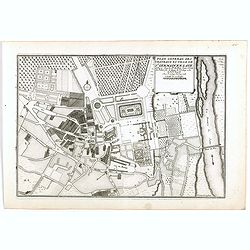
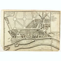
Plan general des chateaux et ville de St Germain en Laye.
City plan of St Germain en Laye, from Nicolas de Fer's "L'Atlas curieux ou le Monde réprésente dans des cartes. "The "Atlas Curieux" is a geographic...
Date: Paris, 1705
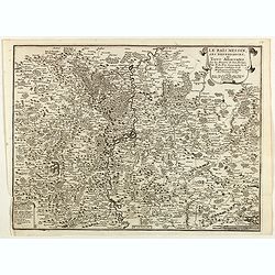
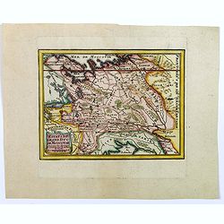
Le Païs Messin, ses dependances, et Terre Adiacentes.
Map of the Messin region, from Nicolas de Fer's "L'Atlas curieux ou le Monde réprésente dans des cartes. "The "Atlas Curieux" is a geographic encycl...
Date: Paris, 1705
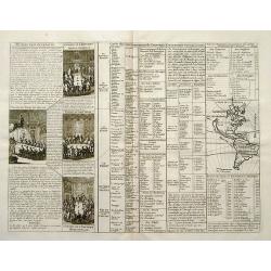
Carte du gouvernement de l'Amerique.
A double page sheet including a fine map of America, with California with indented northern coastline (130x92mm.) and New Mexico extending across most of western North Am...
- $300 / ≈ €254
Date: Amsterdam, 1705
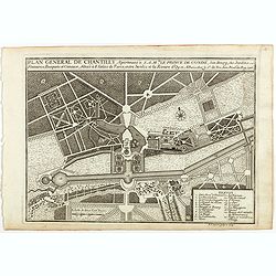
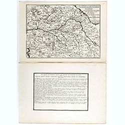
Plan general de Chantilly . . .
Plan of the city of Chantilly, from Nicolas de Fer's "L'Atlas curieux ou le Monde réprésente dans des cartes. "The "Atlas Curieux" is a geographic e...
Date: Paris, 1705
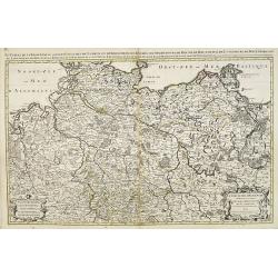
Le cercle de la Basse Saxe subdivisé en touts les estats et principautés qui le composant . . .
It is a very large map centered on the river Elbe and following the coastlines of the Baltic Sea up to the Polish border. The map is fully and richly engraved. Large and ...
- $200 / ≈ €170
Date: Amsterdam, c.1705
Plan de la belle et magnifique Maison de Monsieur A St Cloud . . .
Plan of the city of Saint Cloud, from Nicolas de Fer's "L'Atlas curieux ou le Monde réprésente dans des cartes. "The "Atlas Curieux" is a geographic...
Date: Paris, 1705
Gouvernement general de Languedoc . . .
Map of the Languedoc region, from Nicolas de Fer's "L'Atlas curieux ou le Monde réprésente dans des cartes. "The "Atlas Curieux" is a geographic enc...
Date: Paris, 1705

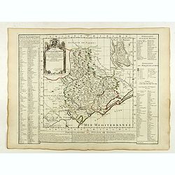
La mer Mediterranee divisee en ses principales parties ou mers. . .
Very large map centered on the Mediterranean. With a sub title along upper margin "La Mer Mediterranée divisée en Mer de Levant et de Ponant Subdivisées en Leurs ...
Date: Amsterdam, c.1705
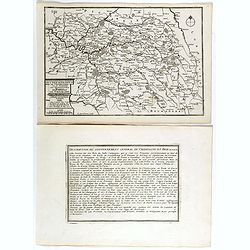
Les Gouvernements generaux de l'Isle de France et de Champagne, ou se trouvent les generalitez de Paris et Chaalons.
Map of the Isle de France and Champagne regions, from Nicolas de Fer's "L'Atlas curieux ou le Monde réprésente dans des cartes. "The "Atlas Curieux"...
Date: Paris, 1705
Carte du gouvernement de l'Amerique.
A double page sheet including a fine map of America, with California with indented northern coastline (130x92mm.) and New Mexico extending across most of western North Am...
- $300 / ≈ €254
Date: Amsterdam, 1705
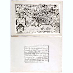
Souveraineté de Neuchatel et de Vallangin.
Map of the Neuchatel region, from Nicolas de Fer's "L'Atlas curieux ou le Monde réprésente dans des cartes. "The "Atlas Curieux" is a geographic enc...
Date: Paris, 1705
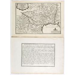
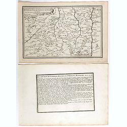
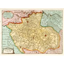
Les Provinces, ou Gouvernement de Poictou, d'Anjou, du Maine, De Touraine . . .
Map centered on Loire region, with Blois, Saumur, Sancerre and Orleans, from Nicolas de Fer's "L'Atlas curieux ou le Monde réprésente dans des cartes. "The &q...
Date: Paris, 1705
Gouvernement de Dauphiné, Generalité de Grenoble.
Map of the Dauphiné region, from Nicolas de Fer's "L'Atlas curieux ou le Monde réprésente dans des cartes. "The "Atlas Curieux" is a geographic enc...
Date: Paris, 1705

La Place de Saint Marc a Venise.
A very attractive Town plan of the place St Marc in Venice.Joan Blaeu published during his life three town books of Italy: Citta del Vaticano, Rome, and Napoli. By the ye...
Date: Amsterdam, 1705
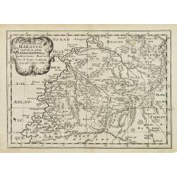
'T Koninkryk van Marocco, verdeelt in Zeven Landschappen, enz. . .
A Dutch edition of this finely engraved map of Morocco filled with mountain ranges, oases and cities. The map is adorned with a decorative cartouche.
- $90 / ≈ €76
Date: Amsterdam, ca. 1705
Gouvernement general du Lionnois, generalitez de Lion et de Riom . . .
Map of central France with Clermont-Ferrand and Lyon to the right, from Nicolas de Fer's "L'Atlas curieux ou le Monde réprésente dans des cartes. "The "A...
Date: Paris, 1705
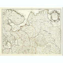
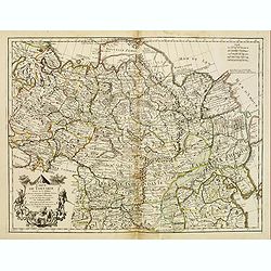
Carte de Moscovie dresseé par G.De L'Isle. . .
Detailed map of Russia centered on Moscow, including Lapland, prepared by de L'Isle and published in Amsterdam. With fine uncolored title cartouche.
- $375 / ≈ €318
Date: Paris, 1706

LA RUSSIE ROUGE ou POLONOISE qui Comprend les PROVINCES DE LA RUSSIE ROUGE de VOLHYNIE et de PODOLIE divisées en leurs Palatinats Vulgairement Connües sous le Nom D'VKRAINE ou PAYS DES COSAQUES.
A very rare Sanson map of Ukraine and so-called Russie Rouge, stretching from Lublin in the west to Kherson Oblast in the east (here called "Confin de La Petite Tart...
Date: Paris, 1706
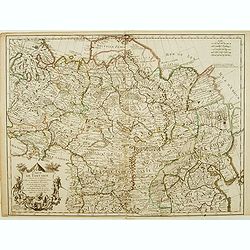
Carte de Tartarie..
Uncommon Amsterdam edition covering north east Asia, Korea and part of "Terre d'Eso". Nova Zembla joined with the mainland. Showing the Caspian Sea with presen...
Date: Amsterdam, 1706
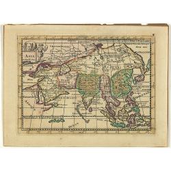
Asia.
Uncommon map of Asia, with a curious shape for Korea. Nice title cartouche in upper left corner with an elephant and a warrior. From his atlas Oorlogs tablessen, Oft uytg...
- $300 / ≈ €254
Date: Amsterdam, 1706
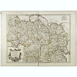
Carte de Tartarie.
Covering north east Asia, Tibet, Korea and part of "Terre d'Eso". Nova Zembla joined with the mainland.With good detail in Korea, several cities a labeled: Ch...
- $500 / ≈ €424
Date: Paris, 1706
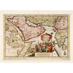
Zee-Togt van den Grooten Turk Uyt het Roode Meyr Tegen de Portugy fen na Indien tot aan Kaap Comorin Ondernomen.
Map of the Arabian peninsula, with Saudi Arabia, the Indian Ocean and India and Ceylon.Although not renowned for the originality of his work, Pieter van der Aa is highly ...
- $450 / ≈ €382
Date: Leiden, 1706
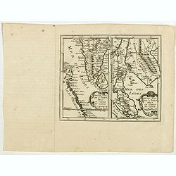
Prequ Isle de L'Inde deca Le Golfe du Gange (and) Prequ Isle de l'Inde dela le Golfe du Gange.
A very rare double map of India, Sri Lanka and the Maldives islands, together with a separate map of Cambodia, Thailand, Malaysia and North Sumatra. The map shows Bangkok...
Date: Brussels, Antwerp, 1706
Carte de Tartarie.
Rare first edition "Chez l'Auteur Rue des Canettes préz de St. Sulpice". The "Rue des Canettes" address appears on the original versions of maps date...
Date: Paris, 1706
La Mayerie de BOLDVC,. . .
From his atlas Oorlogs tablessen, Oft uytgesochte Kaarten . Covering the so-called area Meierij van 's-Hertogenbosch . Eindhoven in the centre of the map.
Date: Amsterdam, 1706
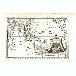
Reys-togt Thomas Coryat van Jerusalem te Land gedaan na Asmere de Hof-Stadt des Grooten Mogols in Oostindien.
The regional map illustrates the narrative of Thomas Coryat's travels by land from Jerusalem to the Court of the Great Mogul. Coryat travelled to Ajmer in India to the co...
- $450 / ≈ €382
Date: Leiden, 1706
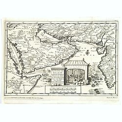
De Land-Reyse, door Benedictus Goes, van Lahor gedaan, door Tartaryen na China.
Interesting map showing the region of northeastern India, Nepal, Bhutan, Assam and Bangladesh. Canton in lower right corner.The map illustrates the narrative of the trave...
- $200 / ≈ €170
Date: Leiden, 1707
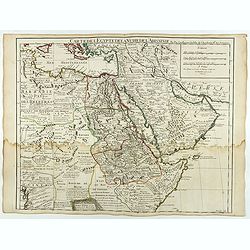
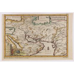
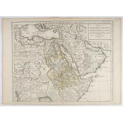
Carte de L'Egypte de la Nubie de L'Abissinie..
Including the Arabian Peninsula. Giving good detail on Egypt. Engraved by Desrosiers. Address and date changed, now with the imprint "A Paris Chez l’Auteur sur le ...
Date: Paris, November 1707

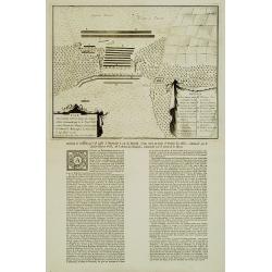
Carro, che uà à vela Su le Piagge di Schevelingue.
Italian version of Prince Maurits' sailing carriage designed by Simon Stevin. The big sailing-carriage could seat 28 persons and could reach a speed of seven miles per ho...
Date: Venice, 1707
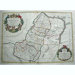
IUDAEA seu PALAESTINA... TERRA SANCTA... IUDA et ISRAEL
Map of Palestine divided among the Tribes, drawn by Homann after Guillaume Sanson. The shoreline runs from Sidon as far as Rinocorura. The Kishon River is shown as connec...
- $500 / ≈ €424
Date: Nuremberg, 1707
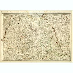
Partie Méridionale de l'Archevesché et Eslectorat de Cologne. . .
Fine map of the Westphalia, the area in-between the Rivers Maas and Rhine.
- $50 / ≈ €42
Date: Paris, 1707
De kusten van Arabie het Roode Meer en Persize Zee..
Map of the Arabian Peninsula till West Coast of India, southern Persia and the 'Horn of Africa'. Although not renowned for the originality of his work, Pieter van der Aa ...
Date: Leiden, 1707
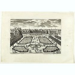
Le Parterre du Palais Royal.
View of the Palais Royal published by I. Mariette. Etched by Gabriel Pérelle (1603-1677) and included in "Veues des plus beaux bastimens de France". Plates for...
- $200 / ≈ €170
Date: Paris, 1700 - 1707
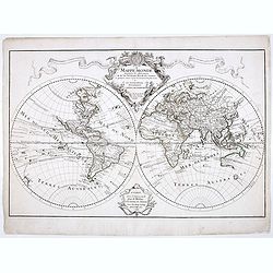
Mappe-Monde dressée sur les observations de M.rs. De L'Academie Royale des Sciences ..
Scarce and early state of the world map published c. 1707, by Delisles with the imprint "Chez l’Auteur sur le Quai de l’Horloge a la Couronne de Diamans, 1700&qu...
Date: Paris, 1707
Indien onder den Heer Lopo Vaz De Sampayo, als Gouverneur Generaal tot aan Nieuw-Spanje in American on Kusten van Peru en Chili bevaaren.
Most decorative and scarce item, centred on Indonesia, including an incomplete coast of Australia, and west coast of America. The South Pacific is occupied by a large tit...
Date: Leiden, 1707
D'Indize kusten van Bengale, Pegu, Malacca en Siam Tot in China. . .
Map of Indonesia, Malacca with Singapore (Cingapura) and Taiwan in upper right corner. In lower left a fine title cartouche showing Duarte de Menezes.Although not renowne...
Date: Leiden, 1707
Carte de L'Egypte de la Nubiede L'Abissinie. . .
Including the Arabian Peninsula. Giving good detail on Egypt. Engraved by Desrosiers.More about Mapping of Arabia [+]
- $300 / ≈ €254
Date: Paris, 1707
Carte du Diocese de Beziers . . .
Fine map of the diocese of Béziers with the address : A Paris Chez l’Auteur sur le Quai de l’Horloge a l’Aigle d’Or, avec Privil. Pr . 20 ans Mai 1708.In early 1...
Date: Paris, 1708
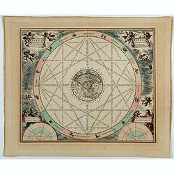
Typus aspectuum, oppositionum et conjunctionum…
A celestial chart with a circular projection map of the earth, centered in the North Pole, concentrates upon the planets' opposition and conjunction. With two diagrams in...
Date: Amsterdam, 1708
Plan De l'Action.. Auprès de Wynendale le 28 Sept. 1708.
A rare broadside sheet represents a conventional battle plan near the town of Torhout with the Castle Wynendale. The plan depicts the situation of 28 September 1708. Incl...
Date: Bruxelles, c.1708
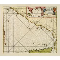
Paskaart der Zeekusten van Italien Tusschen Piombino en C. dell Arme Met de Noord-kust van 't Eylandt Sicilia..
Centered off the Ponziane Islands, this sea chart covers the area of the Tyrrhenian Sea, delimited by Sardinia, the Elba island, the Strait of Messina and Trapani. It con...
- $1000 / ≈ €848
Date: Amsterdam, 1708
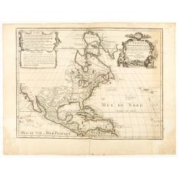
L'AMERIQUE SEPTENTRIONALE Dressée sur les Observations de Mr
One of the most influential maps of North America, laying the groundwork for much of the cartography of the 18th century. This is an early re-issue of De l'Isle's landmar...
Date: Paris, 1700 -1708
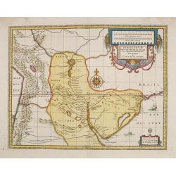
Paraguay o Prov. De Rio De La Plata cum regionibus adiacentibus Tucuman et Sta. Cruz De la Sierra.
An attractive map centered on Paraguay. Title cartouche on the upper right-hand corner, on the ocean a ship and a sea monster are depicted.
- $300 / ≈ €254
Date: Amsterdam, 1708

Pas kaart vande Zuyd kust van Cuba en van Geheel Jamaica…
A nautical chart covers the southern part of Cuba, Jamaica, the western tip of Hispaniola, and some Honduran coastline. Insets of "Baya Oristan in Yamaica ent Groodt...
Date: Amsterdam, J. van Keulen, 1697-1709
![[Title page] Atlas ou recueil de cartes geographiques…](/uploads/cache/47762-250x250.jpg)
[Title page] Atlas ou recueil de cartes geographiques…
This title page of " Atlas ou recueil de cartes geographiques" by Nicolas De Fer features a small world map atop an architectural structure. The map features Ca...
- $450 / ≈ €382
Date: Paris, 1709
![[Title page] Atlas ou recüeil de Cartes Geographiques Dressées Sur les Nouvelles Observations de Mrs. de l'Academie Royale des Sciences..](/uploads/cache/23107-250x250.jpg)
[Title page] Atlas ou recüeil de Cartes Geographiques Dressées Sur les Nouvelles Observations de Mrs. de l'Academie Royale des Sciences..
Scarce title page, flanked by columns and within the center a hemisphere world map, 6.5cm in diameter. California is a large island. North American coastline continues no...
- $450 / ≈ €382
Date: Paris 1709
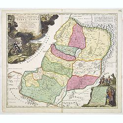
Iudaea seu Terra Sancta quae Hebraeorum sive Israelitarum. . .
Map of the Holy Land divided among the Tribes as well as in two kingdoms, Judah and Israel. The title cartouche shows Moses and Aaron. Lower right corner cartouche, which...
- $600 / ≈ €509
Date: Paris, 1709

De Haven en Straat von Gibraltar, Niewlyks getekend, en in`t licht gebracht door Johannes Covens en Cornelis Mortier tot Amsterdam.
Decorative map showing the siege of Gibraltar during the Spanish war of succession. This highly interesting map is richly ornated with three additional inset maps and vie...
Date: Amsterdam, 1710
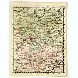
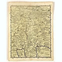
(Ochfenfurt, Hall, Bavaria, etc.)
Rare miniature map of Bavaria including the towns of Ochfenfurt, Hall, etc. From "Le theatre De Bellone, Contenant 48. nouvelles Cartes Geographiques, Des Païs-Bas ...
- $60 / ≈ €51
Date: Amsterdam, 1710

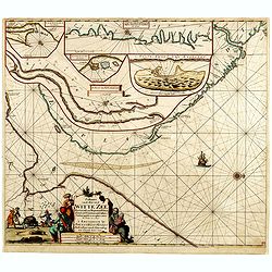
.Paskaart van de Mont van de Witte Zee,. Beginnende van Tiepena tot Pelitza, als mede van C. Cindenoes tot Catsnoes.
Fine sea chart of the southern part of the Barents Sea, oriented to the West. With five inset maps: - Swetenoes, de Kust van Laplandt, Lombascho, 'T Vaste Landt van Lapla...
Date: Amsterdam, c.1710
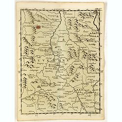
(Clermont, Brioude, Le Puy, etc.)
Rare miniature map including the towns of Clermont, Brioude, Le Puy, etc. From "Le theatre De Bellone, Contenant 48. nouvelles Cartes Geographiques, Des Païs-Bas Es...
- $60 / ≈ €51
Date: Amsterdam, 1710
(Hildesheim, Munden, Steinbrugge, Grubenhagen, etc.)
Rare miniature map including the towns of Hildesheim, Munden, Steinbrugge, Grubenhagen, etc. From "Le theatre De Bellone, Contenant 48. nouvelles Cartes Geographique...
- $60 / ≈ €51
Date: Amsterdam, 1710
Paskaart van de Mont van de Witte Zee,. Beginnende van Tiepena tot Pelitza, als mede van C. Cindenoes tot Catsnoes.
Fine sea chart of the southern part of the Barents Sea, oriented to the West. With 5 inset maps: - Swetenoes, de Kust van Laplandt, Lombascho, "T Vaste Landt van Lap...
- $1000 / ≈ €848
Date: Amsterdam, c.1710
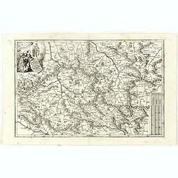
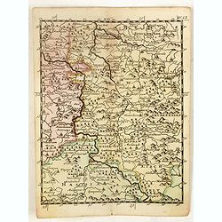
In Bohemia Moravia et Silesia . . .
A map of Czechoslovakia with Poland in the upper corner. Including the River Oder and Wroclaw (Breslaw)Heinrich Scherer (1628-1704) taught as Professor of Hebrew, Mathema...
- $175 / ≈ €148
Date: Munich c.1710
(Schweinfurt, Reineck, Hirschfeld, etc.)
Rare miniature map including the towns of Schweinfurt, Reineck, Hirschfeld, etc. From "Le theatre De Bellone, Contenant 48. nouvelles Cartes Geographiques, Des Païs...
- $60 / ≈ €51
Date: Amsterdam, 1710
![Le Royaume de Siam avec Les Royaumes Qui Luy sont Tributaries & c. / La Royaume de Siam avec les royaumes qui luy sont Tributaires, et les Isles de Sumatra, Andemaon, etc. . . [two sheet map]](/uploads/cache/40698-250x250.jpg)
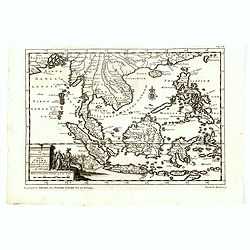
Le Royaume de Siam avec Les Royaumes Qui Luy sont Tributaries & c. / La Royaume de Siam avec les royaumes qui luy sont Tributaires, et les Isles de Sumatra, Andemaon, etc. . . [two sheet map]
Influential map of Southeast Asia and the East Indies including modern day Thailand, southern Vietnam, Cambodia, Malaysia, Singapore, Borneo, Sumatra and Java. Ottens inc...
Date: Amsterdam, 1710
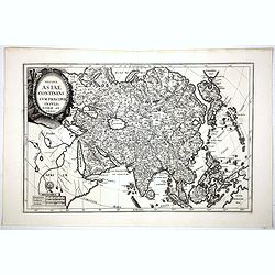
Totius Asiae continens cum praecipuis insulis eidem annexis
On this map Hokkaido is connected with Honshu and even bigger depicted than Honshu. In lower left cartouche a scale and a monstrance with the sign of the Society of Jesus...
Date: Munich, 1710
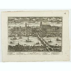
Blois ville capitale du Blaisois, Eveshé et Chambre des Comptes.
Bird-eyes view of Blois, published in Paris by Chereau who was active at rue St Jacques à S Remy.
- $100 / ≈ €85
Date: Paris, ca. 1710
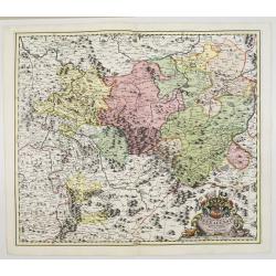
Principatus Isenacensis cum adjacentibus. . .
Detailed map centered on Gotha and Erfurt. Lower right splendid title cartouche.The map is painted in strong colors. Clearly from an show-piece atlas produced for a wealt...
- $200 / ≈ €170
Date: Nurenberg, 1710

Nansenbushu bankoku shoka no zu.
This wall-map is a great example of Japanese world maps representing Buddhist cosmology with real-world cartography. It is the earliest one and - therefore - the prototyp...
Date: Kyoto, (Hoei 7 = Year of the Tiger) 1710

De Stadt Jerusalem.
Plan of ancient Jerusalem from a Dutch bible after Villalpando. The print is in contemporary colors, which is extremely rare for a plate like this. Lower left the Temple ...
Date: Amsterdam, 1710

Landgraviatus Alsatiae tam superioris..
Alsace, in the far north-eastern corner of France, stands out from other French wine regions thanks to its strong Franco-Germanic influences. Alsace is the only French wi...
Date: Nurenberg, 1710
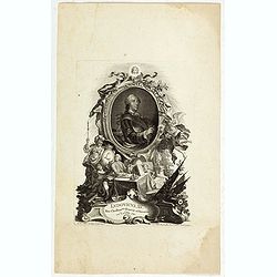
Ludovicus. XV rex chrisitan franciae et navarrae nat d:15. febr. 1710.
Portrait of Ludovicus XV, set in a decorative border.In lower part "Jo. Es. Nilson, inv et excutiv Aug V. et à Paris chez Rosselin Rue St. Jaques a l'Autel Saumur&q...
- $50 / ≈ €42
Date: Augsburg, Paris, 1710
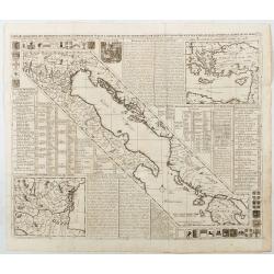
Carte de Geographie des Differents Etats de la Republique de Venise. . .
An attractive and detailed engraving of the Gulf of Venice and adjacent Italian and Dalmatian coastlines. The main map runs diagonally across the sheet with inset detail ...
Date: Amsterdam, 1710
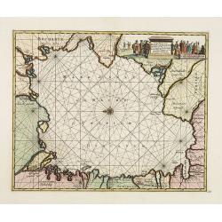
Carte marine de la mer Caspienne avec toutes ses Bayes Rivieres et Havres, dressée sur les observations des plus habiles Navigateurs,. . .
Strikingly engraved and attractive map of the Caspian Sea, showing major towns, ports, etc. Large decorative cartouche and compass rose.
- $500 / ≈ €424
Date: Leiden, 1710
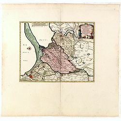
Les trois Iles, appellées en Allemand Werders, ou sont les Territoires de Dantzic, Marienbourg et Elbing dans la Prusse Royale avec les Côtes de la Mer Baltique, suivant la description de Olaus Jean Gotho, et autres Celebres Auteurs. . .
Fine and uncommon map including the town of Danzig and the region south of it. East to the top.Issued in Pierre van der Aa's very rare atlas "Nouvel Atlas …" ...
- $650 / ≈ €551
Date: Leiden, 1710
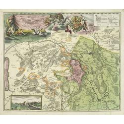
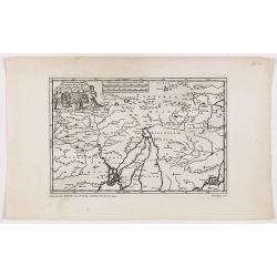
Geographica descriptio Montani cujusdam districtus in ..
Detailed map including the towns of Thurnau, Bayreuth, Culmbach, etc. With fine panoramic view of Thurnau. Upper left and right splendid title cartouches.The map is paint...
Date: Nurenberg, 1710

