Browse Listings

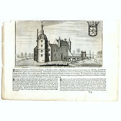
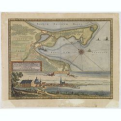
Prospectus veteris castelli Graviae.
One of the earliest views of the ancient Castle of Grave. Engraved by Casper Bouttats. With a description in Latin, French and Dutch.
Date: Amsterdam, 1695

Prospectus Castelli Boxtel.
One of the earliest views of the Castle of Boxtel. Engraved by Henricus Cause. With a description in Latin, French and Dutch.
Date: Amsterdam, 1695
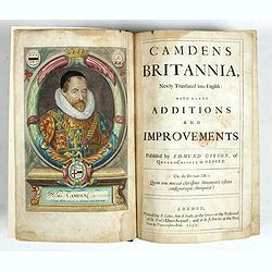
Camden's Britannia, Newly Translated into English with Large Additions and Improvements.
Splendid copy fully original colored (inclusive title-cartouche) of the first edition of Gibson's translation.Illustrated with an engraved portrait of Camden by R. White,...
Date: London, F. Collins for A. Swalle and A. / J. Churchill, 1695

Vaisseau du premier rang portant pavillon d'amiral.
Fine double-page engraved plate of a naval vessel, with the various parts of the ship numbered and identified. From Mortier's "Neptune François". From Mortier'...
Date: Amsterdam, 1695
Coupe d'une galère avec ses proportions - Quille d'une Galere sur le chantier.
Fine double-page engraved plate of a cutaway of a standard late 17th-century French galley with a detailed legend of parts (in French). Below is a representation of the k...
Date: Amsterdam, 1695
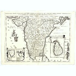
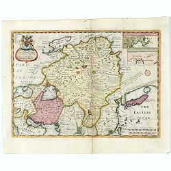
![[East coast of Africa, Arabia and west coast of India.]](/uploads/cache/04762-250x250.jpg)
[East coast of Africa, Arabia and west coast of India.]
Rare. Map of the east coast of Africa, Including Madagascar, the Arabian Peninsular, coast of Pakistan and west coast of India.Prepared by Joao Teixeira in 1649, this cha...
Date: Paris, 1664-1696
![[Title page] Atlas Nouveau contenant toutes les parties du monde . . .](/uploads/cache/49114-250x250.jpg)
[Title page] Atlas Nouveau contenant toutes les parties du monde . . .
Fine title page of classical architectural design incorporating portraits of royalty and battle scenes.
Date: Paris, 1696
Atlas nouveau contenant toutes les parties du monde, ou sont exactement remarqués les empires, monarchies, royaumes, estats, republiques & peuples qui s y trouvent & present..
Very fine example in atractive original colors of the second edition of this atlas by Pieter Mortier. The publisher of Amsterdam Mortier lived in Paris between 1681 and 1...
- $75000 / ≈ €63593
Date: Amsterdam c. 1696
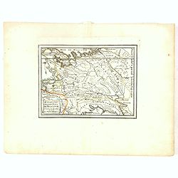
La Transilvania.
A scarce and very attractive detailed map of Transylvania and includes numerous coats of arms in the body of the map and a large decorative title cartouche. Scale cartouc...
Date: Venice, 1696
![Flandra parte occidentale: dedicata all'illustrissimo et eccelententissimo S. Giorgio Cocco, senatore meritissimo. . . [together with] Zelanda e Parte Orientale della Flandra. . . .](/uploads/cache/31286-250x250.jpg)
Flandra parte occidentale: dedicata all'illustrissimo et eccelententissimo S. Giorgio Cocco, senatore meritissimo. . . [together with] Zelanda e Parte Orientale della Flandra. . . .
Wall sized map of two joined sheets of Flanders, the coastline running from Calais to Zeeland in the Netherlands. Including major cities along the coast such as Dunkerque...
Date: Venice, 1696
![[Title page] Isolario dell'Atlante Veneto de P. Coronelli, parte I.]](/uploads/cache/47757-250x250.jpg)
[Title page] Isolario dell'Atlante Veneto de P. Coronelli, parte I.]
Very fine engraved architectural frontispieces of "Isolario dell'Atlante Veneto de P. Coronelli, parte I" by Vincenzo Coronelli, in 1696.More about title pages ...
- $500 / ≈ €424
Date: Venice, 1696
![[Title page] Atlas Nouveau Contenant Toutes les Parties du Monde, ou Sont exactement Remarques Les Empires, Monarchies, Royaumes, Estats . . . M.D.C.XCII.](/uploads/cache/47939-250x250.jpg)
[Title page] Atlas Nouveau Contenant Toutes les Parties du Monde, ou Sont exactement Remarques Les Empires, Monarchies, Royaumes, Estats . . . M.D.C.XCII.
Striking example of the title page of "Atlas nouveau contenant toutes les parties du monde, ou sont exactement remarqués les empires, monarchies, royaumes, estats, ...
- $750 / ≈ €636
Date: Paris, 1696
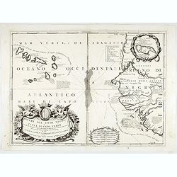
Bocche del Fiume Negro et Isole di Capo Verde. . .
This is a splendid map of the northwestern coast of Africa and the Cape Verde Islands.The map provides details of the various Portuguese discoveries in the region in the ...
- $600 / ≈ €509
Date: Venice, 1696

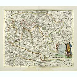
Marcomania hoggidi Merchesato de Moravia. . .
Although Komensky's map of Moravia was already known in his time, Coronelli used the obsolete map by Fabricius, with a lot of locations added by the publisher's unchained...
Date: Venice, 1696
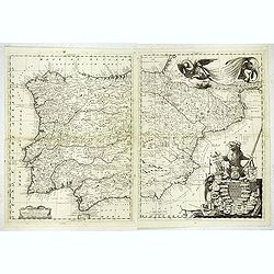
Parte Orientale della Spagna. . .
A scarce and very attractive double sheet detailed map of Spain and Portugal. This map appeared in the "Atlante Veneto", Coronelli's best known work. In a typic...
Date: Venice, 1696
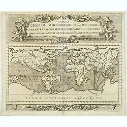
Tabula geographico-hydrographica motus Tom II p.132.
World map depicting ocean currents, volcanoes and deep-sea chasms. The continents are void of political detail and only major lakes, rivers and volcanoes are shown. There...
Date: Nuremberg, 1696
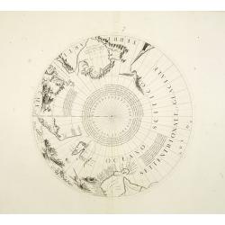
Two polar calottes from a globe.
Two polar calottes from 110 centimeters in diameter globe of 1688 including the northern part of Baffin Bay, Greenland, Iceland, Nova Zembla. Coronelli elected to follow ...
Date: Venice, 1696
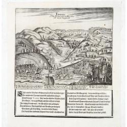
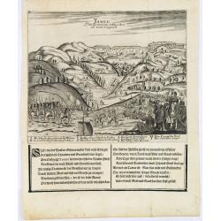
Prospectus Castelli Boxmerce / Prospectus Castelli Asten.
Early view of the castle of Boxmeer, engraved by H. Causé after a design by J. van Croes and published in "Vermakelykheden van Brabant en deszelfs onderhoorige land...
- $35 / ≈ €30
Date: Amsterdam, 1696

Die Stadt Narva. . .
An early of the town of Narva, located at the eastern tip of Estonia, on the Russian border.From the uncommon Hamburg edition "Viel Vermehrte Moscowitische und Pers...
Date: Hamburg, 1696
Tarku Urbs Tartaroum in Dagestan ad mare Caspium.
An early of Tarku, in the Republic of Dagestan. From the scarce Hamburg edition "Viel Vermehrte Moscowitische und Persianische Reisebeschreibung" by Adam Olear...
Date: Hamburg, 1696
Tarku Urbs Tartaroum in Dagestan ad mare Caspium.
An early view of Tarku, in the Republic of Dagestan. From the scarce Hamburg edition "Viel Vermehrte Moscowitische und Persianische Reisebeschreibung" by Adam ...
- $300 / ≈ €254
Date: Hamburg, 1696
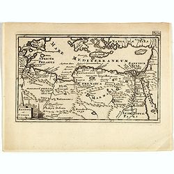
Aegyptus Et Cyrene.
A fine coastal region of Libya, also known as Pentapolis in antiquity. From "Introductio in Universam Geographicam" and edited by Johann Friedrich Heckel Philli...
- $50 / ≈ €42
Date: London, 1697
Neoburgum Fioniae oppidum. . .
Decorative plan and panoramic view of the town of Nyborg in Denmark at the coast of Baltic Sea in Fyn. Prepared by Count Erik Jönsson Dahlberg[h] (1625-1703). Military e...
Date: Stockholm, 1697
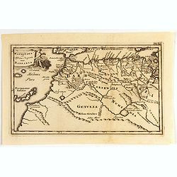
Mauritana et Africa Proria nunc Barbaria.
A pleasantly engraved map of the north-western part of Africa with the Canary Islands by Phillip Clüver after Strabo. With one cartouche.Phillip Cluver was a German geog...
- $50 / ≈ €42
Date: Leiden, 1697
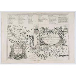
Disegno Idrografico del Canale Reale . . .
A decorative Coronelli map showing the Canal du Midi. It shows the extent of the canal from the Mediterranean sea at Narbonne to Toulouse. Featuring a pair of large coats...
- $300 / ≈ €254
Date: Venice, 1695-1697
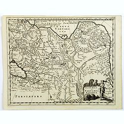
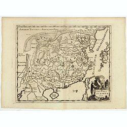
Scythia et Tartaria Asiatica.
A decorative and interesting eighteenth century map of Tartary and Scythia from an atlas first published in Leiden in 1624. Philipp Clüverius (1580–1623) was virtually...
- $125 / ≈ €106
Date: Leiden, 1697
Estats du Grand Duc de Moscovie . . .
An interesting small map of Moscovie by Nicolas de Fer. From his rare "Petit et Nouveau Atlas". The first edition was published in 1697 and was republished in 1...
Date: Paris, 1697
Imperii Sinarum Nova Descriptio.
Interesting map of China, shows the Great Wall, Macao and the Island of Formosa. From Philipp Clüver's famous Introductionis in Universam geographicam, first published i...
- $300 / ≈ €254
Date: Amsterdam, 1697
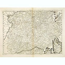
Ducato di Luxembourgo . . .
A beautiful and flamboyantly engraved map of Luxembourg. The map is the product of the late 17th century Venetian cartographer, Vincenzo Coronelli. A decorative title car...
Date: Venice, 1698
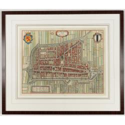
Delfi Batavorum vernacule Delft.
Detailed plan of the city Delft from Frederick de Wit's town book of the Netherlands. The plates are first published by Joan Blaeu one year after the peace of Münster an...
Date: Amsterdam, 1698
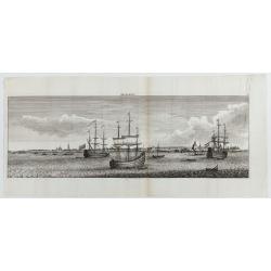
Archangel.
Decorative panoramic view of Archangel in Russia from "Reizen van Cornelis de Bruyn door de vermaardste Deelen van Klein Asia". Showing three large Dutch vessel...
- $300 / ≈ €254
Date: Amsterdam, 1698
Xantung, e Peking provincie della china. . .
A beautiful map depicting the area of Beijing with decorative title cartouche and scale cartouche. Information about the area at the top of the map.To the right the west ...
- $350 / ≈ €297
Date: Venice, 1698
Penisola dell'Indo di qua del Gange, e l isola di Ceilan..
India below the Tropic of Cancer, with an inset of Ceylon and Trincomalee.The remarkable Vincenzo Coronelli (1650-1718), encyclopaedist, geographer, inventor and Doctor o...
Date: Venice, 1698
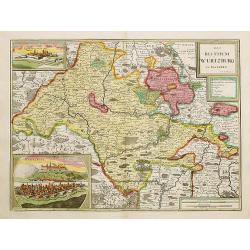
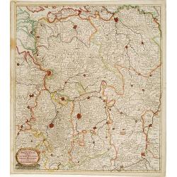
Das Bisthum Wurtzburg in Francken.
Rare map of Würzburg. With inset panoramic views of Würzburg and Köningshofen.The map is painted in strong colors. Clearly from an show-piece atlas produced for a weal...
Date: Nurenberg 1698
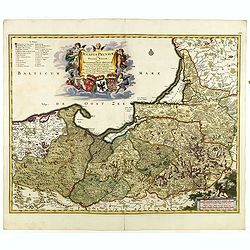
Ducatus Prussiae tam Polono Regiae. . .
Rare issue of Frederick de Wit's attractive map of the northern part of Poland, Prussia and the Baltic regions.Very decorative title cartouche including 3 coats of arms. ...
- $3500 / ≈ €2968
Date: Amsterdam, 1698
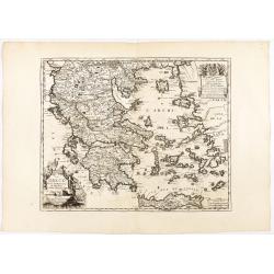
La Grèce, tirée des Mémoires de Monsieur l'Abbé Baudrand.
Rare map of Greece ornated with three cartouches, for the title, the dedication and the scale. The title cartouche, at bottom left, is illustrated with an allegory of Ven...
Date: À Paris, chez Jean Besson, sur le quay de l'Horloge du Palais, au Soleil d'Or, entre la rue du Harlay et la porte du Palais, [ca 1650-1699
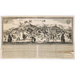
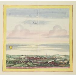
Naples. 1699. Nouvelle et exacte description de la tres-celebre & ancienne Ville de NAPLES
Only recorded large-scale broad sheet panoramic view of Naples with underneath in letterpress a description of the town's history : "Nouvelle et exacte description d...
Date: Paris, 1699
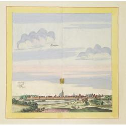
Templin
Very decorative and rare panoramic town view of Templin in Uckermark.The engraver and publisher of prints, Mrs. Anna Beek of the Hague, enlarged the print and mounted it ...
Date: The Hague, ca. 1700
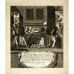
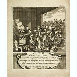
La boulangerie de la Trappe. 9
Print showing the bakery in Trappe. From a series of 19 prints, "Les travaux et les jours de la Trappe", illustrates the life of the Trappists, their manual act...
Date: Paris, ca. 1700
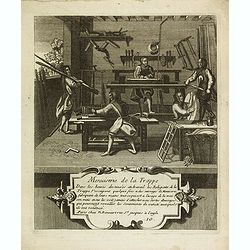
Menuiserie de la Trappe. 10
Print showing the carpentry of Trappe. From a series of 19 prints, "Les travaux et les jours de la Trappe", illustrates the life of the Trappists, their manual ...
Date: Paris, ca. 1700
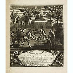
Travail des mains. 11
Print showing the manual labor of the religious of the abbey of Trappe. From a series of 19 prints, "Les travaux et les jours de la Trappe", illustrates the lif...
Date: Paris, ca. 1700

Cuisine de la Trappe. 12
Print showing the kitchen of the religious of the abbey of Trappe. From a series of 19 prints, "Les travaux et les jours de la Trappe", illustrates the life of ...
Date: Paris, ca. 1700
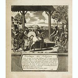
Vendange des religieux. 14
Print showing the vendange by the religious of the abbey of Trappe. From a series of 19 prints, "Les travaux et les jours de la Trappe", illustrates the life of...
Date: Paris, ca. 1700
Lessive de la Trappe. 15
Print showing the laundry of the abbey of Trappe. From a series of 19 prints, "Les travaux et les jours de la Trappe", illustrates the life of the Trappists, th...
Date: Paris, ca. 1700

Novissima Flandriae Comitatus tabula. . .
Rare issue of Theodorus Danckert's attractive map of eastern Belgium provinces, Flanders, with Brugge, Oostende, Gent, Mons, Antwerp, Cambray, etc..Decorative title carto...
Date: Amsterdam, 1700
Novissima et accuratissima totius Hungariae tabula. . .
Detailed map of Hungary with a decorative title cartouche with putti and an Ottoman warrior. The publisher gives credit to P. du Val in the title cartouche.
Date: Amsterdam, 1700
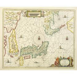
Nova et accurata Japoniae terrae Esonis, ac Insularum adjacentium.
The map is of interest in showing Korea as a curiously shaped island and in revising the shape of the three main Islands of Japan. A re-issue of Janssonius' map with the ...
Date: Amsterdam, 1700

Tabula Episcopatuum Leodiensis et Coloniensis. . .
Rare issue of Cornelis Danckert's attractive map of Limburg, shows the area of Cologne, Mainz, Trier, Jülich, Mons, Antwerp and Liege in Belgium.Decorative title cartouc...
Date: Amsterdam, 1700
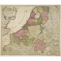
Septendecm. Provinciae Germaniae Inferior. . .
A general map of the Netherlands, Luxembourg and Belgium. Fine title cartouche showing Mercury, Neptune, globe, etc. Lower right coat of arms of 17 Provinces.
- $225 / ≈ €191
Date: Amsterdam, 1700

Accuratissima et maxima totius Turcici Imperii..
Rare issue of T. Danckert's attractive map showing the Arabian Peninsular, Turkey, Cyprus, Egypt and eastern part of the Mediterranean.Decorative title cartouche lower le...
Date: Amsterdam, 1700
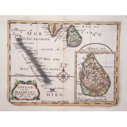
Ceylan, et les Maldives.
Exquisite map of Sri Lanka and the Maldives, with the southern tip of India shown at the top. Sri Lanka is shown in an inset named Ceylan Isle, qui est la Taprobane des A...
Date: Amsterdam 1700
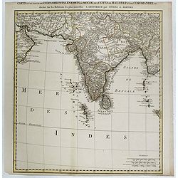
Carte d'une Partie des Indes Orientales, Etats du Mogol les Cotes de Malabar et de Coromandel.
A fine and highly detailed depiction of India and the surrounding region, this map extends from the Straits of Hormuz to the Gulf of Bengal. The Amsterdam publishing firm...
Date: Amsterdam, 1700
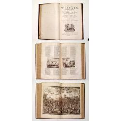
Alle De Wercken, soo Oude als Nieuwe van den Heer Jacob Cats, Ridder, oudt Raadtpensionaris Van Hollandt, &c. : Op nieus vermeerdert met des Autheurs Tachtig-jarig Leven, Huyshoudinge en Bedenckingen op Zorg-vliet.
A very good example of the collected works of the most celebrated Dutch author of the seventeenth century. Illustrated with over 400 engravings after van de Venne by Hond...
- $1900 / ≈ €1611
Date: Amsterdam, 1700
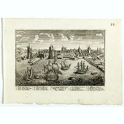
La Ville de la Rochelle, Capitale du pays d'Aunis. . .
A very decorative town view of La Rochelle.
- $350 / ≈ €297
Date: Paris, 1700
A New Map of Great Tartary and China with the adjoining parts of Asia
Two insets show the land to the northeast of China, according to Jesuit information. The map stretches from northern Russia and Nova Zemlya in the northwest to Formosa in...
Date: Oxford, 1700

Alssleben.
The engraver and publisher of prints, Mrs. Anna Beek of the Hague, enlarged the print and mounted it on larger paper: she colored it in pastel colors, adding extensive cl...
Date: The Hague, ca. 1700
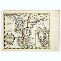
Presqu Isle de L'Inde. deca la Gange.. .
Two maps together on one sheet. General map showing the southern part of India, including the northern part of Shri Lanka. In an inset a detailed map of the most southern...
Date: Amsterdam, 1700
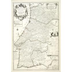
Le Portugal dedié au Roy.
Detailed oversized map of Portugal prepared by P. Placide Augustin, with fine title cartouche. Engraved by Inselin.Le Père Placide de Sainte-Hélène was the brother-in-...
- $300 / ≈ €254
Date: Paris, ca. 1700
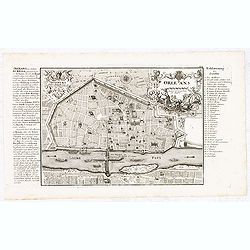
Orleans.
Nice scarce detailed town-plan of Orleans, from Bodenehr's "Atlas curieux" published in Augsburg.Incredibly detailed, shows the city of Orleans with many place ...
- $150 / ≈ €127
Date: Augsburg, ca. 1700
![[Title page] Libellus Novus Politicus.. Pars Quinta.](/uploads/cache/38475-250x250.jpg)
[Title page] Libellus Novus Politicus.. Pars Quinta.
Very skilfully engraved title page from a rare work printed by Eberhard Kieser: Thesaurus Philo-Politicus. Das ist Politisches Schatzkästlein guter Herren und bestendige...
- $80 / ≈ €68
Date: Frankfurt, 1700

Chorographia Terrae Sanctae in Angustiorem. . .
Rare. Large visually rich map decorated with illustrations of the sacred objects and places of Judaism. In the bottom center is a plan of ancient Jerusalem, and the route...
Date: Amsterdam, ca. 1700
![Bagdat le plan de Bagdat. [Manuscript plan of Bagdad]](/uploads/cache/45364-250x250.jpg)
Bagdat le plan de Bagdat. [Manuscript plan of Bagdad]
Manuscript plan of Baghdad, being a close copy of 'Les Six Voyages de Jean-Baptiste Tavernier en Turquie, en Perse et aux Indes' (1676). With a lettered key 1-16 to impor...
Date: France, ca. 1700
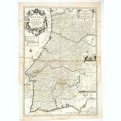
Le Portugal dedié au Roy.
Detailed over-sized map of Portugal prepared by P. Placide Augustin, with fine title cartouche. Engraved by Inselin.Le Père Placide de Sainte-Hélène was the brother-in...
- $400 / ≈ €339
Date: Paris, ca. 1700
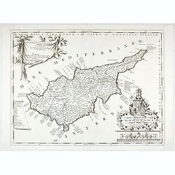
Acamantis insula hogidi Cipro . . .
Decorative map of Cyprus. The remarkable Vincenzo Coronelli (1650-1718), was a Franciscan Friar and appointed General of the Order in 1701. He was cosmographer to the Rep...
Date: Venice, 1700
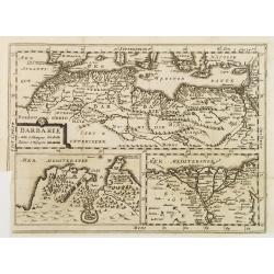
BARBARIE.
An uncommon and delightful map of Northern Africa extends from today's territory of Morocco as far as the Red Sea.With Inset maps of the Nile Delta and the Gulf of Tunis.
Date: Amsterdam, 1700
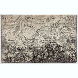
Delineatione della Piazza Forza di Belgrado.
Bird's-eye view of the Siege of Belgrade by the Austrian troops under the command of Prince Eugene of Savoy to capture the strategically important city from the Ottoman E...
Date: Rome, ca. 1700
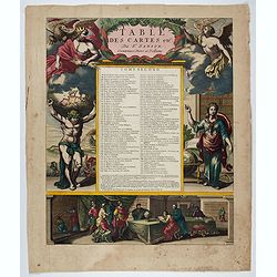
[Title page} Table Des Cartes etc: Du Sr. Sanson . . . Tome Second.
Large, powerfully engraved title page. Geographic scholars at work in a library are depicted along the bottom.Read more about title pages [+]
- $750 / ≈ €636
Date: Amsterdam, 1700
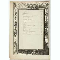
Table.
Index table page recto and verso of a world atlas.
Date: Paris, 1700
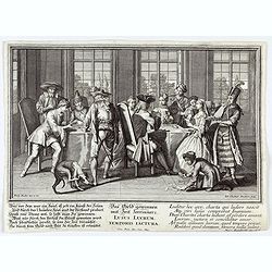
Lusus Lucrum Temporis Iactura.
Copper-plate engraving showing a group of fashionably dressed men and women playing cards. "Paulus Decker inv. et del.; Ioh. Christoph Steudner sculp.; Mart. Engelbr...
Date: Augsburg, 1700
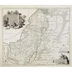
Het Heylige Land verdeeld in de twaalf stammen Israels ..
A fine map of the Holy Land depicting the tribes of Israel. A fine cartouche with Jesus preaching and healing. The scales with a cartographer and his pupil.
- $300 / ≈ €254
Date: Amsterdam, 1700

Oost-Indis Zee Magazyn - Arçenal des Indes Orientalis.
Decorative view of the East Indian Arsenal, now-a-says the Maritime Museum.
Date: Amsterdam, ca. 1700

Arcenal de l'Amirauté.
A decorative print of the 'T Landts Magazyn , or 'Scheepvaart Museum' (Naval Museum).
Date: Amsterdam, ca. 1700

D' Admiralyteyts Huys - La maison de l'Amirauté.
Decorative print of the "D'Admiralyteits Huys", Het Prinsenhof, of the Dutch East India Company VOC. Located at the Oudezijds Voorburgwal 195-199, Amsterdam.
Date: Amsterdam, ca. 1700

Schlanium vulgo Schlani Bohemiae oppidum.
Very decorative and rare panoramic town view of Schlan, Schlanium s. Slany.The engraver and publisher of prints, Mrs. Anna Beek of the Hague, enlarged this print, origina...
Date: The Hague, 1700
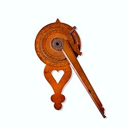
Nocturlabe in boxwood and brass.
Nocturlabe in boxwood and brass, the wheels maintained by a central nut presenting an annual calendar divided into months and days, an hour disc and a mobile alidade, the...
Date: England, ca. 1700
Ducatus Brabantiae tabula continens sacri imperii. . .
Rare issue of Cornelis Danckert's attractive map of Brabant.Decorative title cartouche lower left hand corner.
Date: Amsterdam, 1700
![[Drawing of a Tulip]](/uploads/cache/06597-250x250.jpg)
[Drawing of a Tulip]
Very detailed and well executed tulip drawing by an unknown artist belonging to the School of Anthony Claesz (1607/8-1649)This drawing was made for a 'Tulip book' painted...
Date: The Netherlands c.1700
![[Drawing of a Tulip]](/uploads/cache/06621-250x250.jpg)
[Drawing of a Tulip]
Very detailed and well-executed tulip drawing by an unknown artist attributed to the School of Anthony Claesz (1607/8-1649)This drawing was made for a 'Tulip book' painte...
- $1500 / ≈ €1272
Date: The Netherlands c.1700
![[Drawing of a Tulip]](/uploads/cache/06622-250x250.jpg)
[Drawing of a Tulip]
Very detailed and well executed tulip drawing by an unknown artist belonging to the School of Anthony Claesz (1607/8-1649)This drawing was made for a 'Tulip book' painted...
Date: The Netherlands c.1700
Döblen.
Very decorative and rare panoramic of Döblen in Sachsen.The engraver and publisher of prints, Mrs. Anna Beek of the Hague, enlarged the print and mounted it on larger p...
Date: The Hague, ca. 1700

