Browse Listings
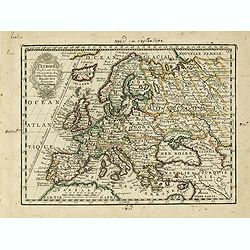
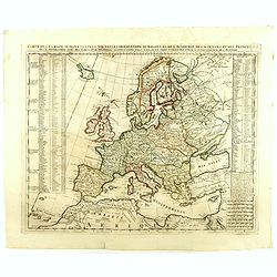
L' Europe Dressée sur les Observations de Mrs. de l' Academie Royale des Sciences..
Charming small map of Europe, including Iceland and the Mediterranean. Based on the geography of Guillaume Delisle.From Le Nouveau et Curieux Atlas Geographique et Histor...
- $150 / ≈ €127
Date: Paris, 1719
![[Title page] Le nouveau et curieux Atlas Géographique et historique ou Le Divertissement des Empereurs, Roys, et Princes. Tant dans laz Guerre que dans la Paix. . .](/uploads/cache/34361-250x250.jpg)
[Title page] Le nouveau et curieux Atlas Géographique et historique ou Le Divertissement des Empereurs, Roys, et Princes. Tant dans laz Guerre que dans la Paix. . .
Decorative title page. According to its title, this atlas was intended for the entertainment of emperors, kings, and princes!Together with 4 text pages.
- $120 / ≈ €102
Date: Paris, 1719
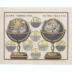
Globe Terrestre. / Globe Celeste.
A very decorative depiction of a terrestrial and celestial globe on a decorative base. The page is filled with seven diagrams.
- $175 / ≈ €148
Date: Paris, 1719
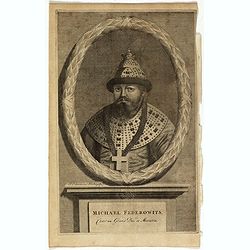
Michael Federowits . . .
Portrait of Tsar Michail Feodorovich (1596-1645). Engraving by Jacob Christopher Sartorius (1694-1737) engraver, active in Nuremberg. This well executed engraving was pub...
- $75 / ≈ €64
Date: Leiden, 1719
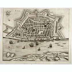
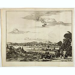
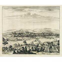
Riga.
Decorative view of Riga. This well executed engraving was published in 1729 and 1727 by Pieter van der AA, in Leiden in "Les Voyages tres-curieux et tres-renommez fa...
Date: Leiden, 1719
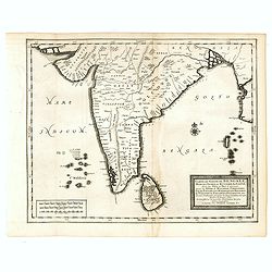
Carte du Golfe de Bengale, Mer de Indes, et Riviere du Gange, Avec les Pais et Iles d'alentour, Savoir les Cotes de Malabar, Cormandel, Ile de Ceylon, Les Maldives . . .
Detailed map of the Southern part of India with Ceylon. Good detail along the coasts of Malabar, Coromandel, the Maldives islands and the Kingdoms of Visipour, Golconda, ...
Date: Leiden, 1719
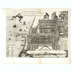
Waere affbeeldinge wegens het casteel ende stadt Batavia.
A good impression of Batavia's finely engraved and detailed plan, present-day Jakarta, the Dutch center of trading activities in the East Indies. Copied after Clement de ...
Date: Leiden, 1719
La grande & belle ville de Kaschan, en Perse. (Kashan in Iran)
Decorative view of Kashan in Iran. A branch of the Silk Road skirts the western and southern edges of Iran's central desert, passing through a string of small cities — ...
- $300 / ≈ €254
Date: Leiden, 1719
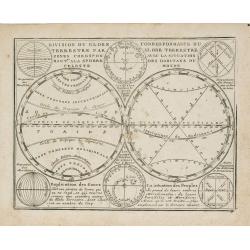
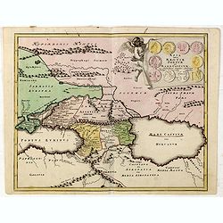
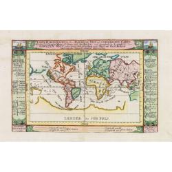
Division du Globe Terrestre par zones.. - Correspondance du Globe Terrestre avec la situation des habitants du monde.
A charming representation of various planetary models and systems according to the latest mathematical and scientific schemes of the day.From Le Nouveau et Curieux Atlas ...
Date: Paris, 1719
![[Title page] Le nouveau et curieux Atlas Géographique et historique ou Le Divertissement des Empereurs, Roys, et Princes. Tant dans laz Guerre que dans la Paix.](/uploads/cache/17244-250x250.jpg)
[Title page] Le nouveau et curieux Atlas Géographique et historique ou Le Divertissement des Empereurs, Roys, et Princes. Tant dans laz Guerre que dans la Paix.
Decorative title page. According to its title, this atlas was intended for the entertainment of emperors, kings, and princes!
Date: Paris, 1719
Saba, ville en Perse.
Decorative view of Sabā / Dakān Sorkh) which is a village in Vahdatiyeh Rural District in present-day Iran.In the foreground are camels and horses. This well-executed e...
Date: Leiden, 1719
Carte la plus nouvelle et plus exacte du royaume de Perse . . .
This is a decorative map of Persia and Central Asia. It has very good details of the region east of the Caspian Sea, showing modern-day Uzbekistan. The region is labeled ...
- $400 / ≈ €339
Date: Leiden, 1719
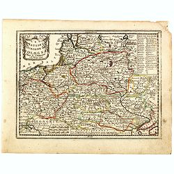
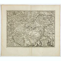
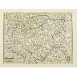
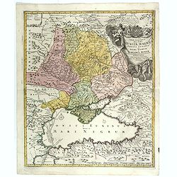
Les Estats de la Couronne de Pologne.
Lovely small map of Poland with title cartouche and a panel in the upper right corner listing local rulers.From Le Nouveau et Curieux Atlas Geographique et Historique.. b...
- $200 / ≈ €170
Date: Paris, 1719
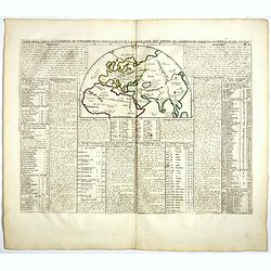
Carte De L'Europe Suivant Les Plus Nouvelles Observations De Messieurs De L'Academie Des Sciences . . .
Includes Iceland, and Russia in the north as well as the Black Sea and the northern tip of Africa in the south. Two tables, listing more than 175 countries along with the...
- $300 / ≈ €254
Date: Amsterdam, 1719
![Nouvelle carte de la province de Kilan en Persie . . . (Iran]](/uploads/cache/39437-250x250.jpg)
Nouvelle carte de la province de Kilan en Persie . . . (Iran]
Decorative map of southern part of the Caspian Sea in Northern Iran. This well executed engraving was published in 1729 and 1727 by Pieter van der AA, in Leiden in "...
- $300 / ≈ €254
Date: Leiden, 1719
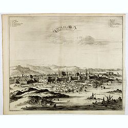
Astrakan, ville capitale du royaume du meme nom, en Moscovie. (Astrakhan)
Decorative view of Astrakhan. Astrakhan is where Europe ends and Central Asia begins. Its position on the Caspian Sea has ensured a long history as an important trading h...
- $300 / ≈ €254
Date: Leiden, 1719
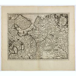
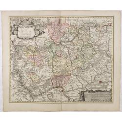
La Moscovie meridionale . . .
Decorative map centred on Moscow. This well executed engraving was published in 1729 and 1727 by Pieter van der AA, in Leiden in "Les Voyages tres-curieux et tres-re...
- $300 / ≈ €254
Date: Leiden, 1719
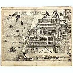
Waere affbeeldinge wegens het casteel ende stadt Batavia.
A good impression of this finely engraved and detailed plan of Batavia, present-day Jakarta, the Dutch center of trading activities in the East Indies. Copied after Cleme...
Date: Leiden, 1719
La Moscovie septentrionale . . .
Decorative view of area north of Moscow. This well-executed engraving was published in 1729 and 1727 by Pieter van der AA, in Leiden in "Les Voyages tres-curieux et ...
- $250 / ≈ €212
Date: Leiden, 1719
Terki, ville de la Circassie, dans l'Asie.
A very detailed panoramic view of Terki in the Caucasus, the capital of one of the most powerful Dagestani potentates of southeast Asia.Showing the Volga River.The town o...
Date: Leiden, c. 1719
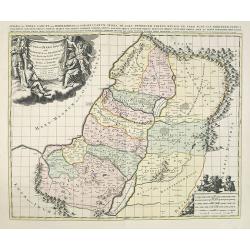
JUDEA seu TERRA SANCTA quae HEBRAEORUM sive ISRAELITARUM in suas duodecim Tribus divisa secretis ab invicem Regnis IUDA et ISRAEL expressis in super sex ultimi temporis eiusdem Terrae Provincijs. . .
Map of Palestine, showing the location of the various tribes, in two kingdoms, Judah and Israel as well as in six provinces. Shows Palestine on both sides of the Jordan, ...
Date: Amsterdam, 1720
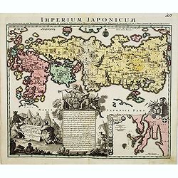
Imperium Japonicum.
The map is based on Engelbert Kaempfer's map of 1727. It shows a much-distorted outline for the Island of Japan and a wonderful decorative cartouche top left.Tobias Conra...
Date: Augsburg 1720
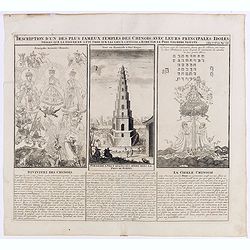
Description d'un des plus fameux temples des Chinois..
This impressive engraving is a wonderful example of Chatelain’s elegant plates.Divided in 3 panels, respectively showing the most important gods in the Chinese deities ...
Date: Amsterdam, ca. 1720
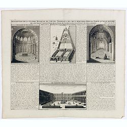
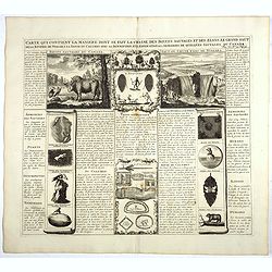
Description de la Celebre Mosquee de Com, Des Tombeaux Des Deux Derniers Rois de Perse qu'elle Renferme & du Grand Caravan-Serai De La Ville De Cachan Le Puls Magnifique de Tout L'Orient ...
Four views on one page with descriptive text showing the interior of the Mosquek, including the Sepulchre of Abas the Second and Sefy the First, along with the Tomb of th...
Date: Amsterdam, 1720
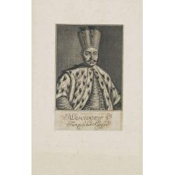
Mahomet V. Türkischer Kayser.
Portrait of Mahomet V. son of Mustapha II. succeeded in 1730, on the deposition of his uncle, Achmet III.Mahomet was more respectable for his pacific disposition, than hi...
Date: Germany, c. 1720
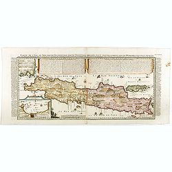
Carte de l'Ile de Java: partie Occidentale, partie Orientale, Dressée tout nouvellement sur les Mémoirs les plus exacts, Avec une Table des principales villes de cette Ile. . .
One of the finest large-scale maps of Java, giving good information regarding the VOC settlements An inset plan of Batavia and clearly indicated rice fields, mountains, f...
- $1500 / ≈ €1272
Date: Amsterdam, 1720
Partie Meridionale de Moscovie. . .
Scarce map centered on Moscow including Azow and part of present-day Ukraine in the bottom part of the map. The map is based on Delisle's important map of the region with...
- $750 / ≈ €636
Date: Amsterdam, 1720
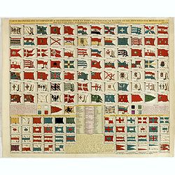
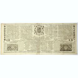
Carte des pavillons accompagnée d'observations pour en faire comprendre le blazon et les différentes devises aussy bien que d'une table alphabétique pour les trouver facilement.
A plate of 88 marine flags, including Malta, Turkey, Middelburg, Amsterdam, Portugal, Monaco, Tuscany, China, Nanking, the French Royal flag, the French admiralty flag an...
- $1200 / ≈ €1017
Date: Amsterdam, 1720
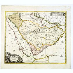
Arabiae Felicis, petrae et desertae.
A very striking map with a finely decorated title cartouche, published by Valk & Schenk, utilizing Jansson's original plate. Interestingly, this map uses the names th...
Date: Amsterdam, 1720
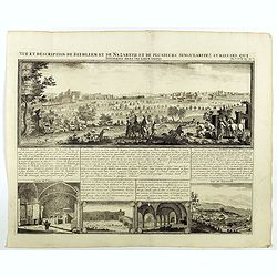
Vue et description de Bethleem et de Nazareth . . .
Decorative panoramic view of Bethlehem and Nazareth, among 3 other views of the Hall of the Annunciation and Church of Cana .From Chatelain's monumental 7 volume "At...
- $200 / ≈ €170
Date: Amsterdam, 1720
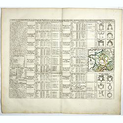
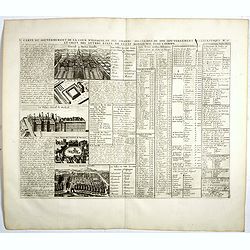
Carte du Gouvernement Ecclesiastique de France Divise en ses Archeveschez, Eveschez, Archidiaconnez, Archipretrez, Doyennez, et Parroisses.
This impressive plate provides a comprehensive list of the ecclesiastical divisions in the country with their corresponding coats of arms. A small inset map depicts the l...
- $55 / ≈ €47
Date: Amsterdam, 1720
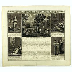
Mariage des Turcs & des Armeniens, avec la ma niere dont se font les demonstrations d'amour . . .
Showing the marriage rituals and lives of Turks and Armenians. Five engravings set round a text panel in French. From Chatelain's monumental 7 volume "Atlas Historiq...
- $150 / ≈ €127
Date: Amsterdam, 1720
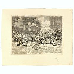
Monument consacré a la posterité en memoire de la folie incroyable de la XX. année du XVIII. siecle. Ter eeuwiger gedagtenisse der dwaasheid van het XX. jaar der XVIII. eeuw.
Monument consecrated to posterity in memory of the unbelievable folly of the 20th year of the 18th century.A caricature in prose and verse satirizing the first truly inte...
- $250 / ≈ €212
Date: Amsterdam, 1720
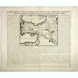
Carte De L'Asie Inferieure Selon Les Auteurs Anciens, Enrichie de Remarques Historiques sur les Changemens qui y sont arrivez.
Text page with inset map (220x269.mm.) of Turkey, including Cyprus from Chatelain's monumental 7 volume "Atlas Historique". Henri Abraham Chatelain (1684 – 17...
Date: Amsterdam, 1720
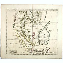
Le Royaume de Siam avec Les Royaumes Qui Luy sont Tributaries & c.
Influential map of Southeast Asia, including modern day Thailand, southern Vietnam, Cambodia, Malaysia, Singapore, Borneo, Sumatra and Java. Chatelain incorporated inform...
Date: Amsterdam, c.1720
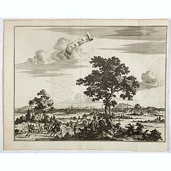
Namur.
A very RARE panoramic of the city of Namur, with a numbered legend in both lower corners.The plate is numbered in red pencil in upper right corner.Engraved by Pierre Avel...
- $150 / ≈ €127
Date: Paris, 1690-1720
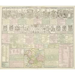
Carte genealogique de la famille Royale de Brunswick . .
A very detailed composite sheet with a genealogical table of the German royal families of Brunswick, Luneburg and Hanover, with descriptive French textZacharie Chatelain ...
- $50 / ≈ €42
Date: Amsterdam, ca. 1720

Amsterdam Capitale de la Hollande.
A panoramic of Amsterdam seen from 't IJ. Set within a decorative border, printed from a separate plate. Rare.
Date: Leiden, 1720
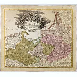
Regnum Borussiae gloriosis auspicijs Seerenissimi et Potentissimi Princip Friderici III Primi . . .
Map covering the region along the Baltic Sea from Prussia, Memel, to northern Poland, extending south to Poland, centered on Danzig, Konigsberg, Heilsperg, etc. Beautiful...
Date: Nuremberg, 1720
Carte du gouvernement ecclesiastique d'Angleterre . . .
Elegant engraving of the ecclesiastical government of England, with an engraving showing three images: in the centre, an ecclesiastical assembly (Convocation of the Clerg...
- $100 / ≈ €85
Date: Amsterdam, 1720
Asia intra Maeotim Pontum et Mare Caspium. . .
Striking map the Black Sea and Caspian Sea regions, featuring the geographical features known to the ancients and decorated with a vignette and 10 medallions.From "D...
- $195 / ≈ €165
Date: Nuremberg, 1720
Carte qui contient la manière.. Niagara..
A series of 12 engravings together with descriptive text, derived from the works of Lahontan and Hennepin, illustrating the methods of the Indians hunting buffalo and sim...
Date: The Hague 1720
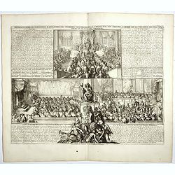
Représentation du parlement d'Angleterre, les chambres assemblées . . .
Engraving showing the British Parliament and an assembly before the King of England. From Chatelain's Atlas Historique, 1732-1739. In upper right margin: 'Tom. 7. No 26.H...
- $80 / ≈ €68
Date: Amsterdam, 1720
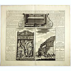
Antiquez curieuses qui se trouvent aux environs de Smyrne, et sur le chemin d'Ephese.
Folio sheet describing and depicting ancient Greek monuments and ruins in Smyrna (Izmir). From Chatelain's monumental 7 volume "Atlas Historique". Henri Abraham...
Date: Amsterdam, 1720

Imperii Sinarum nova descriptio.
Schenk and Valk's rare early 18th century issue of Janssonius milestone map of China, Korea and Japan after Martino Martini. Engraved by Johannes van Loon. The overall ba...
Date: Amsterdam, ca. 1720
Carta Hydrographica oder Algemeine Welt. . .
World map in Mercator projection. Showing California as an island. In the upper left and right-hand corner two ships. The map is showing the important trade routes.
Date: Augsburg, 1720
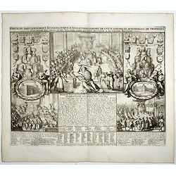
Carte du gouvernement civil ecclésiastique de moscovie, l'état des revenus et l'ordre de la justice et des officiers de la cour.
Interesting sheet with a detailed plan of Moscow, plus two large coats-of-arms, with descriptive French text, from Chatelain's monumental 7 volume Atlas Historique. In up...
- $950 / ≈ €806
Date: Amsterdam, 1720
Partie Meridionale de Moscovie. . .
Centered on Moscow including Azow and part of present-day Ukraine in the bottom part of the map. The map is based on Delisle's important map of the region with revisions ...
- $200 / ≈ €170
Date: Amsterdam, 1720
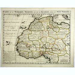
Carte de la barbarie, Nigritie et de la Guinée avec les pays voisins . . .
Showing the imaginary island of ''Borondon'' or Saint Brendan's Island, also known as Saint Brendan's Isle, supposedly situated in the North Atlantic somewhere west of No...
Date: Amsterdam, 1720
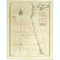
Costes de L'Afrique .. ..Cap de Bone Esperance..
In the upper right-hand corner inset map of Saldanha Bay. Numerous place names, soundings and sand banks are shown round the island and the regions are defined by origina...
Date: Amsterdam, 1720
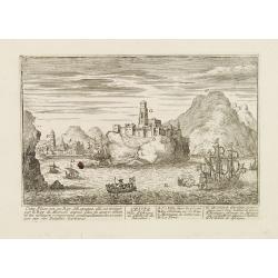
Ceuta Ville d'Afrique au D'estroit de Gibraltar.
A very RARE panoramic view of the city of Ceuta, including a numbered legend in both lower corners.Published by the brothers Chéreau, active in Paris at rue st.Jacques a...
Date: Paris c.1720
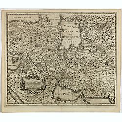
Carte des Pays voisins de la Mer Caspiene. . .
A most attractive and detailed map of the region between the Black and Caspian Seas after De L'Isle. The two Seas are decorated with compass roses. This is one of the few...
Date: Amsterdam, 1720
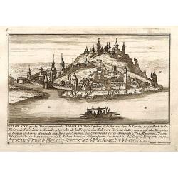
Belgrad / Biograd.
A very RARE panoramic view of the city of Belgrade, including a numbered legend in the lower part.Published by the brothers Chéreau, active in Paris at rue st.Jacques au...
Date: Paris, c.1720
Tabula Geographica qua pars Russiae Magnae. . .
Homann's map is based upon Beauplan's general map of Ukraine but depicts the political changes of the preceding years. With decorative cartouches. Giving good detail alon...
Date: Nuremberg, 1720

Vue et description des principales villes de l'Armenie et de la Georgie avec les habillements des femmes du pays, et ceux des prêtres et religieux armeniens. . .Tom: V N° 11 Pag: 28
View and description of the principal Armenian and Georgian cities with illustrations of Armenian women's garments as well as priests' and monks' clothing. The views are ...
Date: Amsterdam, ca 1720
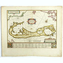
Mappa Aestivarum Insularum, alias Barmudas..
The map is the rare re-issue of the Blaeu's copperplate of 1630. The map includes the arms of Bermuda and England, and lists proprietors of the various tribes into which ...
Date: Amsterdam, 1720
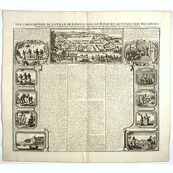
Vue et description de la Ville de Lovango dans le Royaume du Congo. . .
On top a large view of the fabled city of Lovango, text surrounded by ten vignettes of the people and ceremonies of the Kingdom of Congo.Zacharie Chatelain (d.1723) was t...
Date: Amsterdam, 1720
Nassovia Principatus Cum omnibus ei pertinentibus Comitatibus Dominiis ac Praefecturis ut et Confiniis intra Lahnun, Rhenum, et Moenum Flumina, ad situm verum exacte delineatus a Joh. Jac. Stetter. U.J.L. Idstenio-Nassovio . . .
Decorative map of the area between the rivers Rhine and Meuse, including Mainz, Koblenz, Frankfurt, Saarbrucken, etc.Includes an elaborate cartouche and coat of arms.The ...
- $150 / ≈ €127
Date: Amsterdam, 1720
Kort Begryp van Duytsland, de drie Ryx Collegien in hunne Wapens en Zittingen. Kreits Verelingen en Aantekenigen door C. Specht't Utrectht.
Second state of this decorative table of family escutcheons, crests and coats of arms, for various German and Dutch princes and nobles of the 16th, 17th and 18th Centurie...
Date: Amsterdam, 1720
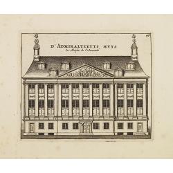
D' Admiralyteyts Huys - La maison de l'Amirauté.
Decorative print of the Admiralty House of the V.O.C., now-a-days Maritime Museum in Amsterdam.
Date: Amsterdam, c.1720
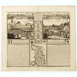
Succession Des Empereurs Du Japon Avec Une Description Du Meurtre De L'Empereur Cubo Et La Reception Des Ambassadeurs Hollandais. . .
The plate is showing the murder of the Emperor Cubo at Kyoto, the arrival of one of the early Dutch embassies.A small map of Honshu in a central panel. Plate from his &qu...
Date: Amsterdam, 1720
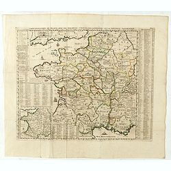
Carte Geographique du Royaume de France, avec des remarques curieuses sur l'ancienne, et la nouvelle geographie.
Map of France with a key table to the towns on both sides.Zacharie Chatelain (d.1723) was the father of Henri Abraham (1684-1743) and Zacharie Junior (1690-1754).They wor...
Date: Amsterdam, ca. 1720
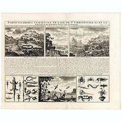
Particularitez Curieuses de l'Ile de St. Christophle et de la Province de Bemarin . . .
Six meticulously detailed and engraved scenes of the island of St. Kitts, also known as Saint Christopher, and the province of Bemarin, indigenous plants, animals, reptil...
Date: Amsterdam, 1720
![Malines. [Mechelen]](/uploads/cache/13125-250x250.jpg)
Malines. [Mechelen]
A very RARE panoramic town view of Mechelen, including a numbered legend in the left lower corner.Published by the brothers Chéreau, active in Paris at rue st.Jacques au...
Date: Paris, c.1720
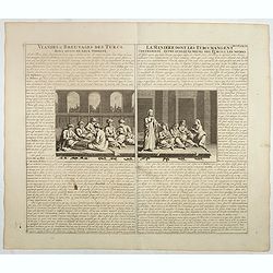
Viandes & breuvages des Turcs . . . / La manière dont les Turcs mangent . . .
Interesting sheet with a detailed views illustrating the lunch time in turkey, with descriptive French text, from Chatelain's monumental 7 volume Atlas Historique. In upp...
- $55 / ≈ €47
Date: Amsterdam, ca. 1720
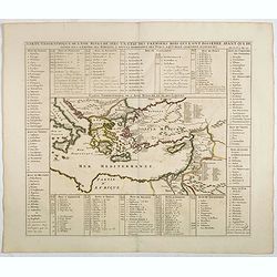
Carte geographique de l'Asie mineure avec un etat des premiers rois. . .
Map of the Mediterranean. This impressive engraving is a wonderful example of Chatelain’s elegant plates from his "Atlas Historique, Ou Nouvelle Introduction A L�...
- $120 / ≈ €102
Date: Amsterdam, ca. 1720

Nostre Dame de Lorette.
A very RARE panoramic of Lorette and the church, including a numbered legend in both lower corners.The plate is numbered in black pencil in upper right corner.Published ...
Date: Paris c.1720
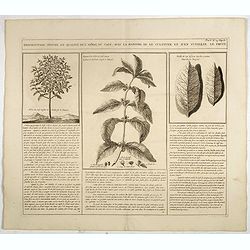
Description, figure et qualité de l'arbre, du café, avec la manière de le cultiver et d'en cueillir le fruit.
Decorative copperplate engraving showing a coffee tree, plant and fruit, with an lengthy description about its growing process.From Chatelain's monumental 7 volume "...
- $75 / ≈ €64
Date: Amsterdam, 1720
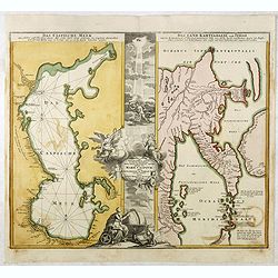
Das Caspische Meer / Das Land Kamtzadalie ...
Two maps on one sheet with the Caspian Sea on one side and northeastern Russia and Kamchatka on the other. The map of the Caspian Sea reflects the survey work of Russia�...
- $450 / ≈ €382
Date: Nuremberg, 1720

Carte Particuliere d'une Partie d'Asie ou sont Les Isles D'Andemaon, Ceylan, Les Madives . . .
An impressive large sheet chart including the Red Sea, the coasts of Somali, Yemen, east coast of the Arabian peninsula. One of the early maps to focus on this area. Nume...
- $1500 / ≈ €1272
Date: Amsterdam, 1720

Stoel des Oorlogs in America Waar in Vertoont Werden Alle Desself Voornaamste Eylande . . .
Large impressive map of the West Indies with the Gulf of Mexico and Florida. The map shows prominently in the center Cuba, Haiti, the Bahamas and Florida, which is here m...
Date: Amsterdam, c. 1720
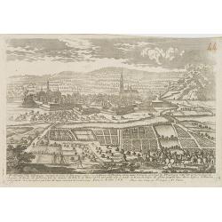
Fribourg Ville d'Allemagne Capitale du païs de Brisgaw.
A very RARE panoramic of the city of Fribourg. The plate is numbered in red pencil in the upper right corner.Engraved by Pierre Aveline (Paris, c.1656 - 23 May 1722). He ...
- $250 / ≈ €212
Date: Paris, 1690-1720
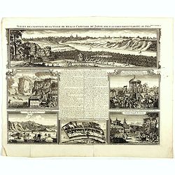
Vue et description de la Ville de Meaco Capitale du Japon. . .
Top part of the print shows the town of Meaco (Kyoto) at that time the capital of Japan, with a coach and horses in the foreground. Other parts show among other things th...
- $450 / ≈ €382
Date: Amsterdam, 1720
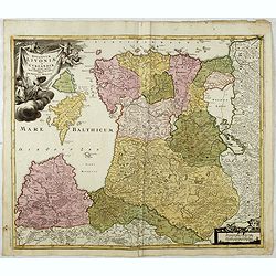
Ducatuum Livoniae et Curlandiae cum vicinis Insulis Nova Exhibitio Geographica. . .
Detailed map of the northern Baltic coast by Homann, pre-dating the privilege.
Date: Nüremberg, 1720
Carte pour servir à l'intelligence de l'histoire de la chronologie et de la géographie des empires des Assiriens, des Perses, des Egyptiens et des Chinois.
Interesting sheet with a map of the classical world showing the empires of the Assyrians, Persians, Egyptians and Chinese, with descriptive French text, from Chatelain's ...
- $75 / ≈ €64
Date: Amsterdam, 1720
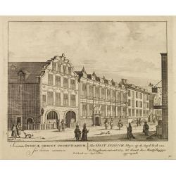
Het Oost Indisch Huys op de Suyd hock..
A decorative print of the East Indian House , the headquarters of the V.O.C., a place for meeting, trading and storage of spices and ship equipment.The maps and charts we...
Date: Amsterdam, 1720
Carte du Gouvernement de la Cour d'Espagne. . .
Engraved text sheet, providing a detailed description of the infrastructure of Spain's ecclesiastical and military government as well as information listed in a lengthy t...
- $75 / ≈ €64
Date: Amsterdam, ca. 1720
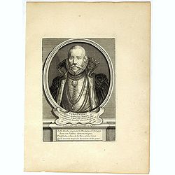
Ticho-Braché . . .
Uncommon portrait of Tycho Brahe, (1546 - 1601) engraved and published by Étienne Jehandier Desrochers ( Lyon 1668 - Paris 1741). Brahe was a Danish astronomer whose wor...
- $150 / ≈ €127
Date: Paris, 1720
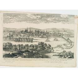
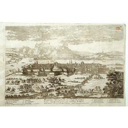
Treves en Allemend Trier.
A very RARE panoramic view of the city of Trier. The plate is numbered in red pencil in the upper right corner.Engraved by Pierre Aveline (Paris, c.1656 - 23 May 1722). H...
- $200 / ≈ €170
Date: Paris, 1690-1720
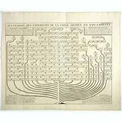
Succession Des Empereurs De la Chine divisée en XXII. Familles.
Showing successions of the Emperors of China divided into 22 families, copper engraved plate from "Atlas Historique". Zacharie Chatelain (d.1723) was the father...
- $100 / ≈ €85
Date: Amsterdam, 1720

